free to be able to rate and comment on reports (as well as access 1:25000 mapping).
At last! I was heading for the hills again.
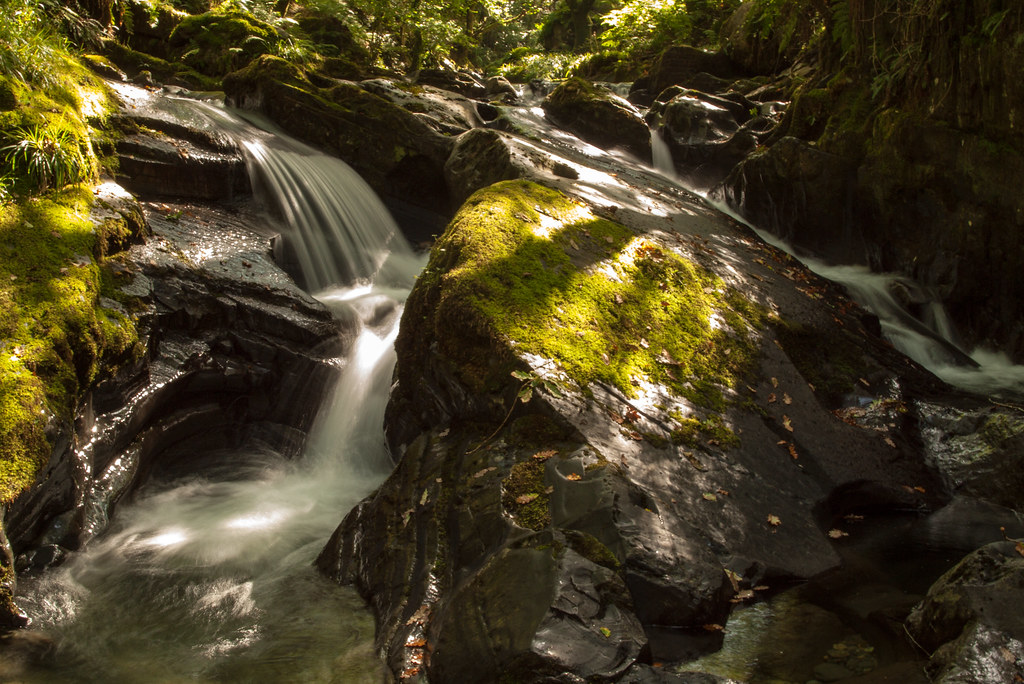
My objective for today was the Tarren Hills above Abergynolwyn, a group I had been meaning to get round to for a while. It was already warming up when I left the car by the Community Centre in the middle of the village and headed up the steep road towards Nant Gwernol Station, the terminus of the scenic Talyllyn railway. After a couple of hundred yards, the way leaves the road and follows the footpath first up and then down into the beautiful valley of the Nant Gwernol. The valley is steep sided, shaded by deciduous trees and the brook tumbles over cascade after cascade. Just lovely.
After a short distance the path splits, take the left hand fork climbing slightly, this leads to the bridge to Nant Gwernol station. The new slate chips are a giveaway. On reaching the level of the station it is clear it is at the bottom of a steep incline that the laden slate trucks had to be winched down.
At the top of the incline it is still possible to see the massive wooden brake drum in its housing. Apparently it didn’t always work, and if you look hard enough it is possible to see remnants of the wreckage!
![Drum brake.jpg]()
From the brake house the path follows the old slate level for a good half mile or so to the point where another footbridge crosses the stream, and the path turns left into the side of valley of Nant Moelfre. After a couple of hundred yards there is another fork in the path, carry straight on taking the way marked ‘Long Route’! The path then zigzags up and right, turning left where it emerges onto a wide well-made forestry track. A few hundred yards further on there is a fork in the track, take the right hand fork as the left doubles back away from the mountain. The 1:25,000 maps seem to show a number of tracks or paths running from this main track, but in reality they don’t seem to be there, perhaps they have been swamped by the trees. Tarrenhendre looms large, high above the forest.
![Tarrenhendre from the track.jpg]()
The track does take you quite a long way to the right before finally curving back towards the hill. On this final stretch all the trees to the right of the track have been felled, and this makes it easy to see the notch in the ridge above that is the key to climbing Tarrenhendre from this side. Just to make it even more obvious, the slope just beyond the path is still clad in dense tree cover. There is a faint path the winds up the steep slope to the right of a stone chute. Just below the notch the path has eroded into a stream bed, and it looks like an ascent after rain will be a soggy affair. The morning dew made it damp enough as it was.
So far the route had gone from 45 metres above sea level to about 450.
The next stretch is directly up a steep grass slope alongside a fence that leads to the summit of Tarrenhendre. This is one of those slogs that is best taken with the brain in neutral just concentrating on the next step upwards, over and over again. There is a shoulder that has the impression of being the top but it is a false dawn, it’s only about halfway.
Eventually the slope ends, and the peat-hagged flat top of Tarrenhendre is reached. The only feature of note is the small cairn off to the right of the main route, on this side of the fence. Even though there is little to photograph, a ‘strategic photographic break’ is called for to get your breath back!
Following the fence, the way drops quite a way down to the continuing ridge. In fact it drops back to around 450 metres, and it is clear that there are further ups and downs along the three miles or so before the rise, steep rise, to Tarren y Gesail. These Tarrens make you work hard for your ‘tick’!
The way is obvious, the ridge is well defined and the fence would be a perfect guide even in thick mist, but fortunately the sun is now beating down and is burning off the last of the haze.
Over the little top and down again, and then the steady pull up Foel y Geifr begins. Soon after the start of the climb there is a stile that leads over the fence, and hints at a path through the trees that contours Foel y Geifr to the left. Not trusting a path through a plantation, I choose to ignore this and instead climbed down a couple of rocky steps to the right and then followed an easy clear path to the right of the trees. At the top of the Foel y Geifr the path meets a stile which leads to a wide and clear break in the trees that winds gently to the left to reach the col at the foot of Tarren y Gesail.
At the col there are signs exhorting you to avoid damaging the ‘the only Organic, sustainable woodland in the country’. I somehow can’t imagine people using Growmore on trees, but there you go.
The way ahead is once again a Tarren slog, steeply uphill on grass. Head down, wipe the sweat from your brow….
It’s all worth it for a grand view from the top of this grassy dome, Tarrenhendre to the south west, the sea to the west, and Cader Idris to the north.
The way down is by following the ridge (I use the term loosely), which curves down to the left, meeting another plantation of trees. Follow the fence steeply down, and don’t be tempted by the forestry track about halfway down – it may get you to where you want to be, but it goes a long way about it. Far better to just continue to drop straight down to meet the stream at the bottom of the slope. Hop over the gate at the corner of the plantation, and along a narrow strip between the trees and the stream. It had been cut up somewhat by cattle, but worse was to come. Turning the corner the gap between the trees widens and the way enters a sloping field that has been seriously churned up by cattle, and yes I did find out the hard way that cow-pats are slippery….
![Across the waste tip.jpg]()
Head downhill westwards when the trees allow, and you enter an area that was once a hive of slate quarrying activity. The path hops over a stile and is back into light woodland. Just after the passing the remains of a ‘level’ bridge (the actual bridge is long gone), I meet a couple of the culprits that had been churning up the ground. These cattle were impressive beasts, built like big red tanks with enormous Chopper handlebar horns, a bit like McMoos, but not so shaggy. Fortunately, despite their impressive armoury, they were fairly timid and they decided to stomp off in the opposite direction.
![A close encounter.jpg]()
A little attention is needed in these woods as there is a left hand fork that should be taken, as this is the shortest way round the massive hole in the ground that is the remains of the Bryn Eglwys quarry. From here the Level is a clear path down that eventually meets another forestry track. The track will eventually meet the road that leads into the village, but that is a fairly uninspiring way to go. A few hundred yards along the track is a fingerpost saying ‘Gorsaf’ (station) that points left downhill into the valley. The path is well made and zigzags down to the stream just below a very pleasant set of falls.
The path is a wonderful sylvan delight, continuing downhill alongside the stream which seems to fall over a cascade every few yards.
 A lovely waterfall
 by
cliveg004, on Flickr
This whole stretch along the valley back to Abergynolwyn is an absolute joy, and it was here that I met the first people I had seen all day.
The Tarrens are a worthy and strenuous outing, only just over the 610 metre mark, but total ascent is over a 1,000 metres to bag the pair.
It was only lunchtime, and the weather was hot and dry, so there was still time to go for a quick bonus hill on the way home.
I must confess that I didn’t even realise that Gallt y Daren existed until recently, it is hardly an imposing peak when viewed from the single track road that winds upwards from the A470 at Bronaber. It is worth noting that the big forestry plantation of Coed y Brenin marked on the 1:25,000 map has been completely felled, so this side of the hill is a bit of a wasted lunar landscape now. There is a still a clear sign that you have reached the start of the climb, a cattle grid next to an imposing red Danger sign that warns of the perils of being blown up by unexploded munitions left lying about by the military. Entry to the whole area to the west of the cattle grid (except the road) was prohibited until only a few days ago.
I would recommend approaching this hill from the west, as I was to find out later the road up from Bala has gate after gate after gate….
The cattle grid is at about 500 metres , and the summit of Gallt y Daren is only about 3/4s of a mile away, so this really is quick and easy. A quad bike track provides a easy path gently uphill to Foel Boeth, and from there it is a simple case of hopping over the fence, past a fossilised telegraph pole, to the rocky outcrop that marks the summit.
This little mountain is only just over the 2,000 foot mark and hardly appears to be anything of note when seen from the road below. However, on a day like today when the visibility is reasonably good, it becomes obvious what a vantage point this is.
This little hill stands in the middle of all the major mountain ranges in North Wales, and they are all visible. To the east is the Berwyn and the Arenig, to the south the Arans and Cader Idris, to the west the Rhinogs, and of course to the north there is Snowdon itself.
A great place just to sit and look!
It’s been a grand day out!
