
Pleasant Hill Walk
Route: Capital View walk and Swanston
Date walked: 30/05/2015
Time taken: 3 hours
Distance: 4km
Ascent: 203m
My partner Susan and I set out for a walk in the Penland Hills on Saturday 30/5/2015. My original intention was to try the Allermuir Hill and Swanston Walk, however, the climb up the steep incline at Hillend Hill established the fact that I was not yet fit enough for the larger hills. Instead we took our fall-back route "The Capital View Walk".
 .
.
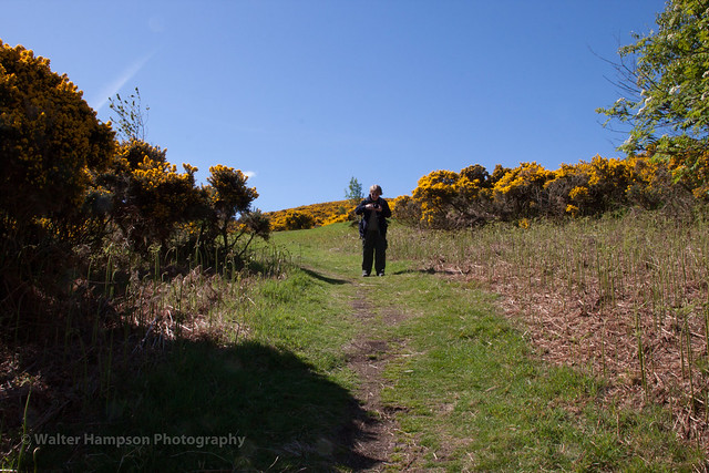
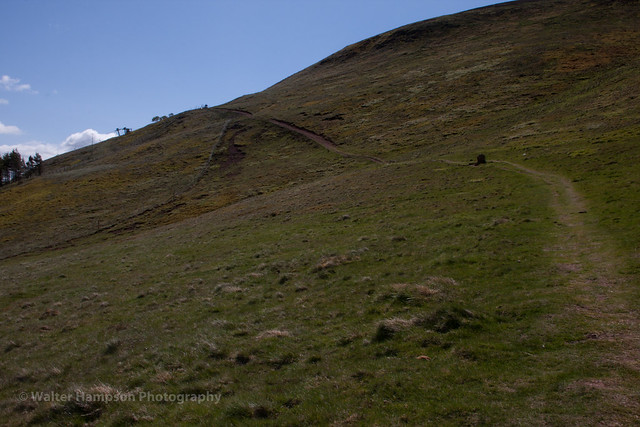
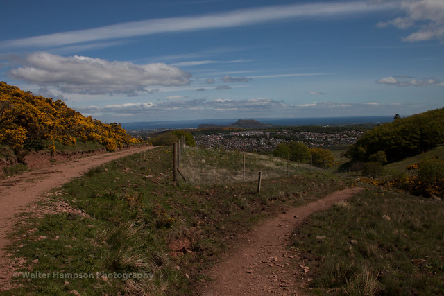
As I said, the initial climb is steep but do-able if you take your time. I am just beginning to enjoy walking and this was my 6th walk but the first in grade two walks. It did come as a surprise how steep the climb was, despite having read the walk guide. Slow and steady pace is needed here, there is no rush. You soon get a reward for the effort you put in climbing Hillend Hill with views like this :
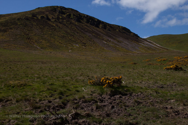
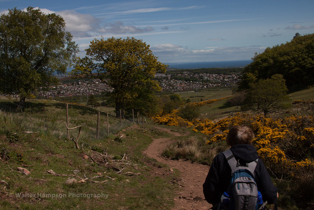
As we neared the top of Hillend Hill I looked towards Caerketton Hill and accepted that fact that I was, as yet, not fit enough to try tackling that climb. Instead we followed the Capital View Walk signs up to the rear of the Ski Slopes, stopping every so often to just enjoy the views on this nice sunny, if a bit windy, day.
[img]%20https://c2.staticflickr.com/8/7798/18256737886_c8e830555a.jpg[/img]
Susan was doing well, but then she is an experienced hill walker and I plodded behind her, stopping every so often to get a photo, and my breath. The suggested time for this walk is 1.5 to 2 hours, which I have no doubt is achievable, but not for a 64 year old novice walker with mobility problems. The best thing as far as I was concerned was just to enjoy the walk and the views as I was not in any rush. Eventually we came to a gate, straight on for Allermuir Hill via Caerketton Hill.
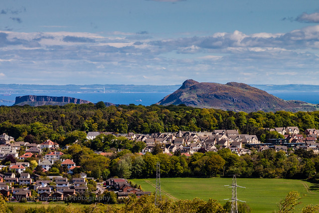
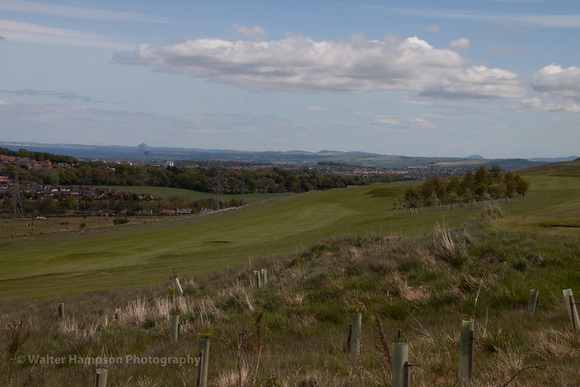
Turn Right for Capital View Walk and follow the well trodden path behind the Hillend Ski Centre. We had started off at 10:10 and had met few people, but by the time we made the change to our present walk the hills were becoming alive with Ramblers, Climbers. I was encouraged by the sight of other elderly, more spritely, walkers striding along and enjoying the walk. There are many reasons to do a walk, from health to enjoyment. For me, I need another reason and that is photography. I take a camera with me wherever I go. Thankfully my partner is aware of this habit and does make allowances for me stopping to get the shot. I was really pleased with the rewards that this walk has for the photographer who makes the effort. The views were stunning and every few yards the views changed.
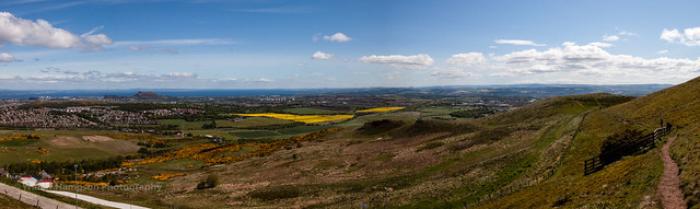 20150530-_MG_5045-Pano by Walter Hampson, on Flickr
  .
.
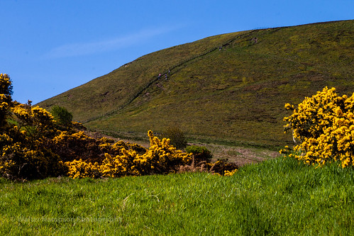
We carried on walking and chatting as we admired the views. Once past the end of the Ski Centre the trail dips down a hill, the path is a bit stony and by looks of it could be muddy in wet weather. I know it was, and is, a popular walk, not only by the amount of people we met, but by the depth the trail has been eroded into the ground.
The narrow path joins a wider path on a level stretch past the Caerketton Craigs....
 ....
....
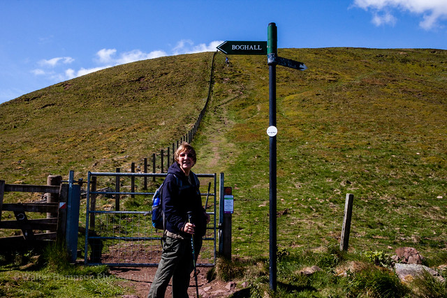
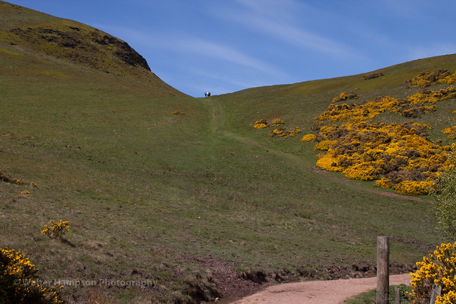
before coming to a cross roads near the Swanston Burn. Here you could take an alternate route to Allermuir Hill via Mullieputchie by taking the left hand path:
 ,
,
However, our route was to the right down a rather steep and stone strewn path.
By the looks of the hoofmarks it is the route the farmer used with his cows. This path does get very muddy in wet weather, thankfully it was dry dirt as we made our way down toward Swanston.
As ever on this walk the views are the walk's rewards to the rambler. We continued down the path, stopping to listen to the birdsong. The path meanders down past Swanston Golf Course,
Before long we came to a gate and the conservation village of Swanston.
To me it was a touch of Norfolk in Scotland. We got here at 12 noon, just in time to sit on one of the two public benches and enjoy a small break and a wee rest before we made our way to Lothianburn then back to Hillend car park. The route from here is straight forward, carry on toward the bottom of the village, turn right at the sign and follow the path until you come to the main road (A702). Turn right and in about quarter of a mile you will see the sign for Hillend Ski Centre.
I enjoyed this ramble, no pressure to beat the guide walk time estimate. The guide shows the route as snow covered, here, on a lovely spring day it was a joy to walk a nice pleasant hill walk.
Link to my Flickr album of the walk https://www.flickr.com/photos/walterhampson/sets/72157653738276995
. As I said, the initial climb is steep but do-able if you take your time. I am just beginning to enjoy walking and this was my 6th walk but the first in grade two walks. It did come as a surprise how steep the climb was, despite having read the walk guide. Slow and steady pace is needed here, there is no rush. You soon get a reward for the effort you put in climbing Hillend Hill with views like this :
As we neared the top of Hillend Hill I looked towards Caerketton Hill and accepted that fact that I was, as yet, not fit enough to try tackling that climb. Instead we followed the Capital View Walk signs up to the rear of the Ski Slopes, stopping every so often to just enjoy the views on this nice sunny, if a bit windy, day.
[img]%20https://c2.staticflickr.com/8/7798/18256737886_c8e830555a.jpg[/img]
Susan was doing well, but then she is an experienced hill walker and I plodded behind her, stopping every so often to get a photo, and my breath. The suggested time for this walk is 1.5 to 2 hours, which I have no doubt is achievable, but not for a 64 year old novice walker with mobility problems. The best thing as far as I was concerned was just to enjoy the walk and the views as I was not in any rush. Eventually we came to a gate, straight on for Allermuir Hill via Caerketton Hill.
Turn Right for Capital View Walk and follow the well trodden path behind the Hillend Ski Centre. We had started off at 10:10 and had met few people, but by the time we made the change to our present walk the hills were becoming alive with Ramblers, Climbers. I was encouraged by the sight of other elderly, more spritely, walkers striding along and enjoying the walk. There are many reasons to do a walk, from health to enjoyment. For me, I need another reason and that is photography. I take a camera with me wherever I go. Thankfully my partner is aware of this habit and does make allowances for me stopping to get the shot. I was really pleased with the rewards that this walk has for the photographer who makes the effort. The views were stunning and every few yards the views changed.
20150530-_MG_5045-Pano by Walter Hampson, on Flickr We carried on walking and chatting as we admired the views. Once past the end of the Ski Centre the trail dips down a hill, the path is a bit stony and by looks of it could be muddy in wet weather. I know it was, and is, a popular walk, not only by the amount of people we met, but by the depth the trail has been eroded into the ground.
The narrow path joins a wider path on a level stretch past the Caerketton Craigs....
.... before coming to a cross roads near the Swanston Burn. Here you could take an alternate route to Allermuir Hill via Mullieputchie by taking the left hand path:
, However, our route was to the right down a rather steep and stone strewn path.
By the looks of the hoofmarks it is the route the farmer used with his cows. This path does get very muddy in wet weather, thankfully it was dry dirt as we made our way down toward Swanston.
As ever on this walk the views are the walk's rewards to the rambler. We continued down the path, stopping to listen to the birdsong. The path meanders down past Swanston Golf Course,
Before long we came to a gate and the conservation village of Swanston.
To me it was a touch of Norfolk in Scotland. We got here at 12 noon, just in time to sit on one of the two public benches and enjoy a small break and a wee rest before we made our way to Lothianburn then back to Hillend car park. The route from here is straight forward, carry on toward the bottom of the village, turn right at the sign and follow the path until you come to the main road (A702). Turn right and in about quarter of a mile you will see the sign for Hillend Ski Centre.
I enjoyed this ramble, no pressure to beat the guide walk time estimate. The guide shows the route as snow covered, here, on a lovely spring day it was a joy to walk a nice pleasant hill walk.
Link to my Flickr album of the walk https://www.flickr.com/photos/walterhampson/sets/72157653738276995
Click to mark this as a great report. Register or Login free to be able to rate and comment on reports (as well as access 1:25000 mapping).
Loch Venachar Forestry Walk - An Amblers Joy
Date walked: 17/04/2015Distance: 7km
Ascent: 210m
Views: 4431
-
WalterH

- Location: Livingston
- Occupation: Retired
- Interests: Photography, Reading, Computing, Walking, Touring Scotland.
- Activity: Ambler
- Mountain: Buachaille Etive Mor
- Place: 1 Edinburgh - 2 Glencoe
- Camera: Pentax / Nikon / Canon
- Ideal day out: Ramble - steady paced walk with camera and with my partner. I love Scotland in all her forms, her mountains, glens and cities. I love to follow a trail of kings and people. I like to photograph her beauty and her scars. I've enjoyed my recent lease of life with gentle walks at Aberlady, St Abbs, Radical Road and Loch Venachar.
- Ambition: Enjoy my retirement
- Filter reports
- Trips: 2
- Distance: 11 km
- Ascent: 413m
- Joined: Apr 16, 2015
- Last visited: Sep 09, 2019
- Total posts: 2 | Search posts
