
 In October this year, as part of a month long rock festival, the best places to see Scotland’s geology were announced. At this point you may well be sitting there with a confused look on your face as you try to picture Ozzy Osbourne shouting Scottish place names into the microphone while raucous guitar riffs and all manner of dazzling stage theatrics reverberate around him. As entertaining as that would undoubtedly be, that’s not the kind of rock festival I’m talking about. This was the Geoheritage Festival, a nationwide celebration of Scotland’s geodiversity. ‘Geodiversity’ a much more commonly used term these days, although it perhaps still suffers from the Cinderella syndrome when put along side its more showy near-namesake, biodiversity.
Biodiversity is commonly defined as the variety and variability of living organisms in a given place. So when we talk about the biodiversity of Scotland we are considering the many thousands of species that live here, from tiny bacteria to fungi to fish, from mice and molluscs to bats, birds and basking sharks. Everything, basically. And in the same way, geodiversity refers to a similarly bewildering variety and variability, but this time in the non-living part of the natural world.
In search of Scotland’s geodiversity. Top: standing outside the hidden Vat. Bottom: the Vat’s narrow entrance
Its common definition is ‘the variety of rocks, minerals, fossils, landforms, sediments and soils, and the natural processes that form and alter them’. That last part about processes is important, especially its avoidance of the past tense, for while it’s easy to see our geological heritage as a done deal, a gift from the past that has no bearing on the present other than gifting us big 3000ft mounds of rock to go climbing over, remember that the processes that have shaped our treasured landscapes are ongoing to this day. They just occur at such a glacial pace that we can barely perceive them, such as the weathering forces of wind, water and temperature, or the imperceptible movements of the earth and molten rock beneath our feet, whose existence is only occasionally betrayed by the occasional earthquake or landslide.
The processes and features of our geodiversity are just as important as biodiversity, because without the non-living element of the natural world we wouldn’t have the living element either. The link between the two can be as glaringly obvious as giving us solid ground to stand on, for plants to grow on, but there are more subtle relationships too. Consider, for instance, that the minerals in soil that are so important for plant growth are derived from pulverised rocks. Without soil, there would be no plants. Without plants, there would be no animals. And without animals, no Ozzy Osbourne. I know, it’s a world of nightmares.
The point I’m labouring here is that geodiversity is underrated and it deserves far more attention than it gets. Fortunately for us, Scotland being a globetrotting land mass that has over the last few hundred million years crossed the equator, sizzled under molten lava, been crushed beneath alpine mountain ranges and eroded into deserts, flooded by tropical seas and ground down by glaciers, well…..suffice to say Scotland has a staggering wealth of geological treasures to explore for a country of its size.
But where on earth does one start? Never fear, the Scottish Geodiversity Forum has scoured 3 billion years of Scottish history so that you don’t have to, and has narrowed our geodiversity down to a small, more manageable selection via ‘the 51 Best Places to see Scotland’s Geology’. Yes, 51 not 50. Evidence, as if it were needed, that Scotland’s geological treasures are so numerous that it’s nigh impossible for the best ones to be reduced to a nice round number.
From Shetland to the Solway, from Skye to Stonehaven, these 51 intriguing sites take in beaches, Neolithic villages, sea stacks, caves, bogs, islands, coires, hills and even whole mountain ranges. Numbered from north to south, from 1 to 51, together they tell the story of Scotland’s journey through deep time. And to give you a wee taster of what’s on offer, last week I paid a visit to No.31 – Burn o’ Vat.
Burn o’ Vat
The Vat is a curious place, tucked away on the edge of the Muir of Dinnet National Nature Reserve in between Ballater and Aboyne. By far the best thing about it is that if there wasn’t a path leading you straight to its door, it could actually be quite difficult to find. Even when you’re just a few metres away you could easily be forgiven for still not knowing it was there, which is pretty impressive for something that measures 18 metres wide, 13 metres tall and looks unlike anything else in Scotland.

Inside the Vat, standing on the pancake floor, under one of the two massive wheel arches.
Fortunately, these days a well-trodden path follows the burn (to which the Vat gives its name) from the Visitor Centre and takes you half a kilometre west to the entrance. But even then, as you approach it you’re probably wearing a quizzical look on your face as you wonder what exactly the path is asking you to do. Initially the burn appears to flow from a wall of rock, but on closer inspection you see it is flowing from a mere slither of a gap in said rock, just a few feet wide. This is the well-concealed entrance, and depending on how much rain has fallen your feet can get a wee bit damp as you clamber up the burn and through the gap, which is in fact a short tunnel.
Even when you’ve seen photos of this place the sudden sense of cavernous space still comes as a surprise. On my first visit it was a genuine ‘wow’ moment, and on my second the reveal was just as exciting. You find yourself standing in a massive cauldron in between two cliff faces. Ferns and other soggy greenery hang from every ledge, and ahead of you on the far side of the cauldron is a steep jumble of rocks down which a small burn tumbles. To the left and the right, on opposite sides of the Vat, are two large semi-circular depressions in the cliff faces, together looking somewhat like the empty wheel arches of a car.
As you walk forwards for a closer look you are then struck by the unusual pancake-flat floor. Made from gravel it is soft underfoot and, on this particular occasion, under a couple of inches of water. The ground seems to be a bit drier under the arches, so you move towards one of them and then turn around to get a fresh perspective. The narrowness and angle of the entrance means it has now disappeared among the massive boulders, which only serves to exaggerate the weird sense of containment or imprisonment.
It’s a bizarre halfway house between a cave and a gorge, and with all the different features fighting for your attention your gaze is drawn in all possible directions. Upwards at the sheer cliffs on either side, sideways to the sculpture-like shapes of the arches, and downwards to the odd pancake at your feet. When I visited last week there was nobody else there, which is a shame because it undoubtedly helps having others milling about in order to give the place a sense of scale. But in either case, you can’t help but just stand and gawp, and ponder what forces could have created such a place.
The Burn o’ Vat – a mere trickle compared to what it was like 15,000 years ago
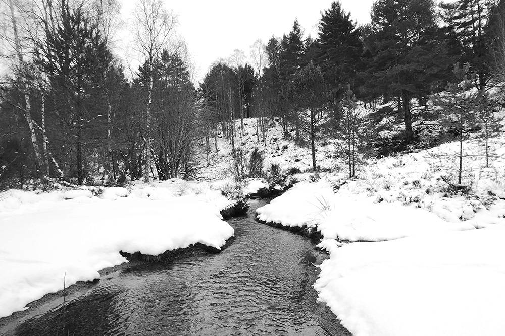
The clues are all around you, of course. The boulders, the cliffs, the arches, they’re all wonderfully smooth in appearance, so it’s a reasonable assumption to make that water must be involved somehow. But up until now you’ve only seen one watercourse in the area – the small and sedate Burn o’ Vat – the one you followed during your walk from the visitor centre, which passes through the Vat and then drains into Loch Kinnord. It’s barely more than a trickle, and so even allowing for a timescale of thousands of years you struggle to see how a burn that small could ever have carved out something so large. But a long time ago the burn was larger. MUCH larger!
The freeze and the thaw
22,000 years ago the climate was much colder and ice covered much of Scotland, but this wasn’t just a thin sheen we’re talking about. At its height, the most recent ice age buried the Cairngorms under glaciers and ice caps 1km thick, but around seven thousand years later the climate had warmed and the ice was melting fast. Massive torrents of meltwater cut channels through and under the ice in search of the easiest way to low ground.
Meltwater rivers flowed freely underneath the Deeside ice, steadily carving out channels in the rock, but it’s believed that one of those meltwater rivers encountered a large obstacle at what is now the Vat. The obstacle might have been a more hard-wearing area of bedrock or a massive boulder, but whatever it was it caused circular eddies in the river’s flow. Such was the force of the melting water that all manner of debris was washed along with the river too – rocks, stones, boulders and ice – and this helped the swirling water to cut away at the rock around it and produce what you see today. It’s actually a common feature of many turbulent rivers worldwide (although usually on a much smaller scale) and is what geologists call a ‘pothole’.
I’ve not found any estimates for how long it might have taken for the Vat to be sculpted out, but most accounts seem to agree that around 1000 years after the melting began in earnest, the ice was largely gone and the meltwater river became more of a trickle. As the flow reduced it was only able to carry smaller pieces of gravel downstream, which gently and steadily accumulated in the pothole and began to fill it in a very even fashion. Some accounts put the depth of gravel at seven metres but I’m not sure anyone knows for certain. It will likely go down quite some way as the turbulence of a pool erodes downwards as well as outwards.
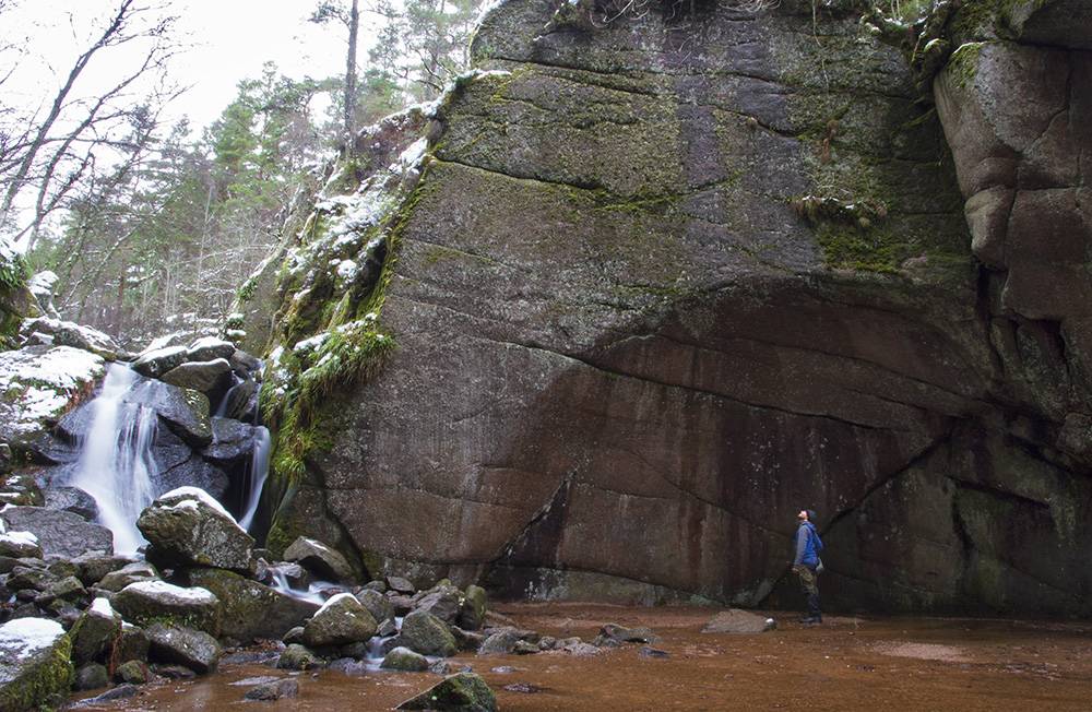
Seen head on, the arches certainly do give the impression of a buried sphere.
Some geologists assert that the bottom section of the pothole is completely spherical in shape, which is certainly hinted at by the wheel arches on either side, as they very much resemble the top half of a sphere visible above the gravel floor. That’s quite a surreal and unsettling realisation to ponder when you’re actually standing there, because it means that rather than standing in a few inches of water on apparently solid ground, you’re in fact standing on the surface of a massive and rather deep pool…..only it happens to filled with gravel as well as water.
Should you find walking on water a totally disconcerting prospect then you can clamber up the side of the waterfall onto dry land, leave the Vat behind and enjoy the circular route that takes you back to the car park via the attractively wooded hillside. Along the way you’ll find a lovely wooden viewpoint that looks out across Muir of Dinnet National Nature Reserve, with stones on the ground carved with single words. One of them simply says:
‘ICE’

A nice place to pause and reflect
I love it. It’s the perfect underscore to the walk, summing up the whole experience in just one word. It invites you to pause and ponder the big questions, concepts, impossible timescales and maybe even the sense of insignificance that your short time in the Vat is likely to have provoked. Such is the power of Scotland’s geodiversity, and happily there’s much more where that came from.
Walkhighlands features a slightly extended Burn o’ Vat and Culblean circular walk.