free to be able to rate and comment on reports (as well as access 1:25000 mapping).
Post-lockdown escape from UK (Episode 2)July 14 - Sept 12, 2020. With Covid-19 restrictions making flights less attractive, a road trip around the Alps and southern Italy was an obvious choice for 2020, with plenty of 1000m
prominence (P1000m) peaks to choose from (Ribus, named after the Indonesian word for 1000, as that’s where the
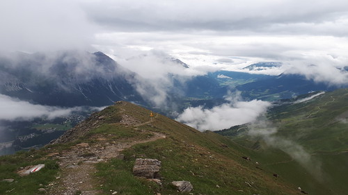
Ribus list started life). When the Britain and France lifted their mutual quarantine requirements, I booked at 2-month Eurotunnel ticket and headed for the Alps, with a long list of possible peaks, and the vaguest of plans. As it turned out, the trip would include 117 P600 peaks including 74 P1000s, five of them P1500m ultras filling gaps in my Europe collection. These high-prominence peaks are often range highpoints and given their dominance they are usually excellent viewpoints. The trip included two spells in Switzerland, the first planned from the start, the second due to the way things evolved.
 Peakbagger 2020 ascents map - Swiss peaks
July 14: After an early morning Eurotunnel crossing I spent most of the day driving across the France, paying the highest tolls of the trip, and after a morning ascent of
Le Roignais 2995m P1028 (described in Episode 1
French Pre-Alps ),
 20200714 Le Roignais: NE couloir
 by
Rob Woodall, on Flickr
crossing into Italy I made a quick afternoon ascent of the rather trivial
Il Mottarone 1491m P1130 en route to Switzerland. The Swiss rules permitted me to travel there, although the British infection rate was rather close to the Swiss limit, and I was unsure what reception I’d get. In fact, the border was unmanned and my only challenge late evening was to obtain a motorway vignette before driving to the next trailhead. My estate car is quite well set up for sleeping, although heavy rain didn’t make for a quiet night. My overall plan was to climb 5 doable Ribus there (i.e. omitting anything not reasonably soloable), before bagging my way eastwards through northern Italy.
July 15. With unsettled weather, steep rocky Pizzo Tambo would have to wait for a few days, but
Monte Tamaro 1962m P1406 was straightforward, with any easy trail leading to a briefly rainy summit;
 20200715 Tamaro: rainy summit
then on the opposite side of road, Monte Gambarogno 1734m P340 was a nice bonus peak before the next band of rain arrived.
Haldensteiner Calanda 2805m P1458 is a 2200m climb from the valley, doable enough, but a paved road can be used to halve this climb, and my task for the afternoon was to obtain a permit. The hotel where Petter bought his, is now apartments. An epark pass was needed – but this required a Swiss mobile phone. A friend with a phone … I texted him my Reg No and he forwarded the epass on to me.
 20200716 Calanda ascent: layered cloud and livestock
 July 16 a pleasant, varied, drizzly ascent led to an impressive rocky summit above a big drop.
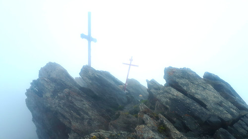 Calanda summit
In the afternoon, grabbing an unexpected weather window, I climbed
Stätzerhorn 2574m P1027, climbing through cloud to enjoy a cloud inversion.
 20200716 Statzerhorn summit ridge: evening clearance
July 17. After a rainy night I drove round to the
Aroser Rothorn 2980m P1348 trailhead, watching the weather radar for an hour until the last of the heavy showers had passed, then in improving weather hiked the fine Welschtobelbach trail,
 20200717 Aroser Rothorn ascent: Welschtobelbach
whence my route climbed past the Ramozhütte to the Erzhornsattel, then via the east ridge to the summit. Except that in poor visibility I followed cairns straight on and spend an unduly exciting hour exploring the wrong ridge!
 Aroser Rothorn ascent: chossy misty off-routeing
Extricating myself from steep choss I regained the trail and was soon up, and quickly down as I had a dinner date with friends.
July 18. The good weather arrived as forecast with
Pizzo Tambo 3279m P1165 my last Swiss peak of the trip (at least, that was the plan). The later-than-usual start worked well, as in mid July the peak still held large snow patches, making my trail-shoe-shod ascent quite interesting, but doable thanks to a good boot trail,
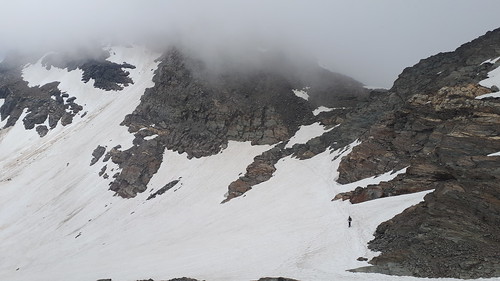 20200718: Pizzo Tambo ascent: snow traverse and cloudy summit
and after attaining the steep rocky summit,
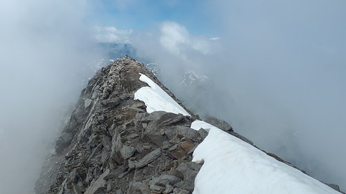 20200718 Pizzo Tambo summit ridge
the snow was soft enough for glissading on the way down.
 Pizzo Tambo descent: looking across Splugenpass to Surettahorn
 Pizzo Tambo descent: Lago di Monte Spluga
 Back in Italy, there was time for a sunset ascent of
Monte di Tremezzo 1700m P962.
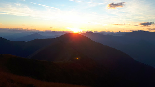 20200718 Monte Tremezzo: sunset over Calbiga
I made my way east via a rich selection of dramatic northern Italy peaks, dodging into central Italy to miss poor weather before joining Lee for a week to climb some harder Dolomites peaks, then bagging the Slovenian Ribus (the Covid restrictions had been lifted by the time I arrived there on August 6), then to central and southern Italy before returning to France on my way back to the UK. I met Lee again for the impressive
Argentera 3297 P1295 and then after a selection of fine peaks in SE France (described in Episode 1:
French Pre-Alps) found myself back in Switzerland! This was due to a combination of being ahead of my (very vague) schedule, Lee having an unexpected free weekend, and Covid-19 regulations meaning that a post-Switzerland week in Germany would count toward the 14-day quarantine period required by the UK.
Sept 3. Crossing from France into Italy,
Monte Nudo 1235m P953 made for a scenic ascent via a slightly scrambly beechwood ridge with lovely views of Lago Maggiore,
 20200903 Monte Nudo: summit view north across Lago Maggiore
 then just over the Swiss border,
Monte San Salvatore 913m P603 was a convenient afternoon objective. Despite having a “mere” 603m of prominence, it’s a fine steep peak with a view of Lago di Lugano to die for – with that fate a little more likely if you tackle it via the via ferrata! Lee reckoned it was straightforward, but he’s younger than me and was even younger when he climbed it.
 20200903 Monte San Salvatore ferrata: halfway view across Lugano
It’s one of the steeper ferratas of my career, with a lack of positive footholds in the lower half, and I was glad of a bench with a view, when I at last joined the crowds at the summit. The summit area also features a display celebrating Swiss railway engineering - ideal for a civil engineer trying to get some feeling back into his arms!
 Monte San Salvatore summit: Funicular railway poster from 1939
Sept 4. In continuing excellent weather I climbed the beautiful
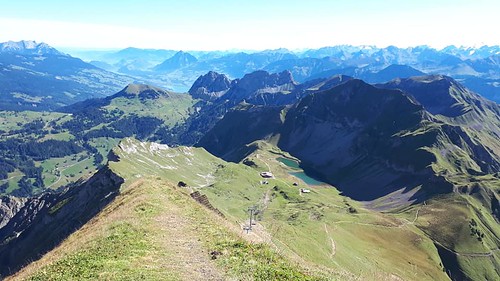
Brienzer Rothorn 2348m P1340 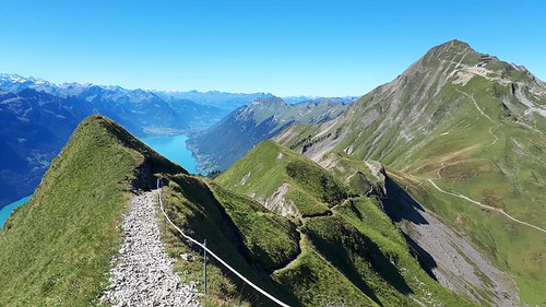 20200904 Brienzer Rothorn from Arnihaagen
- a doable Ribu in the north-east which I’d omitted during my July visit. With a cable car and a rack railway,
 Brienzer Rothorn west ridge and Sörenberg cable car Bergstation
it’s a busy peak, but an ascent on foot from Sörenberg to the north, avoids the crowds for the most part.
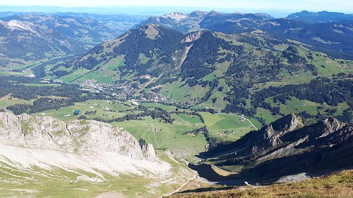 Brienzer Rothorn summit: looking down on Sörenberg trailhead
The summit has a fancy “witches hat” triangulation point,
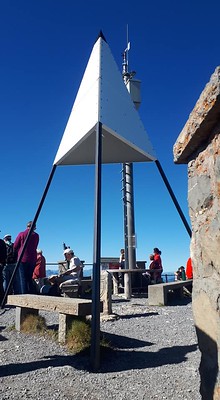 Brienzer Rothorn summit
and a picture-perfect view down on Brienzersee.
 Brienzer Rothorn summit: view across Brienzersee to Berner OberlandArnihaagen 2212m P187
 with its narrow cable-protected ridge makes for a nice little diversion on the way down.
 Brienzer Rothorn summit: view east; Arnihaagen to R
The twin peaks of
Hängst 2091m P775 and
Hächle 2091m P141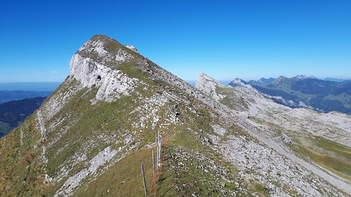 20200904 Hängst with Hächle beyond
involve a short drive down the valley followed by an ascent through stark limestone karst characterised by deep holes and jagged rock.
 Hängst ascent: looking across karst limestone of Schratteflue to Berner Oberland beyond
The summits are poised above impressive cliffs which aren’t visible until just before arrival.
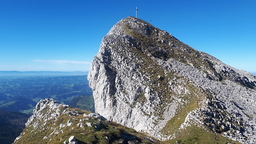 Hangst summit
 Hächle from Heidejoch: shadows lengthening
The ridge between them has a few interesting scrambly moments,
 Hächle W face
 Hächle: scrambly gap near summit
 Hächle: view SE across Schratteflue to Bernese Oberland
and the sun is well on its way down by the time I’m on the descent trail.
 Hächle descent: Brientzer Rothorn and Sörenberg village, early evening
Sept 5.
Titlis 3238m P979 is a big glaciated 3000er
 20200905 Titlis: descending W ridge
which has been largely tamed by the expensive “Rotair” cable car. Lee had been up it before, but the slightly surreal ascent of
Rotstöckli 2901m P41  20200905 Rotstöckli from Rotegg
made a good excuse for a revisit. Thanks to an administrative quirk, this chossy little tower somehow gets to be the highest point in Nidwalden canton (a mere pimple on the side of Titlis - but the latter is the highpoint of the neighbouring Obwalden canton). Lucky for the Canton High Points bagger, it has an unofficial ferrata, actually for the use of workmen pre-emptively setting off avalanches to keep the ski slopes safe. But they don't mind people climbing it.
 On the Rotstöckli's unofficial ferrata above Titlis Gletscher
While Rotstöckli is Nidwalden’s highest point, Bürgenstock 1127m P682 is its most prominent, and made for a varied and scenic afternoon ascent, staying clear of the wet weather advancing from the southwest (it caught me in Germany the next day).
 20200905 Bürgenstock ascent: view SW to Stanserhorn
The Hammetschwand Lift, claimed to be highest external lift in the world, is an alternative way to the top, climbing the peak’s N face (153m, in 1 minute), from the shore of Vierwald-stättersee (Lake Lucerne).
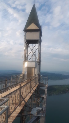 Bürgenstock: Hammetschwand Lift
I then headed to the Bavarian Alps for my last week, returning to Britain on Sept 12. An excellent trip exceeding expectations, with an ever changing plan, including many good peaks, some challenging, most of them easy, especially those in southern Italy.
Route descriptions, GPX route files and Facebook photo albums for the individual peaks, are linked from within this report and can also be accessed via my Peakbagger.com ascents page for 2020
