free to be able to rate and comment on reports (as well as access 1:25000 mapping).
28 Aug 2020. This peak (2789m with 1541m
prominence – one of the
Alps Ultras) was climbed as part of a two month peakbagging trip which included ten days in the French Pre-Alps. The limestone Devoluy massif, between Grenoble and Gap, is a superb area,
 Devoluy: OpenTopoMap
and the Grande Tête is one of the best peaks I’ve ever climbed, in terms of scenery and general entertainment value. Including the Chatières (cat flaps!) route upped the interest immensely.
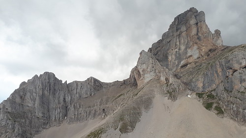
The peak looked good from Le Tabor the previous afternoon,
 20200827: Le Tabor: view S: Tête du Collier, Pice de Bure, Grande Tête de l'Obiou
 by
Rob Woodall, on Flickr
and as I drove south towards the trailhead, its cliffs were glowing in the dying rays of the day.
 20200827: Grande Tête de l'Obiou from N, sunset
The approach is via a good quality unpaved forest road, and I slept in my car at the trailhead, with a couple of vehicles already there.
Next day, rain was forecast in the afternoon, and an exposed route on limestone is no place to be in wet conditions, so I started at first light, with the peak's spectacular creamy sunlit cliffs in full view.
 20200828: Grande Tête de l'Obiou: E face at dawn, from trailhead
The trail starts to the R immediately after a No Unauthorized Vehicles sign,
 Obiou trailhead
then follows a gentle grassy spur before skirting R of cliffs,
 Obiou approach: traverse
to enter a grassy bowl.
 Obiou approach: sheep grazing near Le Pas du Vallon
The cliffs look superb in the morning light,
 Obiou E face, early morning
as I choose the L fork and cross a scree slope, the path bending R to join the other variant which climbs Obiou’s steep grassy NE spur
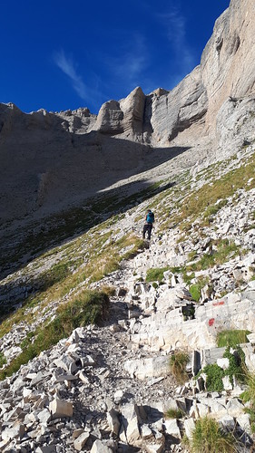
 Obiou ascent: NE couloir traverse
then turns L to make a rising traverse of steep rocky slopes into the NE couloir. A French couple are the only others on the peak today, and we leapfrog each other on the trail as I make frequent photo stops.
 Obiou ascent: NE couloir traverse
 Obiou ascent: Petit Obiou cliffs
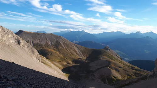 Obiou ascent: view N over Crête de la Laisse
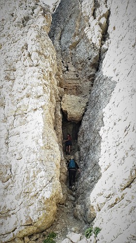
A steep but straightforward paint-marked scramble leads to a col. From here the normal route climbs to pass L of the vertical E face, with the Chatières route forking R at a cairn, making an upward traverse beneath the cliffs, with no upward route apparent!
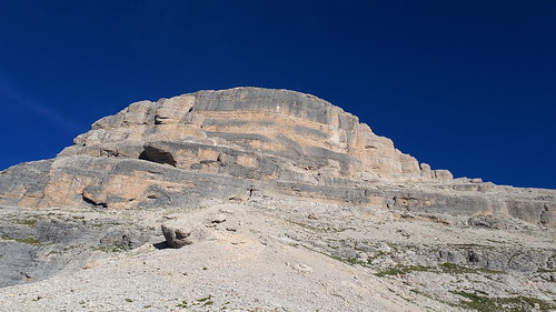 Obiou E face: Chatières route traverses R along foot of cliffs; Normal route sneaks round to the L
The first "cat flap” is a short tunnel,
 Obiou ascent: Chatières route: first tunnel
 Obiou ascent: Chatières route: first tunnel: view NE
with a steep scramble out of the far side. The route continues to traverse R uphill along the foot of the cliff,
 Obiou: Chatières route: view S; Pic de Bure
 Obiou: Chatières route: tower
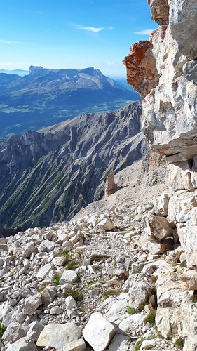 Obiou: Chatières route: view S: Pic de Bure
to reach a corner with a huge drop below. It's possible (rather exciting) to edge L round this corner, but this is NOT THE ROUTE !
 Obiou: Chatières route: N face - not the route !
Just then, the French couple arrive,
 Obiou: Chatières route: ledge on Obiou NE prow
and they know the way. I'm following Ivan Deiros' GPS track which is pretty accurate and I would have worked it out, in time, but informed company is very welcome on a route like this (no paint marks). The route doubles back sharp L at this point, follows an easy ledge,
 Obiou: Chatières route surprise: ledge then R and into the vertical gully (!)
then enters an impossible-looking gully.
 Obiou Chatières route: chockstone
The squeeze under the chockstone is fun.
 Obiou: Chatières route: chockstone climb
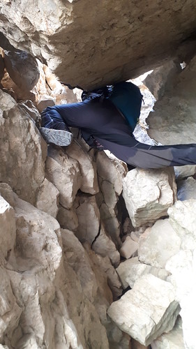 Obiou: Chatières route - the thrutch !
My companions helpfully take my backback through the hole ahead of me. To my surprise there’s then an escape L from the impossible gully, past a boulder squeeze (they climb over; I force myself through the gap), then after a R turn through another cleft, I pop out at the summit. I grab some food: they of course have a proper pique nique including cheese knife. I marvel for a while at the scenery,
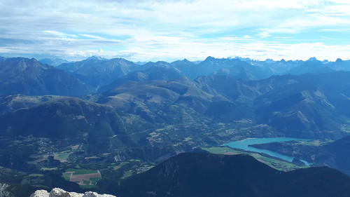 Obiou summit: view NE: bad weather on its way
picking out a few familiar shapes from the tangle of peaks, including Pic de Bure and Tête du Collier, which I'll climb a few days later,
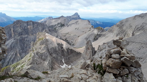
 Obiou summit: view E: Pierroux - Collier ridge
 Obiou summit: Pic de Bure, Le Grand Ferrand
 Obiou summit: view S: Pic de Bure, Tête de Lapras, Le Grand Ferrand
then start to head down.
 Obiou descent: view S: Tête de Lapras, les Agards, Le Grand Ferrand
My companions soon pass me as I search for the start of the route, then the path is obvious as it skirts the foot of cliffs
 Obiou descent: S face traverse
 Obiou descent: S face
and passes beneath overhangs.
 Obiou descent: S face
Following the GPS track, I return a favour as it's my companions' turn to get off route, and we leapfrog our way down.
 Obiou descent: Petit Obiou and Lac du Sautet
 Obiou: descent to col
Once back down in the couloir,
 Obiou: descent to NE couloir
 Obiou descent: Petit Obiou
 Obiou descent: view N towards Crête de la Laisse; yesterday's Le Tabor and Le Taillefer in background
I take their NE spur route and they take my scree path (I notice at least one tumble

quite harmless). Directly below, the Crête de la Laisse is beckoning,
 Obiou descent: Crête de la Laisse
a sharply defined but straightforward grassy ridge, and I take in its 82m re-ascent as a half-hour detour. It's a superb viewpoint for Obiou.
 Obiou: looking up at NE prow; Petit Obiou to L
 Obiou: NE prow
 The rain is on its way, with grey showery curtains adding drama to the peaks to the E,
 Obiou descent: view E: Crête de la Laisse, Pierroux-Collier ridge, bad weather approaching
but I’m on safe ground now,
 Obiou: gentle ridge descending to trailhead
 Obiou trailhead in centre of picture
and apart from a light shower, I make it to the trailhead with half an hour to spare. Ironically, I take a little tumble skipping down the last few metres to the road, confirming how slippery the limestone can be when damp.
 Obiou E face from trailhead at midday
I was delighted to have been able to fit in this superb peak before the rain arrived. I found a hotel in Grenoble in which to sit out the 36-hour weather front before continuing my peakbagging journey. This part of France is highly recommended, with peaks for all abilities.
Route description and GPX route is at
https://www.peakbagger.com/climber/ascent.aspx?aid=1470479. The ascent is part of
Episode 1 of my Summer 2020 trip.
