walkhighlands

This board helps you to share your walking route experiences in England and Wales... or overseas.
Warning Please note that hillwalking when there is snow lying requires an ice-axe, crampons and the knowledge, experience and skill to use them correctly. Summer routes may not be viable or appropriate in winter. See winter information on our skills and safety pages for more information.

Canada - Beautiful Buller Pass

Canada - Beautiful Buller Pass


Postby ChrisW » Tue Aug 18, 2015 11:16 pm

Date walked: 17/08/2015

Time taken: 4

Distance: 16.4 km

Ascent: 691m

5 people think this report is great.
Register or Login
free to be able to rate and comment on reports (as well as access 1:25000 mapping).

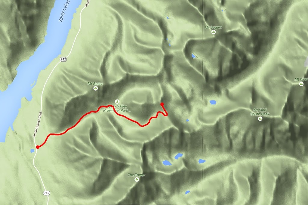
Buller Pass has been on my 'saving' list for some time, saving until I have a two car scenario so I can make a fantastic traverse from Highway 742 (Smith Dorrien Trail) to Highway 40 (Kananaskis Trail) via Ribbon Lake. The truth is I never have a two car scenario and asking Sarah to make a drive of hundreds of kilometres so I can have a nice hike seems a bit selfish (to say the least) so today when I felt like having an easy day, I decided to make the hike to Buller Pass from the west. I can follow this at some point with a hike to Ribbon Lake from the east so I can at least see the whole traverse albeit in two sections.

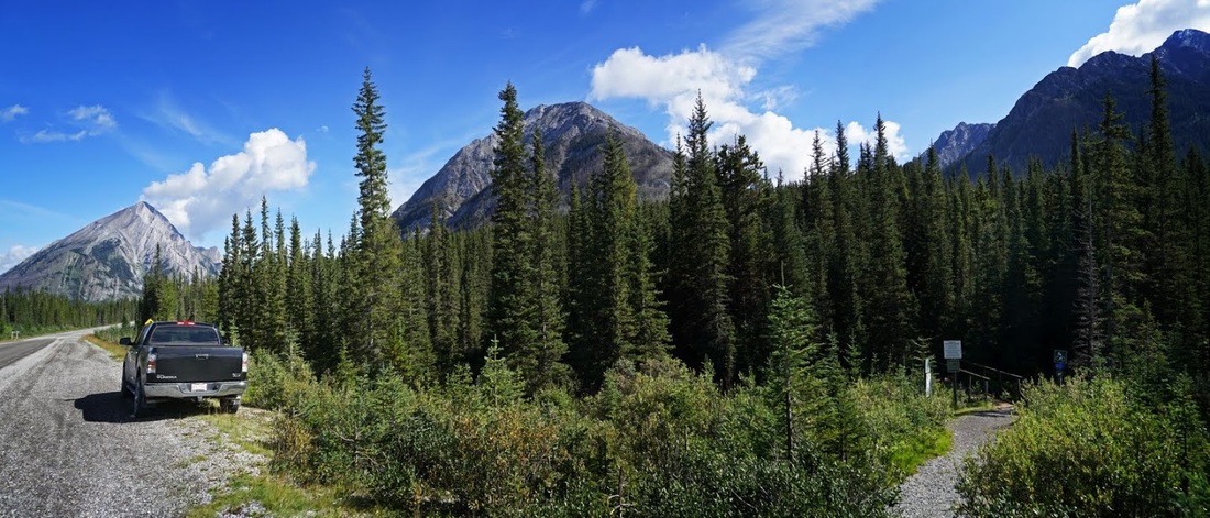
Finding the car park for the hike is easy, simply take highway 742 out of Canmore heading south, check your odometer reading as you pass the Canmore Nordic Centre and travel a further 31km where you will see a signed turning for 'Buller Mountain'. Park in the first car park on the right as you enter, the trailhead is well signposted directly back across the main highway.

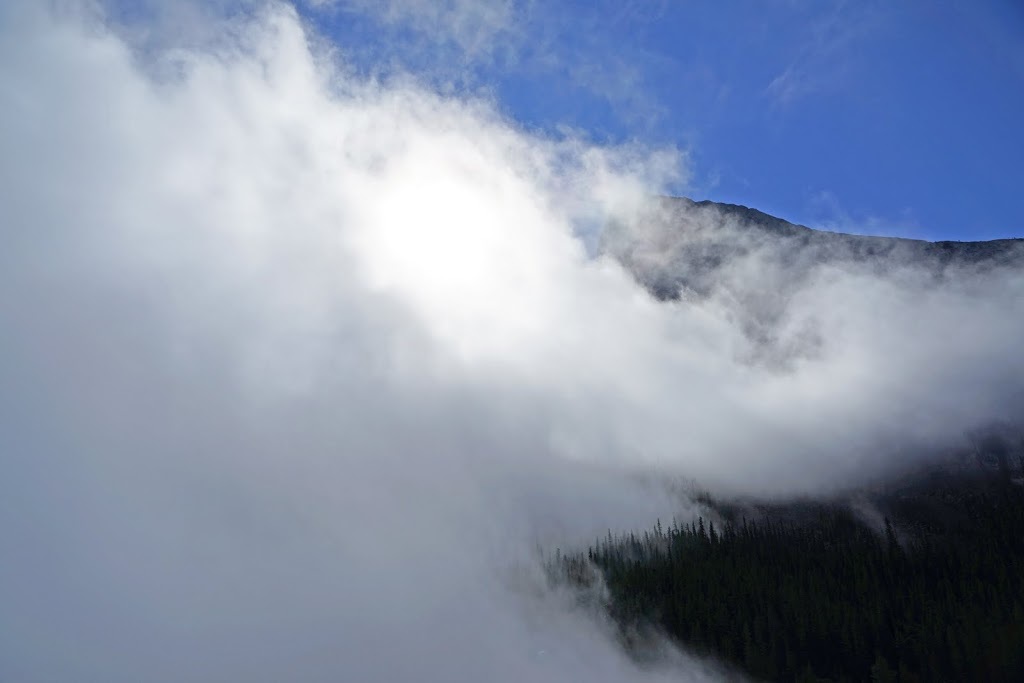
The day began a little worryingly as thick fog hung in the mountains as I approached the Bow Valley Corridor from the prairies, but I could see a few peaks poking out of the top and kept going hoping that altitude would clear the issue. I had begun to doubt my assumption as I reached the top of Whitemans Gap above Canmore when I emerged from the fog as abruptly as I'd entered it 40 km back along the TransCanada highway. In the shot below Ha Ling Peak emerges from the mist as the sun tries its best to break through. Image

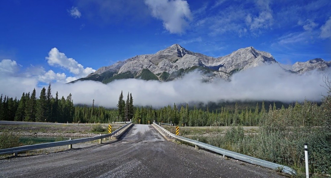
With another 7 km on the clock I pass over the canal that moves water from Spray Lakes Reservoir to the hydro power plant above Canmore and stop to catch a shot of the fog bank drifting below Goatview Peak, there's no sign of the predicted cloudy skies above it and it looks like the drive out was worthwhile after all.
Image

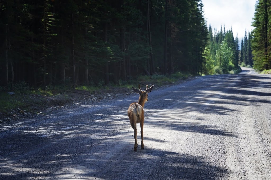
The gravel road leads away alongside Spray Lakes Reservoir for another 20 km, as I'm winding through forest a small herd of deer cross over in front of me and I stop to let them pass, they were all does with the exception of this guy who 'guarded' their crossing and then continued standing there after they were clear just to show me who's boss around here, it made me smile.
Image

When I got to the trailhead I saw a family parked by the roadside just setting off along the trail, I stopped to say hi and the guy explained that the car park had a load of broken glass in it and he decided to back out and park by the roadside. After taking a peek I did the same (beer bottles galore) It's very rare to find such vandalism out in Kananaskis but when you do it is always in tourist season.

I took my time preparing and saw nobody else as I sat on the tailgate getting suited and booted, the shot below shows highway 742 looking north (back to Canmore) and the trailhead to the right. Image

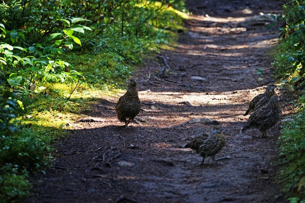
The hike starts with a small bridge crossing a melt-water run off before plunging into incredibly dense forest. The trail is very well worn and remains so throughout the whole hike making it impossible (even for me) to wander off course unintentionally. I'd only been walking a short time when I came across this ptarmigan family on the trail, as they were in no hurry to get off it I stood and watched them for a while.
Image

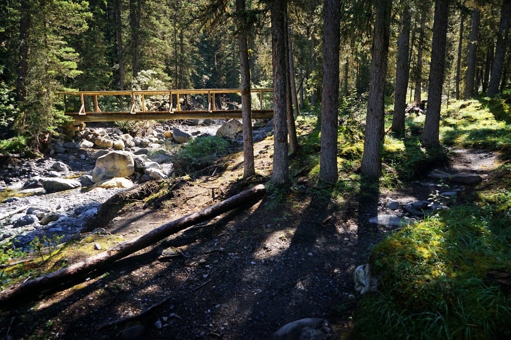
The second bridge crossing Buller Creek is a new construction, probably replacing a flood damaged predecessor. Every time I see these new constructions I'm reminded that there's no charge to enter the park (Kananaskis) and there's no charge for parking either and I am genuinely grateful for the hassle free 'arrive and get walking' result (as opposed to stopping to pay park fees, digging round for change for a meter, finding you have the only coin in the world that the meter doesn't recognise etc.)
Image

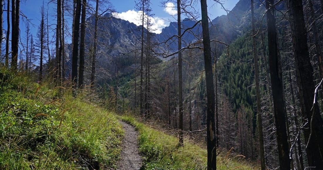
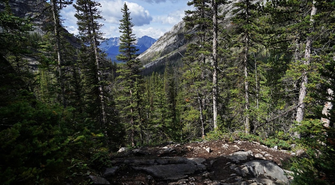
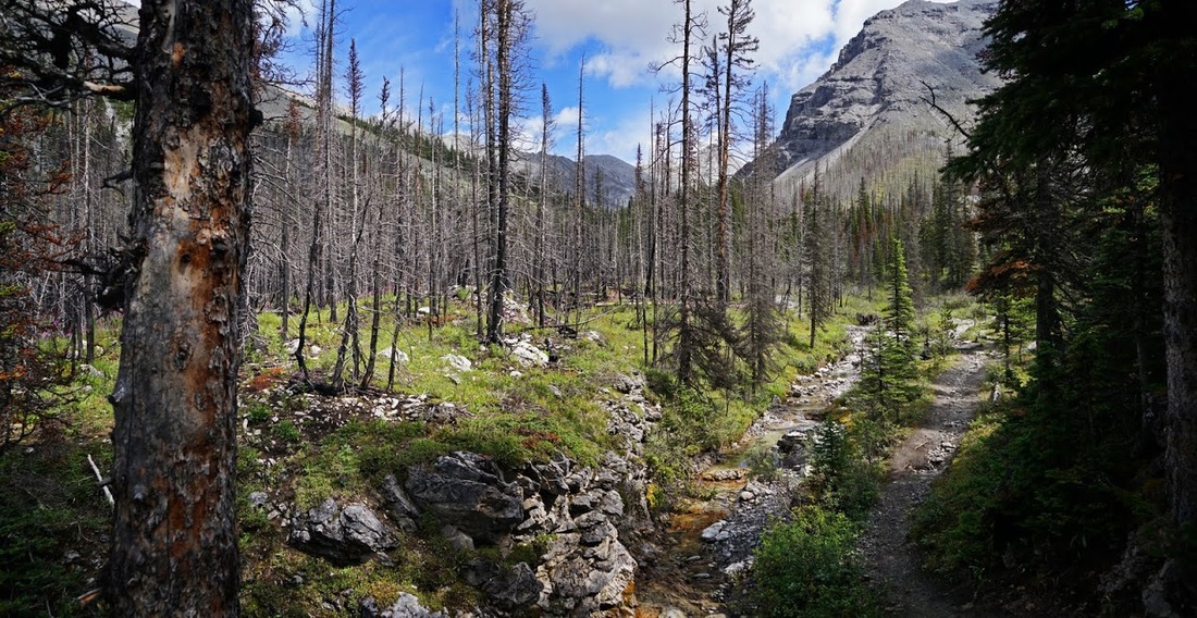
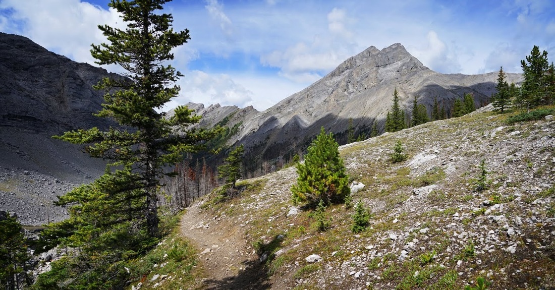
The dense forest remains for quite a while before a short ascent above the creek brings me into a fire damaged area (not recent) which allows light in and offers a glimpse of the northern flanks of Mt Engadine
Image

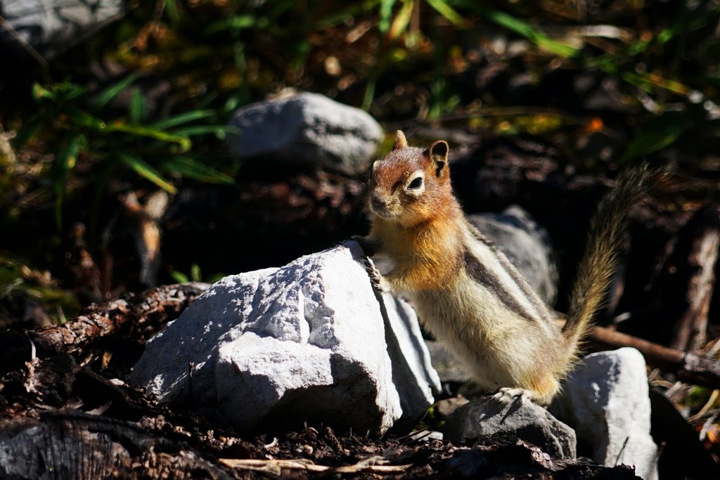
The fire damaged area is absolutely overrun with golden mantled ground squirrels, I've never seen so many in one location before and obviously its only a matter of time before one strikes a pose I can't resist.
Image

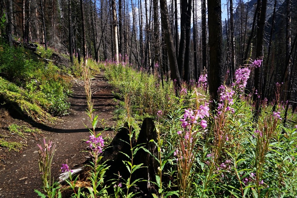
The area is awash with the appropriately named 'fireweed' (or rosebay willowherb in the UK) which is the perfect example of a 'pioneer species' which quickly establishes itself on open areas where light is abundant. Interestingly as trees and shrubs return the fireweed dies out but its seeds remain in the soil awaiting the next forest fire or clear cut operation when they will germinate again.
Image

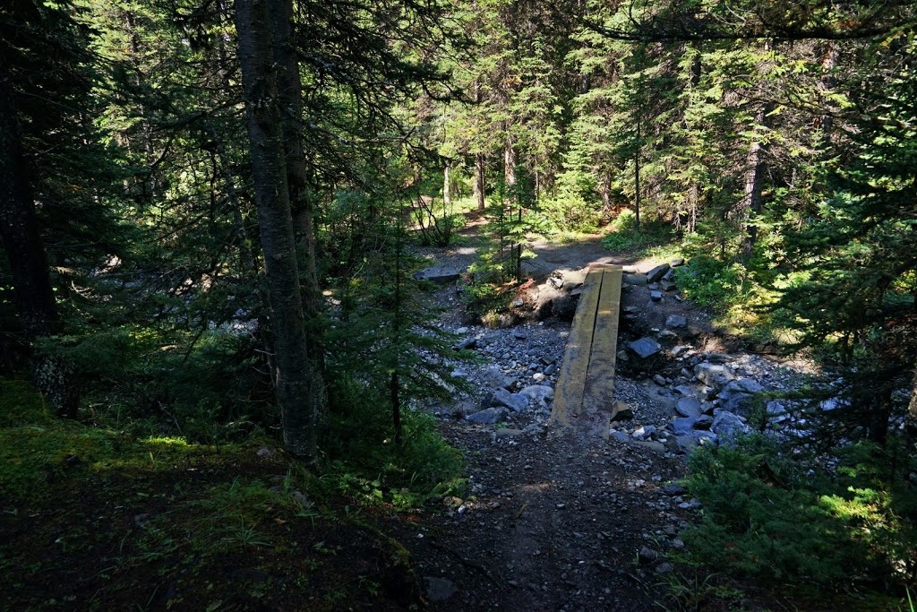
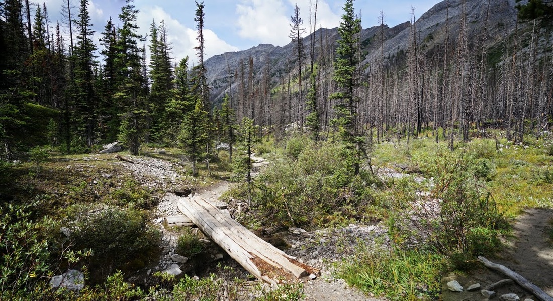
After the fire damaged area the trail falls again to a lower dense forest once more where bridge number 3 comes into view, this is the 'split log' type of bridge typical of trails out here where a single trunk is cut vertically and pinned across a creek with the flat 'cut' side facing upward, a simple and effective bridge that is easily replace after flooding.
Image

I am well into the hike before any real ascent begins and even when it does it's not the usual 'mountain goat' slope I've come to expect of almost every kananaskis hike. As I round a curve and stop to take photos looking back down the route so far I meet a ranger who is heading down. The unsung heroes of the trail out here these guys haul tools along the trials and cut fallen trees, rebuild bridges, create diversionary routes where necessary and generally maintain the trails. We have a nice long chat sat on the bank at the trail side and I tell him about the glass in the car park, he wasn't aware as he was dropped off at the trailhead this morning and says he'll have it sorted today. Before he sets off again to meet his ride at the trailhead I remind him how grateful we hikers are for his efforts and he seems genuinely uplifted as he wanders off.
Image

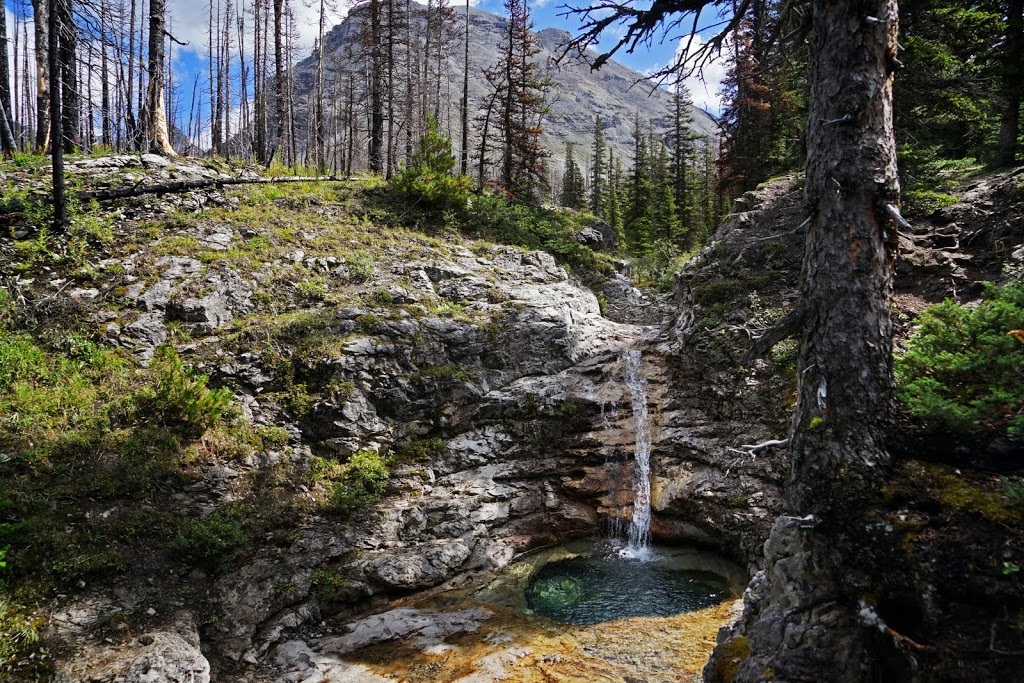
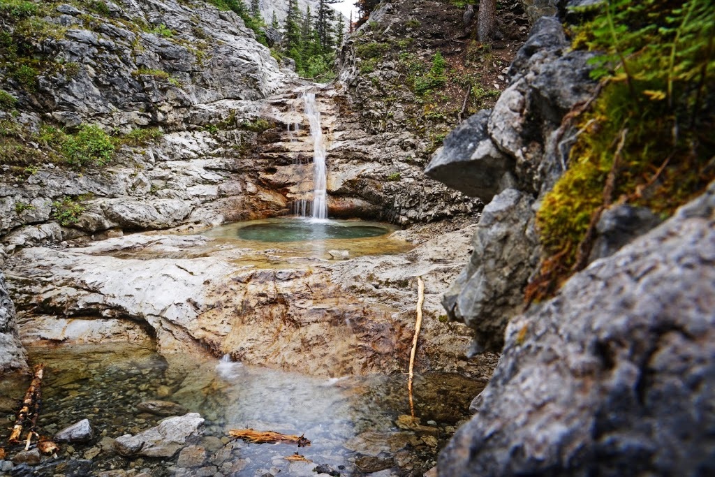
Soon after my meeting with the ranger I reach another fire damaged area and hear a waterfall away to the left of the trail, I took a very short detour and found a lovely little plunge pool at the base of a small waterfall, I considered scrambling down for more photos but decided to keep going for now and think about it on the return.
Image

I return to the trail above the falls where it runs beside the creek feeding the falls, I can't help but think that the trail and the creek become one during the melt season.
Image

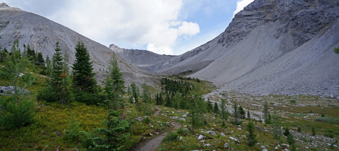
The last of the bridges (No.4) looks to have been here the longest and by the look of it won't be here much longer. There is a trail here leading off to North Buller Pass but it is hardly used and almost indistinct from its surroundings now. This shot looks back down the valley already travelled
Image

Once across bridge No.4 the valley opens out with light streaming in through the burnt out remnants of the forest. The long ridges at the northern end of 'The Tower' make up the vertical wall to the right which curves around into the centre of the frame.
Image

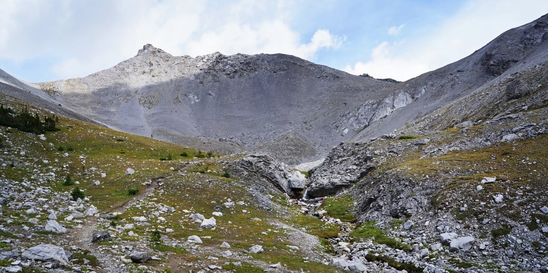
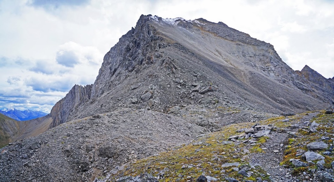
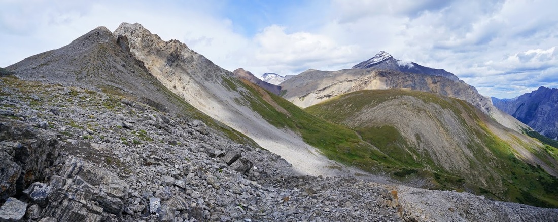
The ascent has flattened out again and I'm soon curving around the flanks of the unnamed lump that sits between north and south Buller Pass stopping to look back to the summit of Mt Buller with the long shadows of 'The Tower' covering its south facing wall.
Image

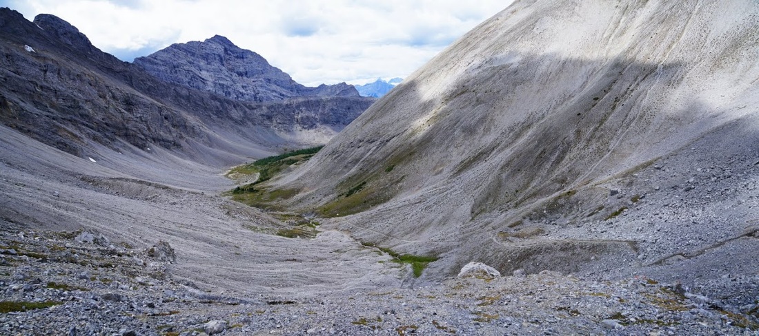
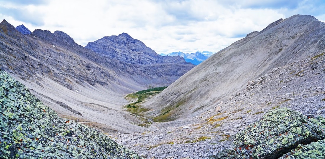
The trail now points directly up the valley toward the headwall and I get my first open view of Buller Pass, the massive walls making up the northern ridges of 'The Tower' still fill the frame to the right and the unnamed lump between the two Buller Passes is to the left.
Image

The trail drops back down to the valley floor and curves around the unnamed lump where I can now see the family of four who left as I arrived slowly making their way up the twisting trail to the pass (they are the black specks in the centre of the frame below)
Image

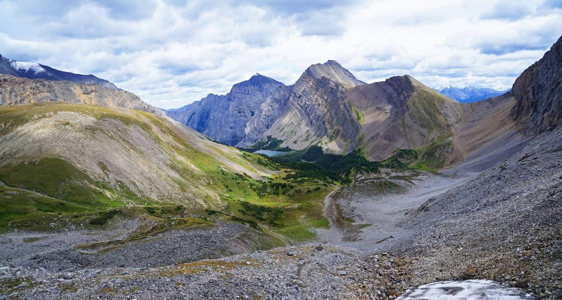
As I begin my ascent of the final stage which is about 300m of vertical scree ascent over 800m of distance I find myself catching the family very quickly, so much so that I can hear one of the two teenage girls bemoaning the whole hiking thing and its futility "we're just going to turn round and go back down again....I don't see the point". I decide to stop and take a few shots back down the valley until the 'domestic' is sorted.
Image

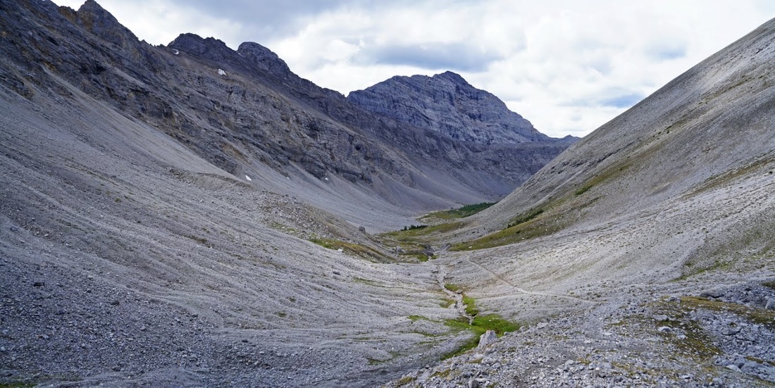
The family are steady on this last ascent and the girls have had enough by the look of it but its a very narrow scree trial and it would feel ignorant to barge past on the last section, so I hold back again and grab another shot of the valley showing the long curve around the unnamed lump on the right.
Image

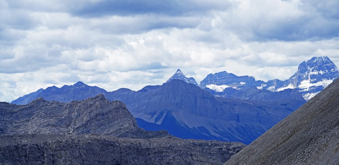
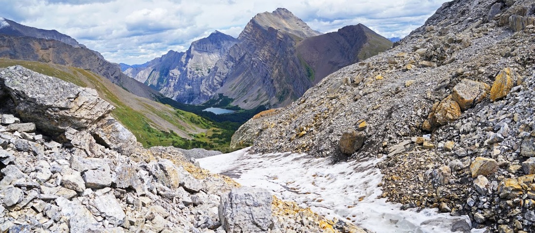
From here I can get a zoomed shot over Mt Turbulent to Cone Mountain (centre frame) and Beersheba Peak (right) with its summit still hidden by low cloud which now fills the sky to the west.
Image

The family finally make the last push for the summit and I follow just far enough behind to avoid contact (for fear of becoming embroiled in the domestic) until I make the pass and get my first view of Ribbon Lake in the valley beyond. Last nights snow still lingers in a few places and, as with all mountain passes above 8000 feet the wind is howling over here and it's very cool (Buller Pass is at 8150 feet)
Image

To the north is Mt Bogart still holding on to last nights snowfall and in front of that is the green valley that leads back around to North Buller Pass. I thought about making a circuit but there seems to be little to be gained in terms of views and it requires a full descent and re-ascent which I don't fancy today, instead I head to the bump on the left of shot.
Image

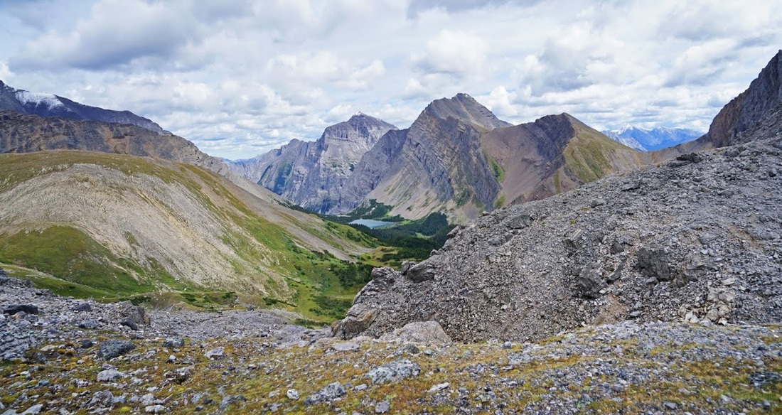
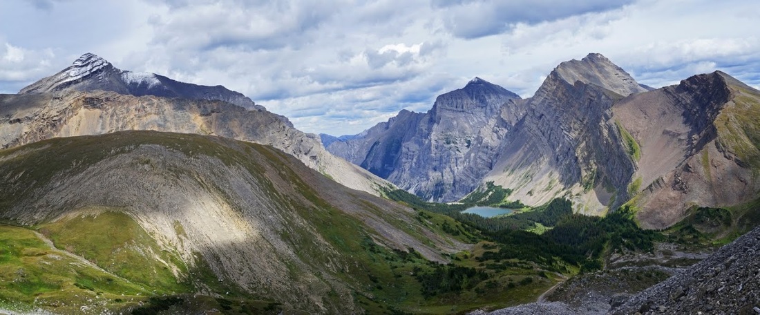
From the top of the rocks I get a fantastic view back down the valley and beyond to the distant ranges in Banff National Park.
Image

From the rocks looking over to Ribbon Lake numerous routes are visible, the one I really like the look of is continuing down beyond Ribbon Lake and out to highway 40 for a total of around 25km, and having done this first part I fancy it even more. There is also a hike to the right up the light orange scree to Guinns Pass, then down to highway 40, it would mean more ascent but shorten the route by using Galatea Creek trail to exit saving about 8km. Lastly there's the circular route from south to north Buller Pass through the green valley to the left of shot.
Image

From my lofty perch I see the family of four packing up and heading back down the trail so I give them a cheery wave and get one in return, maybe they're in better spirits now they are going back down. Anyway, this allows me to drop back down to the spot they had stopped to rest in, so I can gain a different angle on the view.
Image

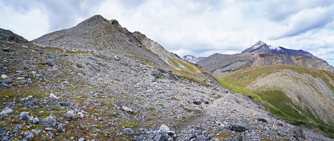
Up to my right is the very end of the ridge that reaches all the way from 'The Tower' along the ascent valley to the pass, and even it still holds some of last nights snow.
Image

I tucked myself into a nice cosy spot above some permanent snow and looked out over the stunning valley as I took my only short rest of the day. The dominating mountain to the right of Ribbon Lake is Mt Kidd behind which is Kananaskis Village and the wonders of highway 40. The dark snow covered peak is the main summit of Mt Kidd and the peak bathed in sunlight is the south summit. The distant snow covered lump visible through Guinns Pass is The Wedge which I scrambled up a few weeks ago.
Image

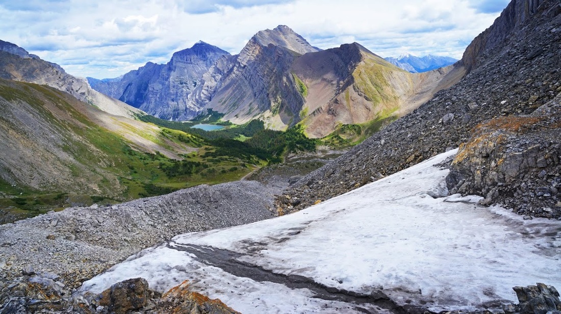
To my left are the lumps I wandered around on until the fighting family left the scene, just visible beyond them is 'Red Peak' which is a hike/scramble I've been considering, the distant snow covered peak through the gap is Wind Mountain and to the right, again with snow covering, is Mt Bogart.
Image

As the skies darken and a few showers drift past I take a last look at this wonderful valley which I'm absolutely sure I will return to, at least once. I would like to bring Sarah up here when her foot is fixed but I suspect the snow will prevent that this year and I'm not entirely sure I want to haul a picnic all this way.
Image

On the way out I scrambled down to that little plunge pool at the bottom of the waterfall and found it to be surprisingly deep (about 4 feet) I lingered a while taking pics before wandering out through the dense forest the way I'd wandered in.
Image

For anyone seeking a fairly easy hike to a wonderful location, this is it, I'm surprised there weren't more people here; it's close to a large town and well signed, it's also still tourist season. I can only assume the morning fog put people off and you won't hear me complaining about that. This is a beautiful hike and one I look forward to returning to.
Image
User avatar
ChrisW
Rambler
 
Posts: 4941
Munros:18   Corbetts:5
Fionas:3   
Sub 2000:6   
Joined: Jan 25, 2011
Location: Cochrane- Alberta - Canada

Re: Canada - Beautiful Buller Pass

Postby dav2930 » Wed Aug 19, 2015 10:28 pm

What a wonderful report. An absorbing narrative containing lots of interesting information. As for your photos, they're stunning (I'd be interested to know what camera you use). Some great wildlife shots too - love the golden mantled ground squirrel. Didn't realize you have ptarmigan over there! A lot of the fir trees don't look too healthy though; is that the effect of acid rain do you think? Cone Mountain and Beersheba Peak look absolutely magnificent. Fantastic stuff Chris. :clap:
User avatar
dav2930
Ambler
 
Posts: 1618
Munros:244   Corbetts:14
Fionas:18   Donalds:56
Sub 2000:1   Hewitts:164
Wainwrights:214   Islands:2
Joined: Feb 13, 2015
Location: Cumbria

Re: Canada - Beautiful Buller Pass

Postby ChrisW » Thu Aug 20, 2015 5:30 am

dav2930 wrote:What a wonderful report. An absorbing narrative containing lots of interesting information. As for your photos, they're stunning (I'd be interested to know what camera you use). Some great wildlife shots too - love the golden mantled ground squirrel. Didn't realize you have ptarmigan over there! A lot of the fir trees don't look too healthy though; is that the effect of acid rain do you think? Cone Mountain and Beersheba Peak look absolutely magnificent. Fantastic stuff Chris. :clap:

Thanks Dav, this one wasn't as exciting as my usual jaunts out here but it's a cracking hike all the same. The ptarmigan really surprised me when I first saw them a few years ago around kananaskis lake, turns out there's thousands of 'em out here :shock: I think the trees might be suffering from pine beetle, the forest fire was a controlled burn in an effort to kill off the beetles, I don't think they've had enough time yet to determine success or failure, they're having a real battle with that particular bug out here.

These shots are taken with my Sony A7r and Sony FE 24-240mm Lens. combined these two give me almost the same results as my 5DIII and 28-300mm lens for about a third of the weight so it has become my 'hiking camera' but if I'm going out specifically taking photos I still use the Canon, probably more to do with old habits than anything :lol:
User avatar
ChrisW
Rambler
 
Posts: 4941
Munros:18   Corbetts:5
Fionas:3   
Sub 2000:6   
Joined: Jan 25, 2011
Location: Cochrane- Alberta - Canada

Re: Canada - Beautiful Buller Pass

Postby Alteknacker » Thu Aug 20, 2015 9:54 am

Brilliant report and pics, as usual, Chris; (and I see that you're still making heavy use of that Photoshop blue... :lol: )

The plunge pool pic brought back some pleasant memories of my childhood in the Yorkshire Dales, where we would go to pools like this to swim in Summer. It looks sooooooooo inviting, but I guess it's pretty chilly, given the altitude.

I never fail to be gobsmacked/astonished/astounded by the amazing mountains you show :shock: . I particularly like the zoomed shot over Mt Turbulent to Cone Mountain and Beersheba Peak (Eiger North Face, surely...???) and the pics looking down the valley towards Mt Kidd. Really wonderful.

Looking at the map, it seems like there might be possibilities for circular routes? But with precipitous rock faces all around, I imagine one would have to be very careful indeed...
User avatar
Alteknacker
Scrambler
 
Posts: 3473
Munros:176   Corbetts:33
Fionas:1   
Hewitts:264
Wainwrights:118   
Joined: May 25, 2013
Location: Effete South (of WIgan, anyway)

Re: Canada - Beautiful Buller Pass

Postby johnkaysleftleg » Thu Aug 20, 2015 3:08 pm

Looks a nice easier walk, the other side of the pass looked truly stunning and a just reward for any effort expended. Hope the girl understood why they had to climb up there eventually.
User avatar
johnkaysleftleg
Hill Bagger
 
Posts: 3341
Munros:25   Corbetts:11
Fionas:11   Donalds:3
Sub 2000:7   Hewitts:172
Wainwrights:214   Islands:8
Joined: Jan 28, 2009
Location: County Durham

Re: Canada - Beautiful Buller Pass

Postby ChrisW » Thu Aug 20, 2015 6:25 pm

Alteknacker wrote:Brilliant report and pics, as usual, Chris; (and I see that you're still making heavy use of that Photoshop blue... :lol: )

The plunge pool pic brought back some pleasant memories of my childhood in the Yorkshire Dales, where we would go to pools like this to swim in Summer. It looks sooooooooo inviting, but I guess it's pretty chilly, given the altitude.

I never fail to be gobsmacked/astonished/astounded by the amazing mountains you show :shock: . I particularly like the zoomed shot over Mt Turbulent to Cone Mountain and Beersheba Peak (Eiger North Face, surely...???) and the pics looking down the valley towards Mt Kidd. Really wonderful.

Looking at the map, it seems like there might be possibilities for circular routes? But with precipitous rock faces all around, I imagine one would have to be very careful indeed...

Cheers Alteknacker, those pools are bloody freezing, so much so that I wonder how they're still liquid sometimes, but I still like a paddle in em :lol:

The choice of hikes/scrambles around here can be overwhelming at times. I did consider a circular route on this one around the two passes but couldn't be bothered as there seemed to be little to be gained and to be honest I find the physical effort out here much more demanding than home so don't take it on if it doesn't look to have some decent reward :wink:
johnkaysleftleg wrote:Looks a nice easier walk, the other side of the pass looked truly stunning and a just reward for any effort expended. Hope the girl understood why they had to climb up there eventually.

Thanks JK, this was just what I needed on the day and the view was incredible for such a steady plod....not sure that girl ever 'got it' they didn't stick around very long at all :roll:
User avatar
ChrisW
Rambler
 
Posts: 4941
Munros:18   Corbetts:5
Fionas:3   
Sub 2000:6   
Joined: Jan 25, 2011
Location: Cochrane- Alberta - Canada

Re: Canada - Beautiful Buller Pass

Postby dav2930 » Thu Aug 20, 2015 7:33 pm

ChrisW wrote: Thanks Dav, this one wasn't as exciting as my usual jaunts out here but it's a cracking hike all the same. The ptarmigan really surprised me when I first saw them a few years ago around kananaskis lake, turns out there's thousands of 'em out here :shock: I think the trees might be suffering from pine beetle, the forest fire was a controlled burn in an effort to kill off the beetles, I don't think they've had enough time yet to determine success or failure, they're having a real battle with that particular bug out here.

These shots are taken with my Sony A7r and Sony FE 24-240mm Lens. combined these two give me almost the same results as my 5DIII and 28-300mm lens for about a third of the weight so it has become my 'hiking camera' but if I'm going out specifically taking photos I still use the Canon, probably more to do with old habits than anything :lol:


Thanks for the info Chris. A straightforward hike like that must have made a nice change from your usual hair-raising scrambles! :lol: Hope the battle against the pine beetles is won in the end.

Just shows how good the Sony A7r is with that lens. I recently bought a Sony A3000 (with standard kit lens) and I must say I'm very pleased with the results it gives (the only drawback is the low res. screen/viewfinder). My usual walking camera, though, is a Panasonic TZ 27 which ain't bad for a compact. You're obviously a more serious photographer than I am! Thanks again.
User avatar
dav2930
Ambler
 
Posts: 1618
Munros:244   Corbetts:14
Fionas:18   Donalds:56
Sub 2000:1   Hewitts:164
Wainwrights:214   Islands:2
Joined: Feb 13, 2015
Location: Cumbria

Re: Canada - Beautiful Buller Pass

Postby trailmasher » Fri Aug 21, 2015 12:12 pm

Stunning report and images Chris :clap: :clap: . Such a diversity of landscape along this route, one of your best yet :clap: . From forest to scree to mountains what an amazing walk that must have been and views to die for. Beautiful colours in the hard landscape but shame about the damage to the forest area :( . The touch of snow adds to the mountains feeling of height and remoteness. Again, what a cracker :D .
User avatar
trailmasher
Mountaineer
 
Posts: 1302
Munros:13   
Hewitts:179
Wainwrights:214   
Joined: Nov 26, 2014
Location: Near Appleby - Cumbria

Re: Canada - Beautiful Buller Pass

Postby ChrisW » Sat Aug 22, 2015 5:12 am

trailmasher wrote:Stunning report and images Chris :clap: :clap: . Such a diversity of landscape along this route, one of your best yet :clap: . From forest to scree to mountains what an amazing walk that must have been and views to die for. Beautiful colours in the hard landscape but shame about the damage to the forest area :( . The touch of snow adds to the mountains feeling of height and remoteness. Again, what a cracker :D .


Cheers TM, I really enjoyed this hike I might even have a bash at it in winter though I suspect avalanche might be a significant risk here then :shock:
User avatar
ChrisW
Rambler
 
Posts: 4941
Munros:18   Corbetts:5
Fionas:3   
Sub 2000:6   
Joined: Jan 25, 2011
Location: Cochrane- Alberta - Canada

Re: Canada - Beautiful Buller Pass

Postby scoob999 » Sun Aug 23, 2015 4:18 pm

Nice one :clap:

There's something weird about walking through a burnt out forest, we done one near Fi's mums and passed one in Oz it's nice to see the new growth coming through though but seems such a waste :(

I hear you've had a bit of snow :shock: I hope it's not gonna stop you walking
User avatar
scoob999
Munro compleatist
 
Posts: 1708
Munros:143   Corbetts:222
Fionas:151   Donalds:89+52
Sub 2000:145   Hewitts:27
Wainwrights:7   Islands:22
Joined: Aug 8, 2011
Location: Birnam/Dunkeld. i think?

Re: Canada - Beautiful Buller Pass

Postby ChrisW » Mon Aug 24, 2015 1:19 am

scoob999 wrote:Nice one :clap:
There's something weird about walking through a burnt out forest, we done one near Fi's mums and passed one in Oz it's nice to see the new growth coming through though but seems such a waste :(
I hear you've had a bit of snow :shock: I hope it's not gonna stop you walking


Cheers Scoob, yeah we've had a pile of snow, all the big stuff has a real coating on top but I don't think it will stay long, we're forecast 7 days of sunshine now so I'll check out a foothills hike tomorrow and get back to the better stuff later in the week :wink:
User avatar
ChrisW
Rambler
 
Posts: 4941
Munros:18   Corbetts:5
Fionas:3   
Sub 2000:6   
Joined: Jan 25, 2011
Location: Cochrane- Alberta - Canada

Re: Canada - Beautiful Buller Pass

Postby Riverman » Mon Aug 24, 2015 8:26 am

Great photos Chris. I might have to look at the A7. A Ricoh GR is my preferred hiking camera. The fixed lens is great but it would be nice to be able to zoom or mount longer lenses. Love the shot to the cone shaped summit. They look like hard, unforgiving peaks. You're so lucky to have all this on your door step.
User avatar
Riverman
Mountaineer
 
Posts: 283
Munros:60   Corbetts:5
Fionas:1   
Hewitts:87
Wainwrights:4   Islands:4
Joined: Dec 31, 2013
Location: Belgium

Re: Canada - Beautiful Buller Pass

Postby ChrisW » Tue Aug 25, 2015 3:11 am

Riverman wrote:Great photos Chris. I might have to look at the A7. A Ricoh GR is my preferred hiking camera. The fixed lens is great but it would be nice to be able to zoom or mount longer lenses. Love the shot to the cone shaped summit. They look like hard, unforgiving peaks. You're so lucky to have all this on your door step.

Thanks Riverman, you can't go wrong with the A7r (well the A7r II now) the second version makes it complete and at 40 mp it grabs some serious detail, it also does 4k video (for those so inclined) all in all it's a nice bit of kit (the purpose built 24-240mm lens is perfect for hiking too)
User avatar
ChrisW
Rambler
 
Posts: 4941
Munros:18   Corbetts:5
Fionas:3   
Sub 2000:6   
Joined: Jan 25, 2011
Location: Cochrane- Alberta - Canada

Re: Canada - Beautiful Buller Pass

Postby litljortindan » Tue Aug 25, 2015 9:33 pm

Great stuff. I take it gravel road means <20mph? Much of that needed for accessing these hills generally?
User avatar
litljortindan
Ambler
 
Posts: 2389
Munros:154   Corbetts:67
Fionas:29   Donalds:1
Sub 2000:47   Hewitts:12
Wainwrights:10   
Joined: Dec 11, 2011

Re: Canada - Beautiful Buller Pass

Postby ChrisW » Wed Aug 26, 2015 7:30 pm

litljortindan wrote:Great stuff. I take it gravel road means <20mph? Much of that needed for accessing these hills generally?


No mate, gravel roads here are 90kmh (55mph) they need to be because they go on for hundreds of kms, they're well maintained (even in winter) when they are ice roads.....which are great fun :wink:
User avatar
ChrisW
Rambler
 
Posts: 4941
Munros:18   Corbetts:5
Fionas:3   
Sub 2000:6   
Joined: Jan 25, 2011
Location: Cochrane- Alberta - Canada

5 people think this report is great.
Register or Login
free to be able to rate and comment on reports (as well as access 1:25000 mapping).


Can you help support Walkhighlands?


Our forum is free from adverts - your generosity keeps it running.
Can you help support Walkhighlands and this community by donating by direct debit?


Return to Walk reports - Outside Scotland

Who is online

Users browsing this forum: No registered users and 9 guests