free to be able to rate and comment on reports (as well as access 1:25000 mapping).
This report may be of use to those visiting Iceland with the aim of exploring some of the scenery.
But, these are short walks - not challenging hikes and climbs (of which there are plenty...)
I've also added a few practical hints and tips at the end for anyone thinking of visiting Iceland.
Snaefell peninsulaThis finger of land north-west of Reykjavik is amazingly scenic. it's dominated by the 1400m ice-capped volcano Snaefell - a mountain I have my eye on if I ever return to Iceland.
 Untitled
 by
Half Man Half Titanium, on Flickr
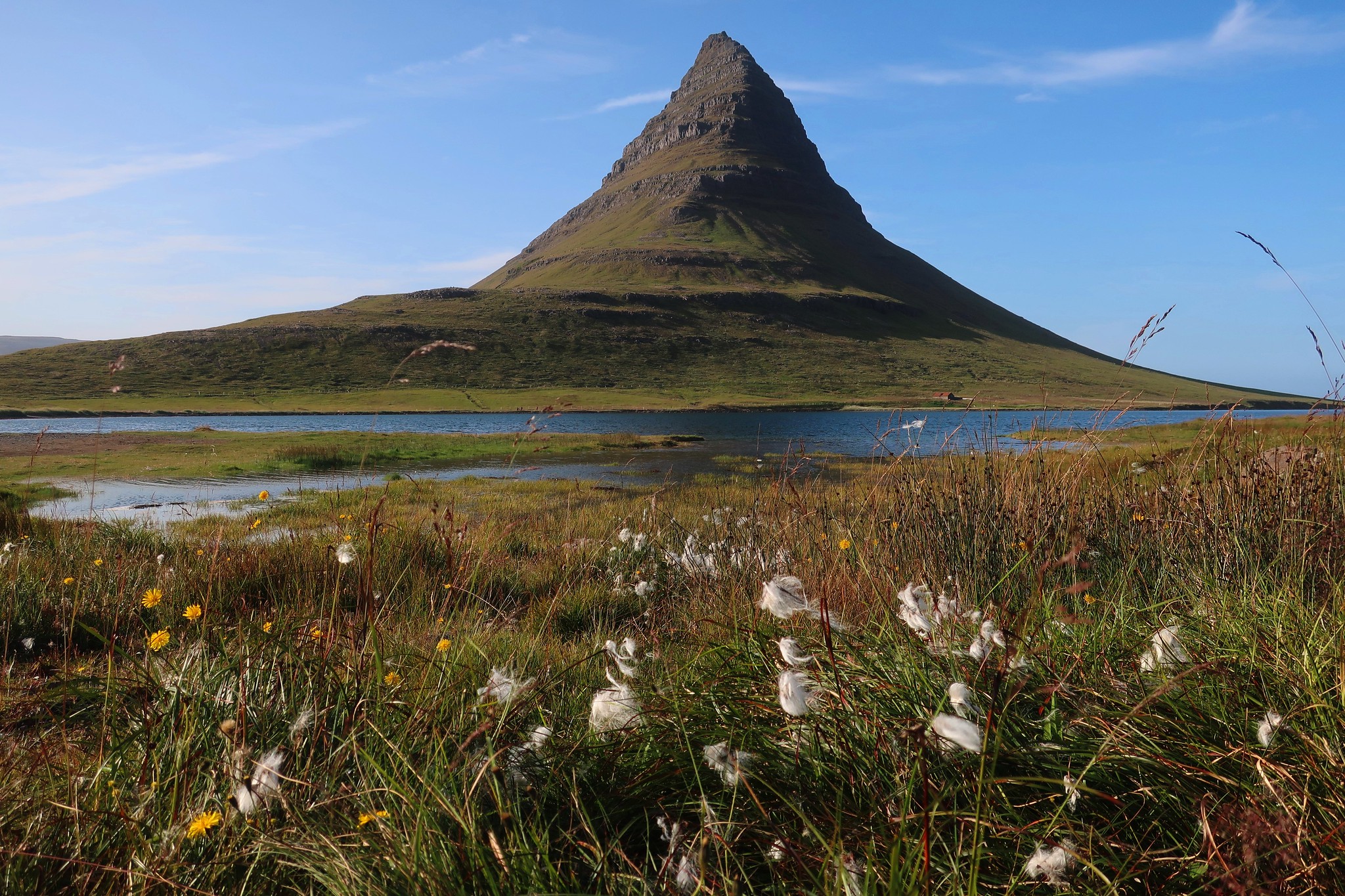
However, the most often photographed (but rarely climbed) peak is Kirkjufjell, which has an Assynt-ish look to it.
 IMG_1006
 by
Half Man Half Titanium, on Flickr
A beautiful coastal walk starts at Arnastapi, a small fishing village surrounded by sea-cliffs and flower meadows - this is the view from above the tiny harbour.
 IMG_4498
 by
Half Man Half Titanium, on Flickr
The area is alive with seabirds (many of the walkers are birdwatchers). This Arctic tern and chick were sitting in the village car park as if they were waiting for a bus.
 IMG_0050
 by
Half Man Half Titanium, on Flickr
A path leads from the car park past a statue of the local legendary giant Bardur. The surrounding meadows are are a carpet of colour. The peak in the background of this shot is Stapafell, a satellite of Snaefell.
 IMG_0049
 by
Half Man Half Titanium, on Flickr
From there it is just a short step to the coast on top of the cliffs. This natural hollow was said to be Bardur's bath.
 IMG_0051
 by
Half Man Half Titanium, on Flickr
The path then turns south along the cliff tops and across a bridge over this idyllic stream. On the other side of the bridge, it falls to the sea in a waterfall.
 IMG_4282
 by
Half Man Half Titanium, on Flickr
No idea what this is
 Untitled
 by
Half Man Half Titanium, on Flickr
There are great coastal views every step of the way along the path. The basalt geology has parallels in Skye and Northern Ireland. But the extreme complexity of the coastline and the intricate rock formations (and all the wild flowers) put me in mind of Pembrokeshire.
 Untitled
 by
Half Man Half Titanium, on Flickr
 IMG_4427
 by
Half Man Half Titanium, on Flickr
 IMG_4418
 by
Half Man Half Titanium, on Flickr
 IMG_4473
 by
Half Man Half Titanium, on Flickr
A redwing (winter visitor to UK) and one of the rock arches.
 IMG_4462
 by
Half Man Half Titanium, on Flickr
After a while, the grass and flowers ended abruptly, and a little valley wound its way between lumpy lava flows.
 IMG_4404
 by
Half Man Half Titanium, on Flickr
Snaefell and Stapafell from the lava flows.
 IMG_4376
 by
Half Man Half Titanium, on Flickr
More botany, this time on the lava
 IMG_4421
 by
Half Man Half Titanium, on Flickr
The overhanging cliffs are populated everywhere with seabirds.
 IMG_0052
 by
Half Man Half Titanium, on Flickr
The path leads on to another fishing village, Hellnar, but we turned back. You could make a full day of it by starting in Hellnar, walking to Arnastapi were there are cafes or picnic spots for lunch, and then returning to Hellnar.
On our return walk we saw that the last wisps of cloud had cleared from Snaefell.
 Untitled
 by
Half Man Half Titanium, on Flickr
A natural harbour - easy to imagine the Viking longships pulling in here
 IMG_4492
 by
Half Man Half Titanium, on Flickr
Finally, we went over to the beach at Olafsvik. The sand here appears to be from feldspar-based rock rather than basalt.
 IMG_1001
 by
Half Man Half Titanium, on Flickr
 IMG_1003
 by
Half Man Half Titanium, on Flickr
South coastEast of Hvolsvöllur (setting of Njal's Saga, and a good base for exploring south and central Iceland) there is a great variety of dramatic scenery along the south coast and inland. The coastal region below the ice-capped volcanoes Eyjafjallajökull (of 2010 flight disruption notoriety) and Mýrdalsjökull is lined with enormous cliffs, punctuated by deep valleys with patches of fertile farmland, and there are glimpses of the glaciers above.
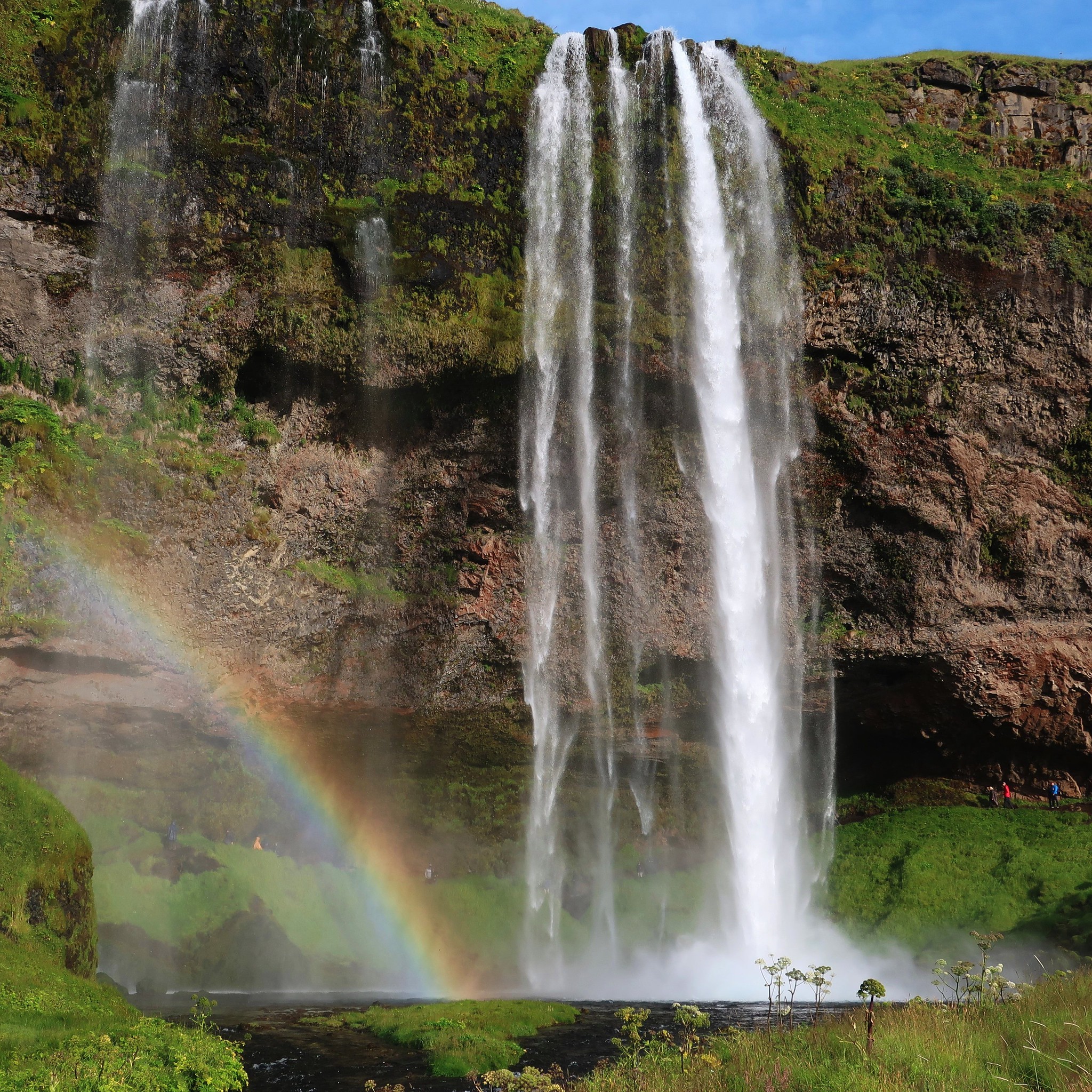
There are some superb waterfalls here. The first two are on the 1 highway near the turn-off for Landeyjahöfn, the purpose-built port for the Vestmannaeyjar ferry, and can both be visited by a short pleasant walk. The southern fall, Seljalandfoss, can easily be spotted when driving east along the 1. It's a beautiful sight.
 03 Mar
 by
Half Man Half Titanium, on Flickr
You can walk behind the waterfall into a wide cavern.
 Untitled
 by
Half Man Half Titanium, on Flickr
Icelandic horses at Seljalandfoss.
 Untitled
 by
Half Man Half Titanium, on Flickr
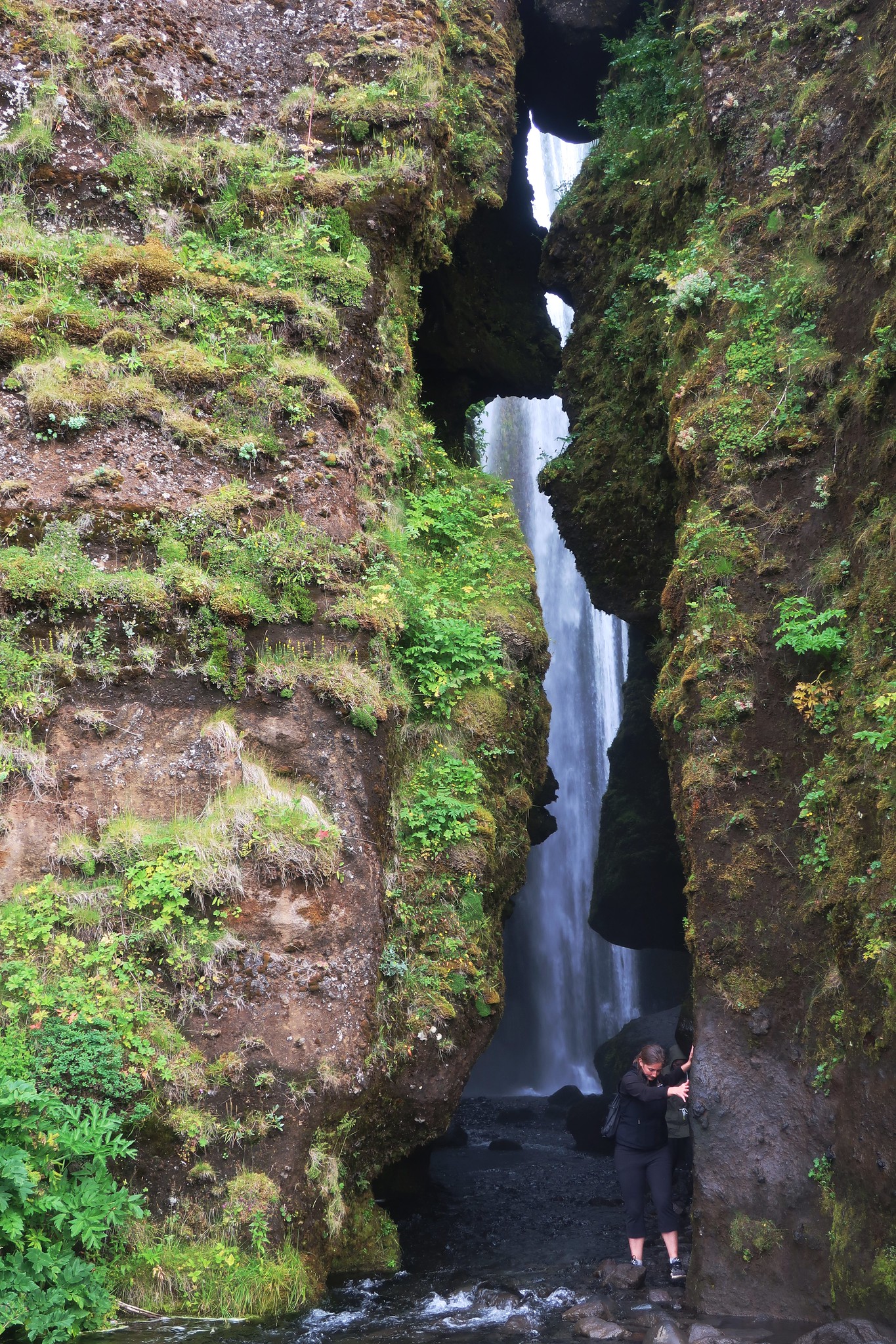
The second waterfall, Gljúfrabúi, is hidden among the crags. Even from the mouth of its slot-like canyon, only parts of it can be seen.
 Untitled
 by
Half Man Half Titanium, on Flickr
To see it properly is a little adventure. You have to walk into the ravine to where it widens out into a hidden amphitheatre.
 Untitled
 by
Half Man Half Titanium, on Flickr
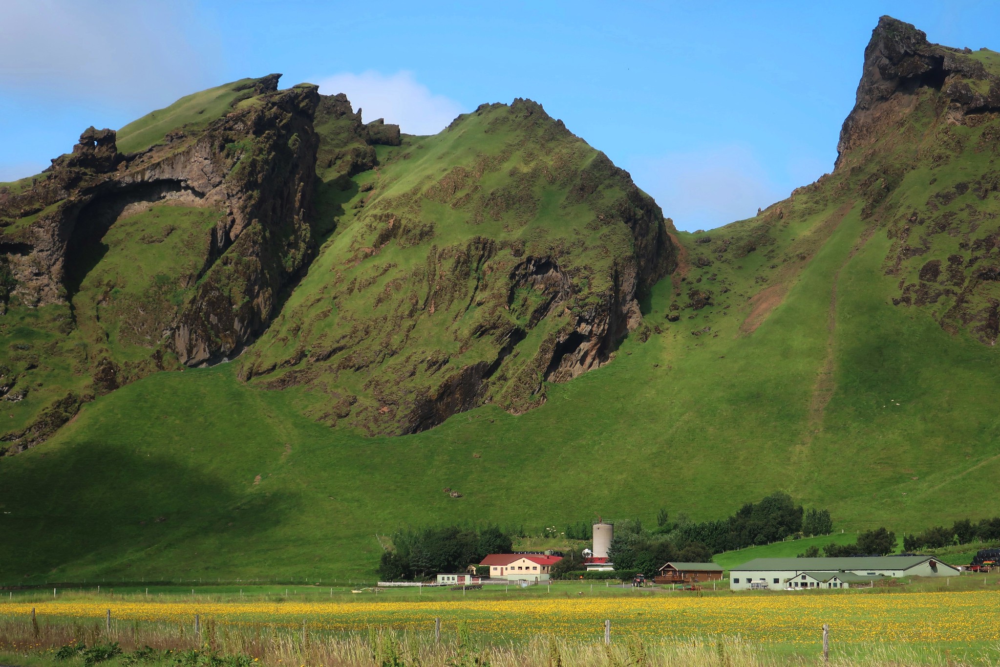
Further along the 1, look out for a car park from which a short walk leads to the turf-roofed houses built into caves in the rock outcrop Drangurinn. These date from around the ninth century, the time of the settlement of Iceland and the Sagas.
One of the turf-roofed houses
 IMG_2001
 by
Half Man Half Titanium, on Flickr
From Drangurinn here there is a view across some beautifully green pastures, to farms framed by crags.
 IMG_2002
 by
Half Man Half Titanium, on Flickr
In the next of these fertile valleys is another iconic waterfall, Skógafoss.
 Untitled
 by
Half Man Half Titanium, on Flickr
There is a cluster of tourist-related buildings here including a museum, and a trail leading to another, hidden waterfall, Kvernufoss. This area is also the start of the high-level trail, the Fimmvörðuháls hike, which leads between the Eyjafjallajökull and Mýrdalsjökull icecaps to the Þórsmörk valley. This was far beyond our ambitions, but looks like a stunning route.
Instead, we headed east along the coast to Reynisfjara beach, which has some good caves and basalt formations.
 Untitled
 by
Half Man Half Titanium, on Flickr
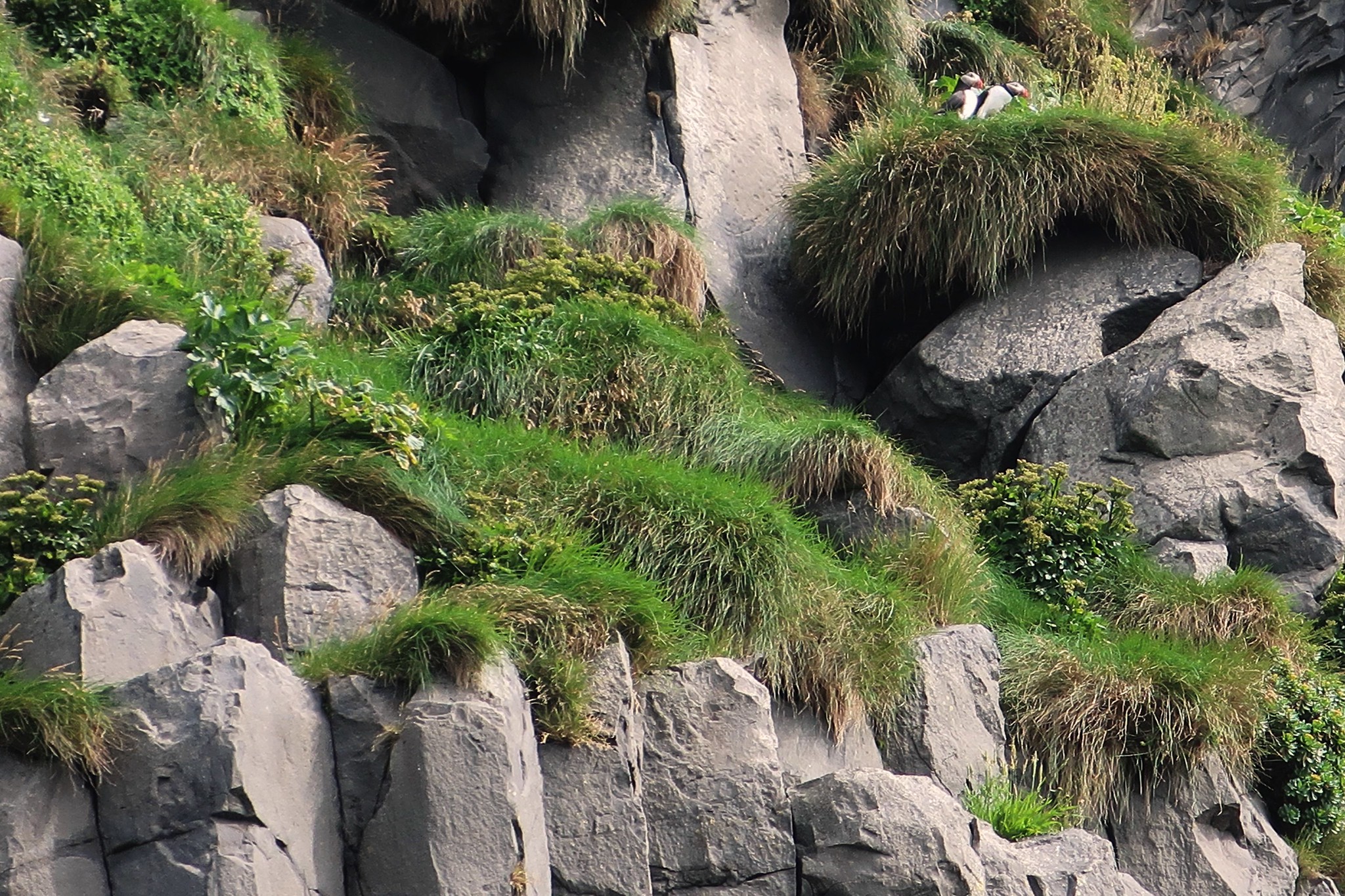
Puffins nest on the cliffs, and fly overhead backwards and forwards between the cliff and the sea with their beaks full of sand-eels for their chicks. I don't have a "proper" camera, so this was the best photo I could get.
 IMG_2006
 by
Half Man Half Titanium, on Flickr
Dolphin skull
 IMG_2010
 by
Half Man Half Titanium, on Flickr
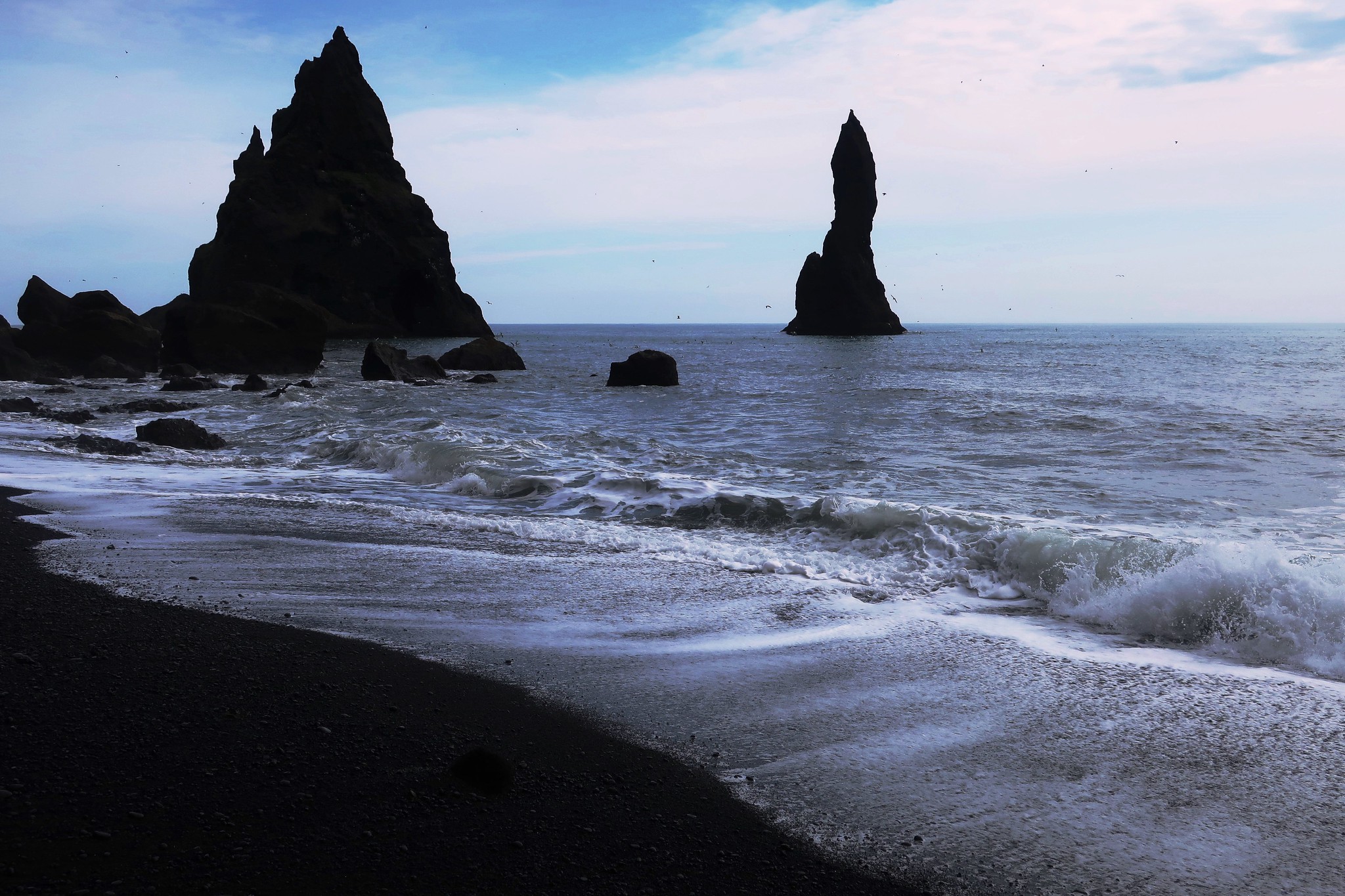
Two of the Reynisdrangar sea stacks dominate the eastern end of the beach
 IMG_2011
 by
Half Man Half Titanium, on Flickr
The view west from the same spot towards the Dyrhólaey peninsula, which is pierced by a remarkable natural tunnel.
 IMG_2012
 by
Half Man Half Titanium, on Flickr
The last of these south coast walks is a long way east along the 1 from Reynisfjara. After crossing the pass over to Vik, the road leads into desolate country. Before reaching the town of Kirkjubæjarklaustur, the weirdest of these areas is a vast plain of lumpy lava flows covered with grey-green moss (Woolly Fringe Moss, according to the information board at the tiny picnic area in the middle of the flows). A fog came down from nowhere when we got here, adding to the atmosphere. A short trail leads to a viewpoint overlooking the wilderness.
 IMG_0047
 by
Half Man Half Titanium, on Flickr
The flows date from the late eighteenth century, and are the result of huge eruptions that caused what Icelanders call the Mists of Hardship - volcanic vapours that affected agriculture so badly that around one-fifth of all Icelanders left the island.
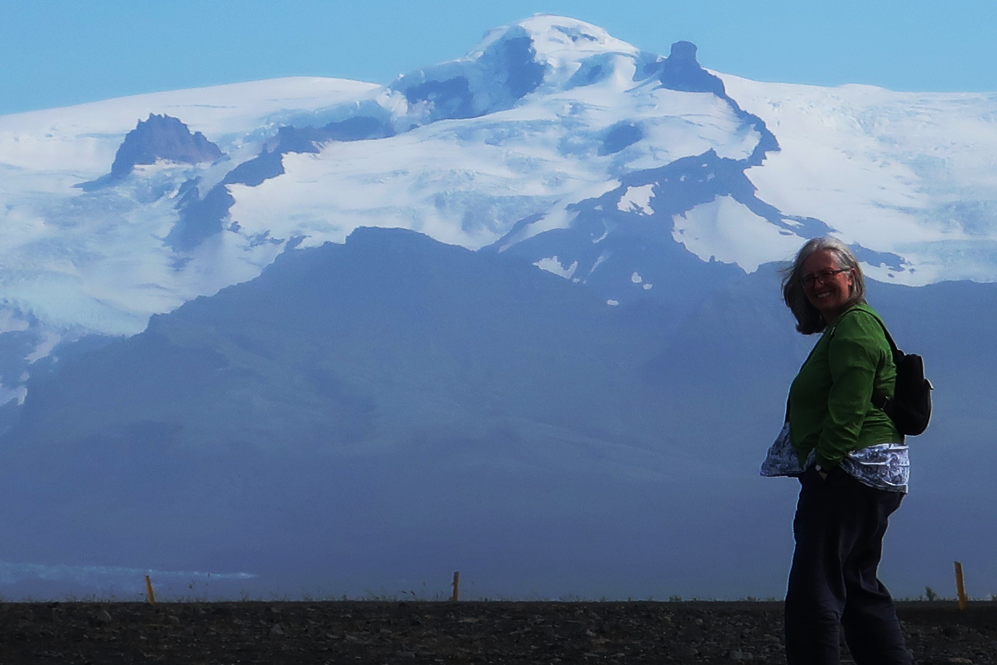
Beyond Kirkjubæjarklaustur, miles of grandiose scenery unfold along the 1, fringing the Vatnajökull icecap which covers much of south-east Iceland. There were fine views where the road crosses a vast outwash of glacial debris below the highest mountain in Iceland, Hvannadalshnjúkur.
 IMG_0036
 by
Half Man Half Titanium, on Flickr
Hvannadalshnjúkur is actually the edge of the crater rim of a gigantic hidden volcano, Öraefajökull. The ice in the crater is over half a kilometre thick. The volcano is active: there were huge eruptions in 1362 and 1728, and rumblings in 2017.
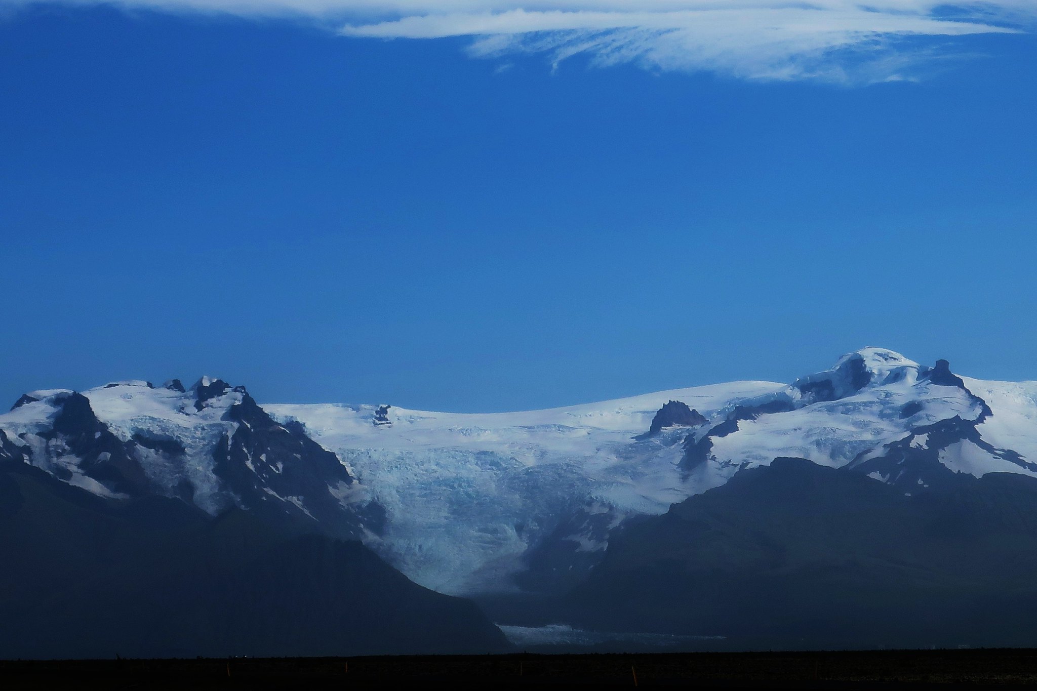
This wider view of the Hvannadalshnjúkur massif shows the icefall of the glacier Svinafellsjökull, which flows down from the crater rim. (The black line at the bottom of the photo is the tarmac of Highway 1)
 IMG_3818
 by
Half Man Half Titanium, on Flickr
A closer view of Hrútfjallstindar, another of the main peaks.
 IMG_3831
 by
Half Man Half Titanium, on Flickr
Hrútfjallstindar and Hvannadalshnjúkur from the national park visitor centre at Skaftafell. There are a variety of trails from here including another waterfall, Svartifoss, which sadly we did not have time to get to.
 IMG_3833
 by
Half Man Half Titanium, on Flickr
Glaciers line the route of Highway 1 from here onwards.
 IMG_4191
 by
Half Man Half Titanium, on Flickr
 IMG_0046
 by
Half Man Half Titanium, on Flickr
Finally, we arrived at our destination, Jökulsárlón lake. This is where a large glacier, Breiðamerkurjökull, flows down from the main Vatnajökull icecap and has gouged this lake, nearly 300m deep, in which icebergs float before breaking up and being carried out to sea along a short river. We saw one berg break in two and collapse into the water, and also watched a seal swimming among the floes. The whole place is an extraordinary sight.
 IMG_0037
 by
Half Man Half Titanium, on Flickr
Vatnajökull icecap and Breiðamerkurjökull glacier in the background.
 IMG_0038
 by
Half Man Half Titanium, on Flickr
You can do a walk along the lake shore, and along the river to the beach, but we decided that first we would do a boat tour among the icebergs - a bizarre experience.
Some of the bergs - they were surprisingly varied in colour and shape.
 IMG_0041
 by
Half Man Half Titanium, on Flickr
 IMG_0042
 by
Half Man Half Titanium, on Flickr
 IMG_0043
 by
Half Man Half Titanium, on Flickr
After that we walked along the river and the basalt beach, watching half-melted bergs being washed ashore.
 IMG_0044
 by
Half Man Half Titanium, on Flickr
 IMG_0045
 by
Half Man Half Titanium, on Flickr
Central and south-west IcelandThere is a wonderful variety of mountain, coastal and countryside walks in this beautiful area, mostly in the county of Árnessýsla. Our few short walks merely scratched the surface of many possibilities.
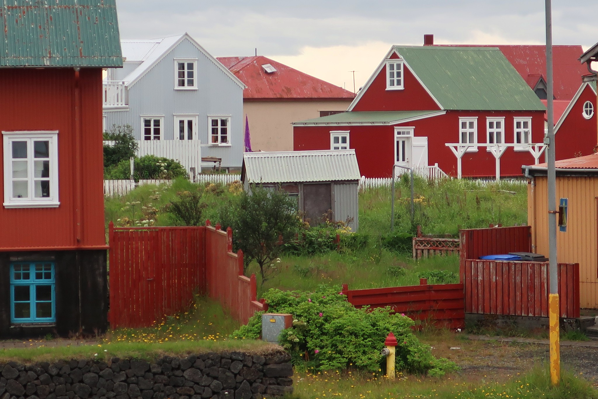
The centre of the area is Selfoss, with a range of shops and accommodation. A few miles south of Selfoss is the coast, centred on a classic Icelandic fishing village, Eyrarbakki.
 IMG_0028 - Copy
 by
Half Man Half Titanium, on Flickr
There is a beautiful walk past the old harbour (once the busiest in Iceland - hard to imagine now) and onto a wide beach west of the village. The white flowers in this photo smelt gorgeous - like an English cottage garden.
 IMG_0029 - Copy
 by
Half Man Half Titanium, on Flickr
This area adjoins the Floi bird reserve, but we didn't need to enter the reserve to see a remarkable sight - a flock of around a hundred whooper swans, all floating placidly on the sea.
 IMG_0030 - Copy
 by
Half Man Half Titanium, on Flickr
We walked back to the village through a meadow filled with flowers.
 IMG_0031 - Copy
 by
Half Man Half Titanium, on Flickr
The village has the Árnessýsla Heritage Museum, a complex of buildings (one ticket covers them all) including this merchant's house dating from 1765.
 IMG_0032 - Copy
 by
Half Man Half Titanium, on Flickr
The atmospheric interior is mostly late nineteenth century.
 IMG_0033 - Copy
 by
Half Man Half Titanium, on Flickr
The Árnessýsla heritage complex includes other houses in the village and a maritime museum - the design of this fishing boat echoed the Viking longships.
 IMG_0034
 by
Half Man Half Titanium, on Flickr
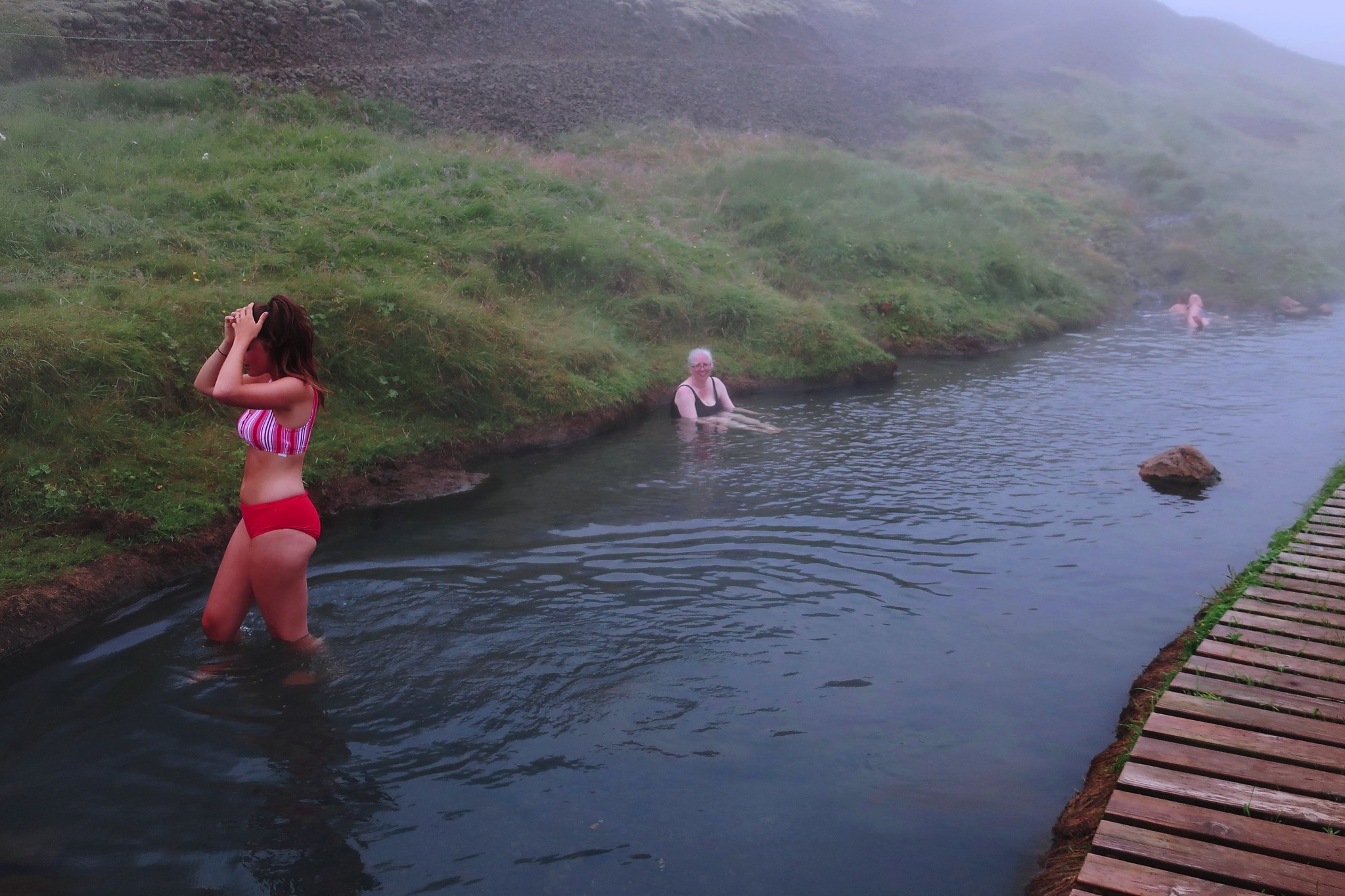
Another of our walks was a few km west of Selfoss, near Hveragerði - a unusual town with lots of greenhouses and florists, based on geothermal energy. Just north of the town a minor road leads to a car park from where a trail leads up the valley of a small river, the Reykjadalur. It was a misty day when we did this walk.
 IMG_2030
 by
Half Man Half Titanium, on Flickr
The river is WARM! - the temperature of a hot bath. Higher up, there is an area set up for enjoying the hot springs. There is a small boardwalk, but it is all done very unobtrusively, with minimum impact on the wild setting.
 IMG_2032
 by
Half Man Half Titanium, on Flickr
My advice for this walk (and bathe) is to go early. It was fairly quiet when we were there, but as we were walking down, there were lots of people walking up, all armed with bathing suits and towels, and the car park was busy.
The geothermal mountain at the centre of this area is called Hengill - its square-cut summit is an obvious feature of the views from the Reykjavik area, and on clear days the numerous steam vents on all its flanks and in the surrounding valleys are quite a sight.
We also visited the northern side of the Hengill massif via the 435 road, which turns off the 1 just south of Reykjavik and offers a surreal drive across pancake-flat moorland, parellel to a huge geothermal pipeline. Then the terrain becomes more rugged...
 IMG_3164
 by
Half Man Half Titanium, on Flickr
Just beyond the highest point there is a car park and information board showing a network of trails on Hengill. There is also a bird's eye view of one of the geothermal power plants.
 IMG_0009 - Copy
 by
Half Man Half Titanium, on Flickr
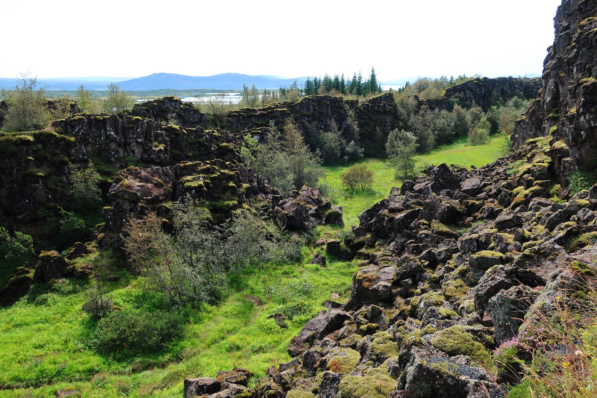
Most visitors to Iceland visit Þingvellir, and I would recommend the 435 as a more scenic and interesting way to approach it than the usual 36 which all the tourist coaches use. The road gives great views of the lake Þingvallavatn. Apparently the ample supply of fish from this lake was one of the reasons the Vikings chose Þingvellir as the site of their parliament, the Alþingi.
The site of the parliament is in a huge cleft in the rocks, at the junction of the North American and European tectonic plates.
 IMG_0012 - Copy
 by
Half Man Half Titanium, on Flickr
Where the gap opens out, there is a small grassy hill where the Alþingi would assemble. The speaker would face away from the crowd, towards the wall of rock, which acted as a sound amplifier.
 IMG_0013 - Copy
 by
Half Man Half Titanium, on Flickr
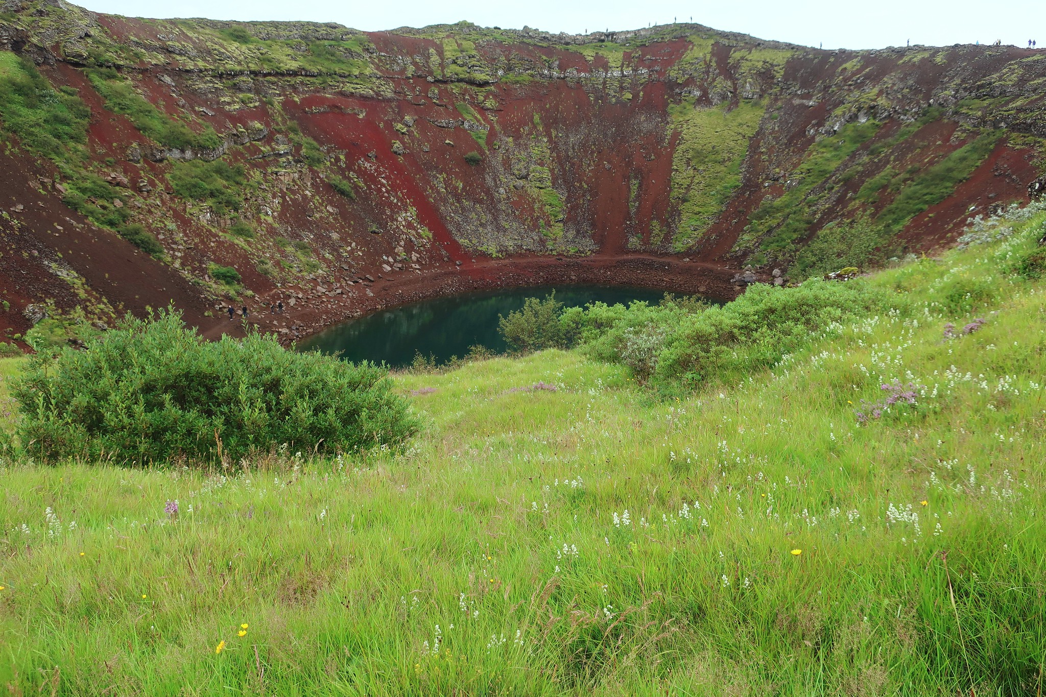
A few miles south of Þingvellir is the vividly-coloured crater Kerið.
 IMG_0024 - Copy
 by
Half Man Half Titanium, on Flickr
It is one of several craters which can be visited: the rims merge together, forming a kind of meandering ridge walk.
 IMG_0025 - Copy
 by
Half Man Half Titanium, on Flickr
Although this was a site of eruptions, the craters were caused not by explosions but by the emptying of a magma chamber deep underground, leading to collapse.
Another view of the main crater. Björk once did a concert from a raft on the lake.
 IMG_0026 - Copy
 by
Half Man Half Titanium, on Flickr
Kerið is on the 35, a good road for visiting the valleys around the Hvítá river. The first place we visited beyond Kerið was the church at Skalholt.
 IMG_2037
 by
Half Man Half Titanium, on Flickr
The church is on the site of Iceland's former cathedral which was destroyed by an earthquake. It's a beautiful spot among meadows above the Hvítá river. We had a picnic and watched this redwing which had caught a worm and a moth.
 IMG_2038
 by
Half Man Half Titanium, on Flickr
We saw a cello player walking through the meadows towards the church.
 IMG_2039
 by
Half Man Half Titanium, on Flickr
She was one of the musicians playing in the Skalholt summer concerts programme -
http://en.sumartonleikar.is/ which we went to hear. It was wonderful.
 IMG_2041
 by
Half Man Half Titanium, on Flickr
A few miles beyond Skalholt is another area of hot springs centred on the market garden village of Reykholt. There are some huge geothermal greenhouses -
 Untitled
 by
Half Man Half Titanium, on Flickr
But my favourite spot was this hidden magical grove.
 IMG_2036
 by
Half Man Half Titanium, on Flickr
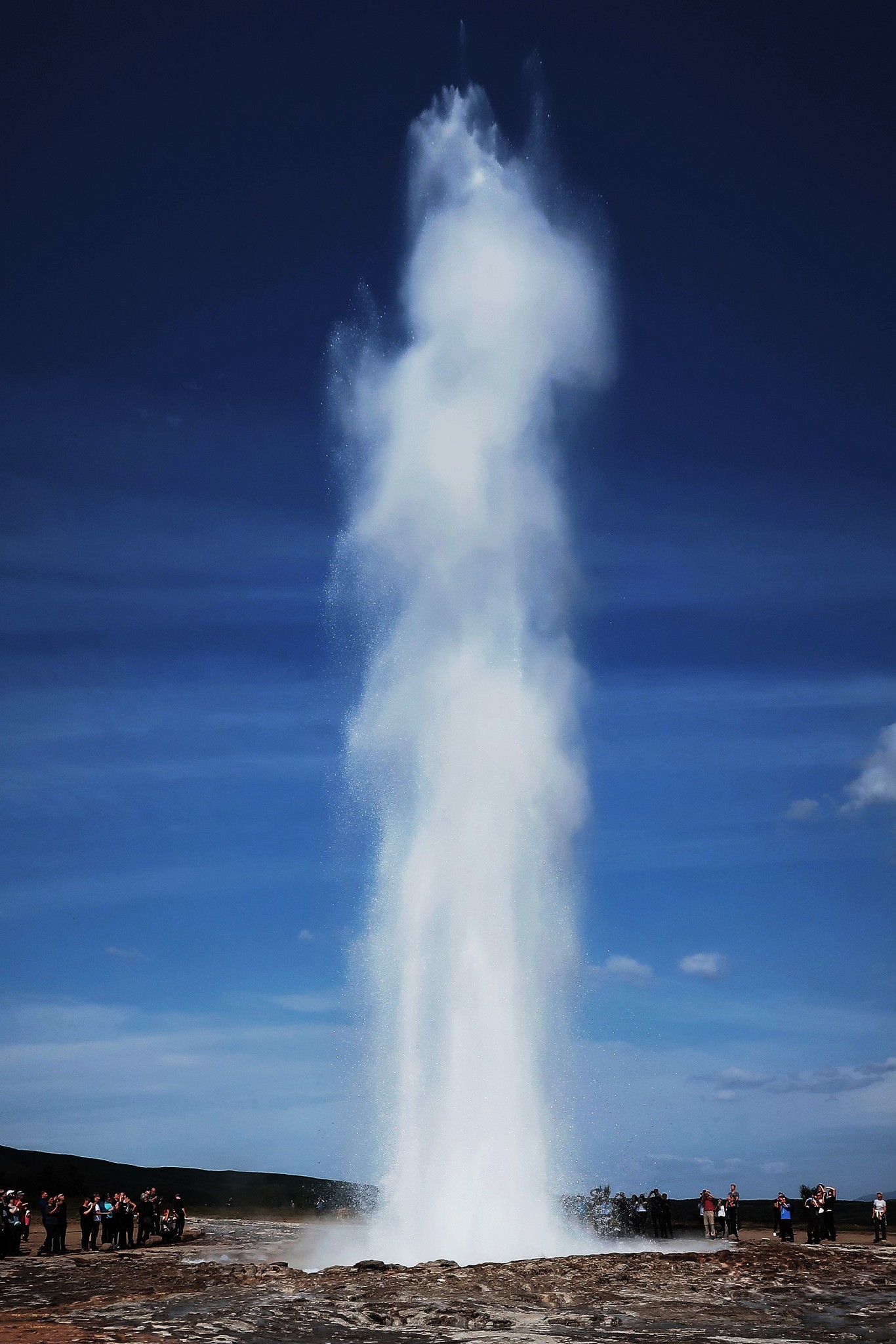
Beyond Reykholt the valley continues to be lush and attractive as far as one of Iceland's most famous attractions, the hot springs at Haukadalur, including Geysir, the origin of the word geyser. There is a walking trail around the area.
Geysir itself is only rarely active today, but it was more than made up for by its companion Strokkur, which spouted every five or six minutes.
 IMG_0017 - Copy
 by
Half Man Half Titanium, on Flickr
One of the boiling thermal pools, coloured by minerals.
 IMG_0018 - Copy
 by
Half Man Half Titanium, on Flickr
The countryside around the geysers was contrastingly pastoral.
 IMG_0019 - Copy
 by
Half Man Half Titanium, on Flickr
Strokkur again
 IMG_0020 - Copy
 by
Half Man Half Titanium, on Flickr
Only a few miles away, another major attraction is the colossal cataract of Gullfoss.
 IMG_0022 - Copy
 by
Half Man Half Titanium, on Flickr
Gullfoss was probably the most popular single attraction we saw - the crowds can be seen in the photo above. However it did not spoil the majesty of this extraordinary place.
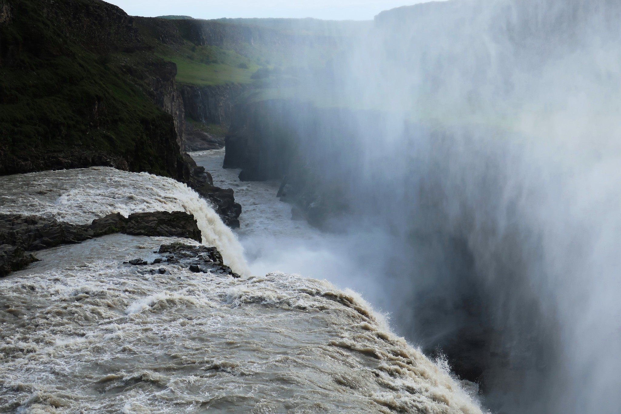 IMG_0023 - Copy
 by
Half Man Half Titanium, on Flickr
Sigríður Tómasdóttir rode regularly from Gullfoss to Reykjavik for many years to fight a court case to save Gullfoss from being made into a hydroelectric power station. She was adept at publicity, which led to the government stepping in and buying the area to protect it from development. She is much celebrated in Iceland as a pioneering environmentalist.
Perhaps we need a Sigríður to campaign for Glen Etive and other special places in the Highlands!
Reykjanes peninsulaThis finger of land is a total contrast to the Snaefell peninsula or the area around Selfoss. It's flat and grim-looking, covered with recent lava flows on which little vegetation grows. Weather on this day was also grim - but it didn't stop us enjoying this place, which felt like another planet.
The gap between the European and North American tectonic plates runs through Reykjanes, where a bridge has been built across the raw lava flows - this is the view from it.
 IMG_0001 - Copy
 by
Half Man Half Titanium, on Flickr
The coast was "bracing"
 Untitled
 by
Half Man Half Titanium, on Flickr
The small town of Grindavik is a no-frills working port.
 IMG_0003 - Copy
 by
Half Man Half Titanium, on Flickr
But it does have a very nice dock-side cafe (Bryggjan) - a welcome haven on a wet day.
Grindavik is only a couple of km from the tourist attraction of the Blue Lagoon. We didn't go.
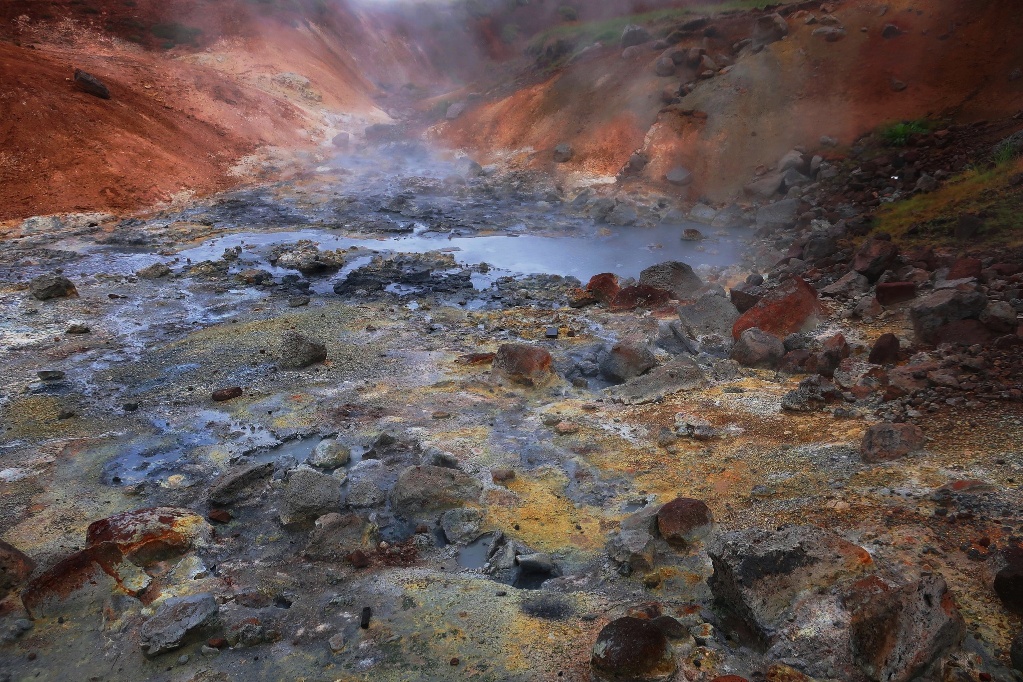
We preferred to walk around the dramatic geothermal area Seltun, at Krýsuvík on the 42 which leads back to Reykjavik.
 IMG_0006 - Copy
 by
Half Man Half Titanium, on Flickr
 IMG_0007 - Copy
 by
Half Man Half Titanium, on Flickr
Hints and tips on visiting IcelandThe best way to see Iceland is to hire a car. There are guided tours and coach trips to all the major sights and attractions, and 4x4 trips further afield - they are all no doubt very good. But if, like us, you like serendipity and enjoying places at your own pace, a car is the best way.
With an ordinary car, you can visit enough places to easily fill a week or two's holiday - we were there for one week and used a VW Polo. But if you really want to get off the beaten track, you will need to hire a 4x4. Be aware that even some main roads have gravel sections (on our map, these sections were marked in brown instead of red).
When driving, it's worth bearing in mind that other drivers may well be tourists who have hired vehicles that they are not used to driving. Away from Highway 1, most roads are really quiet, but don't stop in the road just to take photos - there are car parking spots every few miles.
The car parks for Gullfoss, Geysir and the river walk at Hveragerði can be busy later in the day. Some car parks are small, which is fair enough - it would be a shame if they encroached more on the wilderness. Most places are fairly quiet before noon.
We did not climb any mountains, although there is a fair bit of ascent on the walk to the bathing area at Hveragerði - comparable to a moderate fell walk in the Lake District. If you are visiting Iceland mainly to see the sights, but you do want to climb one mountain, then the most obvious option would be Esja, north of Reykjavik. It is nearly Munro height (914m) and apparently has a clear walking trail to the summit. Given its location above the bays and fjords of the west coast, the views should be stunning. The other easy option of a peak would be Hengill - use one of the trails from the car park on the 435 (see above).
Icelandic weather forecasts in English are at
https://en.vedur.is/. Our experience was that weather patterns in Iceland are every bit as complex and variable as in Scotland. On more than one occasion we drove from sunshine into storms, and back again into sunshine within an hour or so.
Free general maps can be found at
https://www.moon.com/maps/europe/iceland/. For more detailed maps (1:200,000 and 1:50,000), see
http://www.stanfords.co.uk/Iceland-M%C3%A1l-og-Menning-Touring-and-Hiking-Maps_SI00000600It's a blatant truism that Iceland is expensive, but you can hugely reduce your costs by not drinking/eating out, and buying your food from supermarkets. The commonest ones are Krónan (yellow logo) and Bonus (pink piggy-bank logo). Selfoss, Hvolsvöllur and Borgarnes are good places to stock up before heading into the countryside.
Although we stayed near Reykjavik (for easy access to Highway 1) we were unusual in that we chose not to visit the capital. It seemed better to spend our limited time on the kind of places that make Iceland unique, and we have no regrets about not using one of our days to see urban sights.
