
Llangollen History Trail
Hello people and pooches. It’s Joe the Cocker here again. Me and my human dad have just been on a hike in North Wales. My dad said to me, out of the blue, ‘shall we go for an afternoon to the hills’? Well, you know me, I jumped at the chance. Storm Ciara had, more or less, left us in its wake and Storm Dennis was a couple of days away so, we took advantage of the break in the weather. It was quite mild for February but, the wind was blowing a bit cold. Llangollen is only approximately 45 minutes drive away so, off we went.
 20200212_195559 by Mal Davies, on Flickr
The Llangollen History Trail is only 6 miles long but, with a bit of meandering we planned to cover around 8 miles. There are a couple of hills to climb so, we expected it to take us about 3 to 4 hours including photo stops and a short rest break. We were expecting our fair share of mud to yomp through because of the events of the last few days. The River Dee, that runs through the centre of Llangollen, had been a lot higher than usual and streams had been bursting their banks. There is a leaflet available on-line or from the Tourist Information Centre that describes the circular trail so rather than give a description, turn by turn, of the route I will describe what we saw on the way.
 20200212_195238 by Mal Davies, on Flickr
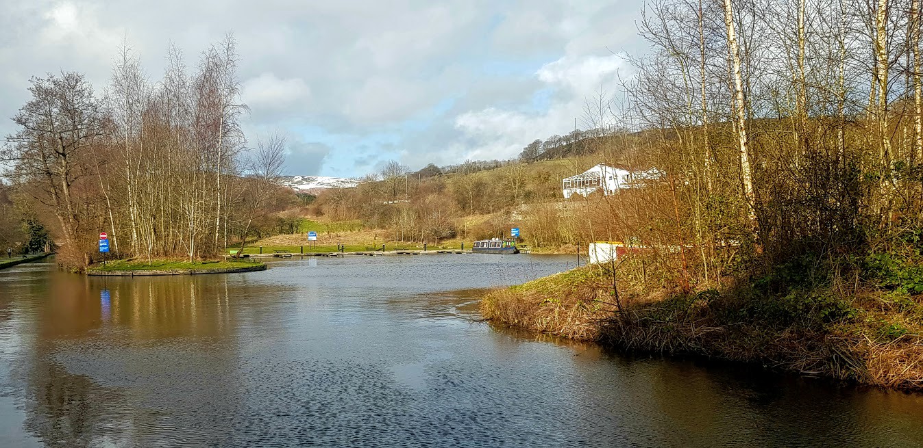
After parking in the town’s Long Stay carpark we had a quick stop by the road bridge that spans the white water of the River Dee. The narrow stone arched structure dates back to 1345 and has been widened twice since. We passed the railway station, with its steam train, before we walked uphill to the Llangollen Canal. The walk along the compacted gravel towpath was pleasant and allowed us to admire the scenery. Well, my dad admired the scenery while I concentrated on the chirping birds in the hedgerows. I even had the odd slurp of water from the canal while I leant over, almost too far at times, reaching for the ducks that were taunting me. The canal was built in 1805 to enable the transportation of slate from nearby quarries. It is now used primarily by pleasure boats and has been since 1884! The Berwyn hills had a light dusting of snow deposited in the last few chilly nights. The Vale of Llangollen had taken a battering from the high winds, as had the whole country and there were plenty of tree branches littering the path. Stick heaven! I loved it as I was spoilt for choice with which stick to pick up and chew.
 20200212_195517 by Mal Davies, on Flickr
 20200212_195334 by Mal Davies, on Flickr
We passed the Motor Museum and the Royal International Pavilion as we strolled in the sunshine. The pavilion houses the world-renowned International Eisteddfod annually. At one point the river, the canal, the road and the railway line all ran side by side. We passed along the back of the Chainbridge Hotel before we reached the end of the canal at the Horseshoe Falls. The ‘falls’ is actually a weir, designed by Telford in 1806 to supply water from the River Dee to the adjacent Llangollen Canal. It was time for another drink for me, this time from the fast-flowing river. My dad kept me on my lead because I wanted to have a dip in the river. He said that it was too dangerous so I could only have a paddle on the sandy bank.
 20200212_194731 by Mal Davies, on Flickr
 20200212_194805 by Mal Davies, on Flickr
 20200212_133402 by Mal Davies, on Flickr
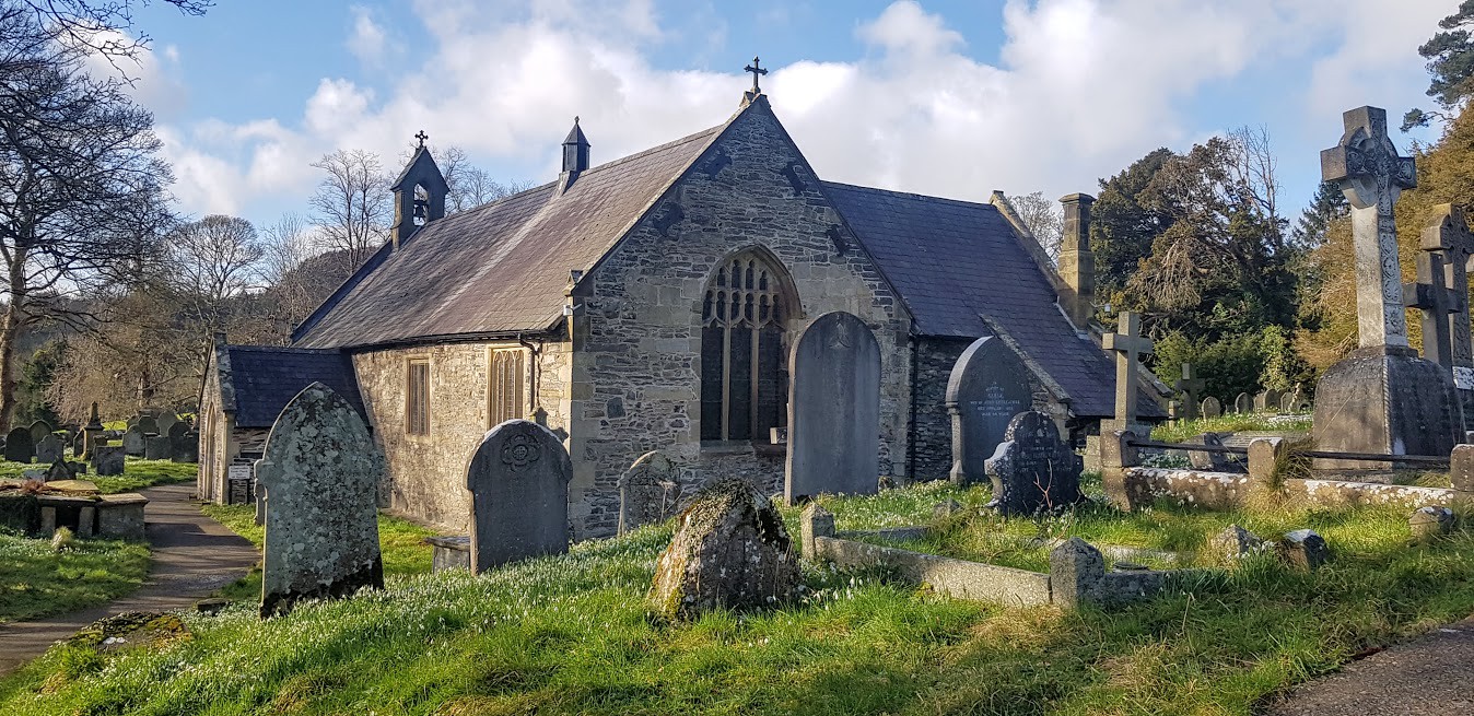
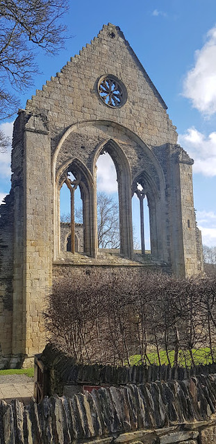
Just above the falls we came to Llantysilio Church which was originally built in 1254. It was restored in 1869 and contains medieval windows and a rare oak lectern. I wasn’t allowed inside and so my dad took a photograph and we carried on towards Velvet Hill. The hill is named after the smooth sheep-cropped grasses and mosses that cover its surface. We had views from this point towards Castell Bran, which was one of our targets for the day. As we started to descend the hill Valle Crucis Abbey appeared in the valley below us. The Cistercian abbey was founded in 1201 and the ruins still stand proudly in the valley.
 20200212_194432 by Mal Davies, on Flickr
 20200212_192521 by Mal Davies, on Flickr
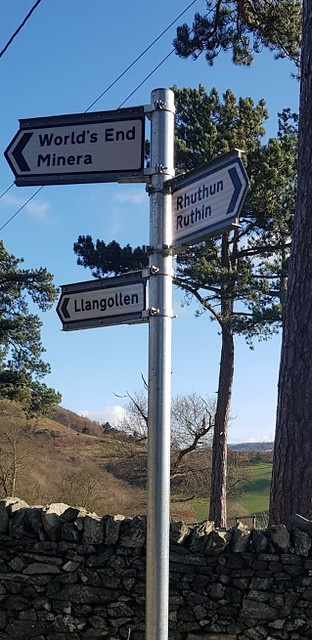
My dad spotted a road sign pointing towards Worlds End. That was his cue to burst into song. ‘It’s the End of the World as We Know it’ by REM. It was a bit obvious, I suppose. With hindsight I should have distracted him. So annoying!
 20200212_192826 by Mal Davies, on Flickr
We passed through a caravan site, over a footbridge and up a steep flight of steps to the top of a hill before walking along large field. After a stroll along a gentle incline, that overlooked the valley, we came to a viewpoint with a few benches built onto a rock. We had a short break here while my dad lost his glasses. Clumsy boy! We had a few stiles to negotiate along the path, some with ‘dog hatches’ and others that I had to be lifted over. We walked along a mixture of path, track, minor road and across fields until we reached the Panorama Walk. The walk took us along the foot of the limestone cliffs on a minor road to the foot of Castell Bran.
 20200212_142542 by Mal Davies, on Flickr
 20200212_134137 by Mal Davies, on Flickr
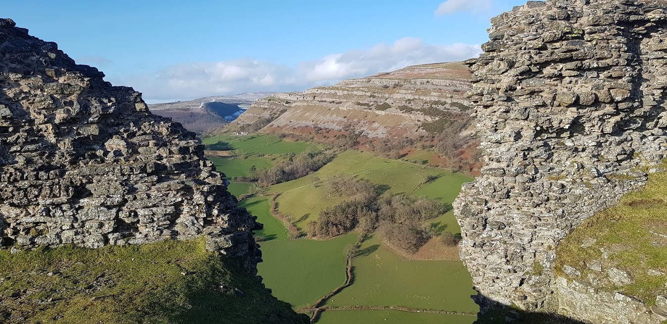
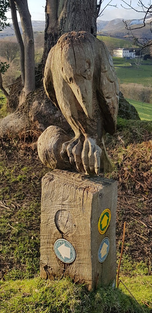
When we reached the foot of the hill that Castell Bran sits atop we had a short break because the hillside that we were about to climb was grass covered and looked very slippery. We were right but, I found it easy to run up while my dad slipped a few times as he was walking. The castle was built by Prince Gruffudd ap Madoc in 1260 and deserted not long after in 1277. Dinas Bran translates as Crow Castle and carvings and sculptures of the bird can be found in the area. The castle has Arthurian legend status and is reputed to be the hiding place of the Holy Grail. Legend also says that a silver harp is buried on the hill. Perhaps my dad would let me start digging for these treasures instead of pulling me away from the grazing sheep.
 20200212_151930 by Mal Davies, on Flickr
 20200212_194032 by Mal Davies, on Flickr
 20200212_192956 by Mal Davies, on Flickr
 20200212_193403 by Mal Davies, on Flickr
 20200212_193606 by Mal Davies, on Flickr
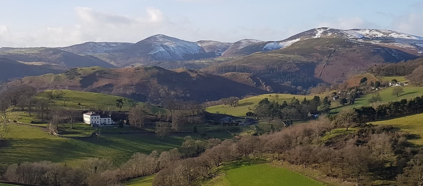
My dad loved the views from the top of the hill especially into the distance where the aquaduct at Pontcysyllte spans the dee valley. Below us, as we descended towards Llangollen, the view would have been amazing if not for the dazzling sun as it was low in the western sky. The path is stony and steep in places but easy to follow. It was only about 20 minutes back to Llangollen where the car was parked. We had a short walk along the path at the side of the Dee where my dad took another photograph of the bridge from water level.
 20200212_193753 by Mal Davies, on Flickr
We were back at the car just as the sun dropped behind the Berwyns and were both covered in mud, yet again. It had been a good varied walk with plenty of distractions for my dad. Oh yes, and plenty of sticks to chew and mud to wallow in for me. Till the next time!
20200212_195559 by Mal Davies, on FlickrThe Llangollen History Trail is only 6 miles long but, with a bit of meandering we planned to cover around 8 miles. There are a couple of hills to climb so, we expected it to take us about 3 to 4 hours including photo stops and a short rest break. We were expecting our fair share of mud to yomp through because of the events of the last few days. The River Dee, that runs through the centre of Llangollen, had been a lot higher than usual and streams had been bursting their banks. There is a leaflet available on-line or from the Tourist Information Centre that describes the circular trail so rather than give a description, turn by turn, of the route I will describe what we saw on the way.
20200212_195238 by Mal Davies, on FlickrAfter parking in the town’s Long Stay carpark we had a quick stop by the road bridge that spans the white water of the River Dee. The narrow stone arched structure dates back to 1345 and has been widened twice since. We passed the railway station, with its steam train, before we walked uphill to the Llangollen Canal. The walk along the compacted gravel towpath was pleasant and allowed us to admire the scenery. Well, my dad admired the scenery while I concentrated on the chirping birds in the hedgerows. I even had the odd slurp of water from the canal while I leant over, almost too far at times, reaching for the ducks that were taunting me. The canal was built in 1805 to enable the transportation of slate from nearby quarries. It is now used primarily by pleasure boats and has been since 1884! The Berwyn hills had a light dusting of snow deposited in the last few chilly nights. The Vale of Llangollen had taken a battering from the high winds, as had the whole country and there were plenty of tree branches littering the path. Stick heaven! I loved it as I was spoilt for choice with which stick to pick up and chew.
20200212_195517 by Mal Davies, on Flickr20200212_195334 by Mal Davies, on FlickrWe passed the Motor Museum and the Royal International Pavilion as we strolled in the sunshine. The pavilion houses the world-renowned International Eisteddfod annually. At one point the river, the canal, the road and the railway line all ran side by side. We passed along the back of the Chainbridge Hotel before we reached the end of the canal at the Horseshoe Falls. The ‘falls’ is actually a weir, designed by Telford in 1806 to supply water from the River Dee to the adjacent Llangollen Canal. It was time for another drink for me, this time from the fast-flowing river. My dad kept me on my lead because I wanted to have a dip in the river. He said that it was too dangerous so I could only have a paddle on the sandy bank.
20200212_194731 by Mal Davies, on Flickr20200212_194805 by Mal Davies, on Flickr20200212_133402 by Mal Davies, on FlickrJust above the falls we came to Llantysilio Church which was originally built in 1254. It was restored in 1869 and contains medieval windows and a rare oak lectern. I wasn’t allowed inside and so my dad took a photograph and we carried on towards Velvet Hill. The hill is named after the smooth sheep-cropped grasses and mosses that cover its surface. We had views from this point towards Castell Bran, which was one of our targets for the day. As we started to descend the hill Valle Crucis Abbey appeared in the valley below us. The Cistercian abbey was founded in 1201 and the ruins still stand proudly in the valley.
20200212_194432 by Mal Davies, on Flickr20200212_192521 by Mal Davies, on FlickrMy dad spotted a road sign pointing towards Worlds End. That was his cue to burst into song. ‘It’s the End of the World as We Know it’ by REM. It was a bit obvious, I suppose. With hindsight I should have distracted him. So annoying!
20200212_192826 by Mal Davies, on FlickrWe passed through a caravan site, over a footbridge and up a steep flight of steps to the top of a hill before walking along large field. After a stroll along a gentle incline, that overlooked the valley, we came to a viewpoint with a few benches built onto a rock. We had a short break here while my dad lost his glasses. Clumsy boy! We had a few stiles to negotiate along the path, some with ‘dog hatches’ and others that I had to be lifted over. We walked along a mixture of path, track, minor road and across fields until we reached the Panorama Walk. The walk took us along the foot of the limestone cliffs on a minor road to the foot of Castell Bran.
20200212_142542 by Mal Davies, on Flickr20200212_134137 by Mal Davies, on FlickrWhen we reached the foot of the hill that Castell Bran sits atop we had a short break because the hillside that we were about to climb was grass covered and looked very slippery. We were right but, I found it easy to run up while my dad slipped a few times as he was walking. The castle was built by Prince Gruffudd ap Madoc in 1260 and deserted not long after in 1277. Dinas Bran translates as Crow Castle and carvings and sculptures of the bird can be found in the area. The castle has Arthurian legend status and is reputed to be the hiding place of the Holy Grail. Legend also says that a silver harp is buried on the hill. Perhaps my dad would let me start digging for these treasures instead of pulling me away from the grazing sheep.
20200212_151930 by Mal Davies, on Flickr20200212_194032 by Mal Davies, on Flickr20200212_192956 by Mal Davies, on Flickr20200212_193403 by Mal Davies, on Flickr20200212_193606 by Mal Davies, on FlickrMy dad loved the views from the top of the hill especially into the distance where the aquaduct at Pontcysyllte spans the dee valley. Below us, as we descended towards Llangollen, the view would have been amazing if not for the dazzling sun as it was low in the western sky. The path is stony and steep in places but easy to follow. It was only about 20 minutes back to Llangollen where the car was parked. We had a short walk along the path at the side of the Dee where my dad took another photograph of the bridge from water level.
20200212_193753 by Mal Davies, on FlickrWe were back at the car just as the sun dropped behind the Berwyns and were both covered in mud, yet again. It had been a good varied walk with plenty of distractions for my dad. Oh yes, and plenty of sticks to chew and mud to wallow in for me. Till the next time!