free to be able to rate and comment on reports (as well as access 1:25000 mapping).
I did most of the Rob Roy Way in April 2015, but bowed out on the sixth day as the distance was a bit more than I could handle at the time. (See that walk report
here.) This year I came back to finish it, and I was lucky enough to have brilliant sunshine on 6 of the 7 days of the walk!
Friday 10 May 2019
Drymen to Aberfoyle: "Piu mosso"
Distance: 11 miles
Start: 8:50am
Finish: 1:45pm
Weather: Partly cloudy in the morning, drizzly in the afternoon
I caught a commuter train from Glasgow to Alexandria this morning, and then a bus from Alexandria to Drymen. As far as I know there is no monolith or anything to mark the beginning/end of the Rob Roy Way in Drymen - just a National Cycle Route signpost with a RRW blaze on it. I got someone to take my "starting line" photo and cracked on.
There was bumper-to-bumper foot traffic on the road north out of Drymen. Most of the other walkers were making their way back to the West Highland Way, and after the intersection of the two paths I had the trail almost to myself except for a couple who I leapfrogged with for most of the morning.
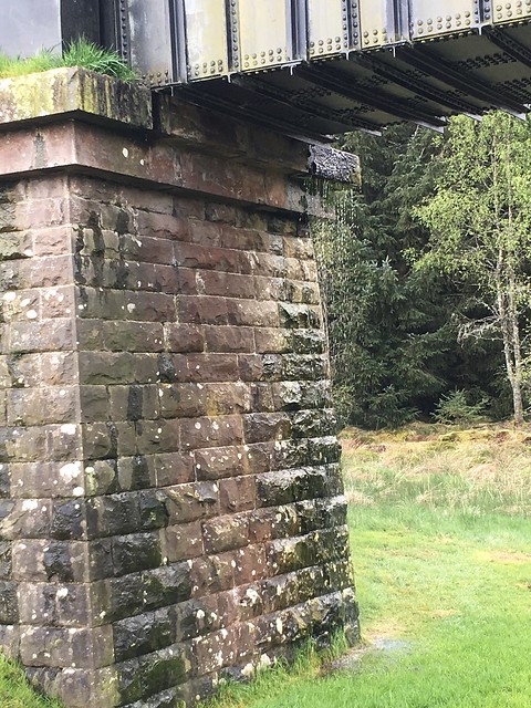
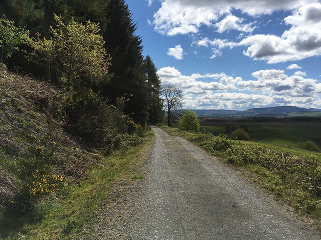
I recalled this being a fairly nondescript day, and my recollection was correct. The path is entirely on minor roads and forestry roads today, which are uncomfortable underfoot, and the views are okay but not stunning. Still, I lounged by Corrie Aqueduct (which appeared to be leaking?) at lunchtime until a cloud went in front of the sun and I realized I'd better press on if I didn't want to get rained on!
Lounging:

Leaky aqueduct?
I did get rained on, just a little bit. But I still got to Kirkton early enough to have a wander around the cemetery, killing some time until I could check in at the Forth Inn in Aberfoyle. I found this day much easier than I did four years ago.

The only black mark on the day was taking off my trousers in my room at my accommodation and discovering I had picked up a tick - my first ever! I was proud of myself though - I tweezed it off on about the sixth or seventh try and only freaked out a little bit.

Song of the day: "Waly Waly" - Scottish traditional
***
Saturday 11 May 2019
Aberfoyle to Callander: "I guess this is the right way?"
Distance: 9.5 miles
Start: 10:20am
Finish: 3:45pm
Weather: Sunny
I got a purposely late start this morning, because I'd told my host in Callander that I wouldn't be there until sometime after 5pm. The Forth Inn doesn't start serving breakfast until 9am anyway, which I think is peculiarly late!
Last night's dinner of chips with curry sauce was talking back in a big way, so I popped into the pharmacy for some ranitidine and then tried to find my way out of town. This stage of the Rob Roy Way suffers from an egregious lack of waymarking, and the waymarkers that do exist are vague. The arrow that I assume is supposed to point up the hill to Dounans Camp appears to point into someone's back garden instead. But after a little bit of head-scratching and map-consulting, I found where I was supposed to go and I was on my way.
It was a gorgeous day today. Sunny and almost the perfect temperature. It took my five and a half hours to travel nine and a half miles today, not because of any difficulty with the terrain, but because I kept stopping to admire the view!
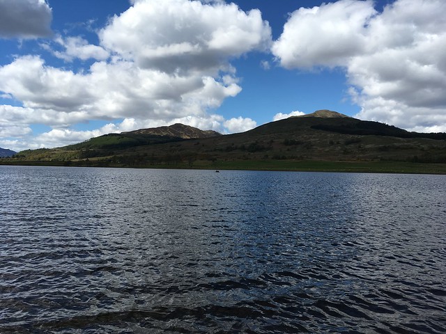
I climbed up the shoulder of the Menteith Hills and crossed a sheep pasture, stopping by a burn at the far end to take in the scenery. I was dislodged from my spot by a large group of kids with their chaperones, presumably out for the day, and continued past a lochan jumping with fish. Then I wended and descended my way along Loch Venachar, marveling at the views across to Ben Ledi and (I think?) the Loch Earn Munros beyond. When I got to the lochside I stopped for a good long while at one of the picnic areas. I was on pace to get to Callander early despite my late departure from Aberfoyle, so I decided I'd rather kill time looking at the pretty loch than loitering around Callander.
Eventually I bestirred myself, gave my boots a quick wash in the loch, and pushed on. There were lots of people out enjoying the fine day, playing by the loch, barbecuing, etc. Someone's dog growled at me as I passed, which was disconcerting. I walked into Callander at 3:45 and happened to meet my Airbnb host on the street. He waved me inside early - what a gent.
Goodnight Ben Ledi:

Song of the day: "Sultans of Swing" by Dire Straits
***
Sunday 12 May 2019
Callander to Strathyre: "Happiness is..."
Distance: 9 miles
Start: 9:30am
Finish: 2:15pm
Weather: Sunny
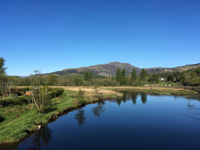
The day dawned almost cloudless. I found a place on Callander's high street that was open for breakfast, and finished my meal just as a tour bus disgorged its passengers onto the premises. I got a photo of Ben Ledi from the bridge over the River Teith, and then began the day's walk.
Good morning Ben Ledi:
This was my favorite day when I did the Rob Roy Way four years ago, and I think it's going to remain my favorite day. I enjoyed it even more than last time, because today it was sunny instead of sleeting! I followed the riverside track out of Callander and toward Ben Ledi, and for a mad moment as I approached the foot of the hill I considered going up it. I came to my senses and decided against it (not with a full pack on!), but clearly lots of other people had decided that this was a day to be up a hill - the car park was absolutely slammed full.
I stopped briefly at the forest cafe for a scone and an elderflower soda, and then continued on. As I drew alongside Loch Lubnaig, I thought how nice it would be to find a nice spot by the lochside and just relax for a while. Just then, I spotted a little side trail going down to the shore. Don't mind if I do! I took my boots off for a toe-dip in the loch (cold!), and then just basked like a lizard in the sun for nearly an hour. It was barely noon, I was already more than halfway to Strathyre, and it was just too nice a day to be in a hurry.

After a while the wind picked up and it got slightly chilly by the lochside, so I took that as a sign to move on. The path climbed higher, affording even better views, and I just ambled along with the biggest smile on my face. I was still smiling when I reached Strathyre, despite the fact that I'd seen no fewer than four signs proclaiming "Strathyre - 1 mile" over the preceding two miles or so.
Song of the day: 4th movement from
The Ninth Symphony by Ludwig van Beethoven
***
Monday 13 May 2019
Strathyre to Killin: "Butterflies"
Distance: 13 miles
Start: 9:20am
Finish: 3:00pm
Weather: Sunny and warm
I got a later start this morning than I intended. First my bed was soooo comfortable that I didn't want to get up, so I was late going down to breakfast. Then the breakfast craic with the hosts and other guests was good, so I lingered for a while.
I had an oops moment leaving Strathyre. I set off on the track running along the west side of the road, wondering where on Earth the right-hand turn up into the trees was. I finally pulled the map out and discovered that I'd missed it, but that the trail would eventually be rejoining the track I was on, so no serious harm done in the end.
The path rambled on to Lochearnhead, zigzagging up to meet the disused railway line through Glen Ogle. It was another warm, sunny day, and the views were cracking.

I found a nice flat boulder a little short of the viaduct to sit on and eat my lunch - getting a tick the other day has made me gun-shy about sitting in tall grass. Then I continued on over the viaduct, past the lochan, to the Glen Ogle Burger Van. The van was open for business today, but as I'd only just eaten lunch, I settled for an extra bottle of water and a Snickers. Then I just had the final four miles through Acharn Forest before reaching Killin. The forest seemed to go on for a very long time, but I put my MP3 player on and just concentrated on blasting out the miles until I got to the Falls of Dochart.

I saw plenty of cyclists today but nary another walker.
Enjoying the light show at dusk:


Song of the day: 3rd movement from
Spring by Antonio Vivaldi
***
Tuesday 14 May 2019
Killin to Ardtalnaig: "We might as well be on Mars!"
Distance: 12 miles
Start: 9:55am
Finish: 4:25pm
Weather: Sunny and hot
The climb out of Killin was as I remembered it: long and sweaty. The sun beat down relentlessly all day. Forestry land is not my favorite landscape to walk through, but getting up into the cool shade of the pine plantation was a relief. For the first time on this walk, I had plenty of company: a French couple, an Australian couple, and the couple I'd met on the first day. The Australian couple were planning to do the Amulree loop so I didn't see them again after this day, but the other two couples were to be my shadows over the next two days.

Through the gate and across undulating moorland to the hydro dam. I stopped at the hydro dam to drink water and squint at my map, because I thought I might like to try and bag Creag Gharbh. Onward to the hairpin turn in the path in the path that would bring me closest to the summit, and I saw my mistake: the slope was far too steep to ascend from this direction. I would have done better to start from the hydro dam - the line up the hill from there was now clear. But I didn't really fancy doubling back, so Creag Gharbh will remain unbagged. Oh well.
A gentle descent down to the pipeline, then across the bog to Ardeonaig.

The fine weather of the last four days has gone a long way toward drying up the bog, so it was much easier going than the last time I came this way. Then, relentless tarmac-pounding to Ardtalnaig. I was a tired, sunburned, and thirsty walker toiling up the South Loch Tay road. Passing drivers seemed to be sympathetic - they all seemed to wait for me to give the little "I'm okay" wave before continuing on their way. Finally to Holly Cottage and the camping pod that will be my home for tonight - quite lovely after I chased out a few wasps that had come in through the open window.
Song of the day: "New Wild West" by Jewel
***
Wednesday 15 May 2019
Ardtalnaig to Aberfeldy: "Pine forests are nature's air conditioners."
Distance: 15 miles
Start: 8:30am
Finish: 5:00pm
Weather: Sunny and warm
My arms got quite sunburned yesterday, so I tried to get an early start this morning so I could walk in long sleeves for as long as possible. The day began with four or five miles of tarmac-pounding to Acharn. Then a right-hand turn to leave the road and climb up to the Falls of Acharn. This was where I stopped last time, so I was quite pleased to be pushing on, the view of the falls was the reward. I recommend taking the little detour down to the viewing platform - it's only two minutes' walk and the view is worth it.

The couples I'd been walking with yesterday caught up with me at the Falls of Acharn, which was handy, because the French couple and I were mystified about which fork to take for the Queen's Drive. Luckily the other couple knew, having done it before (it's the right fork). The next few miles were on a pleasant, grassy path that contoured around the hillside and gave great views of Kenmore down below.

Then the path went through forestry land for a bit. I was actually relieved to see the pine trees, because I've discovered on this walk that pine forests are natural air conditioners: the trees actually seem to exhale cold air. I experienced a new walking surface: steamrolled rocks. It looked like the path was maybe waiting to be paved with tarmac - goodness, I hope not.
For a while I'd been following signposts saying "Path to Aberfeldy X miles." They, combined with the views of Aberfeldy drawing ever closer, got my hopes up that the end of the day was near. These hopes were summarily dashed when I saw one of these signposts pointing one way and a Rob Roy Way marker pointing another. The end of this day is frustrating and borderline heartbreaking. The path had been descending toward Aberfeldy for a while, but when I got to the point with the two signposts, the Rob Roy Way turned AWAY from Aberfeldy and began ascending again. Basically, the Rob Roy Way takes a circuitous route into town in order to go through the Birks of Aberfeldy. Then it takes a circuitous route through the Birks. The Birks of Aberfeldy are admittedly very pretty, and the Falls of Moness might actualyl be even more impressive than the Falls of Acharn. But I spent the whole walk through the Birks thinking "This is nice. I wish I were less tired, less hungry, less hot, and less in pain, so I could actually enjoy and appreciate it."

I finally popped out into the Aberfeldy town center and walked up and down the street my accommodation was on, trying to to find it. Two local women finally took pity on me and pointed it out. I was in near-hysterics from a 15-mile day in blazing sunshine when I came through the door, but the landlady was very kind.
Song of the day: "Future Man" by Strength in Numbers
***
Thursday 16 May 2019
Aberfeldy to Pitlochry: "Bluebell fields and border collies"
Distance: 9 miles
Start: 8:20am
Finish: 1:40pm
Weather: Sunny
Last day, let's go! I began following the road east out of Aberfeldy, and stopped about ten minutes into the day's walk to get a haggis roll for breakfast. Suitably fueled, I continued onward, bearing left onto a footpath following the River Tay.

Bluebells!
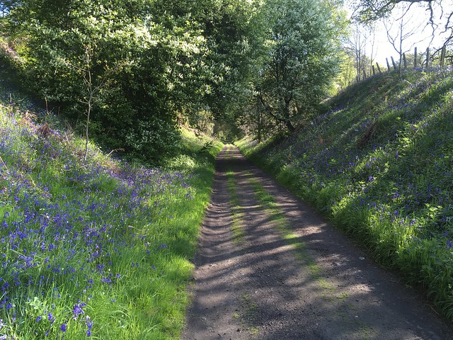
I followed the Tay all the way to Grandtully, and it was my favorite part of the day. The morning was cool, the path was level and comfortable underfoot, and the River Tay was picturesque. The only thing that momentarily disturbed my groove was a border collie, which came tearing around the corner and toward my, tail wagging, tongue lolling, and leash trailing. It hugged me and gave me an enthusiastic kiss attack. At length I was able to pry it off me and herd it ahead of me, back in the direction it came from and where its owners presumably were. Its owners were indeed at the far end of a field a little further along, calling for it.
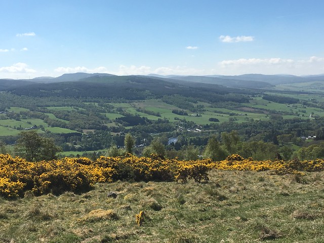
I had intended to stop for a break in Grandtully. However, I arrived there at the same time as a big Rolls-Royce convention, and the only place that was open for food was quickly overwhelmed. Annoyed, and not wanting to wait an hour for the only other eatery in town to open at noon, I walked on. I crossed the Tay and began the long climb out of the valley. It is an unrelenting climb along a golf course and through a sprawling gorse thicket, but the view from the top is amazing.
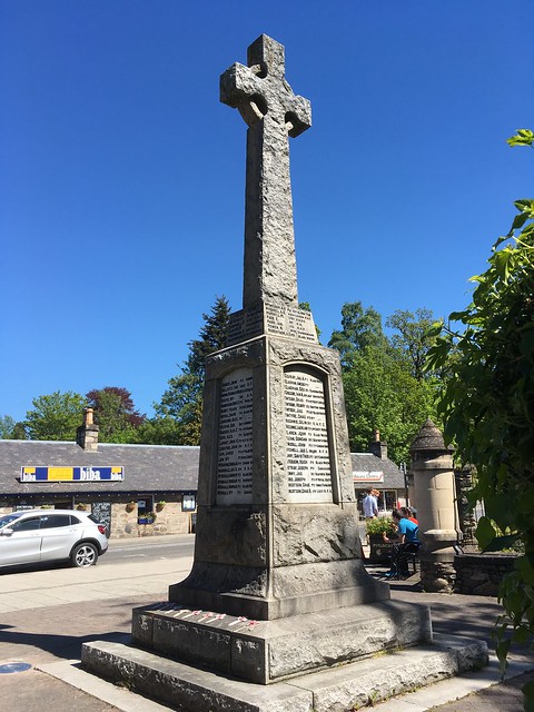
A brief break at the top for water, and then I began the gentler descent down to the River Tummel. Forest track gave way to dirt road, dusty from six days of dry weather. A dash across the A9, over the pedestrian bridge across the Tummel, and I was on the outskirts of Pitlochry. All that was left was a quick walk through the woods to the town center, and the war memorial which marks the end of the Rob Roy Way!
Song of the day: "Heartlines" by Florence + the Machine
I love this trail.

Especially the bit between Aberfoyle and Killin. I'm happy to have completed it, and I suspect I'll be back to revisit parts of it in the future!
