free to be able to rate and comment on reports (as well as access 1:25000 mapping).
First off, many thanks to Guinessman and Bearded Wanderer for their walk reports on the Hebridean Way. They were invaluable resources to supplement the Cicerone guidebook.

I'd eventually like to do the Hebridean Way in its entirety, if and when it gets extended up to the Butt of Lewis. But for this trip, I reckoned that the southern half would be quite enough, especially since I'd never been the Uists and was really keen to go. Some quirks in my wider trip-planning meant that it was more practical to start in Lochmaddy and travel south, so hopefully this walk report will be helpful to people who might want to walk the Hebridean Way southbound.
I arrived in Lochmaddy late on the 2nd of June. I spent the 3rd exploring the town before getting a local bus to Grimsay. North Uist is more water than land, which makes navigation a bit hairy, so I elected to start my walk on Grimsay. Plus there was a nice symmetry to starting and ending my walk through the Hebrides on two smaller islands.

Onward!
*****
Tuesday 4 June 2019
Baymore to Nunton: "Good luck, kid."
Distance: 10ish? miles
Start: 11:15am
Finish: 6:00pm
Weather: Partly cloudy and cool
I had a very pleasant evening on Grimsay last night. Toward dusk I walked from my Airbnb in Baymore to the harbor in Kallin to see what I could see. Grimsay's main industry is fishing, and nowhere was this more apparent than at the harbor - boats and live-storage units everywhere. Turning for home, I managed to get on the southerly loop of the road that circles Grimsay, rather than the northerly one, and didn't realize it for a long while since all my major landmarks - the sun, the water, and Eaval over on North Uist - were correct. I later learned that if I had kept going I would have eventually made it back to Baymore, but as it was I doubled back to the harbor and started over.
Rainbow over Grimsay:

I made it back with plenty of light left and got my hostess to light the peat burner in my room - very cozy. I stayed up for a long time, enjoying the peat-warmed ambience and reading.
I was up at 8:30 this morning and out the door at 9am. The harbor at Kallin is in the opposite direction from the Hebridean Way, but I wanted to visit the cafe I'd seen there last night. I got a scallop and black pudding roll. It was GREAT. Suitably fueled, I walked west, back through Baymore a final time, to join the A865 road which doubles as the Hebridean Way across Grimsay. With the time spent in the cafe and the three and a half mile walk across Grimsay, it was 11:15am by the time I reached the A-road.
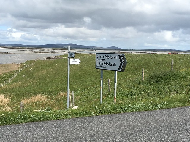
I followed the A865 over Grimsay and a few minor islands to Benbecula. I walked into the village of Gramsdal and turned right onto a track where I saw a sign for Kyles Flodda, as well as my first waymarker of the day, hiding behind it.
I followed the track for a short distance and then turned right at another waymarker, toward Ruabhal. The little Hebridean Way sign here says "Rueval, 1.4 miles." It would do better to say "Rueval, that way (good luck, kid)." The approach to Ruabhal from the north is an absolute bogfest. There are posts across the bog, but I spent most of the traverse trying to puzzle out the rationale for their placement. Perhaps this was the driest course through the bog when the Hebridean Way opened two years ago? If it was, it is no longer, although I did manage not to go any deeper than mid-shin. Furthermore, conditions on the ground did not match the map. The map in the Cicerone book shows the path up Ruabhal from the north as a straight line, when it's really more of an arc with some zigzags thrown in. .
I gingerly picked my way across the bog, hyperaware that rescue was unlikely if I went over on my ankle or fell in, since I had yet to see any other walkers and no cyclists would be coming this way. In due course I reached the far side of the bog and made it up the hill. One thing to be said for this approach is that the ascent is mostly pretty gentle. I was at the summit trig point in good time, and the weather congratulated me with a brief rain shower.
At the summit of Ruabhal:
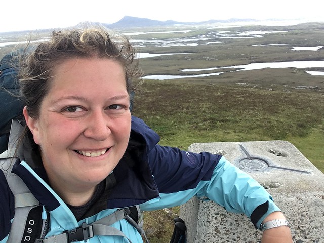
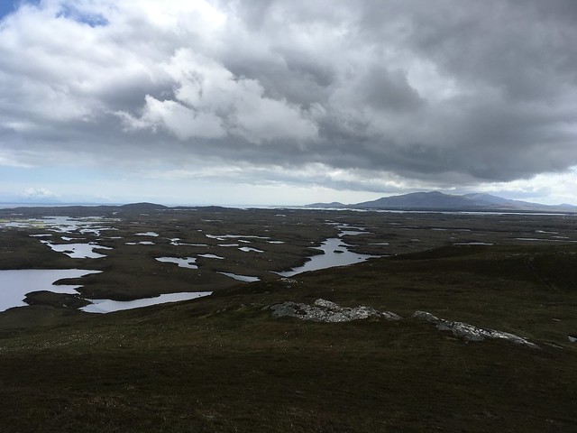
View from the summit:
I sat by the trig point to eat a Snickers, drink some water, and scrutinize the map. As I did so, I finally saw my first other walkers of the day: a party of five, walking the Hebridean Way northbound. I wished them good fortune crossing the bog and started on the very clear path descending southwest off the hill. I hit the road at the bottom and struck out west for Nunton.
After crossing the A865 again, the road forked. The left fork continued due west past a Scottish Water building. The right fork, bearing more northwest, seemed to be the one all the cars were taking. I looked on the map but couldn't find this junction, so I decided to follow the cars. At length I got to the outskirts of Balivanich and a restaurant called Charlie's Bistro, where I had an excellent scallop dish and FINALLY found the fork in the road on the map. No surprises, I was supposed to take the left fork. Oh well, I had needed to visit the supermarket in Balivanich anyway, and this way I could do it on the way into Nunton instead of having to make an out-and-back side trip.
I got the grand walking tour through Balivanich, passed the airport, stopped in at the grocery store, and continued to follow the road as it turned south toward Nunton. I passed by the moorland road I was supposed to follow earlier, and at last rocked up to the hostel in Nunton a little before 6pm. It is a fine evening, but breezy.
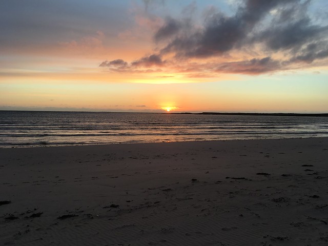
Sunset:
Song of the day: "Honky Cat" by Elton John
*****
Wednesday 5 June 2019
Nunton to Ardmore: "Abundance and Scarcity (of waymarkers)"
Distance: 8 miles
Start: 9:35am
Finish: 2:15pm
Weather: Cloudy and windy
Donald the hostel warden was spouting dire warnings of incoming inclement weather last night, but the morning dawned dry, if cloudy and somewhat blowy. I breakfasted and set off, following the road south out of Nunton until the trail diverted onto the dunes. The tide was out, so I elected to drop down onto the beach and walk along the shore. Walking on slightly damp sand had my feet rejoicing, and I had the beach to myself apart from a woman exercising her three dogs.

Rounding the point at Sithean Bhuirgh, I found a handy spot to climb back onto the dunes and followed a faint path through them toward Linaclate. Today marked my first encounter with machair - grass and flowers growing on sand, an improbable state of affairs which is almost unique to the Outer Hebrides. All the sources I've read state that I will see much more of it on South Uist.
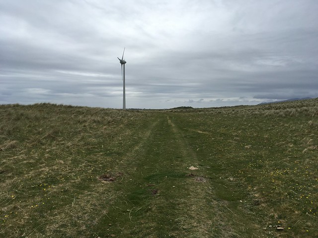
All along the dunes I'd seen marker posts at regular intervals - indeed, they were almost comically close together in places - but they petered out at the same time the path across the dunes did. The Cicerone guide uses the lone wind turbine nearby as a point of reference, so I made my way to the base of the turbine along vehicle tracks through the machair to consider my next move.
The path appeared to strike north toward the road at this point, so I headed that way. A guy (who I suspect was the same guy Bearded Wanderer met on his walk) working at one of the agricultural sheds nearby hailed me and asked if I was walking the Hebridean Way, which I confirmed. It's a bit thready, we both agreed, with either feast or famine conditions in the way of routemarking. Much of this is the fault of the weather, the man said. Marker posts get blown away in the winter storms each year. Paths get obliterated by shifting sands. Turf paths (which I've yet to encounter) sink into the bog. This led me to ponder: a walking route traversing the Outer Hebrides from top to bottom is no doubt an exciting and worthy notion; but the climate and terrain of these islands is such that creating a permanent footpath across them may be next to impossible. So what do you do? I'm not sure.
The man pointed out the Dark Island Hotel to me, where I had a room booked for the night. It was only 11:45am and my room wasn't ready yet, plus I still had plenty of energy left and the weather was holding. So I had a nice lunch and a cup of tea, dumped my rucksack, and set off just after 1pm to shave a few miles off of tomorrow's planned walk. When planning this trip, I had wanted to end this day in either Creagorry or Ardmore, but all the accommodation in both places was booked solid (and had been since last October, as one B&B proprietor in Ardmore cheerfully told me in an email); hence my booking in Linaclate, a mere morning's walk from Nunton. Looking at the map now, I saw that the Hebridean Way followed the road all the way to Ardmore, where I could get a bus back. Ezpz.
There is a footway along this bit of road, thank goodness. I was able to put on my MP3 player and just chug along, through Creagorry and over the causeway to South Uist, which the hills on South Uist getting bigger all the while.
Causeway from Benbecula to South Uist:

I reached the bus shelter at the turnoff for Ardmore just a little too late for the bus that was due at 2pm, so I had to wait an hour and a half for the next bus. No matter, I had brought a book with me and the weather was still holding.
Song of the day: "Way Down We Go" by Kaleo
***
Thursday 6 June 2019
Ardmore to Howmore: "Sail away lady, sail away!"
Distance: 13 miles
Start: 8:55am
Finish: 4:45pm
Weather: Windy
I've had difficulty falling asleep for the last few nights. The sun doesn't set until after 10pm and it doesn't get dark until nearly midnight, and no matter how valiantly I tried to go to bed at a decent hour last night, I simply could not do it. So it was a sleepy and grumpy morning, getting up early for breakfast so that I could make the 8:40am bus back to Ardmore.
Back where I left off and down the minor road through Ardmore. The weather forecast had an increasing probability of rain as the day went on, so I had put the raincover on my rucksack and it was flapping lustily in the high northerly wind. A woman in a Volvo had the audacity to beep at me when I didn't hear her come up behind me.

After walking through Ardmore I turned right up onto some moorland. There was a very faint path across the moor between two lochans, regularly interrupted by boggy ground. It was slow going as I threaded my way across until I hit a minor road, which I followed briefly before getting onto a gravel track leading to a windfarm. I walked directly underneath the three turbines and then took a short break in the lee of a maintenance building by the easternmost turbine. I took my rucksack's raincover off - so far the weather was holding, and the raincover was repeatedly threatening to turn into a sail and launch me goodness-knows-where.

A little way after leaving the wind turbines, the gravel track abruptly ended and I was once again following posts across boggy moorland.

The waymarkers were sensibly spaced and I made good progress across the moor, only going in up to my ankles a couple of times. The gravel path resumed at a bridge and took me all the way to the A865, where I turned south. I scooted along the road for a while, making a brief pit stop to visit the Our Lady of the Isles statue (underwhelming).
Eventually I turned left onto the B890 road and followed it toward Loch Druidibeg. I was getting tired of tarmac-pounding and dodging cars by this point, but there was nothing for it but to keep going. I sat down on a rock by the road for a snack, and none other than my roommate from the hostel in Nunton rolled up in her car to greet me! The B-road eventually came to a parking area by Loch Druidibeg, which was busy with wild ponies.
Wild pony at Loch Druidibeg:

I turned right onto a path by the loch shore, which transformed from gravel to dirt to mud and back to dirt again, with duckboard helpfully laid over the boggiest bits. Eventually the path resolved itself into a farm track, and I passed through a couple of gates to reach the A865 once again.
The moment I reached the road it finally started raining. The Hebridean Way crosses the road to go through Drimsdale, but I elected to turn south and follow the road directly to Howmore. Turning right into Howmore, I puzzled over two thatch-roofed cottages (one of which had a helpful "Not Hostel" sign in the window) before reaching the Gatliff hostel, nearly at the end of the road.
I had my first encounter with raised turf paths across the peat today. The photos I remember seeing on the VisitOuterHebrides website two years ago showed them as pristine, but they were looking...well-used, let's say. It had me revisiting my thoughts from yesterday about this trail. It is going to be a b**** to maintain and it is probably going to change slightly from year to year, and I just hope the Comhairle nan Eilean Siar has the resources to keep up.
Song of the day: "All the Right Moves" by OneRepublic
*****
Friday 7 June 2019
Howmore to Daliburgh: "Bug Strikes"
Distance: 11 miles
Start: 8:40am
Finish: 2:20pm
Weather: Partly cloudy and windy
Great craic in the hostel in Howmore last night. Pretty much everyone staying there was either walking or cycling, so it was a good crowd with great camaraderie.
I was on my way by 8:40 this morning, striking out for the coast on a minor road that led southwest out of Howmore.
Family portrait!

I was actually a bit inland from the highlighted route in the guidebook, which meant I was able to bypass the barbed wire fence near Loch a' Mhoil that I've heard so much about. After a while on the minor road, I picked up a good farm track heading due south, which I followed for the next several miles. The path stays inland for longer than I was expecting, but the walking was flat and the terrain was forgiving (more machair), and I was able to motor along quite happily, notwithstanding the south wind that blew at me unceasingly. I took comfort in the thought that my northbound cyclist friends from the hostel must have been having one hell of a day, in the best possible way!
I passed a woman walking northbound about halfway through the day, and about 30 minutes or so after meeting her I pulled the guidebook out to try and get my bearings. I felt like I should have dropped onto the beach by then but I hadn't. In general, I've had a really difficult time judging distances from the OS maps in the guidebook. While I was stopped, I realized that I was missing one of my water bottles. I must have left it either at the hostel or at the last place I'd stopped for a break, about an hour beforehand. Either way it was too late to go back for it, so I'm going to have to make do with carrying only one water bottle for the rest of the trip. (Side note: If anyone found a blue Mountain Warehouse water bottle at the Howmore Gatliff Hostel on or just after 7 June 2019, keep it with my compliments.)
The waymarkers are a little unclear as to whether you're meant to continue following the inland track or head out to the beach, but I really wanted to walk on the beach, so I dropped down onto the sand shortly after passing the point at Trolaisgeir. This was enjoyable for a bit...until I experienced my first-ever bug strike. Damn thing hit me right in the middle of my forehead, dead center. I gamely carried on down the beach, but the bug strikes continued, propelled by the strong southerly wind I was walking against. When one hit me right under my eye, I gave up on the beach-walking and found a handy spot to climb back up to the top of the dunes.

By now the trail food I had purchased in Balivanich was depleted and I was getting quite tired and hungry, so my thoughts began to run to the tune of "Where is this sodding golf course?" Luckily I passed my first green not long after. There were golfers about, and I considered dropping back onto the beach to ensure I stayed out of their way, but I was anxious about potentially losing sight of the communications tower that marked the place where I needed to turn inland toward Daliburgh, so I decided to keep to the dunes at the edge of the golf course as much as possible. The trail itself clings rather precipitously to the seaward side of the dunes, so it's a bit of a Choose Your Own Adventure here: beach, dunes, or golf course. I saw my second and final northbound walker on the beach below me - I'm not sure whether he saw me.
After an age I finally cleared the golf course, and easily located the path to swing inland toward the comms tower and Cladh Hallan cemetery. This is evidently a popular spot for birdwatching, and loads of people were out with their binoculars. I followed the narrow minor road south from the tower, and then turned east toward Daliburgh. I'd had enough for the day by then and didn't really fancy the off-route roadwalk into town, so I stuck my thumb out and got a lift from a nice woman in a campervan.
Song of the day: "Buffalo Stance" by Neneh Cherry
***
Saturday 8 June 2019
Daliburgh to the Am Politician Pub: "Downpour Gin"
Distance: 10 miles
Start: 9:55am
Finish: 2:50pm
Weather: Overcast with occasional hazy sunshine
Had a fantastic sleep last night and woke up feeling refreshed and energetic. After breakfast at the Borrodale Hotel, I shouldered my rucksack for my last big day of walking on this trip and began making my way back to the coast on the tarmac road. I wasn't super-excited for the mile and a quarter tarmac plod back to the trail and intended to try and hitchhike, but no cars passed me going that direction so I had to hoof it on my own. Oh well.
I got back to the trail and turned south. These were the final few miles on the Machair Way, and they were mostly on sandy farm tracks interrupted by the occasional minor road. I saw a black rabbit bounding across a field and thought I saw dolphins offshore near Orosay, but I had no binoculars so I couldn't tell for sure. I made good time and got to the Pollochar Inn, where the Machair Way ends, a little after noon. I had a nice lunch there, accompanied by the local drunkard perched at the end of the bar. By and by a large coach tour rocked up at the pub and I discreetly took my leave.
Standing stone near Pollochar:

It was tarmac for the rest of the day. There were stretches with nice, wide, grassy verge to walk on as I progressed through West Kilbride and East Kilbride toward the causeway, but these gradually narrowed away. Then it was causeway time! Surprisingly I had it to myself most of the way across, which was fortunate, as I didn't really fancy picking my way across the gravel verge. At the midpoint of the causeway I paused very briefly to look down into the water and saw half a dozen jellyfish float by.
Then I was over the causeway and onto Eriskay. I was too early to check in to my Airbnb, so I made my way to the Am Politician pub. The coach tour had passed me on the causeway and were gearing up to leave as I arrived. I jokingly asked the driver if he was following me, and he was astonished to learn that I'd walked there from Pollochar. "From Daliburgh, actually!" I cheerfully corrected him. I've seen a local gin promoted in a few pubs over the last several days, and I decided that it was high time I tried it. So a Downpour gin and tonic was how I whiled away the next hour, along with watching the staff decorate the place for a 40th wedding anniversary celebration that would be taking place later.
Song of the day: "Save Me" by Dave Matthews
***
Sunday 9 June 2019
Am Politician Pub to Eriskay Ferry Terminal
This rounded out the Eriskay section of the Hebridean Way and my walking plans for this part of the trip. The walk to the ferry dock took about 35 minutes, including a wrong turn up a road which turned out to be someone's driveway. Luckily the homeowner wasn't offended, and he helpfully pointed me through a gate which led to the Hebridean Way footpath, above Bonnie Prince Charlie's beach. Several tents were pitched at the top of the beach, alongside several motorcycles.

I had realized too late that the Barra buses don't run on Sundays, but in the waiting room for the ferry I met a large party on a cycling trip through the Hebrides and they gallantly offered me a ride to Castlebay in their support van. The kindness of strangers always give me the warm fuzzies, and I rode across Barra with the warmest sense of well-being inside. This was a great way to end my journey on the Hebridean Way.

Song of the day: "Far Side of the World" by Tide Lines
