free to be able to rate and comment on reports (as well as access 1:25000 mapping).
Back out on the hills after a fortnight watering Allison's cat and gardening. It has felt like a while, indeed it felt quite a tester for the legs going up an incline again after what has been a lengthy lay-off in my terms. I'd arranged to collect Allison from her holiday house on Friday lunchtime - with a fairly foul forecast for the weekend I reckoned we'd stick to little hills around where she had been staying. Trouble is that we are running out of Marilyns in the central areas...
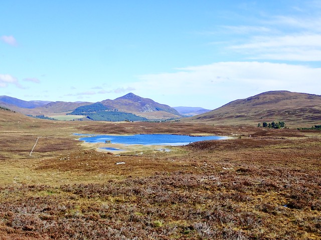
We made a beginning on Creag na Coire Duibhe, the last Marilyn in Section 4. Decided to head in from Halfway House, which - once you negotiate three streams right at the start - provides a track to get to the base of the hill. The heather has started turning a bonny shade of brown, and the view back to the pointy Graham of Creag Dhubh was pretty, particularly offset by the sapphire blue of Loch Glass Choire. The track peters out, or else went somewhere else - so we took deer tracks towards the hill, running roughly parallel to the fence. There's a gate, then a steeper pull up to the summit. From the top, the massif of Creag Megaidh sat lumpen, not a trace of snow yet. That will change very soon, I guess. Back down the same way.
 48FDC59A-5C4A-4FCF-9D3A-94392D975B7E_1_201_a
 by
Al, on Flickr
our hill
 970937DC-806A-4C81-8D1A-84C86EE31D52_1_201_a
 by
Al, on Flickr
Creag Dhubh
 4929DF41-CC85-4AE1-85B9-099838AC800C_1_201_a
 by
Al, on Flickr
 5929FCE2-529F-4E10-A6E4-5E94DBD4F19A_1_201_a
 by
Al, on Flickr
Towards Creag Megaidh
 D4F87022-5024-4039-BD34-B38212018F00_1_201_a
 by
Al, on Flickr
 A3818A7D-BCD8-437E-B6CA-D25217F0C3D3
 by
Al, on Flickr
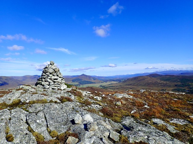
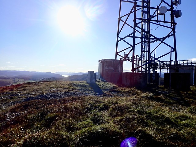
Back at the car it was time to regain the A9 and head up towards Dores. Tom Bailgeann was the chosen target - one that was missed out on a very snowy trip up here in Novermber 17 when. combination of anxiety about driving in deep snow and lack of daylight meant that we did its neighbour, Creag na h-Iolaire without the quick nip up this one. Anyway, we parked at the start of the track and set off on our way. Track gets a bit soggy higher up, the trig column is nestled behind the large comms mast. Walking a bit further to the west, there's a cairn and a good view down Loch Ness. Weather had been excellent thus far; I was hoping that maybe there would be a repeal for the flooding we were scheduled to get tomorrow. Back to the car, now with the question of where to spend the night. I drove around to Loch Ruthven, where I remembered there was a car park & visitor centre - but there's a "no overnight parking" sign up. Plan B was to walk some of the way into Saturday's hills at Dumnaglass, so we headed south towards the parking bay beside the phone box at the start of the Dumnaglass Estate road.
 4BEDE7CA-7ED5-48F8-8933-F117E0489DB6_1_201_a
 by
Al, on Flickr
 3E2C4B95-23D3-47CA-88F1-A455AC08B2AD_1_201_a
 by
Al, on Flickr
 07D7695E-E276-4A27-8C26-1DC9D21B1998_1_201_a
 by
Al, on Flickr
 9B9281E0-11AA-4E6C-A321-3576D212B0D6_1_201_a
 by
Al, on Flickr
 34AAE38C-94E2-49C8-B3FB-DB6DCB6E8149
 by
Al, on Flickr
It took a little bit of time to sort things out into the overnight packs - I'd been hoping that we might have been able to car camp tonight, but we got our kit together and set off, using the wind farm entrance for some reason, rather than the more direct route through the estate. Normally, walking down here, there's a cacophony from the kennelled dogs at the houses on either side of the road - tonight there was the merest little bark from one or two creatures only. We stopped a couple of miles down the track, finding a pleasant tree shaded spot by the river and set up the tent, bemused by the appearance of some midges - surely the recent cold weather would have sent those fellows deep into the soil to wait for next year? Apparently not. They were not too bad, and a rising breeze dismissed them while we had our tea - trying out the new Hot & Savoury offering from Huel which, with the addition of some tofu pieces, was very pleasant and a nice change from noodles. We settled down for the night, not yet used to the twilight coming at 7.30 after all the long summer evenings.
Beinn Mheadhoin
 9A5CED8B-C36A-4FB4-B341-AE98CC9F5014_1_201_a
 by
Al, on Flickr
A nice quiet night, with very little action on the road and a big bright moon. The burbling of the river soothed, as did the breeze brushing the branches overhead. The occasional screech from a pheasant, of which there were many, was the only discordant note. In the early hours the rain started tapping on the tent, but nothing more than a drizzle, even when we got up.
Today's targets were Beinn Mheadhoin and Creag a'Chliabhain, which I can only read as Creag a'Chillblain, sorry

The former hill was right next to us, the latter off to the west, across Loch Conagleann. We took a track up the north side of the hill - this enters a deer-fenced enclosure via a gate, but there's an awkward fence to climb over to exit onto the hillside higher up. Then you pass a number of rather derelict gross butts before arriving at the summit. The wind farm to the south west appears from the top, none of the turbines turning today. We descended on the western side, where it appears that a new fence is soon to be constructed, and joined the wind farm track heading north along the Allt Uisg an t-Sidhean (the Fairy Water, if I'm not mistaken) - this needs to be forded to reach the boat house at the southern end of Loch Conagleann. A track runs from here round the corner of the loch and cuts through the bracken to reach a number of pheasant feeding stations on the hillside - legions of the birds coming and going at our feet.
Creag a'Chliabhain on the right
 8CD8D054-2480-48B4-B78E-FF116157E7D9_1_201_a
 by
Al, on Flickr
Mheadhoin summit, wind farm behind
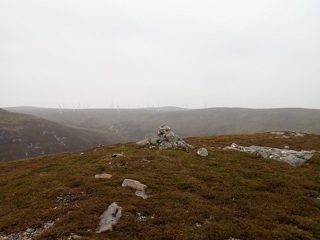 B25ABC27-334F-41BC-9387-18A819CA849A_1_201_a
 by
Al, on Flickr
 1A835DF5-BEDF-4D11-9F73-17F9170718F1_1_201_a
 by
Al, on Flickr
 D57A5794-4428-4096-B5DC-08E17DDDA5AA_1_201_a
 by
Al, on Flickr
Towards the boat house
 C4B86FC5-512B-4B91-97DE-852342299CF8_1_201_a
 by
Al, on Flickr
Heather tramping is required now to reach the ridge leading to a rather impressive rocky outcrop before the summit of Mount Chillblain. There's an ATV track leading to a gate through the deer fence then a soggy squelch to the top. You could, I suppose, stay on track if you came in from Errogie, but the best bits of this hill are missed by accessing from that direction. Anyway, we continued onwards, my plan to cut down to the south being hampered by mist and some significant crags - we ended up taking a good ATV track down to the sheep field and managing to get through the deer fence by means of a proper gate rather than a climb if we'd gone my original way. Back on track to the car, a few more dogs wailing at us as we went past this time.
Chliabhain
 34894166-06F5-490C-8DD3-6644B0FF6A2B_1_201_a
 by
Al, on Flickr
 016AC455-5F6C-4B88-983F-4B7BBC618287_1_201_a
 by
Al, on Flickr
Summit
 9A7BD144-28B5-4C5E-A3CE-C6A062915677_1_201_a
 by
Al, on Flickr
 5EA4E9FC-2133-4F0E-BDEC-C400A03FF47A_1_201_a
 by
Al, on Flickr
 862323D8-0E46-4A5B-92AC-0AD183DCE3ED_1_201_a
 by
Al, on Flickr
 9A2B8535-331C-48EB-8ABB-12893834DE7F
 by
Al, on Flickr
It was still early in the afternoon and although we were somewhat weary with the effects of the big rucksacks, after several weekends without, we could manage another wee hill. Meall an Tarsaid, down the road a few miles near Whitebridge. I'd explored several options for this one and had decided on the shortest route, utilising an ATV track. We parked at a double passing place just at the field where the track begins. It isn't much of a track, disappearing in long grass then becoming very muddy. Anyway, it leads to a double deer fence, which is quite an obstacle. We found that the first fence had a hole in it, patched up, but easy enough to open up again to permit access, the second fence easy enough to climb. After that you are into a native tree new plantation, with very closely planted beech trees to start with, steep heather clad slope and it takes quite a bit of puff until nearer the summit. The first cairn reached is lower than the more southernly cairn, helpful to know in advance when clag prevents you from seeing any other parts of the hilltop. Back the same way, repairing the gap in the fence we'd re-opened.
 DE4E55A7-1A71-4E2A-B92B-ACE6BEC87975_1_201_a
 by
Al, on Flickr
 42E089CC-C48A-49A1-9540-2E230BD4FFAA_1_201_a
 by
Al, on Flickr
 57171685-80F5-40D4-9342-C7AC99DDCC05_1_201_a
 by
Al, on Flickr
 24E1B0CD-D7FE-4A86-89F9-2EFACC230522_1_201_a
 by
Al, on Flickr
 AFB7B13C-A09B-4B77-8A40-EC83B3BB9FBC
 by
Al, on Flickr
Next question was what were we going to do tomorrow and where would we pitch tonight? I'd thought about round Loch Tarff, but all the parking spaces were already occupied (at 5pm ish) by camper vans. So we ended up just off the road nearer Fort Augustas - not the best spot ever but it sufficed for a rainy night. And it rained, all night long. No moon to ease our sleep with silvered light tonight.
What would we do on Sunday? In the rain? I had a look at our nearby options, which amounted to very little - we could head up the other side of Loch Ness for Meall na h-Eilrig, but it seemed crazy to be going in the opposite direction from home, plus I found I hadn't made a route for that one. We decided to get Drumcroy Hill done, my last Perthshire Marilyn. Not a very exciting hill, nor a very long one. We returned to the A9 and took the little road to Trinafour, where we'd once, very early in our camping career, found a place to pitch overnight - as we thought, in the middle of nowhere, then been kept awake all night by a crew of engineers fixing a railway bridge just beside us. And then had a flat battery and needed to call in Green Flag

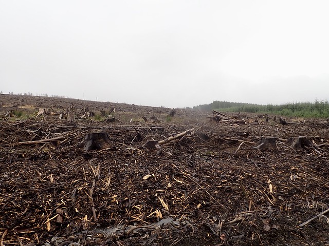
None of that today, just a nice run on quiet roads to the strangely named Over Bohespic where a forestry track gives access to the hill. There's room to park at the opening of the track, but there are forestry works going on at present (though not on Sundays it seems) and we walked past signs saying no admittance. There's a large area of fairly newly felled trees - the route I had plotted had made use of a fire break through here - but there was only a post apocalyptic landscape. We did make for an old wall, which provided easy walking along the edge of the felled destruction and brought us right to the cairn where we stopped for a bit of lunch. The rain had largely abated by this time and we decided to head home. Seven Marilyns until my 1000th - I can hardly contain my excitement

 AA0F8745-ABC5-4986-B07F-65352B691AB2_1_201_a
 by
Al, on Flickr
 42602EE5-60ED-4430-A7D4-628EDEDA3BC1_1_201_a
 by
Al, on Flickr
 47FCF2C9-DD3D-4D9A-8DD9-36A5396F3FDE_1_201_a
 by
Al, on Flickr
 314DDE92-63B9-44F1-915A-A78570344958_1_201_a
 by
Al, on Flickr
