free to be able to rate and comment on reports (as well as access 1:25000 mapping).
With a moderately good forecast I decided it was time to get back up the West Coast - there are a number of Skye Marilyns undone. In fact, there are a surprising number of Skye Marilyns with no walk reports, including six of those we did this weekend. I find that surprising - Allison just says that it's Skye, people come to do proper mountains, not wee piddly hills.
We had a fine drive up - no traffic in front except for the section between Ballachuillich and Fort William. Given that it's now dark early we chose to camp in Glen Shiel and drive over to Skye in the morning. My preferred location was a bit awkward to find in the dark - we passed the little turn up and had to go back, but no-one else was there, which was a relief. In the old days I used to camp just before the Cluanie, but that's now a regular campsite, it seems. Anyway we bedded down with the diminishing road traffic and the undiminishing stag roaring to keep us company.
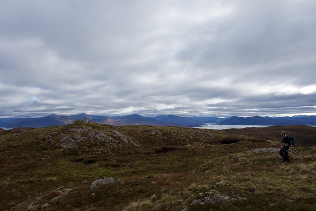
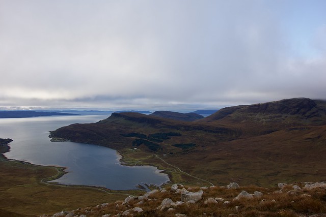
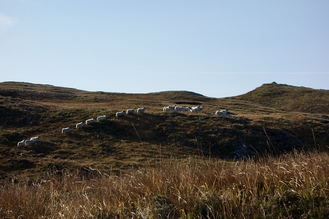
Up as early as we could be bothered the next morning and on to Skye, roads quiet. The choice for today was the three Subs on the Sleat peninsula, Sgurr an Caorach; Sgurr na h-Iolaire and Scorach Breac. We drove down past Armadale and onto the little road past Ardvasar. You could head to the end of the road where there's a parking area and just rough it over the moorland, but I decided to use track going through the community woodlands, mostly felled. There's ample parking here and good track to begin with, although it tails off into boggy ATV style track after a while. Good views over the Sound of Sleat to Loch Nevis as we began the walk, then Eigg and Rùm appeared. The sea was millpond calm, with that lovely glossy sheen where the sun struck it. I took a bit of a wrong turn through the trees and ended up having to clamber over the fence onto open hillside, but as we gained height the Red and Black Cuillin began to appear. Sgurr nan Caorach isn't much of a hill, but it has some fantastic views and would make for a fine summit camp, as is the case for a number of the hills we climbed this weekend.
 2E2DE441-BFF6-44DD-8F0E-882A140342A9_1_201_a
 by
Al, on Flickr
 1CB143C5-4636-4BFB-BE9A-755568B4EBAD_1_201_a
 by
Al, on Flickr
 1938C273-9A69-4C9B-99C9-87305E2B6903_1_201_a
 by
Al, on Flickr
 25DB6815-D1A6-4D8E-97B9-C7FCB7FB8952_1_201_a
 by
Al, on Flickr
 464EB86E-BB2A-4291-BEDA-9BA5F6FD1100_1_201_a
 by
Al, on Flickr
The trig column isn't the summit, as you might interpret from the WH graphic, it's a little cairn quite some distance away. We hung around for a while enjoying the scenery then started back the same way as we'd come, only managing to locate the gate through the deer fence this time. I heard voices - these belonged to an Edinburgh couple who were on holiday doing Marilyns - they were planning to do the other two in Sleat as well, and we met them on each.
464EB86E-BB2A-4291-BEDA-9BA5F6FD1100_1_201_a by
Al, on Flickr
 892CD4FD-141F-4F0D-B676-8F59D93201FB_1_201_a
 by
Al, on Flickr
 12D403C7-3982-4131-BB9C-FBA5FA234DCB_1_201_a
 by
Al, on Flickr
 5B09CA3D-6B31-475C-BBF2-DF79EC54AEF1_1_201_a
 by
Al, on Flickr
 D8522B95-1868-4C95-A828-9F367F9F2D82_1_100_o
 by
Al, on Flickr
Back at the car we set off to do Sgurr na h-Iolaire, which is on the windy road from Kilbeg to Tarskavaig - a nice wee circuit if you like hairpin bends and sudden plummets. The best spot to climb it from is the west end of Loch Dhughaill - there's room for one, or maybe two cars to park at the dam outflow. Animal tracks head around the loch, there's a barbed wire fence to climb, then it's just up the hillside to the summit. More breathtaking vistas.
Sgurr na h-Iolaire
 10BB661E-64BE-4B75-A626-DD0734DE597D_1_201_a
 by
Al, on Flickr
 0031AF23-4A53-4F23-9228-B8923A82CD33_1_201_a
 by
Al, on Flickr
 FCE87B56-0C69-48D8-8A65-90AEB71875D0_1_201_a
 by
Al, on Flickr
 6D519DDE-02A6-47A3-8E00-7FB0C1CC9B5C_1_201_a
 by
Al, on Flickr
 EF3407AA-402E-47F1-AB69-C67BC7CFF5C7_1_201_a
 by
Al, on Flickr
 5AF55608-8DDC-47F8-969A-BB4F7041ACE5_1_201_a
 by
Al, on Flickr
 601A1EFA-237D-4357-85FF-9311549E70F3_1_100_o
 by
Al, on Flickr
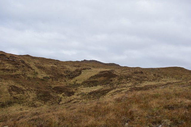
Hill number three was on the return road from Tarskavaig. There's parking for a few cars on a flat bit of ground beside a passing place at the 113m spot height. We took a line up, keeping the fence to our left, then aiming at the summit - the trig column being visible from well off. There's a soft, rather boggy ATV track going much of the way up. Probably the least scenic of the three hills this one.
 2E432307-CAF1-46E7-A94D-D00917087E7C_1_201_a
 by
Al, on Flickr
 5842AE6F-6D07-4FDD-98A0-5A9EB4C39239_1_201_a
 by
Al, on Flickr
 ADDE7604-564B-434B-B8DE-6F089A4E314B_1_201_a
 by
Al, on Flickr
 00AB1945-1BB3-45EE-B111-587442AC8BA3_1_201_a
 by
Al, on Flickr
 18354C02-60C8-443D-89D3-6557500FEA06_1_201_a
 by
Al, on Flickr
 A92F2C51-47FC-4A57-A838-AA0944B67664_1_100_o
 by
Al, on Flickr
We met the Edinburgh couple parking as we got back to the car. Got a tip on best route up Beinn na Seamraig, which I had originally planned to start today. However, it was getting on a bit and I thought we might camp at the foot of Beinn na Cro, which meant that we could head to Heasta for the short haul up Beinn an Carn first. I hadn't been down that road before - advice was to park at the sheep pens at the north of the village and head uphill. Which we did - there's parking for a couple of cars at the start of the route, a small stream is easily crossed and cattle tracks lead along the fence line and onto the hillside. Heather and tussocks to be negotiated then a pull up onto the flatfish summit. I was regretting not bringing the camping gear as this looked another fine spot to watch the sun go down; the Cuillin on the right, Rùm ahead. But we had left the gear in the car so we descended and drove along the Elgol road to the head of Loch Slapin. This is another area that's become a de facto campsite - we spotted a number of vans and tents along the flat stretch at the head of the loch. We were fortunate to find a good spot just before the bridge, in fact just where we'd set off in the morning for Beinn na Cro. Another guy arrived to car camp on the opposite side of the bridge, and a young couple were having a tent experience with deck chairs a little further along. But no noise from anyone, just the occasional passing traffic and the inevitable roaring stags from various hillsides.
 11710B77-5AF1-4C84-BBEF-A0B978013D0D_1_201_a
 by
Al, on Flickr
 B62AD235-42D3-4288-A2B5-EC31E3B022F8_1_201_a
 by
Al, on Flickr
 30EE4786-EE05-4D83-9B95-A78338E593CF_1_201_a
 by
Al, on Flickr
 9A70DEB9-DCB6-4843-BD82-EE35EC4C1A2B_1_201_a
 by
Al, on Flickr
 50C69239-DD93-42B1-8C1E-63F0CC1B8404_1_201_a
 by
Al, on Flickr
 0C9146AA-A308-4412-9E79-0A8CE609249D_1_100_o
 by
Al, on Flickr
Beinn na Cro
 E6F318B2-3B33-4C14-8609-866943554FC0_1_201_a
 by
Al, on Flickr
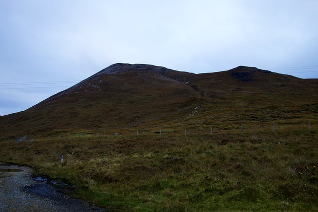
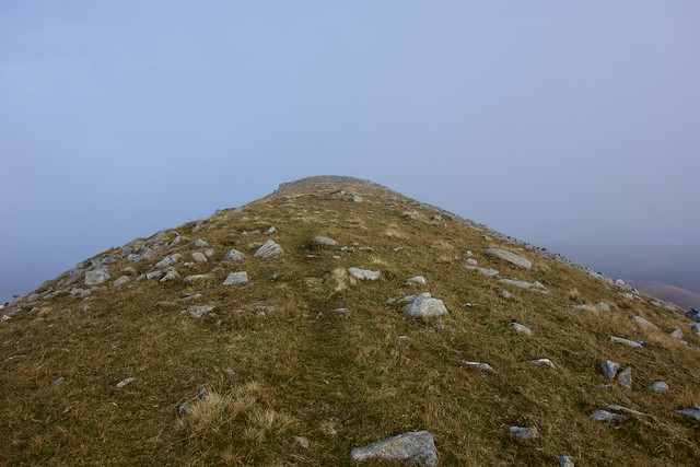
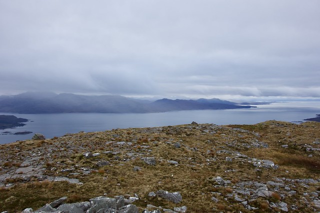
Cloud was down on the tops when we got out of bed - the haul up Beinn na Cro was straight forward - there is a good path heading right up, so I guess this isn't one of the lesser climbed hills of our weekend. Just a steady climb of 550m from sea level. The clag was down on the last 30 metres or so, which prevented good views from the summit, but it was looking like it would clear soon. Not fussed - have seen the views from here from a number of the surrounding - and higher - tops.
 1854403F-E65C-484D-99B9-A97025BB92D6_1_201_a
 by
Al, on Flickr
 111741B5-0926-43FD-BBE5-A5521E6B8D49_1_201_a
 by
Al, on Flickr
 51E3CB1E-B270-4D44-BEDF-CCA9C90C9911_1_201_a
 by
Al, on Flickr
 389454F2-8A3B-48DF-B58B-E6B97CE75E3F_1_201_a
 by
Al, on Flickr
 E0A2DA35-DD39-4983-96E6-40FAAD1D6030_1_201_a
 by
Al, on Flickr
 9770F363-0455-4D01-8243-B86679D3C59F_1_201_a
 by
Al, on Flickr
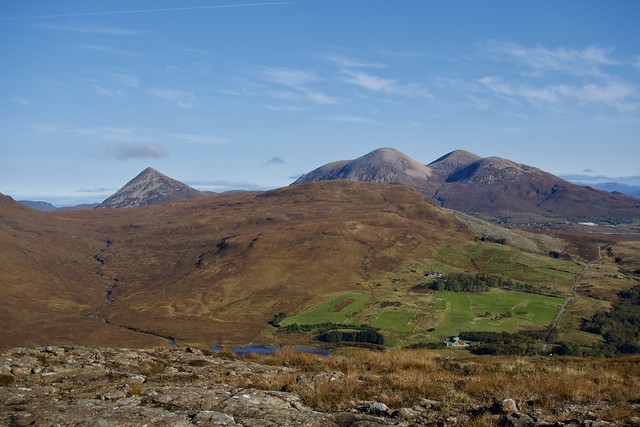
Back at the car we headed a few miles further along towards Elgol so that Allison could climb Meabost, which I'd done a couple years ago. I'm glad we did as it was a crappy day the last time I was there with poor views, and the views from Ben Meabost are well worth savouring. In fact, it would make a very good summit camp

have I said that before

The ochre of the spent hillside grass provided a contrast for the gleaming grey of the Cuillin ridge; the spire of Gillean dominating initially til the curved prow of Gars-bheinn appeared over the topaz of Loch Scavaig. Sgurr na Stri sat before it - a hill we can only do if we arrange a summit camp there in perfect weather

May be a while then... We lunched at the top then made our way back down.
 BA8CA48F-351B-4284-9D14-9056E2D50AFE_1_201_a
 by
Al, on Flickr
 12CDED03-B675-41C7-89ED-EED628E1AB67_1_201_a
 by
Al, on Flickr
 B2838BA2-D023-4AFD-ABF2-71C7A24A6AF4_1_100_o
 by
Al, on Flickr
 4AC45C9C-6520-4A22-A94C-82DBC1590D01_1_201_a
 by
Al, on Flickr
 75652304-9314-4627-B9EA-EAA8561F563F_1_201_a
 by
Al, on Flickr
 39B54BCF-6800-41E5-AE7C-F87721E1A72B_1_201_a
 by
Al, on Flickr
 BE4EBAB4-B9F1-4D0B-AE69-81D90EA1B713_1_201_a
 by
Al, on Flickr
 2505B305-6737-48B1-982C-BEAD94305890_1_201_a
 by
Al, on Flickr
 7CC1DF06-ACAD-4722-A2BC-B4D6A0AA6ADE_1_201_a
 by
Al, on Flickr
 6AF7C6D0-9493-4BF9-8D2A-36FC3361A521_1_100_o
 by
Al, on Flickr
I had a few hills to pick from for our next one, but as most were up the central road towards Dunvegan I chose Sithean Bhealaich Chumhaing, which was out on its own on the Portree side. Motored up past an empty Sligachan campsite (covid closed this year), through a bustling Portree and down a wee road to Torvaig, where we parked at the start of a footpath to the Nicolson's Monument - room for one car only. Up past a farm, along to the monument which marks the spot where the head of the Nicolson clan resided for eight centuries, then quite steeply up the hillside to the cliff top path. Great views across to Beinn Dearg and later, to the utterly primeval sight of The Storr and accompanying needles, with wisps of cloud hanging about to provide extra atomsphere. It would have been no surprise had a couple of archaeopteryx flown around - although we did see a pair of sea eagles glide over the trig column on our own hill. Out to sea, the long bony body of Raasay stretched out like some fossilised serpent, with a reminder that there's a Marilyn at the far end of it waiting to be done. Someday. We enjoyed the cliffs as we wandered back, with the unique form of Ben Tianavaig beyond.
 42037C9B-8F48-4D5E-BAE2-A6F5D6AD0FDA_1_201_a
 by
Al, on Flickr
 C3F99E7A-5585-4DA1-AB9B-95C584EE5D7B_1_201_a
 by
Al, on Flickr
Ben Tianavaig
 903C89B8-81F4-4240-81FF-89BA4B9D36FA_1_201_a
 by
Al, on Flickr
 8CBD9013-E90C-4645-89F6-C3F1B289FC1A_1_201_a
 by
Al, on Flickr
Long long Raasay
 00823DBF-ED89-41D7-BCB6-4EAD00555F56_1_201_a
 by
Al, on Flickr
 6100694D-C847-4BE4-8B7E-5B37267C47BE_1_201_a
 by
Al, on Flickr
 4316098F-9459-4F89-83B3-D9E1C9742691_1_100_o
 by
Al, on Flickr
 605158C5-27B5-47B1-9E80-026C7AB4B19B_1_100_o
 by
Al, on Flickr
 00ADE6CE-0BF8-45A0-9F07-44299FA14181_1_100_o
 by
Al, on Flickr
 F52031EC-E4EE-4B37-82C0-5EB9F1B719E4_1_201_a
 by
Al, on Flickr
 882D36F6-E25E-4BAD-98B3-1A3EE15DD1B0_1_201_a
 by
Al, on Flickr
 76AF23E1-8302-497D-84EB-F3CB6FC39F50_1_100_o
 by
Al, on Flickr
Then it was a drive back to the south of the island, just a couple of miles (thankfully) down the Kylerhea road for Beinn na Seamraig and Ben Aslak. I'd done the latter when we did the Kylerhea Grahams. It was getting late by the time we arrived, parking before the cattle grid on the main road (although you could drive 100m or so up the forestry track to where there's a large sweeping corner that you wouldn't impede with a vehicle). We assembled our overnight gear and set off into the late afternoon sunshine, intending to camp as soon as we found a suitable spot and do the hills tomorrow without carrying any extra weight. Finding a spot wasn't that easy - lots of heather tussocks, with varying degrees of wetness under them. Walked for a couple of kilometres til we decided it wasn't likely to improve and chose an acceptable spot. A clear night for a change. We looked out over the water - the erratic twinkling of different lighthouses on the mainland coast to Plockton and from the Crowlin Islands then the stars started to come out - the Milky Way above us, scintillating stars, a glorious sight. Bits of cloud swept over later on to keep the temperature from plummeting. It was so nice to be away from any traffic noise, nor was there any stag roaring - only once during the night did a distant roar sound through.
 D202C4F7-03A2-453F-9E1C-0EFA3F73D703_1_201_a
 by
Al, on Flickr
 03A041DF-66C3-49BE-AADF-F09E14924281_1_201_a
 by
Al, on Flickr
 FDCC1901-F2C0-4D48-98E0-EA45CE1AE626_1_201_a
 by
Al, on Flickr
 479B0B2F-0ABE-4426-B101-CE842479BE0D_1_201_a
 by
Al, on Flickr
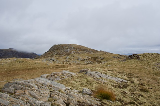
Morning came around, we were quite well rested and after breakfast set off leaving all the kit with the tent. Up to the end of the track where - Mr Edinburgh had told us - there is an ATV track heading up Seamraig, which there was, making the going easier through the bogs and tussocks. Although the day was more overcast, we still enjoyed the views, mist smothering the jagginess of the Cuillin range, bands of rain sweeping over the Rough Bounds. We, on the other hand, stayed pleasantly dry, though it was nippy in the wind. Summit of Seamraig reached, we descended to the bealach and made our way up Aslak, picking out a line through some crags to reach the stony summit. Good views down to Sandaig. Back to the track over soft and boggy ground then back to collect the tent and our gear and return to the car.
 FDDE24AE-9185-4776-B7DE-E3228307071C_1_201_a
 by
Al, on Flickr
 315806BC-9E8D-48A2-BCE0-988C3DAAC24C_1_201_a
 by
Al, on Flickr
 74DEEAB5-6D08-414E-96C6-BECCCBC32FFA_1_201_a
 by
Al, on Flickr
Seamraig
 69571D30-84AF-4C3F-8A42-A722FB10EF63_1_201_a
 by
Al, on Flickr
Rain over Knoydart
 59B6A2F1-8742-40F5-9AE4-7CAF36A56349_1_201_a
 by
Al, on Flickr
 8F09C194-9615-4903-A533-19B63E564B50_1_201_a
 by
Al, on Flickr
 2CA8C034-21FF-4AEE-AB61-8F3AED9DA0B1_1_201_a
 by
Al, on Flickr
 218B721D-20CD-4CED-9EC7-3C3A791D03A3_1_201_a
 by
Al, on Flickr
 FD90F882-F24B-46B0-89C4-D8747F2196F6_1_201_a
 by
Al, on Flickr
 5C912B83-8134-4FF0-A75D-5BB7396EADDD_1_201_a
 by
Al, on Flickr
 91CC78CB-3CA4-4D1A-A170-C7B197192B6E_1_201_a
 by
Al, on Flickr
Sandaig
 5BABEC46-D169-4DC9-B646-FF546948D901_1_201_a
 by
Al, on Flickr
Aslak
 27E81518-3C46-4B39-B684-1D0351224153_1_201_a
 by
Al, on Flickr
 E034904F-7561-402B-9FE6-12841F47C4C2_1_201_a
 by
Al, on Flickr
 1A817D8B-A47C-4117-9765-71B4469A7D6A_1_100_o
 by
Al, on Flickr.
