free to be able to rate and comment on reports (as well as access 1:25000 mapping).
Having enjoyed the best of Skye weather and views last week it was inevitable that we could expect misery on our return. The forecast was pretty dire, especially in the west but I couldn't really be bothered going elsewhere - I was in the zone to get most of the remaining Skye subs in the bag. Had planned to do those in the North part of the island on Friday/Saturday morning then head over to Raasay for Beinn na h-Iolaire. We headed up on Thursday night, once again availing ourselves of a camp spot in Kintail. Much soggier ground than a week ago and no a single roaring stag heard overnight, a contrast to the same place a week ago.
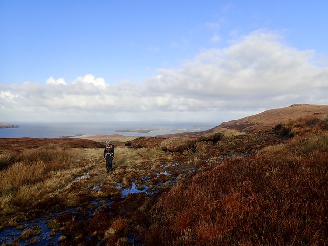
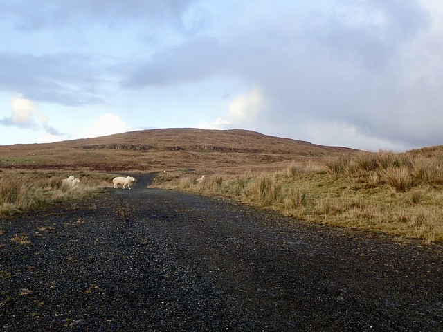
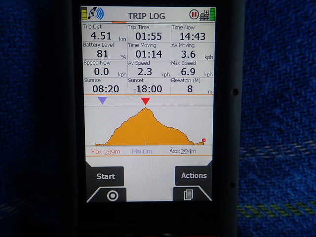
Forecast for Friday was for sun and showers. We drove over the bridge then up past Sligachan towards Dunvegan - Beinn Geary was to be first on the list. However, having stopped off at the toilets in Dunvegan we found ourselves headed for Cleigan - having missed the road for the top of the Waternish peninsula. Och well, we can do Beinn Bhreac from here anyway - it was to be hill number 3...We parked at the Coral Sands carpark at just after 10 - some folk heading to the beach despite the rain. (Distance 5.5k, Asc 289m ) We walked along the farm track, through sheepfields, pleased that the weather was drying up, even some sunshine to enjoy the views towards McLeod's Tables. We parted company with the track eventually, having to humph over boggy tussocks towards the summit, and navigate a particularly boggy section just before the final rise to the top. On descent we followed an ATV track, hoping to avoid the worst of the bog but in fact this simply prolonged the squelch. Dry feet again on the track and a return to the Coral Sands car park, which was by now absolutely heaving with another 5 cars and a camper on their way in - God knows what it must be like in peak season. Some dick in a camper van soaked Allison by driving through a large puddle rather than wait for her to pass - sadly it took too long to navigate our own exit from the parking spaces to exact any retribution.
An un-busy Coral Sands Car Park - not for long...
 1DD9B5E5-4161-4265-AA5E-5BB2EF1958AE_1_201_a
 by
Al, on Flickr
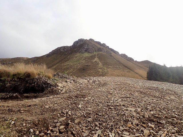
Beinn Bhreac
 2B771CF2-E68E-4C8D-B380-202C83C2759C_1_201_a
 by
Al, on Flickr
 F78468FC-7BD3-4E9C-A5F0-FD8EC575C162_1_201_a
 by
Al, on Flickr
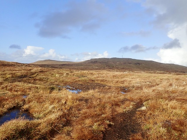
The Tables
 59D3E207-D6AE-4F8A-A0E8-342600587B1D_1_201_a
 by
Al, on Flickr
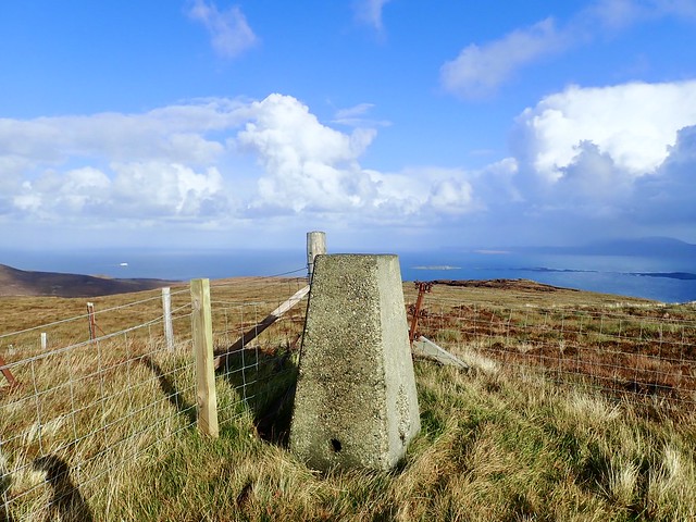
Summit
 A20C62A5-B150-4C6B-9C87-242F040ED0A7_1_201_a
 by
Al, on Flickr
Instead we drove back to Dunvegan and took the correct road to get to the B886 and arrived at Geary, where we parked in the school car park (school currently closed, probably still half term up here?). It would also be possible to park just inside the entrance to the track one walks up the hill upon. The track is reasonable, wet and boggy in places, but does the job, reaching the comms mast right by the summit trig column. On a better day we'd have walked over to the cairn that marks a blacksmith's death in one of the island feuds, but the wind was wild and the rain was on the way. We trotted back the way we came.
School
 EE87D2A8-37AC-43E7-984A-82ED0DB689E5_1_201_a
 by
Al, on Flickr
Beinn Geary
 A26DACA0-E24E-4ED6-983F-C9AA8B7D457D_1_201_a
 by
Al, on Flickr
 5857D5C5-7F16-45AF-99B1-3C410668A58A_1_201_a
 by
Al, on Flickr
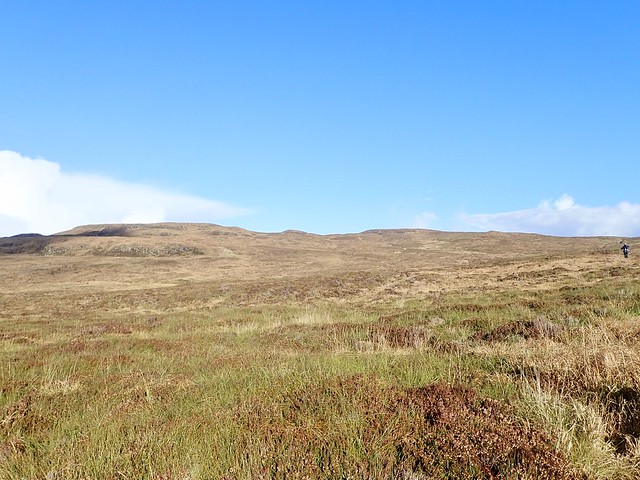
Hill 3 was the worst of the day. Beinn Chreagach. Comments on Hill-Bagging included "unrelenting slog" "truly appalling terrain" and "somewhere between irksome and purgatorial" There are no tracks - well that is a lie, there are animal tracks but the deer who left them seem unconcerned with reaching the summit. We parked at the Fairy Bridge, where there's a number of parking spaces and walked along the road a bit, til we saw what looked like deer tracks heading into the tundra. They were, but they stopped after about 3 metres. Then it was knee, sometimes thigh-high tussock, soft underfoot, generally awful. There's a stream to cross (brighter idea might have been to just follow the north bank of this stream, the Allt nam Maighdean from the roadside). It became a little easier as we got nearer the top, but it was one of those tops that always was a little further away. Saw our first Rainbow fragment of the day as we neared it. We took a different line back down, which used more of the animal tracks but was probably only easier because we were descending.
Fairy Bridge
 485CB14B-AF23-4281-977D-0CCF7E836ABD_1_201_a
 by
Al, on Flickr
Where's the rest of it?
 99AC0A59-1315-45E3-B4DD-DA731F3B8B5E_1_201_a
 by
Al, on Flickr
The hell that is Beinn Chreagach
 A3E46E00-113C-4D58-ACF1-3C3A4955986B_1_201_a
 by
Al, on Flickr
 330032CC-FC07-4D34-BC0A-56DEBC992B4E_1_201_a
 by
Al, on Flickr
 12A8D1F0-AB7D-401B-867C-DEDD0EA82E8A
 by
Al, on Flickr
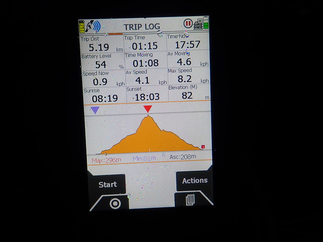
Time was getting on - I wanted one more hill for the day, Cruachan Glen Vic Askill which was mostly on wind farm tracks - then we had to figure out where to camp for the night. We drove down to Balmeanach and continued past the (mostly) holiday lets onto rough track through some woods that leads to a power station, where we parked. (there was nothing to stop us driving to the top of the wind track had we wanted - there's a large tarmac area there to turn should you wish to do so) A straightforward jaunt up the good track, past inquisitive sheep then less than 1km on wet grass to the summit where we could see another broken rainbow fragment falling into the sea. Back down we went to the car. It was about 6pm by now, still dry but the sky looking ominously dark. We decided to chance it and pitch just down from the power station beside some ruined sheilings - sheep about and evidence of cows too...finding a piece of ground free from cow pats was a challenge in itself. Anyway we managed, got set up before the rain started. And did it rain...the wind picked up coming straight at us from the sea and we were rain lashed and wind whipped all night - not much sleep was had, I can tell you. We did hear some distant lowing of cows in the mid-evening but only once and they didn't sound near, so our fear of being squished by bovine bodies as we slept didn't rise too much. Fortunately we'd pitched the Nammatj which is the most robust tent we have, so no worries about it withstanding the elements.
 B96F769B-85BB-4D7E-86E2-8E0907AA8397_1_201_a
 by
Al, on Flickr
 4EEC4E5B-75A4-4EA7-BB05-3742CCF322F6_1_201_a
 by
Al, on Flickr
 E6A324EA-C20F-4B1F-81BD-CE0207CF4D64_1_201_a
 by
Al, on Flickr
Maybe a pot of gold nearby?
 3D98CDF7-2889-4106-BD14-402033BD23C0_1_201_a
 by
Al, on Flickr
 FD7AEDD5-72F8-49C1-81C0-21813E292049
 by
Al, on Flickr
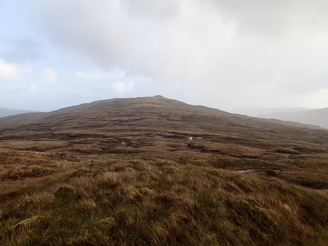
A brief period of dry weather allowed us to pack up in the morning and get on our way for Beinn na Greine. This hill sits to the SW of Portree and it could be done from that side using forest tracks but I think that it's more easily approached from the west. This involved driving the rather dramatic B885 road crossing the interior of the island and revealing a very different Skye - dun coloured expanses of peat and water, the mountains to the south obscured by mist and rain. Then onto an even smaller road towards Glenmore, where there's a surprising number of houses. Parking at the entrance to another wind farm, we were already at 200m elevation - a pronounced advantage on the sea level start from the other side. Up the track, then once Skriag is reached there's a descent across boggy ground followed by a steady climb up to the turreted summit of Beinn an Greine. A good viewpoint on a better day - the Trotternish ridge and Ben Tianavaig, then the heart of the red and Black Cuillin to the south. We returned by the same route, taking the trouble to summit the TuMP of Beinn Skriag first.
 2C29AC5F-09BF-45D2-B2D9-1DF8FA39B073_1_201_a
 by
Al, on Flickr
 66B35169-CC40-4BCF-8952-035D279214E1_1_201_a
 by
Al, on Flickr
 90C5BF84-AC4C-41F7-94F9-44564F2DEA69_1_201_a
 by
Al, on Flickr
Beinn na Greine
 9BB9A51E-C1C7-4F91-8CCB-77C8DFC10504_1_201_a
 by
Al, on Flickr
 D701AC95-3466-4F7C-9B6C-FE5C933CBEF5_1_201_a
 by
Al, on Flickr
 30F535B2-C9A2-42F8-A2F5-494998DEB6FB_1_201_a
 by
Al, on Flickr
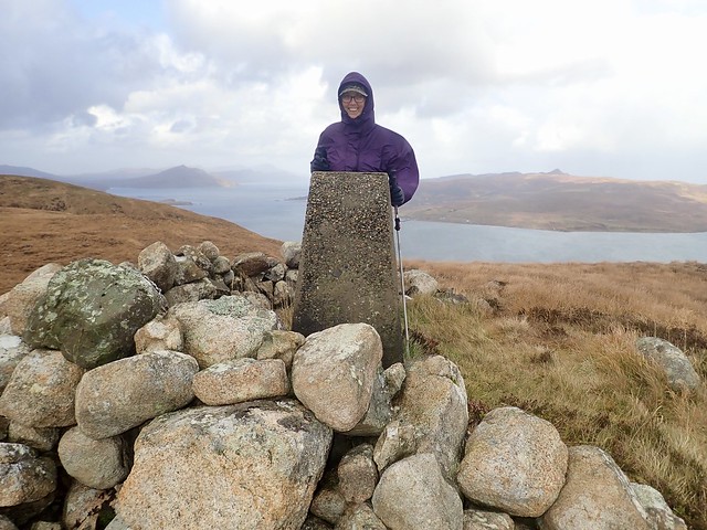
Our plans for Raasay had been shelved - although we could have taken the car across and climbed Beinn na h-Iolaire we both wanted to walk there from the ferry, a return distance of some 38km, although that's almost all road and track. But not in today's weather. So we headed round to Portree to check the weather forecast and consider our other options. It was here that I noted an email from Jacky on Eigg saying she assumed we'd cancelled our stay because fo weather conditions. I was mortified. This was the weekend we were meant to have been on Eigg! And of course you have to book accommodation to be allowed to travel there at the moment. I was convinced that it was next week - I'd been saying that we'd be on Eigg for Halloween. How embarrassing. However, I emailed her back and she was very nice about it. But I checked the ferry situation and was suddenly greatly relieved that we hadn't gone - we would have got there on Friday alright, but the Small Isles boats were cancelled Saturday and Sunday, which meant that we'd have been stranded there until at least Monday if not longer as there's another storm system coming in from the west.
We decided in any case to do Meall a'Mhaoil, which sits on the coast just after Sconser. I'd done it a couple of years ago on my own - this seemed a good opportunity for Allison to catch it up - we couldn't do any of the more interesting (ie higher) Skye peaks due to the very strong winds. So we parked down by the quarry, considered a couple of options for the route and ended up using the line I'd taken last time, up by the tree line then onto open hillside. This is a fairly awful hill too - the going is hard underfoot. The strong winds didn't help. Across from us the Red Cuillin looked grim as a dark sky moved across them - this unleashed a fusillade of hail at us which was intensely sharp - we had to crouch down to protect the backs of our legs from being pummelled. I suggested to Allison she think of it as an expensive spa treatment - I don't think she was convinced. On to the summit, then we took a different line back down, looking to find a track that's marked on the map which runs through the trees. We did find it then lost it almost immediately, heading along deer tracks instead, which was marginally better then the way we'd gone up.
 649601EC-D1D3-46ED-90F9-E7429E0A658D_1_201_a
 by
Al, on Flickr
 CEC43729-B836-45D1-831D-BD33182FD49F_1_201_a
 by
Al, on Flickr
Glamaig
 E46BA2A6-03C0-46A1-B820-A54D17DA48B3_1_201_a
 by
Al, on Flickr
Another fragment!
 99B56FCD-FECD-4DAD-9736-D5317E831394_1_201_a
 by
Al, on Flickr
 541D9BD6-7F7B-4958-8D15-9274C6EDBA7A_1_201_a
 by
Al, on Flickr
Scalpay, with the Sub of Mullach nam Carn proving hard to access at present I suspect
 7807888F-8E1C-445F-82F7-15ADE546E498_1_201_a
 by
Al, on Flickr
 9B7F215E-F22F-4421-BF65-CC3F87FE758B
 by
Al, on Flickr
We couldn't decide what to do - there was Auchtertyre hill on the mainland as a possibility for maybe today, then we could go up to Lochcarron for a couple south of there...or not. In the end we drove a little way up the Gleann Undalain road to where there's a track that Auchentyre Hill can be accessed from - we looked at the terrain and thought - um no...Called up some trip reports and found most people seemed to do it from Balmacara, so we headed back down there. We parked at the visitor centre car park at Balmacara Square and started off on forest tracks for the hill - it was now well after 4pm and I didn't really know how long it would take - especially the very steep section after the track is left behind. Also it looked as if the heavens were going to open again. After a mile I suggested we go back - no head torch, little enthusiasm. So we did and drove along Glen Shiel to camp by the river, which was fast flowing but didn't look like it would flood our chosen camp spot during the night. Again, we were lucky to get pitched before the rain started, but it wasn't as heavy of persistent as the previous night had been.
A dry morning, the clocks having gone back we were not sure of the time - did our Fitbits adjust automatically or not? (they did). We packed up and drove back along to Balmacara Square, taking the same route that we'd started off on the afternoon before. Met a sullen girl walking down the track and a very fit mountain biker heading up. There's some new forest works going on at the top of the track, so access could be difficult if the machines were working - there's a new section of extraction track being laid so maybe harvesting is due soon. We had a look at the steep section up Kirkton Hill, topped with crags. We decided to have a go, although this proved a little exciting - very steep heather initially then almost vertical loose craggy section. We contoured round a bit and did manage to get up, but neither of us fancied descending by the same route. Anyhow, there's an old deer fence to cross (easy, as a couple of the posts are broken) then the summit of Auchtertyre Hill can be accessed. We returned to the deer fence and followed it south a bit, cutting round an easier aspect of the hill - however, I'd suggest using the new laid track (not on the map) and taking a line up to the south of the stream that's just above the words "Kirkton Hill" on the map as this would avoid all problems. The rain came on again as we walked down the track, nullifying any plans that we might have had for another hill on the way home, indeed it was a dreich drive home.
Auchtertyre Hill, late afternoon
 1C55075F-0C86-4163-99B1-C81BAA9B88AA_1_201_a
 by
Al, on Flickr
First snow on The Saddle
 6615DD60-D09D-4F93-AF1E-690B09F0AF33_1_201_a
 by
Al, on Flickr
 EA5CF281-4938-45DE-9B77-6C8CC568136E_1_201_a
 by
Al, on Flickr
 7C813734-8640-42C7-AA7E-BE28D6B6E298_1_201_a
 by
Al, on Flickr
 AA85659E-666D-4726-A311-F47DB1C09148_1_201_a
 by
Al, on Flickr
 5851088A-66FF-4098-A4DE-D9F2FF18995A_1_201_a
 by
Al, on Flickr
 BE78D5CA-171C-4F27-9FEA-F489DC0C90B8_1_201_a
 by
Al, on Flickr
 44372F21-ADC2-4805-A408-F0415092DAF9_1_201_a
 by
Al, on Flickr
Auchtertyre Hill
 349E1C92-6D96-4229-B016-8D152B946F9C_1_201_a
 by
Al, on Flickr
 EF9423B9-920E-432F-8E65-6D27FC897968_1_201_a
 by
Al, on Flickr
 7DEF9827-8E54-4ADA-B5B4-74AE9FEBAD9B
 by
Al, on Flickr
