free to be able to rate and comment on reports (as well as access 1:25000 mapping).
With an even worse forecast for the weekend coming in, I was reflecting that we could
still be stuck on Eigg had we gone over Friday past. So nowhere with ferries or an island theme this week, oh no! As the West was to receive worse weather I started looking east - there was a wee clutch of Marilyns from Inverness up to Tain/Bonar Bridge way that needed attention. However, as I route planned I was struck by the uniform awfulness of the hills/surrounding terrain and thought that we might possibly go quite mad if we had to endure them and the grim weather. I noticed that we also had some to do at the upper reaches of Loch Ness and a couple at the end of Strathfarrar - that got me thinking we might make our first post-lockdown campsite visit and see if Cannich was open to tents. I emailed Matt there, who replied that the site was always open "to nutters like you" so that was settled

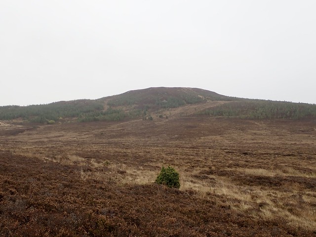
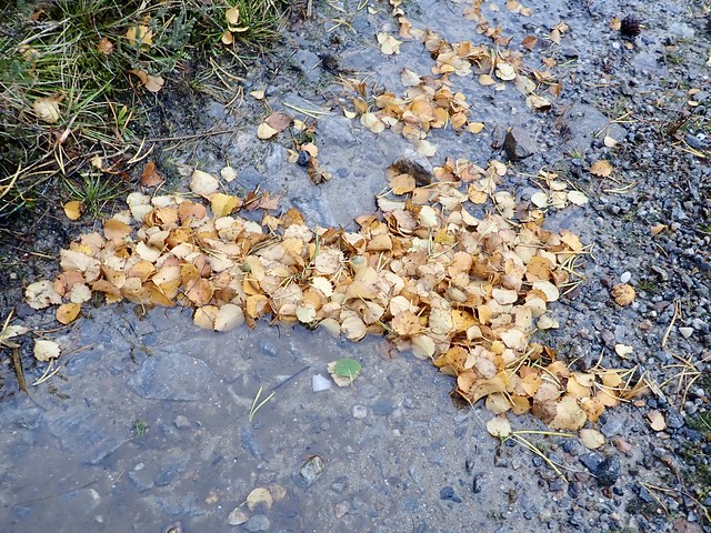
Allison had Thursday off, so we set off early on Thursday morning and drove up the side of Loch Ness, arriving at Drumnadrochit for our first hill - Meall na h-Eilrig - the rounded hill of the (deer) corral. There's a wee road just east of Drumnadrochit that rises steeply uphill to end at Wester Achtuie farm - good parking available. As we were getting out the car we both noticed a pungent smell - Allison suggested "deer stink" though it seemed different from usual. It stayed with us as we walked along the sodden farm track towards the forestry enclosure and persisted as we picked our way through young trees and tussocks to reach the summit where we had lunch. We walked back the same way. Not a very spectacular hill.
 D8C676CE-96EB-47C4-8B21-E0042944B02B_1_201_a
 by
Al, on Flickr
Meall na h-Eilrig
 40B66B4D-D6DB-411A-9A7D-7D3664217C4D_1_201_a
 by
Al, on Flickr
 EB706F84-3593-44B4-827A-832A78D9D596_1_201_a
 by
Al, on Flickr
 0C70C25F-CF37-4F44-B57C-14AA35806AE0
 by
Al, on Flickr
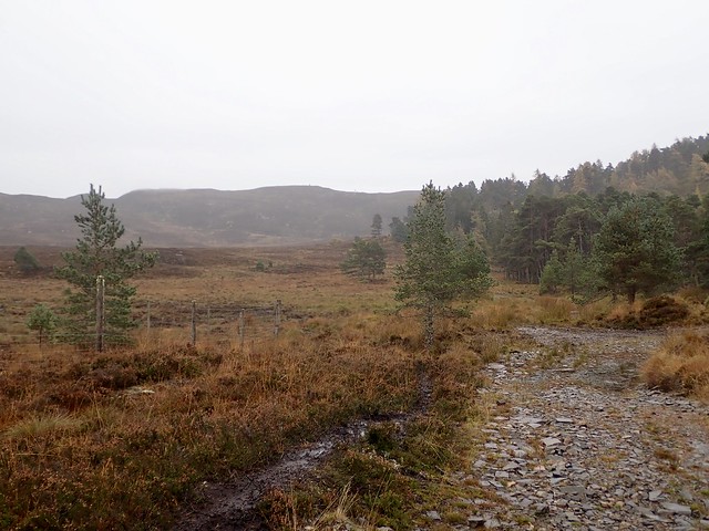
The next one, Carn a'Bhodaich, was reached by returning to the A82 and driving round the road a bit til the sharp turn left for Abrichan, and continuing as far as Ladycairn. The hill can also be done from Abrichan and Achpopuli but I chose Ladycairn as it was on track, at least theoretically. Good parking again by the houses and a forestry track that starts off promisingly but quickly becomes a quaggy mire. Or maybe that's just in these days of flood. We stayed on the track probably too long then cut up through heather tussocks to reach the gloriously yellow lichen encrusted trig column. Sort-cutted a little coming off the hill.
Good track...at the beginning
 546FAD48-93FF-4D43-BF7E-52C121D0C8A5_1_201_a
 by
Al, on Flickr
Hmmmm
 745DBB9D-98C1-4065-9B98-DF7AEB177B74_1_201_a
 by
Al, on Flickr
Carn a'Bhodaich
 8E41ABBA-DFF1-4B46-886F-3318F84F5E53_1_201_a
 by
Al, on Flickr
 77B45654-4E71-47DD-8210-0F8F3B031919_1_201_a
 by
Al, on Flickr
 2A471B90-858C-428E-B534-D9C3D3C8FACE
 by
Al, on Flickr
Now it was time to head to Cannaich - haven't been there for a while and we always seem to visit at the wintry time of year. We pitched in our usual place, down amongst the pines. Matt usually comes and sees us in the evening to collect his money, but no-one came our way. It rained a bit overnight but wasn't too wild. The forecast for Friday was the most promising, mostly dry with snow showers, and winds just in the 30mph range. Saturday and Sunday were to be much, much worse. I didn't have enough Subs to do in the Cannaich area for three days, so thought we might as well do some Munros - I needed the eastern three Strathfarrar hills for my third round, whilst Allison needed all four. I didn't think we had any chance of doing the four at this time of year with our present level of unfitness, so the three would suffice. Not that I was biased

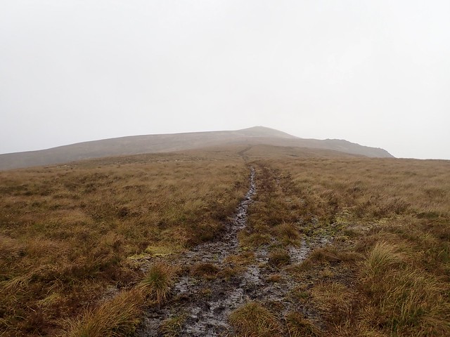
Friday morning was quite nice - we rose too early and had almost half an hour to wait til the Gate opened. I remembered I'd left my waterproof jacket in the tent when we got to the gate - fortunately I had a lightweight one in the car which should suffice for today. The gate keeper lady was rejoicing that she only had one more day to work before the winter status comes in and she can disappear for half the year - heading off to Luskentyre Beach she said. Anyway, we were through, behind a couple of guys going canoeing. We parked up after Deanie Power Station and set off for the long haul up Sgurr na Ruaidhe. Pretty autumnal colours between the heathers and the trees. No "deer stink" today, thankfully. I had a wary eye on the Allt Coire Mhullidh, knowing we'd have to cross this somewhere on our return leg from Sgurr a'Choire Ghlais - it looked quite fast flowing. The track was sodden and slippy in the ATV churned peat - we spotted another walker in shorts (really) who had taken a higher line and overtaken us. Crossing the Allt Freumhach was alright, but as we gained height the rain/bits of hail started. Mr Shorts had donned waterproofs by that time, I was glad to see.
 7CD482C7-3933-4E14-9ED4-21D25FA0CE87_1_201_a
 by
Al, on Flickr
 13BF5CAA-994B-4EA1-B6C5-100CFE6476C8_1_201_a
 by
Al, on Flickr
Bit of a sludge fest
 563CFFFA-ED50-47C5-B26C-107E067B5C81_1_201_a
 by
Al, on Flickr
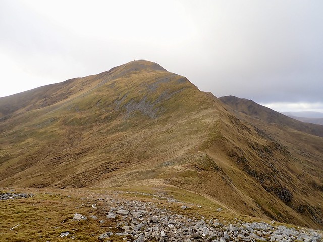
There's quite a difference going up Munros when you are used to doing Subs - I looked at my GPS and saw another 600m elevation required to get to the first summit. 600 metres! But it is steady going at least. The wind was quite strong as we reached the summit cairn, but the day was starting to clear and the two hills ahead of us were now coming out of the clag. We found a rare bit of shelter in Bealach nam Botaichean for a lunch stop, then comtinued up Carn nan Gobhar. Summit boulderfields are not much fun in high winds. Then onwards to Sgurr a'Choire Ghlais, with memories of last time we were up here in poor viz and snow, worrying about stepping off the edge of cornice and being relieved to find some old footprints to follow. Anyway, there was no snow today, just a burst of hail when we were near the summit. Mr Shorts was obviously going for the four - though he wasn't travelling that much quicker than we were and I did wonder if he'd make it back in time. I suggested to Allison she could go over and do the fourth whilst I returned to the car then drove up to the west end of the glen to pick her up, reducing the required distance by almost 5 miles, but she didn't fancy going over on her own, fair do.
Summit Ruaidhe
 54CF7C52-CF32-461E-A79B-F85F494B83E0_1_201_a
 by
Al, on Flickr
The way ahead
 AE2D1856-BF8B-4738-AE3B-496B75B24BC6_1_201_a
 by
Al, on Flickr
Ghlais from Gobhar
 E90C7183-5F2C-4BED-81C9-67D35F9E2B96_1_201_a
 by
Al, on Flickr
Summit Ghlais
 4CDA63D2-E930-47A6-BBC4-8BCF08C3F441_1_201_a
 by
Al, on Flickr
We came off the southern shoulder of Ghlais, as we'd done last time when bagging the Sim of Meall a'Gheur Fheadain - we cut down into Coire Mhuillidh higher up so that we could cross the Allt before it had been re-inforced by too many tributaries. Found an OK place to cross, followed the riverbank for a bit on deer tracks but tiring of this, headed back to the ATV track we'd come up on and returned to the car.
Weather coming in from the west
 B842E6EA-21A5-4972-9A27-44C9B5E3B874_1_201_a
 by
Al, on Flickr
 859ED9BA-62FB-4122-A067-938CF527FF74_1_201_a
 by
Al, on Flickr
 4B30ACD5-7957-49C9-929D-A071E1878C98
 by
Al, on Flickr
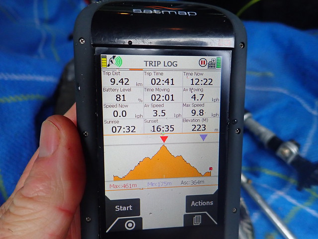
A wetter, wilder night, pine needles from the surrounding trees littering the outside of the tent, leaving it looking like it was growing a Desperate Dan beard. We timed our arrival at The Gate with more efficiency today- the Gate Lady saying she imagined we'd be blown out of the glen sooner than we'd planned. With windspeeds on the Strathfarrar Munros being mid 70mph and gusts of 86mph or more I wasn't necessarily doubting her - our two hills, at the very far end of the glen were 600m high, so not tiny Subs. The forecast was for the day to start off not too bad then for all hell to hit by 11am.
We drove along the glen, worrying a little about the possibility of fallen trees blocking our egress or the River Farrar overflowing its banks at the beginning of the glen - it had seemed much fuller than yesterday. A squadron of two dozen ducks and drakes flew past the car as we drove by Braulin Lodge, maybe a sign of things to come. I had originally planned to leave the car in the lay-by before the first dam and walk the route, but not in such conditions - instead we drove across the dams (always a bit thrilling/scary to do this, like being in a James Bond film, I think) and parked up by the sub-station, where there's room for one car if you leave space for a second vehicle to turn and get back out. Our first hill, Beinn Dubh an Iaruinn was ahead of us. As we dressed for war, the "deer stink" was back - I realised this was on my waterproof jacket...one of my lady-cat's "suitors" had obviously decided to give it a liberal spray having come uninvited into the house at some point over the week. Knowing what it was didn't help, and the stench got stronger as the jacket got warmer - ie when I was struggling up the hill side.
A wild morning
 F38D086F-2D10-4C28-84B6-6A28064F3646_1_201_a
 by
Al, on Flickr
 3AB94FA0-CF28-43B3-BB31-CF9BAF7D52C4_1_201_a
 by
Al, on Flickr
First hill
 CC06C424-FCBA-47D2-9891-EB84A74B1E61_1_201_a
 by
Al, on Flickr
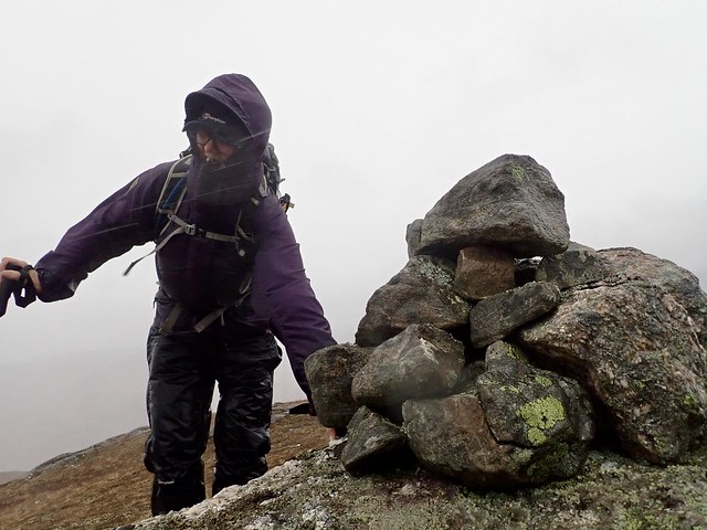
The wind was ferocious where we were exposed to it, which was mostly as we neared the first summit. We managed to contour round the leeward side then made a dash for the cairn - I had to lie on the ground to take a picture as Allison approached the cairn, otherwise I'd have been blown off my feet. We retreated to the leeward side once again and progress to Coire na Feithe wasn't too bad, other than being sodden underfoot. We picked up an ATV track for some of the way and stopped behind a knoll in the coire for lunch. Looking up at Meallan Odhar Doire nan Gillean I thought we might be a tad exposed along the top, although there were no narrow ridges to be blown off.
 333ABB76-5EB7-4A49-A22C-5A5BB74B873F_1_201_a
 by
Al, on Flickr
Struggling at summit of Iaruinn
 9E496926-DE4A-4310-829B-F098375EDAED_1_201_a
 by
Al, on Flickr
Meallan Odlar Doire nan Gillean
 CEFCD06A-BB22-4C12-A4A9-1E98A4C905CC_1_201_a
 by
Al, on Flickr
Glimpse of Loch Monar
 521EB059-4F0A-4BD1-ABF7-3EB67CAE1B98_1_201_a
 by
Al, on Flickr
Summoning up strength we set off again, taking deer tracks up the slope of Meallan Odhar. Some craggy views out towards Loch Bonar beckoned and Iremarked how nice a vantage point this would be on a good day. Wonder of wonders - as we climbed the rain went off, the sun emerged and the clag lifted, leaving us some truly gorgeous views along the loch, with the Achnashellach hills and Lurg Mhor sitting pretty. The flat summit of the Sub would make a fine high camp (in other weathers obviously) - just a pity you'd have to walk or cycle up the full length of the glen to enjoy it.
Achnashellach Hills
 BF811C86-9C05-49BB-84AD-5A4E88AB51C7_1_201_a
 by
Al, on Flickr
Lurg Mhor on the left of Loch Monar (for anyone wondering why it's called "the big ship")
 7A8E61AE-E074-4709-B633-CB9440E2D479_1_201_a
 by
Al, on Flickr
 DF8A42EA-9541-4A29-9F10-1FE3C62386CF_1_201_a
 by
Al, on Flickr
 27FCF06A-F147-4CA9-9F88-5BDE79750AE8_1_201_a
 by
Al, on Flickr
Summit of Meallan Odhar Doire nan Gillean, with Sgurr na Lapaich behind it
 8757D26E-9BD8-4284-AE68-0E29F26957D3_1_201_a
 by
Al, on Flickr
 02737AAE-2181-40D5-8742-E12F29515E70_1_201_a
 by
Al, on Flickr
Summit rock, Strathfarrar hills behind
 57015DD9-E457-4BB4-8FE5-5C42B5364475_1_201_a
 by
Al, on Flickr
This summit is a "Weasel" (ie between 600 and 610m high, a Sim and a Marilyn) - so a Weasel on a Weasel
 B319360B-BCEE-4582-BBA2-63DF6383DF76_1_201_a
 by
Al, on Flickr
 F103FD95-9C05-4450-A38D-DB6B780F374C_1_201_a
 by
Al, on Flickr
 B2ED8596-E779-4B00-9197-EAE823DA40DE_1_201_a
 by
Al, on Flickr
Sgurr na Lapaich
 1F4E4063-EDD4-480C-80F3-D82DDA687D82_1_201_a
 by
Al, on Flickr
Beinn Dubh an Iaruinn and the white waters
 0434291B-7C81-45EB-8F37-98F853F218F7_1_201_a
 by
Al, on Flickr
 A3EB2CFC-D07F-4CF2-8B47-29F1A4B3F077_1_201_a
 by
Al, on Flickr
We were heartened by the scenery and the descent seemed nothing to concern us - there was even a stalkers path to accompany us down - until, that is we saw the state of the Allt Coire nam Feithe which was looking very white indeed. We had two options - head back up into the coire and cross at an easier point or make for the two bridges where the Allt joins the bigger river running along the glen. The bridge option won. After an uncomplicated crossing we were onto proper road, passing the power station (which has more parking options than where we parked) then back along the road for a couple of kilometres to the car. By this time it was about 3pm, nice time to drive along the glen in the afternoon sun and get home before dark.
 E1177592-C4A2-49B6-870A-EDE0CFBB5E4C_1_201_a
 by
Al, on Flickr
 50757C4C-93FE-439B-ABCD-C4A053D5073F_1_201_a
 by
Al, on Flickr
Power station
 15D07E67-AF5C-4AD7-A738-4E41FDB29D82_1_201_a
 by
Al, on Flickr
 67EC5A76-5C98-4A36-939E-B89B7E2B6605
 by
Al, on Flickr
 371A3ABF-7B3E-401C-B97E-201F5CC497CC_1_201_a
 by
Al, on Flickr
We'd not long rejoined the main road along Strathfarrar when we saw an old white BMW at the side of the road. A lady rushed out to ask for assistance - she'd broken down - could we wait til she tried to fix something in her electronics - if it didn't work could we call the AA for her from the gate end of the glen? We were happy to wait - she clearly knew her way around the car's electronics, but couldn't get the vehicle to go. I suggested that I give her a tow - I had often imagined breaking down in a remote glen, although not with the added complication of a locked gate at the end of it, so I was happy to give what assistance I could. There were some problems with this however - I'd never towed anyone before and her car's tow-eye had rusted away, so she'd need to put the rope onto her front axle. So she did that and we set off. We had the best part of 12 miles of single track road to negotiate - fortunately we only met one vehicle coming the other way, as we had no option to reverse...The rope snapped once, it being difficult to keep the tension at the required amount when going up and down hills. Then there were the speed bumps and three separate lots of sheep on the road to try and get past. But we made it, got to the gate and the gate lady was quite solicitous, even though she said we were "mental" for being out on the hills on a day like today. The car lady (Claire) called the AA who duly came to fix her car after 3 hours, whilst we headed back to the tent, having the further hurdle of avoiding numerous bits of tree debris along the road from Struy to Cannaich. There were a couple of bigger trees that had fallen on the road and been sawed - I guess if you live up here you keep a chainsaw in your boot in windy weather.
We were warmed by a hot shower then a spicy red lentil curry at the campsite before turning in for an early night - quite enough excitement for one day. The forecast for Sunday was more of the same regarding the winds and heavy snow on the hills, rain at lower levels. I had left on easy hill, Carn nam Bad for today - a mostly track affair from just east of Cannaich. We packed up, rid the tent of its "beard" and drove a few miles to the beginning of the track at Mellness Forest, just across the road from the "Dark Deer Farm" which sounds decidedly satanic if you ask me...anyway there's no parking at the start of the track so we left the car in a larger track opening about 500m west.
Over a stile then through some woods, passing a small boat, as you do. Good forestry track underfoot, the rain abating and some sunshine coming out. The squat form of Carn nam Bad appeared over the serried ranks of pines and the Beauty-Denny Power Line. We left the track as we neared Loch Carn nam Badan and deer tracks did the rest til we reached the summit cairn. We returned to the track and a mix of sun and showers accompanied us back to the car.
 EB42CB89-1007-45DB-AC28-9B269C3DB968_1_201_a
 by
Al, on Flickr
I've heard the term "a sea of trees..."
 80B96B72-8976-4CFD-AB4F-B6A376975645_1_201_a
 by
Al, on Flickr
 5F3FFEB9-C4DE-4604-AA02-F1BDBA8682C6_1_201_a
 by
Al, on Flickr
Carn nam Bad
 7C915F61-2914-4497-B6BC-22EC3CD61D26_1_201_a
 by
Al, on Flickr
 F2C1A7A9-1AEB-4BF9-B40B-4535DC487D11_1_201_a
 by
Al, on Flickr
 F3466980-900D-485D-87C8-FA7E74AA2678_1_201_a
 by
Al, on Flickr
One of our weirder lunch choices...
 0094AD98-76FC-45F3-9E65-6EEFFE93B7C5_1_201_a
 by
Al, on Flickr
 7E8354A1-23FE-478B-8B87-D72D779E71BF
 by
Al, on Flickr
.
