free to be able to rate and comment on reports (as well as access 1:25000 mapping).
 Lingeigh Beach, North Uist
 by
Anne C, on Flickr
The Outer Hebrides are a place apart and of all the very different islands that make up that wonderful 130 mile chain, none has touched my heart more than North Uist. My grandmother came from there and her own mother from the remote Monach Isles, so perhaps genetic memory is also at work.There is something about the flat machair lands, wildflower strewn behind the dazzling shell sands; the heather moorland speckled with countless lochans and indented with endless bays, the low shapely hills that rise from a bed of some of the world’s oldest rock, the highest barely a 1,000 feet. I can’t get enough of it all and in all weathers. It must be in my blood.
I've covered 3 walks in this report -
Beinn Scolpaig, Vallay Tidal Island and Beinn Shleibh on Berneray.North Uist and Harris were where we made a beeline for, once the travel restrictions of lockdown ended in July and visitors were allowed on Calmac ferries again.
It seemed almost unreal to be sitting in the ferry queue at Uig, waiting to board.

It’s a beautiful sail too - we watched dolphins on the hunt at one point though I only got a couple of blurry shots of which this is one...
 Dolphins from the ferry
 by
Anne C, on Flickr
Then out past the Ascrib Islands, some puffins floating peacefully, then fluttering off as we passed, little legs splayed behind them.
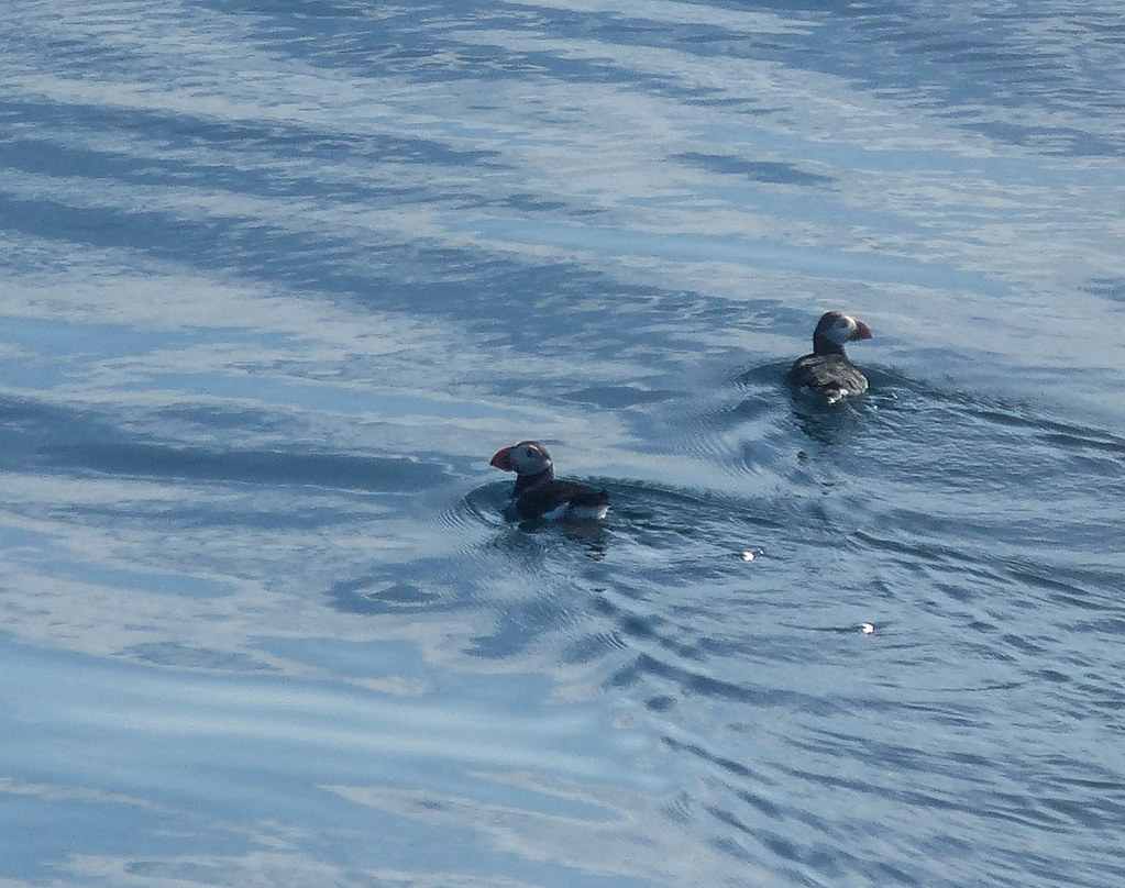 P1030823.jpg
 by
Anne C, on Flickr
There were some Great Skuas patrolling, on the look out to steal the prey of other seabirds. Then out past Waternish Point where once we’d watched a Minke whale and calf at the end of a dramatic, unfrequented coastal walk on Skye. Dunvegan Head's great prow appeared and Neist Point's lighthouse.
 Dunvegan Head and Neist Point
 by
Anne C, on Flickr
 The Cuillin from the ferry
 by
Anne C, on Flickr
The approach to Lochmaddy is my favourite of all CalMac journeys. I’m on deck for most of the sail but always make sure I’m on the port side as we enter the sheltered waters of Loch nam Madadh, the Loch of the Wolves ( the Wolves being two of the rocky islets which protect the bay’s entrance.)
 P1030786.jpg
 by
Anne C, on Flickr
North and South Lee and Eaval grow closer, rising out of the empty moorland. Perhaps a sea eagle sweeping across the bay, though not this time. The three hills look a little like the Paps of Jura in outline, albeit much lower, as if a great hand had pressed North Uist into the ocean, leaving only a scattering of low summits.
 North/South Lee and Eaval
 by
Anne C, on Flickr
We headed first to our B&B before 3 nights camping at Lingeigh beach. Normally we do it the other way round, as the B&B is for a bit of a scrub up but it was down to availability this time. A 25 min drive off the ferry and we were at Effie’s house, a Gaelic speaking lady we have stayed with before and whose immaculate home is near Balranald RSPB reserve in a lovely part of North Uist. We had a nice wee apartment all to ourselves. After a socially distanced chat over a cup of tea with our hostess,
we headed off to get a nice walk in and enjoy the July sunshine.
Beinn Scolpaig Loop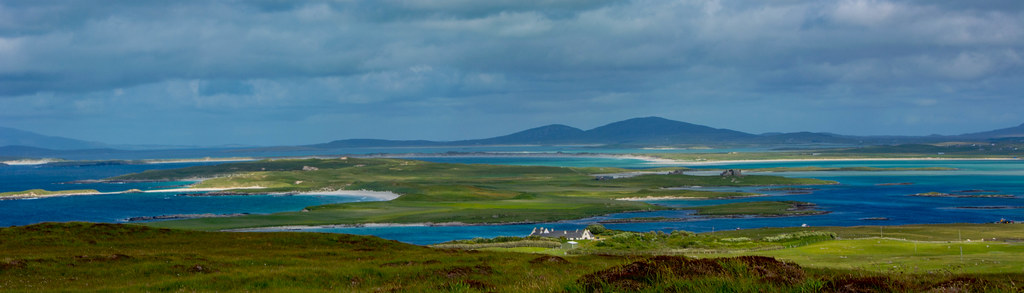 Looing over Vallay island to Bheinn Mor, North Uist
 by
Anne C, on Flickr
Just a short drive from the house, we parked off the road to explore an area I didn’t know but had always thought absolutely beautiful - Scolpaig. A few minutes walk along the road brought us to the big farm track and gate which is the start of the walk. In 5 minutes, we were down at Loch Scolpaig itself with its lovely Victorian tower built on a tiny island.
 Loch Scolpaig
 by
Anne C, on Flickr
Blue skies, larks singing their hearts out above us, a curlew calling mournfully, the air scented with clover and bog myrtle – summer in the Hebrides and to me, there is nowhere to compare. The machair is said to provide the greatest wildflower show in the UK and the Uists and Tiree, known as The Machair Islands, offer the best of that.
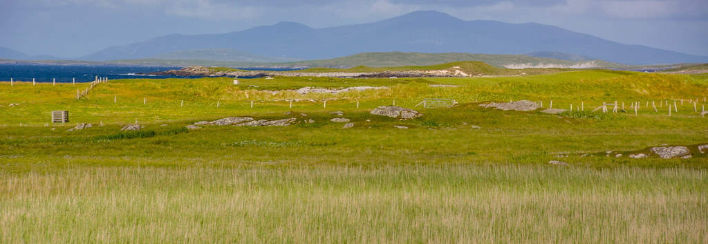
 Lingeigh
 by
Anne C, on Flickr
The track led us in no time down to the rocky coast itself where the ocean sparkled in the afternoon sunshine ( I suppose it must be the angle or direction of the sun, as the sea never seems to sparkle in the morning?

) I always know when Chris is really happy because he starts scouting around for ‘good camping pitches’ and he was now wandering about doing just that, staring at and prodding the ground.

 Scolpaig beach with Beinn Scolpaig behind
 by
Anne C, on Flickr
Scolpaig bay itself was very sheltered, with a lovely crescent of white sand and not soul around.
Above the beach rose Beinn Scolpaig itself, all 88m of it! Tiny, but I knew it was a great viewpoint as we’d climbed up to its summit from the other side some years ago and spent quite a bit of time exploring the Griminish peninsula. But first a wander along the beach before heading up onto the machair again and an easy climb up the gentle slopes of the hill itself. Part way up, there was a small memorial cairn, a simple rough stone, dedicated to a lady who ‘ had loved this place.’ I’m always caught, emotionally, by these records of previous lives lived and happiness felt and had a sudden, painful thought – 20, 30 years hence (if, as my Mother in Law says, ‘we are spared’) and this place will be as it has been for centuries and most probably we will not be here to see it. Who needs heaven when it is here all around us in this life now?
I was surprised at how much heather was in flower but it had been a very warm, sunny spring and early summer.
 Early heather, Beinn Scolpaig
 by
Anne C, on Flickr
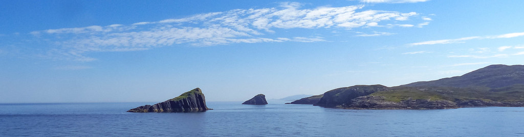
Out west lay the rocky notched outline of the islands of Heisker Eagach.Heisker is an old Norse word – ‘sker’ meaning rock sticking out of the sea. The Outer Isles still have a mix of Gaelic and Old Norse names/words, given their Viking heritage.
 Heisker Eagach
 by
Anne C, on Flickr
In no time, we were up on the wide flat summit, sprinkled with bog cotton fluttering in the breeze.
 Harris to the north beyond N.Uist
 by
Anne C, on Flickr
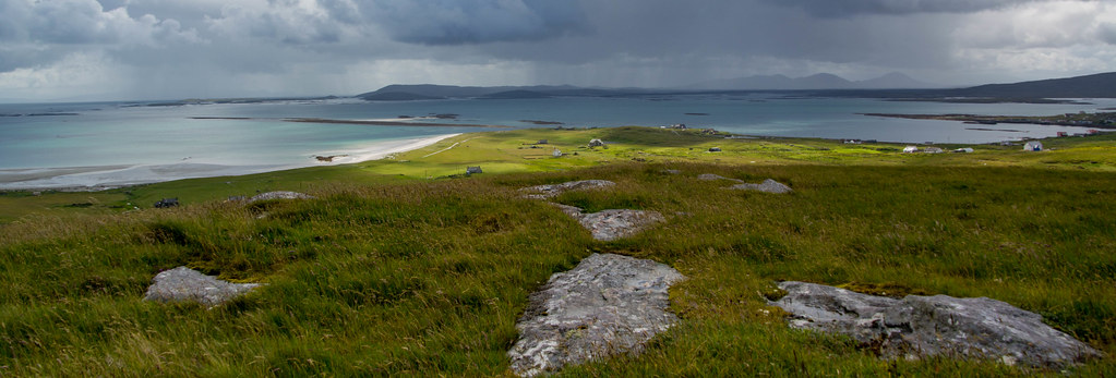
A fine panorama opened up across Vallay tidal island (tomorrow's walk), all the way to the hills of Harris, looking very blue, interspersed with the dazzling white beaches at Malaclete and Grenitote.
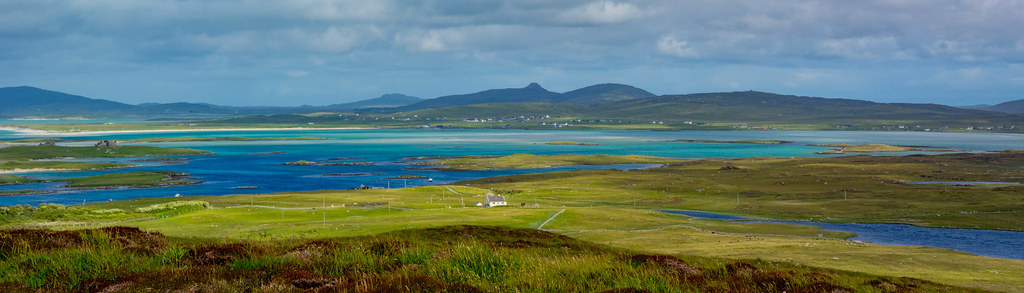 From Beinn Scolpaig
 by
Anne C, on Flickr
 Untitled
 by
Anne C, on Flickr
On the horizon, 40 miles away, St Kilda and Boreray were visible though I didn't get a good shot of them.
We made our way down easy moorland slopes, my eye on an emerald sward behind a beach and a lovely turquoise bay.
 Beach upon beach...
 by
Anne C, on Flickr
 Untitled
 by
Anne C, on Flickr
Quite a large herd of Highland Cattle watched our progress too and our way was soon blocked by them. They seemed to have particularly enormous horns!

I know they are gentle beasts but many had calves and my father always warned me that a cow with a calf was much more dangerous than a bull. Like all cattle they were very curious, staring up at us as we approached; one or two moved towards us, no doubt thinking we were the farmer coming to give them extra feed. It did make them a bit intimidating! Even Chris decided that rather than brazen our way through waving our poles if needs be, we’d be best detouring which I agreed with immediately.
 Untitled
 by
Anne C, on Flickr
Finally we outflanked them, heading across the grass and down to the beach, where some comfy flat rocks made a good seat, to enjoy what was a really idyllic spot.
After having some tea and my current addiction, a KitKat (nothing like living dangerously
) we forced ourselves to get on the move again, making for a gate. However, several cows and calves were milling around it, blocking our exit route. So nothing for it but a careful leg swing over a barbed wire fence, to pick up a good track again. This took us past the pretty thatched cottage at Griminish which featured in Monty Hall’s TV series The Great Hebridean Escape. It’s now a holiday house and as they say ‘nae cheap!’

 Monty Halls' Cottage at Griminish
 by
Anne C, on Flickr
 Roineval, Harris
 by
Anne C, on Flickr
Then up past Loch an Eilean and Loch Olabhat, set amidst beautiful soft landscapes where a herd of handsome little shaggy brown Hebridean (or is it Soay?) sheep were grazing.
 Soay or Hebridean sheep
 by
Anne C, on Flickr
 Looking to Beinn Scolpaig from Loch Olabhat
 by
Anne C, on Flickr
In 10 mins , we were back up on the main road again with a mile or so to walk back to the car. It’s a very quiet single track road at the best of times so no problem with traffic as such, but tarmac always feels a lot harder on the feet and legs.
We passed a huge boulder and plaque dedicated to Donald Mor Maclellan. He certainly must have been ‘Mor’ to have lifted it to arm's length in 1876.
 Donald Mor Maclellan's Stone
 by
Anne C, on Flickr
Back to the car in 20 mins or so and we just had time to drive down to Grimsay to catch the Kallin Shellfish Shop before it closed. I can’t recommend it highly enough for anyone who like all things fishy. We bought a favourite combination for dinner at the house - cocktail crab claws, langoustines and hot smoked salmon.
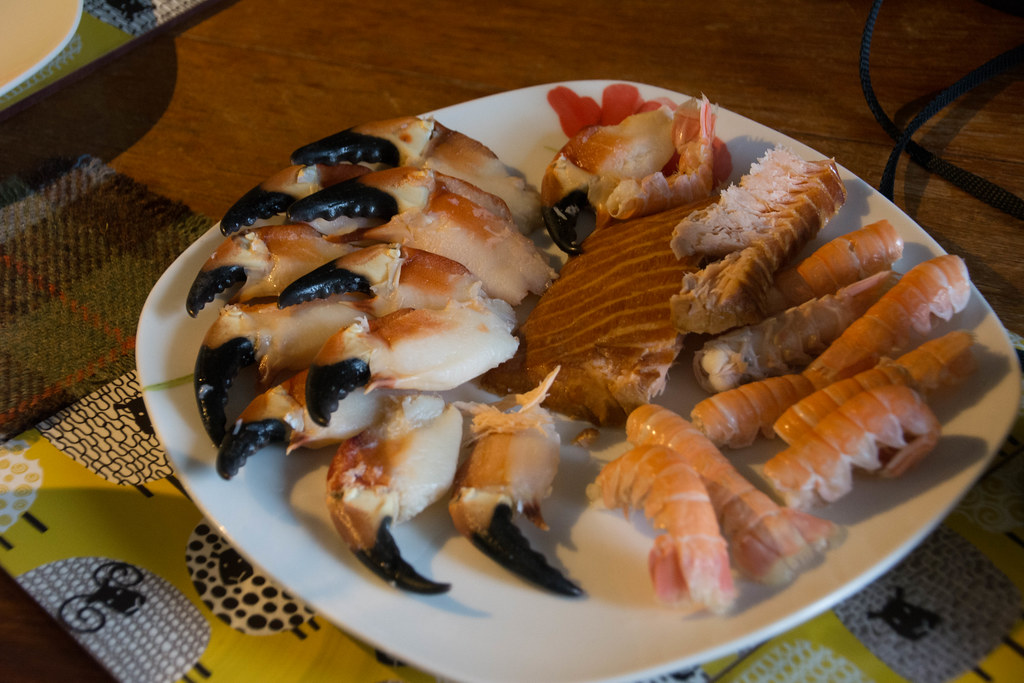 Dinner! c/o Kallin Shellfish, Grimsay
 by
Anne C, on Flickr
Back at Effie’s, we popped open a bottle of Lidl’s Champagne to toast to being back once again in this magical part of the world and - amazingly – with the forecast set pretty good for the next 5 days ahead.
Vallay Tidal Island DSC_0287.jpg
 by
Anne C, on Flickr
Vallay sits off the north coast of North Uist, opposite Malaclete and when the tide is in, the water is aquamarine and quite stunning. At low tide, there a 2.5km crossing of the tidal sands required to reach the island, so it’s vital to check the tide tables to work out when its safest to cross and have enough time to explore. We arrived at 10am, a couple of hours before low tide at 12noon. That gave us around 4 hours on the island before we had to beat a safe retreat back to the mainland.
We weren’t the only folk at the rough parking area at Cladach Bhalaigh opposite one of North Uist’s few forestry plantations, with several cars already parked there. Vallay was busy (well, if 4 other people count as busy. That sometimes seems the case on North Uist’s vast beaches!)
It was a lovely morning, sunny and warm but with some big clouds out west too. There are a couple of places early on in the crossing where some wading is required, even at lowest tide so we decided to take the boots off and just walk in bare feet all the way. The sand is so soft and smooth, it was a pleasure.
 Near low tide, Vallay island on the left
 by
Anne C, on Flickr
I’d downloaded the map showing the safe route across but vehicle tracks are also visible as a guide (presumably used so often over so many decades that even the tide doesn’t quite obliterate them.) Off we set, and immediately I loved the squelch of the cool sand on my feet and the chance to splash across some clear inlets of sea water which were up to mid-calf. It was lovely going and there’s something really special about knowing you are out on sands usually covered by the sea, given a little window to reach somewhere remote and often inaccessible. It makes it feel ultra special.
 DSC_0324.jpg
 by
Anne C, on Flickr
In half an hour we were across, sitting on a rock drying our feet off and getting the walking boots back on. Behind us lay the huge, sad ruins of Vallay House, a grand Baronial style mansion which had been the home of Erskine Beveridge, an archaeologist and naturalist who’d fallen in love with the area and who built the imposing pile in 1902.I was conscious that we had a set time on Vallay and suggested to Chris that we head for the west coast beaches first and spend any time we had left after that, having a wee look around the house’s exterior. There was something slightly spooky about it with its huge windows without glass, like sightless eyes, the gardens choked with thistles and nettles grown hip high.

The dry stane dyke walls which lined the property were still beautiful though - I often wish more farms had these instead of the ugly barbed wire fencing which predominates though no doubt that’s much cheaper and easier to repair. When I was in the west of Ireland last year there were signs posted by locals stating ‘no wire fences here!’ in big lettering. They seem to have done a great job of retaining these lovely structures which enhance rather than detract from the countryside.
I was punished for these negative thoughts at this point, as an ominous black cloud suddenly blocked out the sun, followed quickly by the pitter patter of rain and in seconds, a deluge! It was torrential!
On with the waterproofs pronto and a brief shelter against the house’s walls, to avoid the worst. But it was minor punishment and it passed in minutes thankfully.
The way to the west coast was now down an initially very boggy track – seriously churned up by cattle to the point of requiring a minor detour. The path was good beyond this however and in 5 mins we were approaching the dunes. That is certainly one of the pleasures of coastal walking (and camping) in the Outer Isles – there’s usually plenty of dry ground. Made our way through a wee break in the marram grass and found ourselves standing on a glorious beach, a scalloped bay of shell sand called Cuil na Muice, or Back of the Whale. What a place!
 Back of the Whale beach
 by
Anne C, on Flickr
I am a bit of a beach fiend and love just wandering along, looking for shells and anything else interesting, admiring the changing colours of sea and sky and listening to the crash of the surf. After a stroll to the far end, we found a seat on some rocks, got the flask out and made some tea. Then just sat and listened to the oystercatchers piping and ringed plovers feeding, scurrying back and forward as the waves surged in and out. There was a breath of wind, enough to keep midges away and the sun had re-appeared. All was well with the world.
 DSC_0283.jpg
 by
Anne C, on Flickr
I was keen to see the remains of an ancient temple which lay out on the grassy spit of land called Orasay (which means tidal island) so we eventually headed out to check the site. Just a scattering of stones marked the spot in this wild place, close to the pounding waves of the cold Atlantic. Incredible to think of monks living out here though for isolation and solitude, this was certainly the place.
For some reason Chris decided to head back to the beach via a rocky shore , waving me to follow him as a ‘shortcut’ back to the sand, but there was no way I was clambering over seaweed and really jagged slabs, when there was nice soft grass to walk on. I watched from above as he scuttled his way along, before he suddenly slipped on the greasy surface of one slab, crashing down hard on his bare knee.
A bit of a shock to see as he came down really hard and got a nasty gash, but he was soon up and hobbling along again. It was after 12 by now, so a decent time to get the sandwiches out and have some lunch. I think it’s very true – sea air does make you extra hungry!
 DSC_0294.jpg
 by
Anne C, on Flickr
I could have pottered about that beach for a long time but it was time to carry on along the coast. Had a peek at neighbouring Traigh Himiligh , a beach which also looked lovely, then we headed south to Bagh na Craobhag or Bay of the little Trees. No trees now unfortunately, very few in Uist. This was nice too though not as spectacular as where we had been. Then on to a stonier beach at Camus na Criche or the Bay of the Boundary. This was a smellier sea-weedy beach much populated by wading birds and also a handsome red throated diver offshore, dark red throat very clear against its handsome pale grey plumage.
Heading inland across the machair, we made for a Memorial cairn which was erected in memory of Beveridge’s son George who drowned while sailing across the strand in 1944.
 Memorial to George Beveridge
 by
Anne C, on Flickr
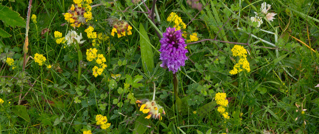 Marsh orchid amongst the machair flowers
 by
Anne C, on Flickr
Some good views to Boreray (beside St Kilda) too...
 Boreray from Vallay
 by
Anne C, on Flickr
A nice track now took us back to the ruins of Vallay House but our four hours - somehow
- was almost up and we thought it better to get the boots off again and begin our trek across the sands back to North Uist and the car.
 DSC_0327.jpg
 by
Anne C, on Flickr
Onto the sands again and halfway across, we made a brief detour to Torogaigh island, one of two small islets exposed at low tide, just for the sake of having set foot on it! I noticed later that it doesn’t count as a Walkhighlands island.
By 2pm we were back at the car, drying off our feet and also seeing the 4 people we’d said hello to earlier.
Time to pick up supplies for tonight’s dinner so stopped at the Co-op in Sollas and picked up Chicken Pakora (not the healthiest, but so good) and sausages to heat on the small portable BBQ. We were back to camping now for the next few nights and had the tent to pitch at Lingeigh beach.
 Lingeigh
 by
Anne C, on Flickr
It’s a lovely drive to Lingeigh and we soon got sorted at our favourite spot, various bits of gear arranged with plenty time to have a wander on the beach itself. It’s an absolute beauty, one of my favourites in all the Hebrides and a fine spot to watch a sunset too. Just over the other side of the spit of land lies Lingeigh's twin - Hornish beach.
 Hornish Beach
 by
Anne C, on Flickr
 Hornish Beach
 by
Anne C, on Flickr
The previous summer in 2019, we were here too and chatted to a couple of young women from Germany, for whom it was their first visit. They were seeing it all under sunny skies and it was looking stunningly beautiful. One of the pair seemed to be in a sort of trance, just gazing around, rather than being involved as her friend was in our conversation. She wandered off eventually (great conversationalists that we are) and her friend said that they’d just come from Harris. I was taken aback when she said that it was stunning but too ‘commercialised.’ Eh?? It’s hardly that even if a little busier than here.
Having gone off this girl a wee bit she then redeemed herself when she looked all around – ‘we’ve never seen anywhere like this. We want to move here!’ Well, I can sympathise because I’ve often had the same thoughts myself. A nice feeling to know that someone else had fallen in love with North Uist.
A lovely quiet evening at the tent, well fed, a glass of wine or two and finally, a soft pastel sunset over the hills of Harris. In the words of Phil Collins…another day in paradise.
 Sunset from the tent
 by
Anne C, on Flickr
A Loop around Bernernay Harris from Beinn Shleibh, Berneray
 by
Anne C, on Flickr
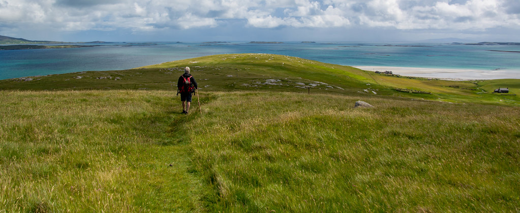
Mugs of tea at the tent for breakfast then we were off for the short drive to Berneray, a wee gem of an island and which has one of my favourite coastal walks, an 11km or so circuit taking in its magnificent west coast beach and Beinn Shleibh, the island’s highest point at less than 100m.But – what a viewpoint!
We took a left turn at Borve and drove over to the small community hall where there is public parking. We were now right on the machair with a 5 min walk along a grassy track, taking us up through the big dunes and down onto dazzling white sands.
 Heading for the west coast beach, Berneray
 by
Anne C, on Flickr
These are a match for Lingeigh and seem to go on forever...
 DSC_0406.jpg
 by
Anne C, on Flickr
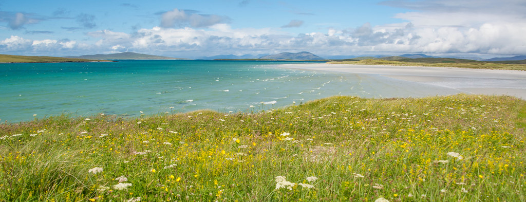
Pabbay lies offshore, a lovely green island which I really want to get out to. Apparently it has a herd of red deer and is used for the summer grazing of sheep though there was once a community there too. Rounding the corner of the sands, we had a better view of Ceapabhal on Harris and the North Harris mountains.
 Berneray's west coast beach
 by
Anne C, on Flickr
It’s just the most stunning place. I made a beeline for an outcrop of pink and black rocks which gave some nice places to sit and have the ever-required tea.
 Towards South Harris
 by
Anne C, on Flickr
 Back on the beach section of the Beinn Shleibh loop
 by
Anne C, on Flickr
 Berneray towards Ceapabhal, Harris
 by
Anne C, on Flickr
There’s a break in the dunes here which is an obvious point to head inland again, across the grass and following a series of posts which take you over the driest ground up Beinn Shleibh.
 Heading up Beinn Shleibh
 by
Anne C, on Flickr
 Beinn Shleibh
 by
Anne C, on Flickr
I made the mistake once of just heading straight uphill as the slopes are very easy but it was an absolute bog fest and earned me a few ‘I told you it would be horrible’ mumbles from Chris for not having the patience to go the slightly longer official route.

Up we headed on grassy ground on a decent path and in 10 minutes or so , we were at the Trig Point. Oh the view!
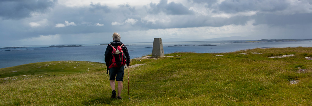 Approaching the Trig Point
 by
Anne C, on Flickr
 Pabbay
 by
Anne C, on Flickr
 Towards North/South Lee and Eaval
 by
Anne C, on Flickr
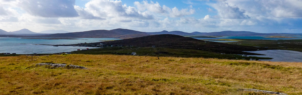 North and South Uist
 by
Anne C, on Flickr
It's a gorgeous summit. The first time we were up here Chris started scouting around for a good pitch and we promised ourselves we’d do a camp up here sometime; watching the sunset over the myriad islands and the mountains of Harris must be magnificent. Mind you, the number of places we’ve vowed to come back to with the tent are stacking up like billy -o! So much to do, so little time…
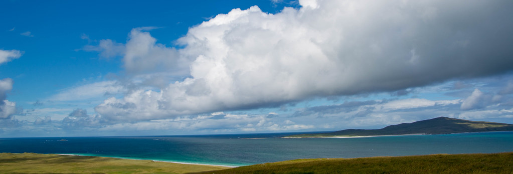
Lunch at the top and we spent ages just sitting on a flat rock admiring it all.The glacial green/turquoise of the shallow Sound of Harris was mesmerising, with the dark blue mountains of Harris beyond. To the west we could just – just- make out the familiar outline of St Kilda.
North Uist’s low hills and white sand beaches were in rain shadow to the south. Skye’s impressive headlands and the unmistakable shape of the Cuillin ridge, reared out of the Sea of the Hebrides to the east.
 Walking up Beinn Shleibh, Berneray.
 by
Anne C, on Flickr
The wind had got up though and it got very cold after half an hour or so of just sitting so time to get going again.There’s a clear path which winds down from the summit easily and carries on to the very end of the hill’s long shoulder and to a point known as Beinn Ghainche. The Sound of Harris, islet filled, lay ahead.Chris always says this is his favourite stretch of water in Scotland.
 Heading for Beinn Gainche
 by
Anne C, on Flickr
The official signposted route goes down via the old graveyard (so covered in yellow lichen it seems to blend into the landscape) but I thought it was quite a boggy route.
 Up by the old graveyard
 by
Anne C, on Flickr
It seemed less soggy to carry on east and down nice grassy slopes grazed by sheep. The views were just glorious as we headed down, with the deserted islands of Killegray and Ensay looking well worth a visit sometime (if that’s ever possible without a yacht) and in 15 mins, we had dropped down onto the end of Berneray’s east beach, past some old ruined crofts. This is a more sea-weedy beach but still lovely once you get away from one bit that has quite a bit of rotting weed on it and beyond a few houses.The tide was well out so we walked along the sands, curlews feeding, eiders offshore and fine views to North and South Lee.
 Untitled
 by
Anne C, on Flickr
 Berneray's east beach
 by
Anne C, on Flickr
After around 1km of beach walking, we came to the Gatliff Trust hostel, a converted Blackhouse with thick whitewashed walls and a thatched roof, in a fine position sitting right above the shore. It’s always left open and anyone can book it, so we took a look inside. It was very attractively but simply fitted out with a big, well kitted out kitchen, a common room and small bedrooms with bunkbeds.
 The Youth Hostel
 by
Anne C, on Flickr
A bit of road walking now for another 1km or so, on the very quiet single track which runs through the main village.
Big Atlantic Grey seals were curled up on the rocks offshore, Berneray seems to be a favourite spot for them.
 Untitled
 by
Anne C, on Flickr
Then we followed a track up past the old schoolhouse and church to a water tank area which took us onto Cnoc Bhuirgh (85m) before making our way down the easy if dampish slopes to the grassy track which led to the car.
 Back to the car
 by
Anne C, on Flickr
A joy of a walk on a bright, mostly sunny day and one I will never tire of. We had one last walk to do on North Uist - Beinn Mhor and Mheinn Bhreac - before we headed for 3 days on Harris tomorrow and a camp for a few nights at Luskentyre before one night in a new and very posh Yurt opposite Scalpay. I was keen to do a Harris hill which I’d always thought must give an incredible view – Huiseabhal Mor and it did certainly did this and more.
