free to be able to rate and comment on reports (as well as access 1:25000 mapping).
I'm finally catching up with a couple of trips to the Watershed from last year
10th August 2020Here we are again, déjà vu, ground hog day TUSSOCKS the bane of any watershedders life but particularly here in the Borders. The Borders? Why am I back there? My last outing to the Watershed finished at Achnasheen way back B.C. and even further back than that lost in the myriad of events that stopped me setting foot on it after I left in high spirits on 01/05/19 (
https://www.walkhighlands.co.uk/Forum/viewtopic.php?f=25&t=89396). This, however, does not explain why I am back, on the Watershed in the Borders.
Like many others Covid saw the end of my walking plans for 2020 Finally with strict lockdown lifted the weather was never good enough to meet my exacting standards until I resigned myself just to go for it come what may in the 2nd week of August…just as Aberdeen (through which I would have to travel by public transport) was placed back in local lockdown restrictions with Aberdeen footballers and some pubs coming under heavy fire for their behaviour. Travel to and through Aberdeen was restricted to essential travel only and I did not feel I could justify my trip with so many others having to make much bigger sacrifices. With my northern route blocked, and the southern one so time consuming, I had a light bulb moment. What about doing the small section of the Watershed that previous Scottish Shedders had left out. I have to admit back at the start (in 2017!) I went with what was the norm in previous well documented reports and started my Watershed journey at Peel Fell relying on those wiser ‘Shedders knowledge without checking. Dave Edgar, who is walking the whole of the UK Watershed wrote in his blog in 2019 of this little extension. The Watershed passes into England at Peel Fell then almost immediately turns back to follow the Border west to Deadwater then into Scotland proper to Thorlieshope Heights and onto the Larriston Fells before finally departing for good through Hobbs Flow, a total of 8-9 miles. I had decided to do it when I had finished the rest. Now was the time though just as the limited bus service from Hawick to Newcastleton was starting up again. This would put me just over 7 miles walking from the place on the border where the Watershed crosses permanently into England. The route from there would take me over the Larriston Fells and down to just north of Deadwater, then, following close to the border up to Peel Fell. Rather than walking back I could then walk on and catch a bus (one per day in the middle of the afternoon) at Carter Bar. I would need 2 overnight camps as I reckoned that I wouldn’t make the bus on my 2nd day out. I also had no idea of my hill fitness. This would be a good test.
My travel down from just south of Stonehaven went well on near empty buses. I stayed overnight with my daughter in Edinburgh then caught the 09.00 a.m. X95 bus to Hawick (change buses at Gala). The little bus to Newcastleton was on its first trip since lockdown. The few passengers knew each other and there was a jolly atmosphere as we burled along.
In my head (as I was in company and no-one wants to hear me singing)
"Every day I get in the queue (Too much, Magic Bus)
To get on the bus that takes me to you (Too much, Magic Bus"Near a pig farm we came across a tiny piglet wandering about the road. One of the other passengers managed to catch it and put it in a field, hopefully the right one. Only in the country,
I set off in hot, humid sunshine at 13.10. I was conscious that there had been road signs warning of heavy rain but wasn’t unduly worried. MWIS had talked of slow moving, heavy, possibly thundery downpours but that would be later at night and I figured I could find a spot to camp well down from high ground.
"The heat is on,the heat is on, the heat is on,
Oh it's on the street, the heat is on"I took the road to Dykecrofts cottage and my route through Newcastleton Forest I kept up a good pace passing a heavily laden walker who seemed to be struggling slightly but appeared to be carrying all his worldly possessions including 2 pairs of boots and a camping seat. He had an enormous square pack on his back out of which poked various items including a seat. and reminded me of a pedlar in days of yore. We exchanged brief information he was disappointed that there was nowhere to stay (not having checked in advance) and was looking for some where to camp in the forest. He didn’t have far to go. He appeared to have no idea of where the places were that I mentioned but equally he spoke of places south of the Border that meant nothing to me. I left him struggling along behind me and a mile further on I exchanged pleasantries and weather talk with a local resident at Dykecroft Cottages who didn’t think that the thundery weather off to the south would pose any problems. I then left the road and followed good foresty tracks up past Tweedenhead.
"Thunder on the mountain, and there's fires on the moon
A ruckus in the alley and the sun will be here soon
Today's the day, gonna grab my trombone and blow
Well, there's hot stuff here and it's everywhere I go" DSC_3236 Back to the Borders, Newcastlton Forest
 by
Seal54, on Flickr
I had views to the Lakeland fells and also recognised Greatmoor Fell and Maiden Paps to the North. I didn’t linger, thinking I would spend more time taking in the views once I was higher. Neither did I stop for photos of the many peacock butterflies although I did linger trying to follow a large bluish dragonfly. I hadn’t seen one like it before and I wanted a photo to help with ID. I failed in that but I think it was a male (pale blue) emperor dragonfly given its size.
I made good progress but was thrown by a radio mast appearing in the wrong place far too soon. I thought I had made an error amongst the many twists and turns a junctions on the track but after checking and rechecking I decided that it was a new mast (so new it doesn’t appear on the WH 1:250000) shortly after the right mast appeared ahead in the right place and distance. This was reassuring.
 Heading up towards the mast, just visible on the skyline
 by
Seal54, on Flickr
7 miles from Newcastleton and just past Flight Moss (perhaps I should have taken flight at this point) the track which had aided good progress stopped and the tussocks started. Maybe my absence from the Borders Watershed have dimmed painful memories but these were tussocks with bells and whistles which worsened when I reached the limit of the planation. Amongst the drier spots long, leggy heather tripped and tumbled me. I tried jumping from tussock to tussock and ended up on my back legs and arms waving ineffectually above me like an up-turned beetle. I tried walking in the dips between the tussocks but these were wet, at times too tight to walk in and I risked losing a boot.
“Oh, the feeling when you're reeling
You step lightly, thinking you're number one
Down to zero with a word, leaving for another one
Now you walk with your feet back on the ground
Down to the ground, down to the ground
Down to the ground, down to the ground” I tried to find remnants of tracks (usually present) but if there was one I never found it. I had half a mile of this (mainly slightly down hill) before the border. My heavy sack didn’t help and I went down repeatedly. I crossed the Atlantic-bound Clark’s Sike (Sike being a Borders name for burn or rill) that twisted slowly through the tussocks down to the Border which followed it as more sikes fed in until they became “Cleuchs” and it became the Kershope Burn that continued along the Border to Kershopefoot where it joined Liddel Water, now a significant size but still marking time with the Border combining with the River Esk at High Moat which then shrugged off the Border just over ½ mile later before winding its way to discharge its contents into the Solway Firth just south of Gretna.
“Many Rivers to Cross, but I can’t seem to find my way over…”Back on the tussocks I continued my slow progress to the Border without hitting the North Sea bound Coal Grain the water from which would also change its name before entering Keilder Water, leaving via The North Tyne. As I distraction from the tussocks (and singing now being beyond me) I tried to name all the names for a burn that feature in this part of the world; sike, burn, grain, cleuch, beck(s), water. Stream is notably absent. There were random dots of trees, self-seeded from the plantation scattered around and I chose a distinctive group of 4 and left my rucksack to be collected on the way back. I was slightly worried I would lose it. so constantly looked back and also took a photo for good measure.
 Clump of trees where I left my rucksack
 by
Seal54, on Flickr
I still couldn’t see the actual line of fence posts that marked the border but decided to navigate by distinctive trees (also taking a compass bearing.) I surely must have been walking for weeks before I finally saw the border posts and made for an obvious strainer post. It was difficult to pin point whether this was the actual Watershed, the ground was flat all around but it seemed as good a place as any.
"Crossing the Border, Laying it on the line, Crossing the Border” Looking into Scotland from the Border with the Watershed on the skyline
 by
Seal54, on Flickr
 Looking NE along the Border
 by
Seal54, on Flickr
 Looking SW along the Border
 by
Seal54, on Flickr
I reached this just on 40 minutes after I had left the track. My fast (ish) progress on tracks had come to a sudden end. I had 8 more miles of this before I reached Peel Fell and another 7-8 miles after that to Carter Bar. The 2 days I had allowed for this small section now seemed very optimistic and I was not looking forward to what was ahead. First, I had to find my rucksack. Of course all the clumps of trees looked the same now but fortunately I had kept on a consistent bearing to the fence so found the right clump on a reverse bearing without too much difficulty.
 Looking to Hurklewinter Knowe
 by
Seal54, on Flickr
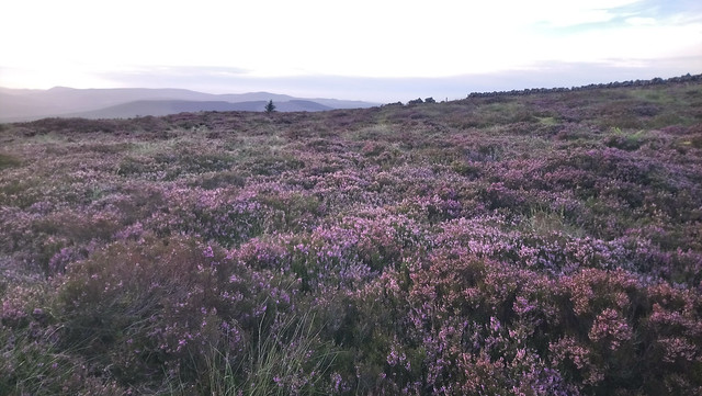
Hurklewinter Knowe was my first objective now I was on the Watershed proper but wearying of the tussocks when a handy but faint path appeared I cut the corner and soon was headed for the mast on the anonymous 482m spot.This is a good spot to see the hills of the Watershed where they run East to West before turning north into the Craik forest. I remember my first outing on the Watershed and my disturbed night between Bye and Dod Hills as the wind flattened my tent repeatedly,
 The path and the hills of the Watershed beyond from Greatmoor Hill to Wisp Hill (I think) Right to left.
 by
Seal54, on Flickr
 The mast finally getting closer.
 by
Seal54, on Flickr
 Mast and cairn with Larriston Fell beyond
 by
Seal54, on Flickr
I had wanted to go and investigate the Bloody Bush and the Border Stone ¾ mile to the south but by now I was eager to get on and get beyond Larriston Fell before stopping for the night. The mile from the border had eaten up another 90 minutes. Moreover, the surrounds of the mast were of interest themselves. Just below it on the western side was a giant roundabout equipped with what looked to be electric hook-ups of the type found in caravan parks. It seemed inconceivable that construction workers for the mast had required such a set-up. On the other side here was a good track up to the mast but hardly one that you would want to tow a caravan over. Nor did it seem the best place for a forestry workers’ encampment. I would be interested to know what it is and why it is there.
 Mystery roundabout
 by
Seal54, on Flickr
 Chopped off lampost and electric hook up.
 by
Seal54, on Flickr
“It’s a Mystery, I’m still searching for a clue…” Looking back to Huklrwinter Knowe from the roundabout
 by
Seal54, on Flickr
 Greatmore Hill and Maiden Paps (just visible when zoomed)
 by
Seal54, on Flickr
Iknow the sun is shining on them Golden Hills aheadI took repeated photos of the Watershed Hills to the north, perhaps to remind me that I had done them or to distract from the heavy weather I was making of the heather. I caught a glimpse of Keilder Water to the south so took a photo of that for balance.
 A sliver of Keilder Water just visible in the distance
 by
Seal54, on Flickr
Another ½ mile and 40 minutes saw me reach the trig point atop of Larriston Fells. Half way there I found a ghost of a path but it was easily lost. The heat, humidity, humps and heather had taken all my energy and now I needed to find a spot where I could lie low if thunderstorms broke in the night. The masts of Deadwater Fell were visible in the horizon with Peel Fell to the left.
 Looking over TP at Larriston Fell to Deadwater and Peel Fells.
 by
Seal54, on Flickr
 Looking back along faint path to mast
 by
Seal54, on Flickr
Larriston Fell was midway between the mast and the sharp corner of a fence that should take me onto Foulmire heights. The ground undulated ahead without significant height drop for further than I wished to continue so I turned north and dropped down to a sheltered hollow with a view out the tent door across Greatmore Hill and the Watershed snaking west. Despite the slow progress on through the tussocky ground I had made it further than I thought I would when planning at home. My fitness had held up but I wasn’t looking forward to more tussocks tomorrow.
 Evening Camp, again looking to them Golden Hills
 by
Seal54, on Flickr
11th AugustI fell asleep soon enough but at around 2.00 a.m. and was woken by a flash of light. Reassuringly it was 30 seconds before I heard the rumble of thunder that accompanied it but my sleep was disturbed and for the next few hours I counted the gap between flash and clap. the latter roling around the tent, The rain came and went, at times torrential.
“Thunder and lightning, very, very frightening”Reassuringly the storm came no closer, petering out around 5.00 am. but sleep continued to evade me. It was another sticky, close day and I felt as sluggish as the air. Hazy and with thunderheads to the south, I thought it prudent to check the forecast but couldn't a strong enough signal to access it. I tried to message my daughter so that she could check for me but that failed as well. Ahead lay miles of tussocks with no suitable escape route. In these Covid times hitching would not be an option and there was also forestry to get through. “Do not put yourself at unnecessary risk” was echoing through my head from MR advice for venturing out in these times (or was it the prospect of those miles of tussocks) as I packed my dripping tent and headed, not along the Watershed but back to the mast and another forestry track that would take me back to Newcastleton and the bus back to Hawick. I had bailed again.
“Ya running and ya running,
But ya can't run away from yourself
Can't run away from yourself”I kept trying for a signal, unsuccessfully and annoyingly given the proximity of the mast. I ran out of water on the walk back and I went a slightly different way than intended, I think the Queen of the fairies led me astray . It was actually no longer but I needed to be fortified by an ice-cream and soft drink in Newcastleton before catching the midday bus (just one other passenger) back to Hawick and onto my daughter’s in Edinburgh. By 9 pm I couldn’t keep my eyes open and headed to my bed and instant sleep. At 10 pm, a flash and almost simultaneous rumble woke me. The flash and rumble came again and again and again. I looked out of the window and across the roof tops. There was flash after flash of lightning, something I had only ever seen in Hollywood films. I was too tired to watch this spectacle for long and fell back into a deep sleep. Next day at breakfast it was all talk of the incredible thunderstorm across the eastern side of the country, the videos posted on line were of the continuous lightning. Roads were flooded and travel disrupted with ensuing chaos. At breakfast news also came through that the A68 had been closed as part of it had been washed away. Had I stayed on the Watershed I would have been stuck the other side of it if I had survived the night which would have been spent firmly in the path of the storm. Fortunately, my buses home from my daughter’s weren’t affected but as I was travelling further news came through of the fatal rail crash just south of Stonehaven caused by a landslip as a result of the rainfall. It felt very close to home. As I walked home from the bus, I passed a friend’s home only to find that she had been flooded. It certainly wasn’t a storm to be trifled with and whilst it had felt like cowardice at the time, I had made the right decision to bail. Hopefully I can return before too long.
