free to be able to rate and comment on reports (as well as access 1:25000 mapping).
Sub 2k Marilyns: Meall na h-Eilrig.
Date: 21/02/2021.
Distance: 11.5 km.
Ascent: 480m.
Time: 3 hours, 45 minutes..
Weather: Breezy, mild, some sunshine.
A windy weekend forecast, but with some sunshine due and most of the snow gone, we decided to head down to Drumnadrochit on Sunday to attempt Meall na h-Eilrig. Jackie had considered cycling to this from Inverness via Abriachan, but while she had managed a similar outing in July there was no way she was well enough to do that just now. So we toned it down and decided to approach from the south, where you can drive up to around 250m and park among the crofts at Drumbuie. I had a circular route in mind but if Jackie couldn't manage it then we could just come back down the same way.
Spring was finally in the air when we parked up, but the wind was howling. The views from these high crofts are impressive but access during the winter must be interesting! Passing through a gate which had an electric fence cable passing along it (we ducked underneath), we took a slight detour to avoid some cows then followed the farm track onto the moorland. One disadvantage of the recent snowmelt was that everything was really squelchy.
 Drumnadrochit and Meall Fuar Mhonaidh
  Cnoc Snataig
  Glen Affric hills
 Passing Loch Glanaidh, there were some spectacular glimpses of distant snowy hills, and Meall Fuar Mhonaidh dominated the south. At the edge of the woods, the track became more obscure and we did well to spot the fork shown on the map. Shortly after this we left the track - while it was hard to spot, it was pretty obvious once we were off it as the mossy, heathery tussocks became deeper! Fortunately the forest shown here is fairly young and more scattered woodland than regimented plantation, so there wasn't really any pushing through trees.
 Loch Glanaidh
  Beinn a Bhach Ard poking over the horizon
  Meall Fuar Mhonaidh
  Ben Wyvis
 The summit wasn't too far away but Jackie was struggling by now. We managed to find a spot out of the wind to have a break, which was probably our downfall. After the break, Jackie had recovered sufficiently for my circular route suggestion to sound appealing. I had previously approached this summit from the north and the west, finding the northern route to be like wading through soup, but the western spur to be reasonable. So I suggested we drop west towards Corryfoyness and pick up the Great Glen Way to take us back to Drumnadrochit.
 Beinn Dearg and Am Faochagach
  Across Loch Ness to Loch Duntelchaig
  Strathfarrar hills including Sgurr a Choire Ghlais
  Loch Ness and Meall Fuar Mhonaidh
  Ben Wyvis from Meall na h-Eilrig
  Little Wyvis and Ben Wyvis
 The ridge was OK, but Jackie struggled a bit in the tussocks and heather (which were no worse than our ascent route, but went on for longer), and was pretty much done in when we reached the Great Glen Way. The previous week we had walked up to Corryfoyness from Abriachan and she had ended up in the same state - from having to wade through snow rather than heather that time!
 Corryfoyness and Loch Ness
 Another break recharged her enough to feel OK about walking along the Great Glen Way, which is downhill on average and a well surfaced track. This is mostly uninspiring forestry, but with a couple of dramatic viewpoints out over Loch Ness. Lower down we left the waymarked route to follow less obvious tracks which stayed higher up the hillside - one disadvantage of parking at 250m above sea level is that we had to get back up there again. Off the waymarked trail, the woods were more interesting, with sections of silver birch and a good view out over Urquhart Castle and Drumnadrochit.
 Tom Bailgeann
 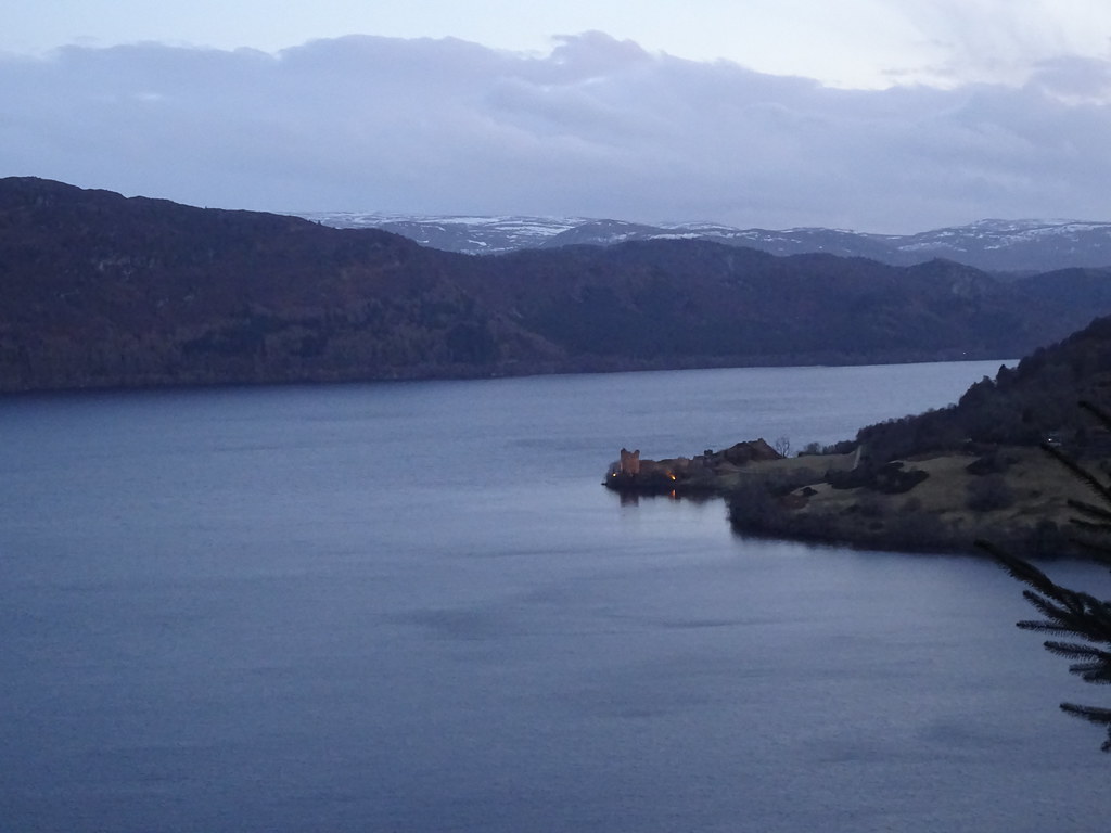 Urquhart Castle
 Some of the paths which climb back up to Drumbuie are a bit obscure and overgrown, so we ended up wandering through a field then a yard with a horse in it before picking up the end of the public road. There was still a mile or so to go from here with 100m of ascent, so I rushed on and got the car, while Jackie stumbled along for a bit until I met her and picked her up. I think we had probably misjudged the effort and bitten off more than Jackie could chew today, but we both enjoyed being out in spring-like conditions.
