free to be able to rate and comment on reports (as well as access 1:25000 mapping).
Our second day of Glen Loth wreck hunting started with serious doubts whether we'd be able to do anything at all. Weather in the morning was absolutely c**p. We drove up north in pouring rain, hoping that we might leave the cloud behind us, but when we arrived in Glen Loth, we still had to wait nearly half an hour in the car until weather showed the first signs of getting better. Our intended route for today was the circuit of Càrn Garbh (aka Wellington Hill) and Col-Bheinn, including Glen Sletdale and two plane crash sites, starting from the hydro dam on Loth Burn.
Route intended (and recommended):
Unfortunately, we had to change our plans and adjust the route because after the heavy downpour, Sletdale Burn transferred into Sletdale Torrent and there was absolutely no chance of crossing it at any point.
![2021-05-25 carn garbh 060.JPG]()
- Sletdale Burn photographed from the bridge at the bottom of Creag Riabhach
We ended up doing a T-shaped walk, involving a lot of bog-hopping and peat hag crossing - a true splogathon, as Kevin calls it. This option is a last resort when rivers are in spate. We still managed to visit both crash sites and claim the Sub'2 Marylin, but I'd definitely NOT recommend crossing the ridge between Col-Bheinn and Creag a'Chrionaich twice!
Originally, we wanted to use a good track into Glen Sletdale, but now we had to stay on the southern side of the burn, we thought, just as well we head straight up!
Good luck crossing this!
Instead of climbing up Creag Riabhach and traversing Cnoc na h-Iolaire, we opted to go straight up the middle shoulder, Creag a'Chrionaich:
Having crossed Allt a'Chrionaich and marched over some squelchy ground at the bottom of the corrie, we actually found the slopes of Creag a'Chrionaich quite easy and relatively dry. So far, so good:
Weather was improving (at least it stopped raining!) and the cloud was slowly lifting of Beinn Dhorainn. We were not that fussy about views today; we took enough photos of Caithness hills the day before. Today was all about the two crash sites: both were far more remote than the previous two targets!
![2021-05-25 carn garbh 001.JPG]()
- Beinn Dhorainn from Creag a'Chrionaich
The eastern cliffs of Càrn Garbh seen from across Glen Sletdale. Such a shame we couldn't see and photograph them from closer proximity. Our original route goes up the narrow glen on the left hand side:
On the top of Creag a'Chrionaich we came across a boggy ATV track which we followed for some time, but soon it turned into a muddy stream, so we gave up and simply hiked across the waterlogged ground to the next top (457m, not named on any maps). By now, we were already used to the lovely sound of our boots getting sucked into the soggy ground.
Gloomp!
Squelch!
Splash!

I should have brought my kayak!
On the next col (428m) we found a set of strange machinery. Aliens watching us?...
![2021-05-25 carn garbh 019.JPG]()
- Cloud monitoring station
We plodded on to the next unnamed top (505m) where we located another ATV track. It wasn't of much help though...
The Armageddon sky to the south of us:
From the 505m top we turned north, following the wide ridge towards Càrn Garbh. We encountered more bog and peat hags but at least weather was now looking reasonable.
The first crash site, one of Vickers Wellington Mk.IC R1093, is situated on the NW slopes of Càrn Garbh. The easiest way to get to this spot is from Strath Brora, using the access track to Gordonbush Windfarm, but we preferred our route despite the amount of peat hag dancing we had to perform

Actually, this is where Sletdale Burn is born, in the dip between Carn Garbh and Meallan Liath Mor:
With only 6 digit grid ref, we realized that we might still have to search a relatively large patch of ground, so we followed the stream into the dip and then planned to zig-zag uphill to scan the slopes. Luckily, Kevin spotted the crash site almost immediately and we climbed up to the scar:
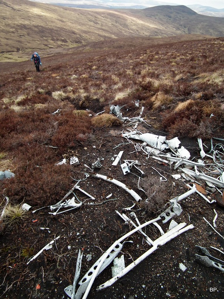
The large peat hag looks like it is plane-shaped so we were under the initial impression that this was where the Wellington hit the hill. Later, we found out that the actual impact scar is much higher up the slope and this is just where a large amount of wreckage ended up, either dumped in the hag or simply tumbled down here.
In the peat hag and just below it, we found a lot of smashed up bits of aluminum, parts of geodetic frame, pipes, cables, fuselage panels, undercarriage assembly, even a wheel, complete with a tyre though flat as a pancake. We were fascinated by the wreckage and spent probably half an hour photographing every detail, trying to guess which part of the aircraft particular pieces came from.
 2021-05-25 carn garbh 046
 by
Kevin Dalziel, on Flickr
The Vickers Wellington was a twin-engined long-range medium bomber, powered by two Bristol Pegasus radial engines. This particular plane was the Mark IC variant, one of 2,685 produced overall. The Mark IC had a crew of six: a pilot, radio operator, navigator/bombardier, observer/nose gunner, tail gunner and waist gunner.
![2021-05-25 carn garbh 122.JPG]()
A key innovation of the Wellington was its geodetic construction, built from no less than 1650 elements! It was a giant puzzle of duralumin beams formed into a metal framework, fixed together by wooden battens screwed to the beams. The whole structure was then covered with Irish linen, treated with layers of dope, forming the outer skin of the aircraft. This innovative construction proved to be versatile and compatible with many adaptations like heavy all-up weight, large bombs, tropicalisation and the addition of long-range fuel tanks. Vickers Wellington was therefore used extensively during WW2. It could reach maximum speed of 235 mph (378 km/h) and their service ceiling was 18000 ft (5500 m).
 2021-05-25 carn garbh 114
 by
Kevin Dalziel, on Flickr
Today, there are two complete Vickers Wellingtons still surviving in the UK, both in museums, though neither is airworthy. I have never seen a complete Vickers and probably never will, unless we decide to go on some kind of air museum tour when the COVID situation is solved (at the moment many museums are still closed or have restricted access). So sad that the only way we can get to know these legendary machines is to examine the broken and destroyed ones...
Probably a part of fuel tank:
 2021-05-25 carn garbh 124
 by
Kevin Dalziel, on Flickr
This particular aircraft, belonging to No. 20 OTU, set off on 30th July 1941 on a navigation training flight from the RAF base in Lossiemouth. The reasons of the accident are not known; possibly bad weather contributed to the crash? The plane flew into the north western side of Carn Garbh and collided with the slope at the height of 510m. Four crew members were killed but two (the pilot and the wireless operator) survived the crash.
One of the internet sources suggests that the two engines are still on site but were buried by the recovery unit. Maybe one could locate them using a metal detector, but we are far from such silly ideas. There was enough to investigate on the surface, anyway!
Close up of the tyre with the name of the producer, "Dunlop" still visible:
More of the "lattice" structure of the wings:
In the second peat hag, a few meters to the right (as facing the slope) we found some more wreckage:
We knew this wasn't all so headed uphill, scanning the heathery ground around us. It wasn't long till we came across more...
 2021-01-25 carn garbh 070
 by
Kevin Dalziel, on Flickr
... and more...
...until we reached the impact zone:
 2021-01-25 carn garbh 107
 by
Kevin Dalziel, on Flickr
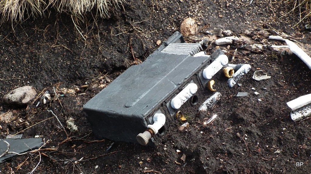
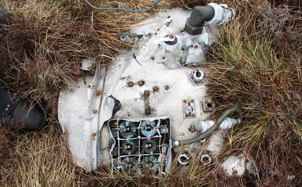
Here, there was a mind-boggling number of small pieces to photograph, including the aircraft’s receiver from the wireless operator’s station:
Burnt-out battery:
 2021-01-25 carn garbh 134
 by
Kevin Dalziel, on Flickr
The second undercarriage assembly:
 2021-05-25 carn garbh 254
 by
Kevin Dalziel, on Flickr
Burst oxygen bottle:
 2021-01-25 carn garbh 108
 by
Kevin Dalziel, on Flickr
Not sure about this part, a section of fuel tank perhaps?
 2021-05-25 carn garbh 210
 by
Kevin Dalziel, on Flickr
Looking down the NW slopes of Carn Garbh from the crash site, Gordonbush Windfarm on the horizon:
 2021-01-25 carn garbh 153
 by
Kevin Dalziel, on Flickr
Again, we lost far too much time photographing all the little details of the accident site...
...so by the time we eventually left the Vickers Wellington behind and walked the short distance to the summit of Carn Garbh, it was already half past two.
Lucy on the summit. There is no cairn, but a tuft of moss marks the highest spot:
 2021-01-25 carn garbh 166
 by
Kevin Dalziel, on Flickr
With no time to faff about, we had a quick snack bar and headed back to the 505m top, over the ocean of squelchy grass, moss & heather, over the countless peat hags and muddy puddles. By now, we were seriously fed up with the splogathon we had to endure, but since we were already here, just as well, we wanted to visit the second crash site.
![2021-01-25 carn garbh 179.JPG]()
- Barracuda, here we come!
Conditions have improved since early morning:
We descended the 505m top and aimed south for Col Bheinn, over another peat-haggy bealach. The top of Col-Bheinn proved a good viewpoint. It has a trig point (visible in the photo below to the right):
...but the true summit (according to Kevin's GPS) is about 50m to the west, no cairn marking the exact spot.
![2021-05-25 carn garbh 305.JPG]()
- A summit like many others...
Posing with the Gordonbush Windfarm in the background:
The second crash site we were looking for today is located on the southern slopes of Col-Bheinn, about 70m below the summit. We couldn't see it from above but had a six-digit grid ref so headed in the direction our GPS was suggesting:
We found the Barracuda very quickly. The biggest feature of this crash site are no doubt the wings of the aircraft, still connected by the center section:
Next to the wreckage, a small memorial plaque was placed, giving the names of the three crew who lost their lives here:
I was already emotional after seeing the carnage on the Wellington Hill, now the simple message on this little board really hit the spot. The three lads who died here in 1945 were so young. 19-20 years old, come on! Just kids, for heaven's sake. YOUNG KIDS who had their whole life to live, jobs to work, girls to marry, families to raise, houses to build. And they ended up dead on this remote slope. Why??? Because one greedy man with a small moustache had a bad attitude

There is very little info available about this particular accident. According to "Aircraft Wrecks: The Walker's Guide", the crew were flying from RNAS Fearn, HMS Owl, near Tain when they flew into the southern side of Col-bheinn. Perhaps it was just a navigational error (they were just trainees after all) or maybe the cloud obscuring the view contributed to the crash. Sadly, we will never know.
![2021-05-25 carn garbh 312.JPG]()
The Fairey Barracuda was another ingenue design, a British carrier-borne torpedo and dive bomber, the first aircraft of this type operated by the Royal Navy's Fleet Air Arm to be fabricated entirely from metal. For storage, the wings folded back horizontally at the roots. Powered by one Rolls-Royce Merlin 32 V-12 liquid-cooled piston engine, the Barracudas were extensively used during the WW2 in the operations over the Atlantic Ocean, Mediterranean Sea and the Pacific Ocean against the German, Italian and Japanese forces respectively. Often they flew from aircraft carriers. They took part in the famous attack on the German battleship Tirpitz on 3 April 1944.
Sadly, not a single complete Barracuda survives till today, but if you are interested in aviation, you can read more about The Barracuda Project in the Fleet Air Arm Museum
HERE.An armour plate:
Small details of the surviving wing structure:
Modern graffiti on the wing flap. Of course, there are always idiots who think that scratching their names on a war memorial is funny!

Small pieces of the plane in the nearby peat hag:
 2021-01-25 carn garbh 216
 by
Kevin Dalziel, on Flickr
To return to the starting point, we had a long way to hike across the peat hag hell, so we didn't waste any more time:
 2021-01-25 carn garbh 223
 by
Kevin Dalziel, on Flickr
We took a shortcut crossing another boggy corrie and returned over the 457m top to Creag a'Chrionaich. From here, we still had another wet glen to negotiate before we could pick the ATV track on Creag Riabhach. Luckily, weather held on for the rest of the afternoon.
Creag Riabhach and Beinn Mhealaich from Creag a'Chrionaich:
 2021-01-25 carn garbh 232
 by
Kevin Dalziel, on Flickr
One could ask why we bother. Hard to answer this. I don't want to say that we visit the crash sites for pure entertainment value, though looking for them is a kind of adventure in itself. I find these sites fascinating but also deeply disturbing. At the same time, I'm so thankful to the young, brave men who sacrificed their lives during the big conflict. Telling the stories of the crashes is just a way to remember. We owe these lost boys at least as much.
In my next report we will take a break from Panther's Aircraft Investigations and climb a remote Graham with a chance of cheesecake. TR to come soon.
Bibliography:Internet sources:
https://www.peakdistrictaircrashes.co.uk/crash_sites/scotland/vickers-wellington-r1093-carn-garbh/https://her.highland.gov.uk/monument/MHG30819http://www.wtdwhd.co.uk/CC18/Day8-9.htmlhttps://en.wikipedia.org/wiki/Vickers_Wellingtonhttps://her.highland.gov.uk/monument/MHG30842http://www.wtdwhd.co.uk/CC18/Day7.htmlhttps://www.peakdistrictaircrashes.co.uk/crash_sites/scotland/fairey-barracuda-pm870-col-bheinn/http://www.scottishhills.com/html/modules.php?name=Forums&file=viewtopic&t=1633https://www.fleetairarm.com/barracuda-restoration-project.aspxBooks:
1. Aircraft Wrecks: The Walker's Guide: Historic Crash Sites on the Moors and Mountains of the British Isles. (2009)
by Nick Wotherspoon, Alan Clark and Mark Sheldon
2. Wrecks & Relics: 27th edition: The Indispensable Guide to Britain's Aviation Heritage (2020)
by Ken Ellis
