free to be able to rate and comment on reports (as well as access 1:25000 mapping).
With various errands taken care of at home (most notably getting my second Covid jab!

), I had a brief window of time to escape once again to my northern bolthole. I was a bit sad that those creature-free days of late spring were gone, and based on the midges and ticks I’d been victim to at home, I could only be wary of what the situation might be in the northwest! Hey ho, you live in Scotland; get over it. On the bright side—at least the clegs and keds aren’t out yet.
 Fri 18 Jun
Gaick Corbetts: An Dun, Maol Creag an Loch
8¼ hrs / 28.43km / 1118mI’d had a very early start after what had been a late night, so it’s fair to say I wasn’t at my best. I set off walking from the A9 at 6:45am. After marching some distance up the track, I realized that, AGAIN, I’d forgotten to put my contact lenses in. This is becoming a bit of an annoying habit, as it’s less than ideal to put them in on the side of a mountain, or at the side of a track, or really, anywhere other than the car. I stopped and put it to rights (at least I’d remembered to replace the “spare” pair in my pack), and was soon on my way again.
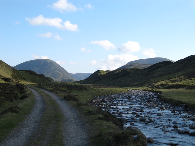
first view of my targets
The track was familiar to me, as I’d had a recce of these two hills several years ago; turned back by high water at the Edendon crossing, only about a km from Sronphadruig Lodge. Today, the water was so low that I had difficulty imagining how it had ever been so high as to not only spill over the concrete bridge, but to spill over so enthusiastically as to be knee-deep!

hard to imagine this being uncrossable...
The ascent up the nose of An Dun was steep, but I did soon find the path that wound its way through the grass, heather, and occasional rock. I sat at the cairn for a few minutes, before realizing it wasn’t “the” cairn. I carried on to, but didn’t stop at, the actual summit cairn, a little apprehensive about what I knew was going to be a steep descent back down to the river crossing. The good news is that it was very dry underfoot; I think this walk would have been much more difficult and slippy under “usual” conditions.

the lovely Gaick Pass
What came as a surprise was how ridge-y the ridge-y bit was. There was a fairly steep drop-off on either side, and I made my way carefully and slowly across most of it, before deciding to drop slightly to my right side to alleviate the exposure. The descent was, as promised, very steep, but taking it slow and steady was the key. The river crossing and surrounding usually boggy area presented no difficulties.

the ridge-y bit

the steep grassy slope I'd descended
After taking a break on the landrover track for food and water, and having a recce of the directissimo route (

) I decided to follow the WH route—“marginally less steep”—up the second Corbett. Wowie, marginally less steep was still bloody steep. The effect of not enough sleep reared its ugly head, and I stopped often to catch my breath, rest my legs, and ponder my options (knowing in my heart that really, there weren’t any but to carry on; calling it quits from this point would be madness—descend, and walk all the way out along the track, having to do that long walk in again at another time? I think not.)

looking back down from my second ascent
With huge relief, I finally reached the point where the gradient eased, and carried along to the small summit cairn. Nice views from here, but the broad flat plateau, and a bit of haze, plus my usual lack of orientation when in the middle of the country, meant I couldn’t conclusively identify many (any) of the surrounding hills.

broad flat summit, looking toward various Perthshire hills
I carried on along the plateau, lost a lot of height via several very good paths, and eventually picked up the deer track that traversed Meall na Spianaig; this was a difficult km or so, the track being very rough, and hard to follow at times.
along one of the nicer descent paths
I eventually landed on the outward track, and began the long march back. Nowt to do but put your head down and get on with it (again). I’d been lucky with the weather; although I was quite warm when the full sun was out, and wished once or twice that I’d worn shorts, there was a fair bit of high cloud, and a very welcome breeze that seemed to know just when to blow. Nearly perfect walking conditions.

the long road home
The rest of the drive up to Inverness was uneventful, aside from the usual frustrating and stupid Friday afternoon traffic.
Sat 19 JuneMore or less a rest day. I was knackered from the day before, and the forecast for the NW wasn’t very good. I took a wee wander around the UHI campus, just to get some fresh air and move around a little. I didn’t realise that the “retail park” signs along the path actually meant the big retail park just off the A96!
Sun 20 June
Beach wander: Burghead to Lossiemouth, via the caves, incl the Sculptor’s Cave
5 hrs / 18.2km / 215m The weather in the NW still not very good, so we put Baosbheinn on hold—again!—and opted for a wee beach walk instead. We met in Lossiemouth and left my car there, while Evie drove us through to Burghead.

beach huts in Moray! Who knew?
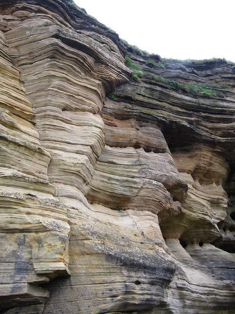
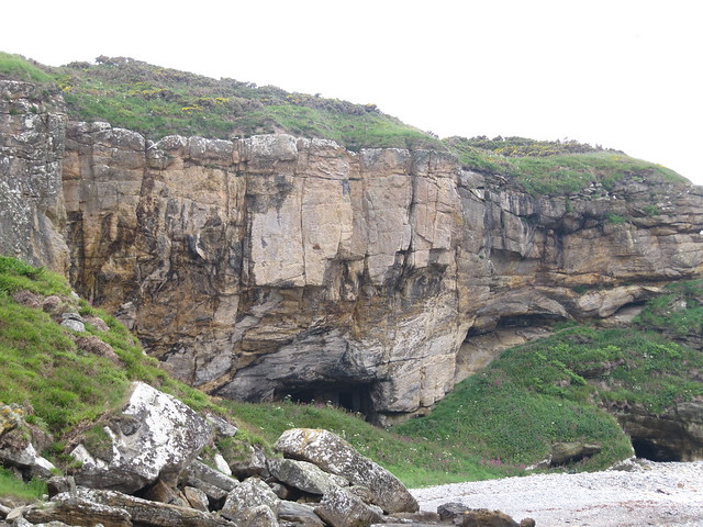
We were on the Moray Coast Trail for nearly all of the walk, until we reached the Coast Guard lookout tower, and from there, descended down to the beach to turn back on ourselves and make our way back along the shore to a large sea stack, multiple smallish caves, and then, a bit further along, the large Sculptor’s Cave.
Just as we turned to make the descent down to the beach, Evie caught sight of dolphin fins off the shore. We watched, mesmerized, as a large pod—impossible to tell how many—leapt and swam their way east. It was a magic moment; one of those times that’s it’s better just to watch, and enjoy, rather than faffing about with a camera only to end up with mediocre (or worse) photos.
The caves, and cliffs were spectacular, and we spent a lot of time taking photos, and looking at places where large blocks of rocks had fallen from above (still topped with vegetation). It was slightly unnerving.


spot the Evie!

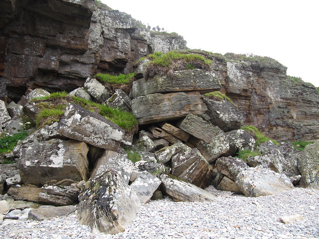
fallen blocks -- yikes!
Sculptor's Cave

We reached Lossiemouth early enough to have coffee and cake at the Harbour Lights. An oh-so civilized ending to a fab beach day. Is there anything better than a beach wander?? Well, maybe a high Cairngorm wander…watch this space!
Mon 21 Jun
Graham: Carn nan Tri-tighearnan
5½ hrs / 19.45km / 675m This Graham is the only one in the immediate vicinity that I’d not yet visited. I wasn’t sure I wanted to, given the multitude of references to the endless peat hags in ALL of the walk reports I’d read. Most of those reports even referred to the hags in their titles. Oh, goody, sign me up!
But today, this walk actually fit the bill perfectly. I wanted to do something not too strenuous, as Evie and I were planning another big day—maybe Baosbheinn, we’ll see—for the next day, Tues. The weather had been quite dry, so the dreaded peat hags should at least be in better shape than if it had been raining torrentially for days on end. And it’s close to home, really, just up the hills behind (to the east) of the house, beyond an area I’d been wanting to explore anyway. I gave myself permission to turn back at any time, for any reason, without having regrets. We’d just see how it went.
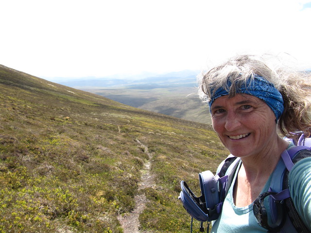
I have to admit that I enjoyed the day more than I’d anticipated. I parked up on the minor road near Finglack farm; about 4 miles from the house. There’s a good track all the way up to Beinn Bhuidhe Mhor (548m), and then the fun really starts. A steep descent, then reascent, up to Carn Dubh Mor. I had a “will I, won’t I?” break here, as dark storm clouds threatened from the north. I *really* didn’t want to be caught out in the featureless-except-for-deep-hags terrain in poor visibility! But the clouds mostly passed by, and when the sun came out again, I started to make my way across the nearly 3km to the summit.

trig point on BBM; that's the easy bit done...

I quickly learned that it was most efficient to stay down in the depths of the hags, and continue making my way in the general direction of the summit, and climbing up out of them only when they briefly ended, and to check that I wasn’t headed too far off course. I developed a bit of a rhythm, and because they were bone-dry, it wasn’t nearly as much work or stress as I’d imagined. It just took forever to make discernible progress!

it's a peat-hag world


I could see the trig point on the summit from quite a distance, but it never seemed to be getting any closer. But I did eventually get there, and was disappointed that on this hazy day, the only thing that I could see clearly was 3 wind farms in 3 separate directions. I didn’t stick around for very long before heading back the way I’d come.

trig point / summit...at last!
I traversed Carn Dubh Mor to avoid descending its steepest bit, but I still had the ascent back up to Beinn Bhuidhe Mhor to look forward to. Although, tbh, with less than 700m of ascent across the entire walk, none of the ascents/descents were particularly brutal. Near the summit of BBM, I picked up the track again, and followed it back to the start. Although the rain and dark clouds continued to threaten throughout the day, I managed to escape the rain, except for a few spits and spots, until I was only about 5 minutes from the car. At which point, it started raining more enthusiastically. So I was a bit damp.
But it was only about a 10-minute drive to a hot shower.
Tues 22 June
Cairngorm wander: Glen Feshie to the Wells of Dee
8½ hrs / 25km / 1340mAs I drove toward Aviemore, it occurred to me how fortunate I am to be able to spend time in the Cairngorms without having a “hill” agenda. From home, it’s just too far to travel to only have a wander, without a specific destination or goal (hill) in mind. And yet, several of my most awesome recent adventures have been “tick-less,” or perhaps I should say “blue-balloon-less,” to avoid confusion about the crawly type of ticks versus the checking something off a list type.
We met in Glen Feshie, with a plan of walking across the Moine Mor to the Wells of Dee, high on the plateau between Braeriach and Sgor an Lochain Uaine. We set off up the path toward Carn Ban Mor which was a bit of a slog, but needs must, as it provided the most efficient way to reach our goal. When we reached the “junction” of paths, we headed off toward the summit of Carn Ban, but soon found ourselves losing a bit of height, and heading toward the rim of Coire Odhar, affording a spectacular view of Loch Einich and Sgor Gaoith.

spectacular Loch Einich; Sgor Gaoith on the left, Braeriach on the right (both off camera)
After a fair bit of up and downing around the rim of the coire, we began the long and steady climb in the general direction of Carn na Criche (1265m). Our progress was slow, but there were a lot of orientation lessons going on during this time! (“Evie, what’s that hill there?” “Evie, which one of these is Monadh Mor?” “Evie, what direction is Blair Atholl from here?” “Evie, how far have you walked up Glen Feshie?” etc., etc., etc.). Evie being the Cairngorm Queen, and Karen not.

we aimed more or less for the summit of Braeriach
The Wells of Dee themselves were somewhat underwhelming. The small herd of reindeer we spotted, and who barely afforded us a second glance, more than made up for any small disappointment. The spot we stopped at first still lay under a large patch of snow, so we couldn’t actually find the spring itself. But we both had a wee drink, not bothering with a filter, being this close to the river’s source.

'allo, all
By this time, we were rather peckish, but the broad flat area didn’t offer much of a view—from this perspective, Braeriach is, dare I say it, somewhat less than its usual spectacularness. We decided to ascend “just a bit further – over there” in search of a more entertaining lunch spot. Well. Before too long, we found ourselves near the Falls of Dee, staring across to The Angel’s Peak and down onto Coire an Lochain Uaine, and into the abyss that is An Garbh Choire. Wow, wow, wow. We sat for quite some time, in sunshine and shirtsleeves, and revelled in yet another spectacular Cairngorm plateau adventure. The pictures, of course, as usual, won’t do the setting justice.

The Angel's Peak + Cairn Toul (Lochain Uaine left center)

Braeriach + the Falls of Dee

Evie at the edge

Macdui, across An Garbh Coire

happy lassies!

We eventually made our way back down to Loch nan Chapan (one of the more pleasant descents I’ve ever done, I must say), which we also realized wasn’t particularly far away from Loch nan Stuirteag, which was the point to which Jimmy and I descended off The Angel’s Peak toward Monadh Mor during THAT trip several years ago.
Before long, we were back at the path ascending toward Carn Ban Mor, and from there, the path back down to the car park at Achlean. We didn’t get back in time to go for cake and coffee, but oh, well. It was a small sacrifice to make for what had been another memorable and happy outing.
Wed-Thurs, 23–24 JuneNot much of note to write about; the weather wasn’t great, especially the mountain forecasts. On Wed, I drove to Beauly and had a bit of a wander around the priory and the village. Early on Thurs morning, I drove to Nairn, and had a walk along the beach, before the rain settled in for the day. I stopped in at the Cheese Pantry on the way home, and enjoyed a bread-and-cheese lunch, along with a cheeky glass of wine (I do love being retired!).

ancient Sycamore at Beauly Priory

Beauly Priory
Fri 25 June
recce of Baosbheinn
5 hrs / 19.75km / 532m So, the forecast WAS a bit iffy. But honestly, it was meant to be dry (but windy) in the west…
We had an early start from Inverness, and made good time driving through to nearly Gairloch. It’s been an eon since I’ve been there, and driving the road that used to be so familiar made me want to go and stay there again. But it just wouldn’t be the same now, without “my” B&B, and usually wanting to climb higher hills from more convenient locations. Ach, well, good memories anyway.
So the march up the track toward the hill was familiar as well, and also holds memories. The first time I headed toward the loch, but couldn’t get across the raging river. I felt brave anyway, because that was in the early days of exploring new territory on my own. And the next time, when it felt like a real victory to reach the loch, after managing to cross the stepping stones over gentler waters. The time that David, Evie and I climbed Beinn an Eoin; a fabulous day.
Today, the cloud stuck stubbornly to the hilltops. A light drizzle became somewhat more persistent, although thankfully, that didn’t last for too long. Neither one of us was keen to go up the hill without much hope of views, so we decided to carry on to the loch, and make the call when we got there. I’d read in a walk report—rockhopper’s, I think—that the wee boathouse was unlocked at the time he was there. We had a look, and sure enough, it was securely latched, but not locked. There were even a couple of camping chairs, so we had a rather lengthy break and discussed options. We decided that if we could see to the end of the loch when we emerged from the hut, we’d carry along to the fishing bothy at the end. Who knows, maybe even by that time, the cloud might shift from the summits?

harvin' a cuppa in the wee fisher hut
It seemed further than I remembered. When we got there, not only was the clag stubbornly hanging on, but we realized that the wind was quite strong as well—we’d been walking with it at our backs, and it wasn’t until we turned around that it dawned on us that it was going to be hard work walking into the teeth of it.

the best of the views...didn't last long...we'll be coming back to get ya!
We did catch a couple of glimpses of the summit and ridge on our way back along the loch, but were happy with the decision to save it for another day, given the added challenge of the wind. Nearly 20km of walking, and a bit of ascent, but no blue balloons today. Coffee and cake at The Midge Bite, as per usual (when we’re not too late off the hills!).
Sat 26 JuneLoad up the car and drive home. There's a compleation outing / celebration to plan!
