free to be able to rate and comment on reports (as well as access 1:25000 mapping).
Another boiling hot weekend in prospect. I was somewhat preoccupied by a bit of a garden problem: my pond had sprung a leak and needed extensive work to find and patch the hole(s), so this had taken a good deal of my time during the week and I didn't feel up to going away before Friday morning. I was also a little apprehensive about walking all day in the heat - I'd been finding myself wilting between 3-6pm when the sun felt at its hottest. Where to go? I'd got a bit centred on Area 5 and thought it would be an idea to head up to Dalnaspidal for 4 Corbetts plus some Simms - if I'd time I could add on Beinn a'Chuallaich as a solo quickie.
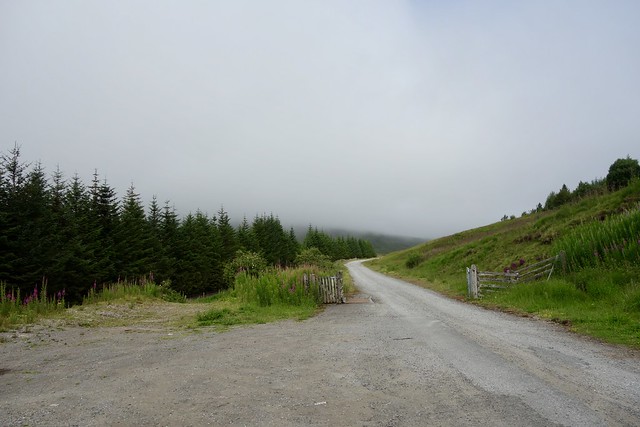
Set off just before 8 on Friday morning - amazed the traffic through Glasgow was so quiet - must be the Glasgow Fair effect. Anyway, I arrived at Dalnaspidal in good time, before 10.30. I was planning to climb The Boar of Badenoch (or An Torc) then The Sow of Atholl to begin with - these two hills sit at the gateway to Coire Dhomhain. A steep start. Actually I thought the Bore of Badenoch was one of the honorific titles given to Jeremy Clarkson when he travelled to Scotland

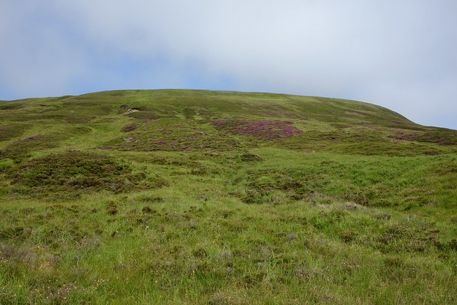
I walked along the old A9 / cycle track in the mist, knowing it would burn off before long. No problems crossing the river today, you'll not be surprised to hear. I walked along the track alongside the river for a bit then just turned uphill (actually there is a zigzag track a little further on, as I spotted on my way up The Sow) - but it's a fairly easy gradient and the heather's not too long. The summit gives a good view to A'Mharconiach. Down again, back onto the track and across a new footbridge to The Sow. I followed a track going to Gross Butts some of the way up, then deer tracks to the top. Much easier than An Dun

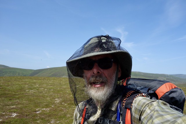
Clegs were quite bad and I made use of a midge net I'd bought on eBay - hopeless for midges as the holes are too big, but good for clegs and larger flying creatures.
 F3B645E8-CC39-46C7-810B-817C91EA3B06_1_201_a
 by
Al, on Flickr
Sow
 012B1EE3-C1DB-4B8A-A601-F9BFD3E27EDE_1_201_a
 by
Al, on Flickr
Boar
 853EDF0A-5C0F-4AB2-9000-03DE6A019649_1_201_a
 by
Al, on Flickr
A'Mharconaich
 627FF516-DA0A-443B-82A0-1AA37ED62C44_1_201_a
 by
Al, on Flickr
Cleg net at the top of the Sow
 DCDBCF3D-3FA5-4905-954C-DCC6E79B9256_1_201_a
 by
Al, on Flickr
The Simm of Meallan Buidhe was next - this lies SW of The Sow. I could have gone over Sgairnich Mhor to reach it, but I dropped down into Coire Luidhearnaich and picked up and ATV track which led more or less to the summit. Then it was over Mam Ban for a line of Simms running to the east of Loch Ericht - largely trackless although there were occasional ATV tracks. Glas Meall a'Chumhainn was the most taxing of the hills - it was a subMarilyn, only 3 metres off being a Corbett. And I was tackling it at the hottest part of the day. Hot work. From there I had one further wee Simm before heading west to climb Stob an Aonaich Mhoir, my second Corbett of the day. On both previous occasions I've approached this on the long, tedious track from Bridge of Ericht - this was a more interesting route. I crossed over the track, hoping there would be some water on my way to the summit, as I was planning to camp there tonight and needed to top up - fortunately there was. As I headed up I kept a lookout for camp spots, doubting I'd find a spot at the summit, but I managed to (although it was perhaps a little lumpy). It was about 9.30 by the time I'd pitched - I looked over to Bheinn Bhoil and Ben Alder, thinking we must head over there again soon. Off to bed with The Remains of the Day.
Meallan Buidhe
 73AD3959-62A1-4C4D-8F48-9A76798B44FC_1_201_a
 by
Al, on Flickr
Loch Ericht
 5BC7BDC7-1BEF-4563-AEE5-D6671BCA5BE7_1_201_a
 by
Al, on Flickr
 8D05BB83-2849-4401-854B-B7ACDC8D1E91_1_201_a
 by
Al, on Flickr
Stob an Aonaich Mhoir
 EF60B6A3-9754-4E22-AFD8-D5D6348CD0E7_1_201_a
 by
Al, on Flickr
 909543C2-7CD9-4250-9430-EF21AECE3951_1_201_a
 by
Al, on Flickr
 D2F23135-6636-4CB9-A9E3-8868A7A39608_1_201_a
 by
Al, on Flickr
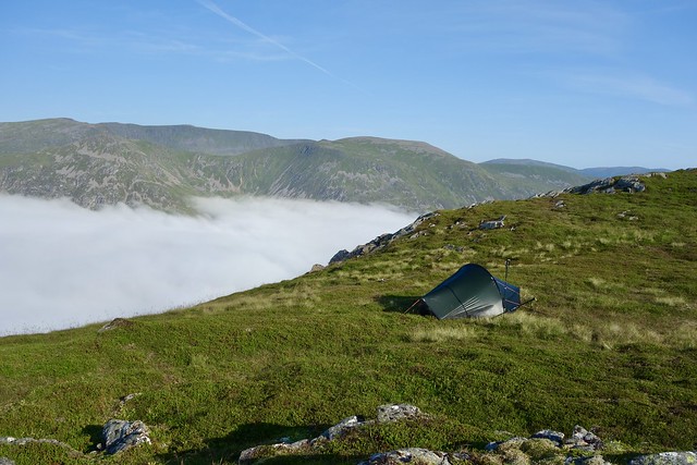
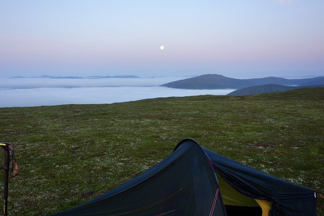
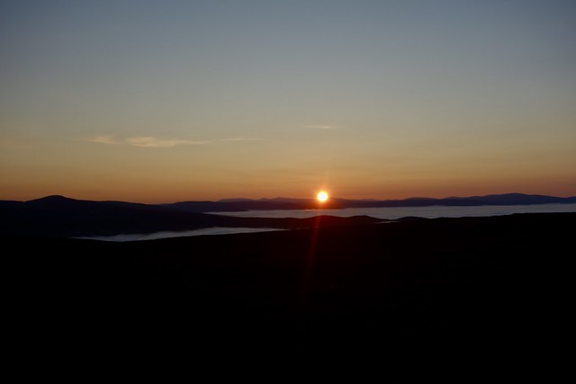
I woke during the night, noting it was a full moon, and there was probably a cloud inversion over the loch, but there were too many midges about to risk leaving the tent. I woke again about 4 to see the moon had turned pink and was sitting over a sea o white. By the time I actually got up, day was well and truly risen, but the inversion was still there, stretching over the full horizon. Shiehallion sat, pointed head floating on a sea of cloud. There's something quite magical about the way an inversion transforms the appearance of the landscape - maybe a bit like snow can change a prosaic scene into something other. I nipped about taking some photos, then set off for Beinn Mholach - the "Hairy Mountain", via another couple of Simms. I sat and had lunch at the summit, hearing another laker approaching when he made noise walking over rocks - never make a stalker! Anyway, he'd cycled in from Dalnaspidal to the end of Loch Garry.
Pink Moon
 6F87F537-4E24-40A6-A75F-C0498A4BC32C_1_201_a
 by
Al, on Flickr
 6637CDF5-5BF5-42F8-9A58-3D97844FD4C7_1_201_a
 by
Al, on Flickr
 469D5A6E-D588-4564-98AD-3826FC782D36_1_201_a
 by
Al, on Flickr
 D60E1BA9-1D23-477A-BB93-99B85D29DA74_1_201_a
 by
Al, on Flickr
 BD38E3DC-2FA8-4146-B90E-A7614D7EC784_1_201_a
 by
Al, on Flickr
My way ahead
 4013F9CA-9D6E-4C7A-9CE1-B8F080BA4277_1_201_a
 by
Al, on Flickr
Pointy Schiehallion
 744CEE2A-A3A7-4E30-A140-FCF749A3BE2E_1_201_a
 by
Al, on Flickr
Bheinn Mholach
 6B080C8A-9E95-4550-ADD7-ADF4285FEABB_1_201_a
 by
Al, on Flickr
 93E46FC4-7468-442C-93B5-B2F1EA6B3013_1_201_a
 by
Al, on Flickr
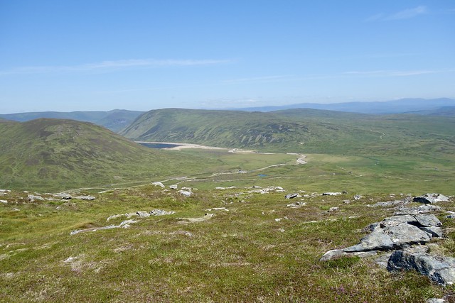
That was the way I was heading, to return to the car over Meall na Leitreach. But of course there was another Simm to be added, the annoyingly far out Meall Breac. I noticed a track, not on the map, which seemed to be headed my way up the back of Meall na Leitreach, so I decided to make for that. This involved a river crossing at the end of Loch Garry, which might, under normal circumstances be a bit challenging, but not today. I stopped to take on water, noting the foetid stench of dead deer - fortunately I could see the carcass on the stones away from the water, but it did almost make me retch as I was drinking my water (and I have a fairly poor sense of smell). Onwards along the track, finding a cluster of more than a dozen spent cartridge cases in one spot. Sheep around and more new Gross Butts - they're everywhere on Leitreach. The track did serve me well, taking me to the bealach between Meall Breac and Leachd nam Fuaran. I then had to traipse over endless peat hags towards a summit that for ages I couldn't even see and when I did, it was one of those that never seemed to get nearer. This would be murder if the peat hags were in their usual state, you'd waste a great deal of energy having to detour round them. Most could be walked over at the moment however.
 8EE9F4A9-3634-49CA-85D1-902569B1EEC1_1_201_a
 by
Al, on Flickr
Meall Breac - finally
 994F0C71-161E-4A46-BEF1-811F21C056AF_1_201_a
 by
Al, on Flickr
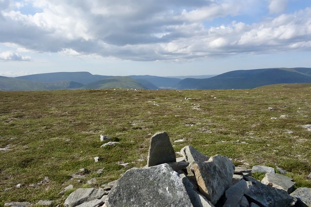
I finally reached the trig column and slumped down. I had thought that I might finish off Leitreach and he'd over to Beinn a'Chuallaich to camp there, but the energy had left me. Instead I resolved to camp on top of Leitreach and get up early for the final hill on Sunday. I followed the fence line on the way back from Breac, which helped a little, then found an ATV track, passing more damned Butts heading up to the summit of Leitreach. No potable water however - I reckoned I had just enough to last me overnight. I got to the top earlier than I'd expected, about 5.30 and set up the tent on the flat summit, then made my tea. There was enough breeze to keep the beasts at bay and the pitch was flatter than last night - only slightly disappointing thing was being able to hear louder vehicles from the A9. I settled down to an early night, finished my book and tried to sleep. The sunset was a bit meh.
Summit Leitreach
 A55F5251-67C6-49CA-8B3E-16393141F326_1_201_a
 by
Al, on Flickr
 08F05D88-AFB8-4273-89CB-01F039F7E4C1_1_201_a
 by
Al, on Flickr
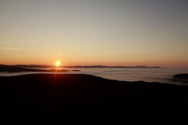
I did wake just as dawn was breaking - another inversion, this time with the red glow of the sun coming up. I pulled on my belay jacket and headed out in my bare feet to take some photos. What a beautiful view, especially as the red globe of the sun emerged about the hills. I decided to just have my breakfast and head off the hill, with a big smile on my face. I passed into cloud at about 580m. On the way back to the car I walked past the estate buildings, at around 6am - each had their kennels out front and the peace was shattered by the yowling of numerous dogs as I passed by. I bet I was popular
 542B265B-5CFD-4099-9D84-81AC9B333859_1_201_a
 by
Al, on Flickr
 2A842323-9C26-4488-930C-CF4639385934_1_201_a
 by
Al, on Flickr
 59A70CD8-5560-4141-BB8A-54AE57055288_1_201_a
 by
Al, on Flickr
 DE9FC381-BC31-4223-AD9E-5D4820D0E0AE_1_201_a
 by
Al, on Flickr
 E947ED5B-6650-4774-B4C4-1F9E047F0F78_1_201_a
 by
Al, on Flickr
 A732EAE2-0AC3-4612-9E81-C41255D458FA_1_201_a
 by
Al, on Flickr
 5A199AB6-4E0E-4D99-8B70-27C832FC8C4E_1_201_a
 by
Al, on Flickr
 56FACF35-CEFF-4025-9077-AA26F338A8E2_1_201_a
 by
Al, on Flickr
 7F41BC89-5EAE-4B9D-A6EF-AC21D15ED0CB_1_201_a
 by
Al, on Flickr
The Sow
 C6808CDE-4B2F-4AC2-95A3-E8A03BF0EF84_1_201_a
 by
Al, on Flickr
Descending into the clouds
 DB8A32BC-AB1E-420A-BB9A-D23DF75219BB_1_201_a
 by
Al, on Flickr
 8D783C6C-EFB7-4BED-9CBC-E5403369D8D3
 by
Al, on Flickr
I headed along a foggy A9 making for Trinafour, passing the spot Allison and I first tried roadside camping, made memorable by the fact we chose a spot that railway engineers arrived at a little after us and kept us awake for hours doing urgent works on the bridge, then my car battery ran flat and we needed th=o call Green Flag in the morning. Anyway, onwards to the route up Beinn a'Chuallaich - I'd decided to use half of the WH route and leave from the shepherd's hut path...on the gate at the start was a sign that they'd sprayed the bracken - to keep to the paths and not drink the water. This would be OK if the paths weren't overgrown with bracken. What's wrong with the British agricultural worker getting out with a scythe and cutting the bloody things rather than using chemicals? Anyway, the initial bit of the route involved crashing through quite a lot of ferns, so hopefully I'm not about to die from Bracken Poison Poisoning.
 406CBA9C-68D0-4A1C-B30A-872E16F34C8F_1_201_a
 by
Al, on Flickr
 C8CB4942-AEA3-4BD2-9932-358EED9109F0_1_201_a
 by
Al, on Flickr
Bracken. Still looks quite healthy...
 74BA5A28-117C-4325-B1B2-A30D78944CAA_1_201_a
 by
Al, on Flickr
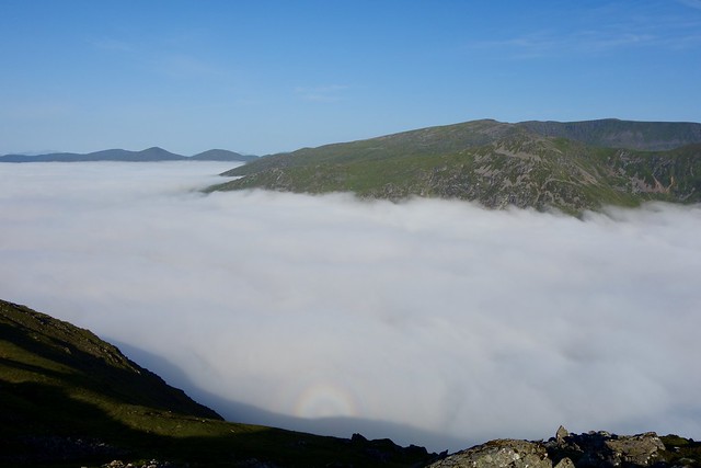
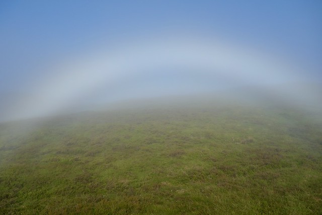
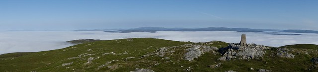
I was expecting the cloud to lift at the same altitude as it had been when I came off Leitreach, but I didn't break through the cloud til over 700m - a full 150m higher than just up the road. Weird. I did see fogbows, which I've only seen a couple of times before, as I made my way to the summit protuberance. I sat at the top, at 8.30, having my "second breakfast", not another soul anywhere in sight. Warm, but enough breeze to dispel midges looking out over an inversion - it doesn't get much better than this. Im not one for hanging about at summits, normally, but I did spend about half an hour sitting enjoying this one. Then back down into the cloud, boots soaked with condensation, spirits soaring after a fine weekend.
Fogbow (or a white Rainbow to those of you with a knowledge of Coil)
 AF4B0E31-EE1B-4C44-9102-3AB8D7A67BE1_1_201_a
 by
Al, on Flickr
 912B2F07-6D8D-4668-B2EE-D7AFC276D66C_1_201_a
 by
Al, on Flickr
 53BFA5DA-D6F7-4306-B61F-50A2F94692FC
 by
Al, on Flickr
 CBAE182A-347B-4C7E-9B20-90F758FAB6CF_1_201_a
 by
Al, on Flickr
 AB734619-843C-47C2-918D-F3EBB0907BB8_1_201_a
 by
Al, on Flickr
 A932049F-86AD-481D-8B4A-901907260355_1_201_a
 by
Al, on Flickr
 D98BECDF-620B-4585-9861-2614F9ECC46F_1_201_a
 by
Al, on Flickr
 1A48650C-7DBE-4ADC-BED2-C1CA4D1E4AE7_1_100_o
 by
Al, on Flickr
.
