free to be able to rate and comment on reports (as well as access 1:25000 mapping).
Wed 01 Sep – Sun 12 Sep, 2021OK, I admit that my main goal during this trip was to avoid the creepy crawlies, namely, the vile keds. There’d been a thread about them on WH, and….ugh. The memory of being besieged by them on Meall Doire Faid last year around this time…ugh. I pored over that thread, and a few recent walk reports, and learned that they’d been reported as out in force in the far north, Kintail, and along the west coast. I’d come to the conclusion, based on absolutely no scientific evidence, that they’d perhaps be less inclined to hang around the Moray coast—especially outwith the (Culbin) forest—and the high Cairngorm plateau. So them’s where I went. Ben Loyal, Baosbheinn, Beinn Bhreac, and other hills on the wish-list would need to wait, either until next year, or at least until we’ve had a few hard frosts. Bring on (proper) autumn!!
Thurs 02 Sep
Munro: Ben MacDui (+ Carn Etchachan, which *should* be a Munro)
7¾ hrs / 21.56km / 1176mI wasn’t sure where I was headed, exactly, except I had a vague notion to both revisit the magical waterfall that Evie and I had “discovered” a few weeks ago, and also to climb Carn Etchachan; I was mostly playing it by ear.

the cloud broke just at the ski centre; across to Meall a'Buachille
hello, Fiacaill Ridge. I shall never tire of looking at you!
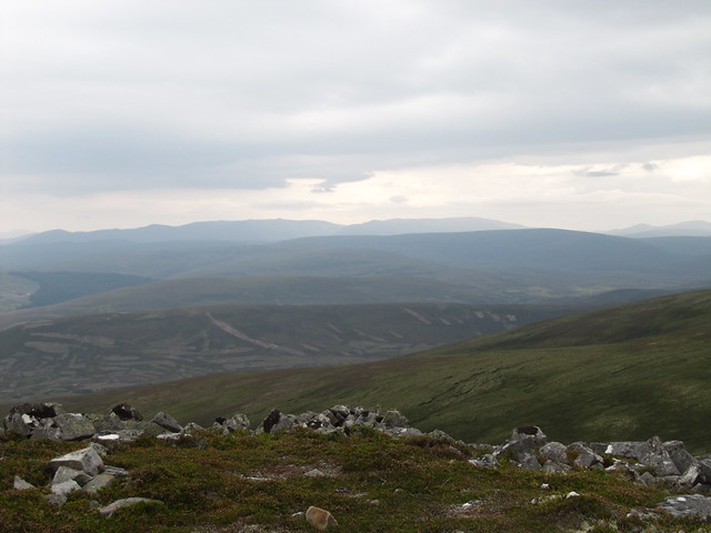
I climbed up to the 1141m point from the ski centre, which took me about an hour. From there, I started wandering in the general direction of Loch Avon. I descended steeply down toward a burn, thinking that it was the one on which THE waterfall was based. I picked up a path quite near the water, and it suddenly dawned on me (doh!) that I was in Coire Domhain, slightly east of where I needed to be. There wasn’t a breath breeze in the coire, and it was hot; before long, The Midge was upon me. I scurried back up toward the plateau, wanting to stay high, and hopefully in a breeze. From this point, I then recognized where I was, and followed the next stream over down to where I wanted to be. I wasn’t ready for a paddle or a swim; it was still early, and I thought I’d just nip on over to Carn Etchachan, and perhaps return this way later in the day.

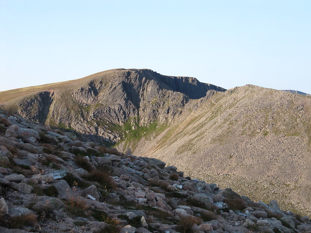
across to Carn Etchachan (foreground); Derry Cairngorm (I think), behind

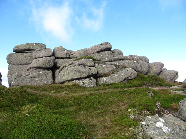
Shelter Stone crag

looking straight across into Hell's Lum, which was very impressive

Loch Avon looking down Castlegates Gully
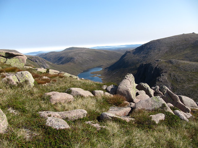
Loch Avon and Beinn Mheadhoin, from just below summit of Carn Etchachan

Loch Etchachan
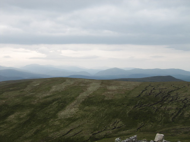
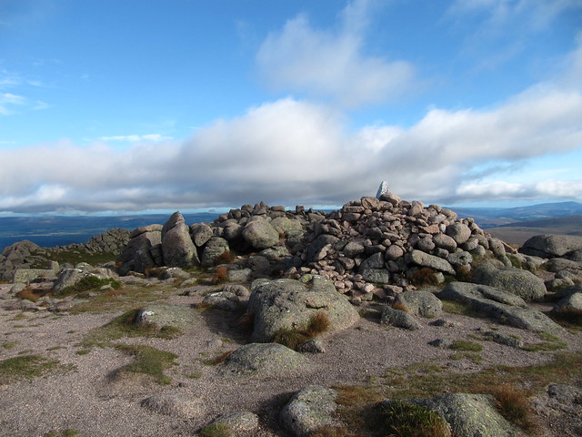
But I did end up going over MacDui, which was a zoo-ey, with people standing on the trig point, people waiting to stand on the trig point, and parties tucked behind nearly every cairn and structure. Yikes! I’d have been happier and enjoyed a bit more solitude had I returned the way I’d come. I didn’t bother standing in the queue, and just scurried on my way.
The path down from the summit wasn’t too terribly busy, and most people headed off toward Cairn Gorm, whilst I was heading directly back down to the ski centre. All in all, a(nother) good Cairngorm wander.
Fri 03 Sep
Nairn west beach – dip and walk
2½ hrs / 8.74km / 33m Sat 04 Sep
Slochd wander
3 hrs / 11.6km / 410mI’d been headed for the Cromdale Grahams, but somehow, I seemed to (far too) easily talk myself out of it. The forecast, although nearly universally predicting settled and warm, also warned of many tops staying in the cloud for much of the day. I didn’t want a trudge in the clag. I was also a bit worried about grouse shooting, as I know that the area I’ve walked before boasts many grouse butts. And it was just kinda nice hanging out in the kitchen for the morning, with my landlords away for the weekend.
But I needed to do something, and I decided to finally explore the area around the Slochd summit, to the northeast of the A9—there’s a gate onto the moor just at the summit, with enough room for one car to park; I think about walking up that track every time I drive by it. Today, I walked through that gate and up the hill.

It’s quite desolate, as I’d imagined. Although there is a lot of evidence of heavy grouse management; the tracks, grouse butts, previously burned heather stalks, and lunch shelters.

lunch shelter, looking back down the way I've come up
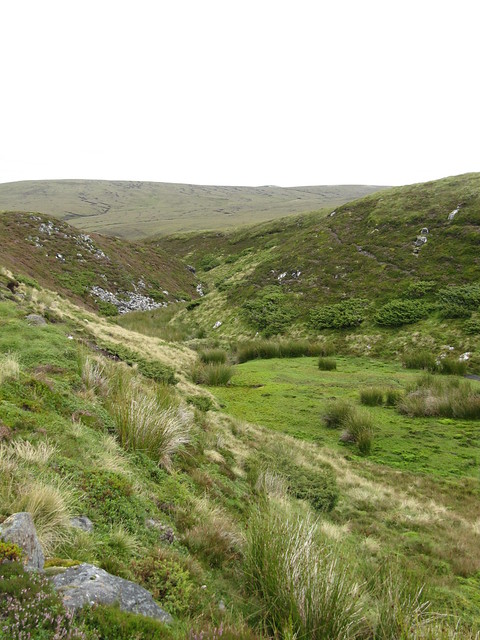
a bit of a gully-type feature

nice clump of bloomin' heather

looking down on the A9 / Findhorn bridge
I followed tracks for much of my outing, although as I neared the top of Gleann Mor, I realized that the track I was marching along would eventually take me far far from where the car was parked. So I heather-bashed for nearly 2km to pick up a track near the Allt na Feithe Sheilich, which would eventually lead me back to the track I’d rode in on.
Sun 15 Sep
Grahams: Carn a’ Ghille Chearr, Creagan a’Chaise
5 hrs / 20km / 726m Another Cairngorm wander. Although these hills had been on the periphery of my radar ever since I’d done a recce on them a couple of years ago when I spent a couple of weeks in Aviemore, I couldn’t get too excited about them. Because it’s been so dry, and because these hills have a reputation of bog, Evie had suggested them a few weeks ago; I think we ended up going to the high Cairngorms instead, or maybe that’s when we went over to Deeside. Anyway, since there’s been very little, if any, rain in the interim, it seemed like it still might be a good time for a visit.

hazy morning
I followed RH’s route, from just a few weeks ago, parking up earlyish (7:45am) at Wester Rynballoch. I did Carn a’Ghille Chearr first, and it was a looooooong way out to its summit. I was certain I was nearly there when I reached Carn Eachie, only to see the trig point at least another km in the distance. But I’d made pretty good time nonetheless, reaching it 1½ hrs after setting off.

still a fair ol' distance to Carn a'Ghille Chearr!

but I made it there eventually (Ben Rinnes behind me)
I didn’t stick around, as I didn’t really yet need any food or water. What had started out as a bright and sunny morning had become quite cloudy and dull; the hills in the distance now hazy.

on my way to Creagan a’Chaise; I like it when there's a good path!


the hazy blues, greys, and greens of t'other side

zoom to Glenlivet (I think) distillery
The view down to “t’other” side—Strathavon—and the view across to the Ladder Hills (and others) made me think about the week+ I’d spent in Tomintoul a few years ago. I liked the area; it still conjures (misguided, I’m sure) romantic fantasies of smuggling and illicit whisky stills.
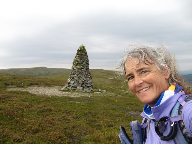
me and the coronation cairn
Once I’d passed the point where I’d ascended, it didn’t seem very far to the coronation cairn, and from there, the route to the summit was clear. What was a bit weird were the sections of very good path interspersed with boggy muddy pathless sections. These hills must be wet ALL the time, if they’re still this boggy after weeks and weeks of no rain. I reached my second summit at 11:15am (two hours after leaving the first summit), and sat enjoying the view over the northern high Cairngorms while eating my sandwich.

approaching the summit Creagan a’Chaise
toward Ben Avon...
...and northern Cairngorms

one more....looking a bit stormy, tho it came to nowt
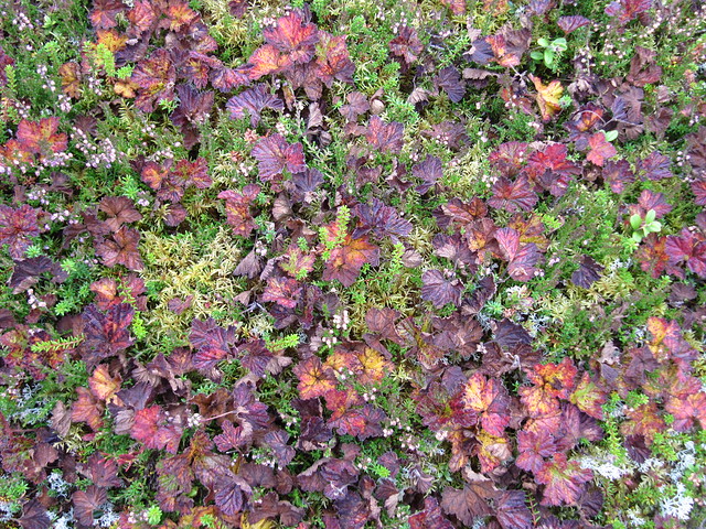
not sure what this plant it, but it's very colourful at the present

Piper's Stone
I’d seen no one to this point, but between the summit and returning to the track below the coronation cairn, I passed at least ten people; must be a popular Sunday stroll! I returned to the car at 12:45pm, exactly five hours after setting off. It had been an enjoyable outing, although the mind boggles at what the terrain must be like after a prolonged rainy spell! I can’t imagine that this route would be a viable option for a wet, and/or claggy day.
Mon 06 Sep
Findhorn Explorer
3 hrs / 11.34km / 59mWith all the coastal exploring I’ve done whilst staying in Inverness, I’d not yet made it to Findhorn, so it was well past time. I parked in the West Beach car park, and had a long walk along the beach toward Burghead. I returned to the village via the Moray Coastal Trail, hatching plans along the way about doing the entire MCT in sections, using public transportation. We’ll see.


Findhorn itself is actually a village, with a shop, accommodation, and several eateries. I’d somehow thought that it consisted only of the Foundation/Community, which, ironically, I ended up missing entirely, in spite of looking for it. Doh. I’d headed toward what looked like some “eco” wooden buildings on my way back, only to find that they were self-catering lodges, interspersed with caravan/campervan pitches—dozens and dozens of them. (It ended up that I was actually sort of on the right track, as looking at the map and website later, the Foundation shares their location with the holiday park. I’m not sure whether they’re associated or not. More info and/or another visit required.)

across the bay to Culbin Forest

the swirling currents

Anyway, I wandered through the village, looking for fish and chips (it was one of those days when I couldn’t seem to stop eating), but it was still only about 11:30, and the van I’d decided to get them from didn’t open until noon. So I wandered out to the mouth of the channel—it was high tide—and marvelled at the swirling and wavy currents. And enjoyed the view over to the Culbin Forest, which looked close enough to reach out and touch.
I purchased the most excellent fish supper (to rival the Seaforth, in Ullapool!) from the van, and scoffed the lot, sitting by the water in the warm, but not too hot, sunshine. Nice!
I drove into and wandered around Forres on the way back; it’s a nice wee village, with some impressive floral displays at the moment. I ruined the drive home by stopping at Brodie Country Fare (why, oh why did I do this? Hordes of people everywhere, and I didn’t see anything I needed/wanted to buy – as per usual – I love the idea of farm shops, food halls, House of Bruar, etc., but usually get quickly overwhelmed). I avoided Nairn by going through Auldearn instead.
Tues 07 Sep
Munro: Bynack More (Explorer)
6½ hrs / 24.75km / 962mThe Cairngorm theme continues. I made an early start, figuring this hill would be busy, even mid-week. Aren’t all the kids back in school? The Highlands are still heaving! I parked up legitimately at Glenmore, in the area where there’s room for a half dozen cars or so; much of the single-track road in from the Reindeer Center is coned off. I was the first one there—which was SO not the case on my return!


I marched quickly up the familiar path. Stopped to take the obligatory photo of Lochan Uaine, then carried on to where the path splits, one way leading to the Ryvoan bothy, the other going “my” way.
I was going to stop for a quick breather at the bridge / Bynack Stable, but I rounded the corner to find an entire small industrial site! A large tent, several vehicles, and a digger. Two people having their breakfast outside the tent. I simply said “good morning” and carried on. (I stopped for a chat on the way back, to ask about what they were doing, when I’d spied three additional diggers, plus a variety of other “stuff” high on the hillside. They’re cutting heather, and collecting seeds to be transported higher up the plateau—basically, a(nother) method of peatland restoration.)


morning light on Strath Nethy

The path ascended gently up the side of the hill; it went on for longer than I remembered, but I slowed my pace, concentrated on my breathing, and stopped occasionally to see if anyone was behind me—to my surprise, there was no one, and I thought I just might have the summit to myself for a bit.
I’m quite sure the path has been upgraded since my last visit (in 2014). Even on the steepest bit, there are only a few short sections that are somewhat eroded.

to the NE (??), Ben Rinnes
The last time, I stayed on the east side of the ridge, advised to do so from someone who seemed to know what he was talking about, because the wind was very strong; I hadn’t hung about then! This time, I crossed over to the west, and approached the summit from that side instead.
up the west side, summit ridge above me
summit cairn
I’d not been at the top for more than three minutes before I was joined by a lad who’d made very quick work of the ascent. So much for solitude! But we had a nice chat; he’s a med student on a placement at Raigmore; who, like me, has gained an appreciation for how convenient Inverness is for getting to so many hills.
I was off then to do some exploring. The barns, big and small; A’Choinneach—which apparently used to be a Munro—and beyond its summit to the point where Loch Avon came into view; back to Bynack Beg.


this curious seam made me wonder what different was going on for those hundreds (thousands?) of years...

looking across to where I'd been a few days ago

near the summit of A’Choinneach

Loch Avon just coming into sight (from the "other" end)

summit Bynack Beag

both Bynacks (Beag and More)
I’d seriously contemplated returning via Strath Nethy, which has a reputation as a right bog feast [sic]. As dry as it’s been lately, now would be as good a time as any. But it was another very warm day, and it seemed likely that there’d be little or no breeze down in the glen. I chose to stay high rather than chance a very long, probably hot, possibly midge-ful and potentially miserable return journey.
The way back from Bynack Stable seemed much longer than it had in the morning.
Wed 08 SepIt was gonna be hot, hot, hot. And I was tired, tired, tired. So I managed to do a whole lotta nuffin, nuffin, nuffin—and didn’t even feel (particularly) guilty about it.
Thurs 09 Sep
Nairn west beach
3 hrs / 12.4km / 26mThe weather changed drastically overnight; much cooler, low cloud, and drizzle. But I needed some exercise, so I headed early to the beach, to have a long walk and perhaps a plunge. The walk happened; the plunge did not. A persistent “mizzle” ensured that I was cold and soaked by the time I returned to the car, so perhaps I should have gone in anyway—it probably would have made me only marginally colder and soaked-er. Home for a hot shower, laundry, reading, and other catchup chores.
Fri 10 Sep
Fyrish Monument
1½ hrs / 6.1km / 277mI was at a bit of a loss as to what to do today—the forecast—esp for the hills—was once again not very good, although I daresay that it ended up not being as wet as I thought it’d be. I’d considered and rejected various outings, but had itchy feet, and just needed to get out and do something. So I headed for the Black Isle, wanting to find my way to the Cromarty Brewery to pick up some Happy Chappy, which was the beer I’d had (and liked, obviously) on the day we’d gotten caught out by the tide.
You’d think the place would be fairly easy to navigate. Once I’d found my way to the brewery (via Cromarty, because I’d missed the turn for Davidston), all I wanted was an easy way to return to the A9 without going back through Fortrose and Rosemarkie. Well, there doesn’t seem to be one. I’d wanted to explore the Black Isle more anyway, but I’d have preferred to do it when I wasn’t driving in pea soup!
After driving well out of my way—I’d been told to “make a left at the T-junction,” which I never came to—I finally ended up at the turnoff for Findon, just to the south of the Cromarty Firth crossing.
The Fyrish Monument above Alness had been one of the walks I’d read about the night before. I knew it wasn’t very long, but at least it’d be something. And the monument looked quite impressive from the photos I’d seen. The fog had perhaps lifted slightly (wishful thinking?), and although I figured that a nice view over the Cromarty Firth was unlikely, I did think that there might be an inversion (more wishful thinking).
There’s a clear well-made path all the way to the monument. It was actually a steeper climb than I’d envisaged, but the entire outing still only took an hour and a half. I didn’t stick around at the top but for to take a few photos; the mist hadn’t cleared, and there wasn’t much else to see.

marching orders

misty through the forest
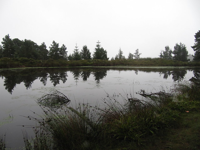
the wee lochan

 Sat 11 – Sun 12 Sep
Sat – rain, rain, rain. Tidied my space, packed a few things, and did not much else. I left for home at first light (6:30, not so very early any more) on Sun morning—proving more and more a definite sweet spot for making the journey.
