free to be able to rate and comment on reports (as well as access 1:25000 mapping).
Was it really just a week ago that we had great weather and could enjoy life to the max? Normal service returns this week with wind, rain and clag. Didn't look an inspiring forecast for doing anything interesting, so we cut our losses and did some more prep for our planned CWT walk in May. Although, given the apparently inevitable march towards WWIII we might be fortunate to get the CWT done before the holocaust of nuclear annihilation wipes us out. Cheery thought for the day...
I decided we'd head up to Comrie Croft for a couple of nights, do Meall Dearg - a somewhat featureless bump north of Amulree - on Friday then do the Shee of Ardtalnaig and Creag Uchdag from the Sma' Glen. Allison hadn't been up there and it would mean a longish walk to improve fitness with big packs on rather than the shorter approach from the south bank of Loch Tay.
We didn't see any other tents as we arrived at Comrie Croft, still in the light at 6.20pm. A windy and rainy night ensued. I was feeling crap on Friday due to a headache/nausea and grimly drove along the road to Amulree. It was claggy and wet. We parked at the community centre and set off along one of the many farm related tracks in the area. I wasn't really paying full attention, for we headed uphill too early, heading up Creag Hulich rather than continuing further NE and walking up Glen Fender. It didn't matter a great deal - probably added a couple of kilometres and two hundred metres extra ascent. But don't follow my route - unless you want to!
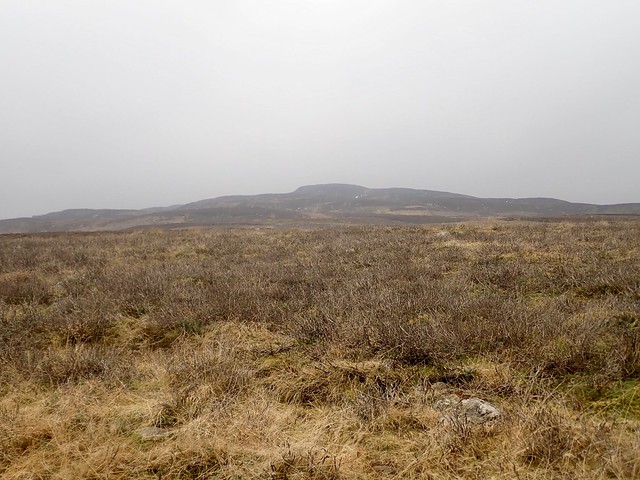
There was nothing to see, and we were on gravel track, presumably gross-butt related. We took a couple of right turns and met up with the track we should have followed as it climbed up Beinn Liath. We continued on the track until we were nearly at Meall Dearg, when we had to cut up left into boggy ground and make for the summit trig. I did notice that someone has been cutting down all the self-planted fir trees around here - not seen that before. They probably interfere with shooting grouse in some way.
 337F7D5C-152B-453D-A80F-B4C022D0F9AB_1_201_a
 by
Al, on Flickr
We returned to the track and continued north for a short way before descending and heading to the SE along one of General Wade's many roads. It's being widened by diggers? wind farm related? Anyway it was very muddy. Lots of snap - traps along here. We crossed over the road and continued on rough track for another short period. Six fox snares set here. It's one of the things I hate most about walking in Perthshire - the extent of animal persecution that goes on. I noted when walking up the Sma' Glen that none of the (many) cattle grids had the little animal ladders to help creatures that fall into them get out. I think Perthshire's one of the worst parts of Scotland in terms of how aggressively wildlife is dealt with.
Meall Dearg
 1D910672-CA7C-4A3A-AEAB-7E69C9B300DC_1_201_a
 by
Al, on Flickr
 6E8D21D5-2227-4FBA-A5FA-E80D061EC107
 by
Al, on Flickr
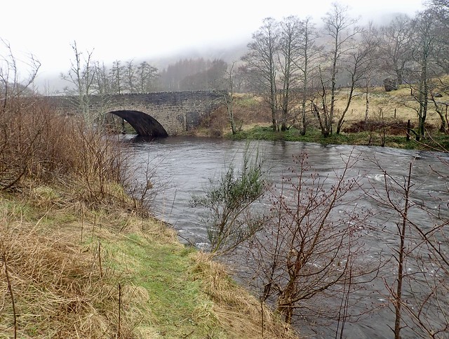
By this time we got back to the car I was feeling a good deal better and was able to manage a spicy stir fry when we got back to the tent. Another night of heavy rain. We watched some videos of folk doing the CWT, paying particular attention to kit recommendations. We got up none too early on Saturday morning, packed up our soggy things (giving thanks that the rain had temporarily abated while we did so), parked the big rucksacks and set off back along the Amulree road making for the parking at Newton Bridge. We had been following a white car with an older man wearing Paramo, who also pulled in to the parking area.
I'd been up the Sma' Glen last year doing Auhnafree Hill and some Simms, and had quite enjoyed the walk. We'd get less chance to enjoy the craggy sides today thanks to the clag, but it's a good walking surface. And it was quite busy with cars and tractors. After a few km the older man from the white car passed us on a bike (electric). We said hello, then I called after him which hills was he doing? He stopped and said two names I didn't recognise, and it occurred to me that he must be a bagger. Indeed he was - Relative Hills royalty as it turned out. He was on his way to do A'Chairidh and Biorach a'Mheannain, a couple of Simms off Auchnafree/Chonzie, that I'd done last year. He talked about Alan Dawson's new book and it turned out that he was one of only two people to complete the HuMPs - on the Old Man Of Hoy with Rob Woodall in 2018. He introduced himself as Alan Whatley, a name I'd been familiar with from Hill-Bagging. We spoke for a while, we said we were planning the CWT soon and he told us he'd done that some years ago, but starting at Duncansby Head, continuing on down the WHW and ending up at Land's End all in 147 unsupported days. I didn't really know what to say to that

Newton Bridge
 B53F2104-CA4C-41A8-A4EE-CEDCD62B086E_1_201_a
 by
Al, on Flickr
 023212BE-0B53-4397-B836-66083628850E_1_201_a
 by
Al, on Flickr
 08F48AAB-DFCF-4B3A-8DB6-E524A16797AF_1_201_a
 by
Al, on Flickr
 65325FD4-37D8-4102-8D3E-ED1A27040BDB_1_201_a
 by
Al, on Flickr
Alan headed off for his hills and we continued on our way up the glen. Frogs were busy spawning and we saw a couple of little newts on the road. We paused for lunch about 12k in, behind a mound to shelter from the sharp wind. Then on past the dam, the track becoming ever more flooded as streams in spate ran down the hillside. One of these was so deep looking and fast flowing that we tracked a way upstream to see if it was any easier to cross but it wasn't - we just had to wade. We were nearing the boarded up farm house at Dunan by this time, which sits at the foot of The Shee. We looked around for a place to pitch the tent that would be sheltered from the wind (set to increase substantially overnight) and ended up inside the stone walls of a sheep fank. We pitched and dumped our stuff, setting off up the nose of The Shee. Deer tracks made this a little easier - it was very blowy from the west, especially when we got near the summit.
 D0ED0352-8554-447A-848D-2370A1E5F8C4_1_201_a
 by
Al, on Flickr
 A75CD214-1DE3-4A09-AD5C-7AA236CF1421_1_201_a
 by
Al, on Flickr
 48678A23-88FE-49F8-9499-0912B2FE67B8_1_201_a
 by
Al, on Flickr
The Shee
 F7CBFC1B-EE3B-4AEC-8740-6DD1547645E3_1_201_a
 by
Al, on Flickr
 AA80C7C1-3C16-4C34-A7F8-9EC2C51318AD_1_201_a
 by
Al, on Flickr
 AB0B6A56-D5C4-4E09-8F8D-5583A90E3268_1_201_a
 by
Al, on Flickr
I was swithering about doing Creag Uchdag - I felt quite tired and I knew Allison did too. I could leave it for Sunday morning - but I knew if I did that I'd never get it done. I was concerned about having to cross rivers, given the in spate nature of them, but I looked at the map and reckoned I could take the track up and only have a smallish stream to cross. Go for it! I suggested to A that she head back to the tent and get it set up - I thought I'd be a couple of hours.
I headed straight down from the Shee to the new gravel track that goes past the farm house and continues for 2-3km up by the Allt a'Charran, replacing the footpath marked on the map. Sadly it comes to an end being replaced in turn by a very wet ATV track that heads for the bealach between Uchdag and Oighreag. I followed this for a while, then turned up by the Allt nan Eun Shuas, dodging the odd patch of snow making for the visible trig column on Uchdag. The weather was much improved by now, the rain having ceased and the sun even being visible across the hills. I noted someone else had been at the summit of Uchdag today from the footprints in the snow. The walk back down was very enjoyable, all down hill. The Corbett had taken me two and a quarter hours, not too bad for 9k after a longish walk in.
 D0B81795-63DC-454A-B0F0-A78BDAD4D038_1_201_a
 by
Al, on Flickr
Loch Turret
 7C6A6CBC-312D-4B1F-A9D0-9BD1A4C1604A_1_201_a
 by
Al, on Flickr
 2FC5CC72-0B0F-4D44-9495-0CDE52720818_1_201_a
 by
Al, on Flickr
 CF91982E-E36D-47CC-B42C-FEB0D8498B44_1_201_a
 by
Al, on Flickr
 6C02B54A-8BC2-4F8B-BE86-FFF690A62A48_1_201_a
 by
Al, on Flickr
We feasted on Huel and tent biscuits then read a bit before heading to sleep - although the rain had re-started and did its best to keep us awake. The forecast had been for heavy snow overnight, but there was only heavy rain - indeed there was less snow on the hills in the morning than there had been the night before. It was wet and foggy when we set off back down the glen, the stream crossings on the path being even more overflowing than on the day before. Still, the rain did go off for periods, giving our gloves and clothes a chance to dry a little before they got soaked again.
 F4A433EC-366D-41D9-9423-F2889A618328_1_201_a
 by
Al, on Flickr
 6B1C8C6A-F210-4754-B9C7-5F1B77120608
 by
Al, on Flickr
Morning Clag
 E19D434F-3928-4A20-9005-283C72033F4D_1_201_a
 by
Al, on Flickr
Due to GPS malfunction the stats are 13km and 150m ascent short
 FD8DA3DA-3816-44DC-B225-D41D3B4B936F
 by
Al, on Flickr
So not the most exciting weekend, especially when compared with our last outing, but rough with the smooth and all that. 70k more fitness practice in.
