free to be able to rate and comment on reports (as well as access 1:25000 mapping).
I should probably say before I start, as this is my first walk report, that I count myself as a very keen scrambler, but that my experience lags behind my excitement. I have managed the Aonach Eagach, but only thanks to some encouragment by fellow walkers. Thank you, if you're reading this.
I must also quickly mention the rather wonderful board outside the Sligachan hotel - one of those with a line drawing of the horizon and the names of all the peaks. It really is an invaluable guide to the newcomer who wants to be able to orient him/herself quickly before setting off. I never had any doubt where I was heading for after looking at this.
So having arrived at the Sligachan campsite (which is where I hope the OS references I've submitted start from) at about midday today I decided to have a "swift trek up onto the moor to get the lie of the land". Oh how we kid ourselves. I had a fully-packed rucksack, it had been almost a week since my last climb, and mountain fever took over. I'd been reading up on the Am Basteir route in the Cicerone 'The Isle Of Skye' guide, so that must have been what caused me to cross the first bridge, following the excellent footpath, and then not cross the second bridge and keep following the excellent footpath up the banks of the Allt Dearg Beag towards the Basteir gorge. There's really little to say about this section of the walk except that the path passes near to some very pretty waterfalls and waterslides, and that as you approach the gorge and the cliffs of Sgurr nan Gillean start to loom ominously ahead a sense of impending doom starts to take over.
There is obviously no way through the Basteir gorge. It had been raining for most of yesterday and the roar of the river was enough to keep me well away from the edge as the path climbed up scree and over slabs on the eastern flanks of Sgurr a Bhasteir. It was hard to follow the path at this point, what little of it there was, but the objective - Bealach a Bhasteir - was obvious all the way as the low point between Sgurr nan Gillean and Am Basteir. Once in the corrie the route was pretty obvious and I gained the Bealach without much trouble at all. Without pausing for thought I turned right and scampered up the ridge towards the summit.
Perhaps some thought would have been useful. The guidebooks refer to 'an awkward descent on the ascent', and this website refers to a route that would avoid this completely. Me, I hit it head on. You see, I love a scramble and if there's a ridge I love to scramble right on the crest of it. After all, I'm sure we all agree, there's nothing like it is there? The drops on both sides, that feeling of being on top the world, it's exhilarating to the point of addiction. And I am addicted. "Where is this tricky bit?" I kept asking as I trotted carefree along the crest of the rather exposed ridge, loving every minute.
"Ah, here it is." I finally found myself saying, as I was stopped dead in my tracks by what is basically a 4 meter vertical slab of rock that must be descended with huge exposure on both sides and, to my eyes at this point, no visible holds. I spent some time studying it, eyeing it up, and drinking water, but the combination of the very strong winds, low level cloud, and my own internal warning systems going into overdrive made me back off. To be honest the wind and cloud were an excuse, I wouldn't have gone down there on my own if there had been a pot of gold at the bottom of it. Fortunately below it and to the left I could see some vaguely horizontal ledges that, if reached, could be used to bypass this obstacle completely. I backtracked quite some way and eventually attained the ledges, passed the slab, and made the summit. I'm pretty sure these ledges are the route described on this website... I'm just a ridge addict and ignored all that

The only way down from the summit without ropes is back the way you came up. On the way down I encountered the slab again and, while one half of my brain invented justifications for avoiding it again, the other half took over, found hand and footholds and did manage to scale it without too much trouble. And now I've done it and I know where the footholds are it's not as hard as it looks. If went back again I'd give it a shot on the way up, but it would still require brown trousers. As is so often the case with a scramble, the exposure if half the battle, and this is very exposed and therefore pretty darn scary.
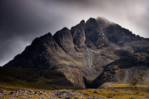
Anyway, returning to the bealach and descending the scree a little it is possible to traverse under the base of the cliffs of Am Basteir and gain the ridge between the Bhasteir tooth and Sgurr a Bhasteir, from where it's a simple walk to the top of Sgurr a Bhasteir. The reason for doing this, apart from a love of muscle pain, is for the unequalled views of Sgurr nan Gillean's pinnacle ridge and of the Bhasteir tooth. Well worth it if the light's good and you have a camera. I had a camera, but it the cloud chose that moment to encase me in its whiteness. I got one shot.
![DSC_7390-DSC_7392.jpg]()
As far as descending from Sgurr a Bhasteir goes, I don't know what the normal route is but I would hazard a guess that it's not the route I chose. The Harvey's map showed a nice scree slope that descended between two crags in a northerly direction and which would allow me to eventually join up with the path by the Allt Dearg Beag. The reality of this was a revoltingly slippery slope of mixed scree and rocks, which descended towards crags with a very steep drop in between them. I ended up traversing the scree in a roughly westerly direction and then descending NE once the gradient levelled off. I would reckon the best descent would be to stick to the ridge until it levels off and then descend NE back towards the path up.
I've never been great at descents, but as ascents go this one's a corker if you like a good scramble. The continuation to Sgurr a Bhasteir makes it a decent length walk and provides wonderful views. N.B. My submitted route terminates at the pub. You know it makes sense
