free to be able to rate and comment on reports (as well as access 1:25000 mapping).
Classified Hills: Meall na Suiramach (Marilyn, HuMP), Bioda Buidhe (Marilyn, HuMP), Beinn Edra (HuMP), Creag a'Lain (HuMP), Baca Ruadh (HuMP), Hartaval (Graham, Marilyn, HuMP), The Storr (Graham, Marilyn HuMP), Ben Dearg (Marilyn, HuMP)
Date: Tuesday 27th March 2012 and Wednesday 28th March 2012
Company: Just myself
Distance: 36.1km (Day One 24.7km, Day Two 11.4km)
Ascent: 2400m (Day One 1850m, Day Two 550m)
Time: 15Hrs (Day One 10Hrs, Day Two 5Hrs)Click here to see a map of the route undertaken on Day OneClick here to see a map of the route undertaken on Day TwoA traverse of the Trotternish Ridge has been on my wish-list for a number of years. However, when the weather has been good I have always headed for the Cuillin. An old sage of the hills once said to me, “North Skye is not Sgurr nan Gillean.” It was time to put things right and do justice to North Skye.
In planning for the traverse, I knew several factors had to be right: a) good weather, b) pre-midge and c) being fit. It was certainly debatable whether or not I was fit enough, however, what I lack in fitness is made up for with stubbornness and determination. Planning for the traverse also involved the debate – one long day going light or two easier days with a heavy pack. I opted for the two-day approach, as I quite fancied camping out on the ridge.
Very early on Tuesday morning, I drove to the Quiraing car park - at the high-point on the road from Brogaig to Uig. I then ascended a short distance up Bioda Buidhe where I stashed all my camping gear and three litres of water. I then drove to the start of the Trotternish Traverse, at Flodigarry. This allowed me to undertake the initial section with a light-pack, carrying little more than 1.5 litres of water.
I parked just off the main road beside the Flodigarry Hotel.
I set off walking along the A855 just before dawn. On reaching the start of the Quiraing track, beside Loch Langaig, I witnessed a lovely sunrise. Perfect blue-skies except for some smoke from nearby heather burning.
Sunrise at Flodigarry:

Skyecomuseum sign near start of Quiraing track:

I then made my way along the track towards the Quiraing. The Quiraing section was my favourite part of the whole traverse so I took, and have included, a good number of photos.
First light on the Quiraing:

The track/path up to the ridge is pretty-good – probably the best section of path on the whole Trotternish ridge.
Following the Quiraing track:

The Quiraing are worth a visit, even if you’re not contemplating a traverse.
Quiraing:

Pinnacles:

On reaching the section of path immediately below the cliff, I could see Srón Vourlinn in the distance. I was keen to start the traverse of the ridge from Srón Vourlinn.
Following the track below the cliff (Srón Vourlinn in distance):

Ascending towards the ridge and Srón Vourlinn:

The views on gaining the ridge were really special. To my friends who only “bag” Munros, check this out for breath-taking scenery.
Quiraing from the Trotternish Ridge:

On reaching Srón Vourlinn, I stood at its high-point – which is quite airy! I then set off along the long traverse of the Trotternish ridge.
View from the top of Srón Vourlinn:

Looking back to Srón Vourlinn:

The geology of North Skye is incredible.
Courtesy of Scottish Geology,
“The rocks at Trotternish consist of Jurassic sedimentary sequences overlain by thick Palaeogene lava flows. Dolerite sills and dykes intrude the Jurassic rocks. All the rocks dip gently to the west, creating slopes rising gently across Trotternish peninsula from west to east, with steep scarp slopes on its eastern margin. N-S trending faults are also developed along the peninsula. The slides formed due to the overlying weight of the lava flows (a total of 24 flows, approximately 300m thick), weighing down on the weaker Jurassic sedimentary rocks. Under the pressure, the Jurassic rocks sheared along the N-S faults and huge blocks slid seawards along a rotational glide plane.”Srón Vourlinn and Leac nan Fionn:

Srón Vourlinn and Leac nan Fionn:

As I made my way along the edge of the cliff towards Meall na Suiramach, I was so busy admiring the views that I overshot the summit by several hundred metres. This was soon put right. Meall na Suiramach, along with its Quiraing, is a fantastic Marilyn.
A long way to go along the Trotternish Ridge from summit of Meall na Suiramach:

From Meall na Suiramach, I made my way towards the Brogaig to Uig road, where I intended descending to its high-point. As I made my way down towards the road, I was seriously impressed with Cleat. Cleat is a really steep HuMP – I’m definitely coming back to climb it!
Cleat above Loch Cleat and Bioda Buidhe from Meall na Suiramach:

Steep descent from Meall na Suiramach down to the Brogaig to Uig road:

On reaching the road, I stopped for a wee rest before ascending Bioda Bhuidhe to where I had stashed my camping gear and water, a few hours previous.
The combined weight of my rucksack, camping gear, 4 litres of water, food, etc. was now circa 13kg. The first few hundred metres was a bit of a struggle, but I soon got used to the weight.
Looking back to the Quiraing from slopes of Bioda Buidhe:

View from Bioda Bhuidhe:

Cleat and Dun Dubh / Druim an Ruma:

On reaching the grassy featureless summit of Bioda Buidhe, I traversed to below the 452m top before descending to Bealach nan Coisichean. There is a large cliff directly to the South of Bioda Buidhe.
On reaching the bealach, I was a bit surprised to find the first of several burns on the ridge. On reading up about the Trotternish Traverse, I read that there is no water on the ridge – this advice is wrong, unless these burns sometimes run dry?
Looking along the Trotternish Ridge towards Beinn Edra:

From the bealach, Beinn Edra looked a long way off.
Wee pinnacles:

Looking back towards Bioda Buidhe with Quiraing now in the distance:

As I made my way along the ridge, I could see the Calmac ferry at Uig. This brought back some good memories of previous trips to Harris and North Uist.
Uig (full zoom):

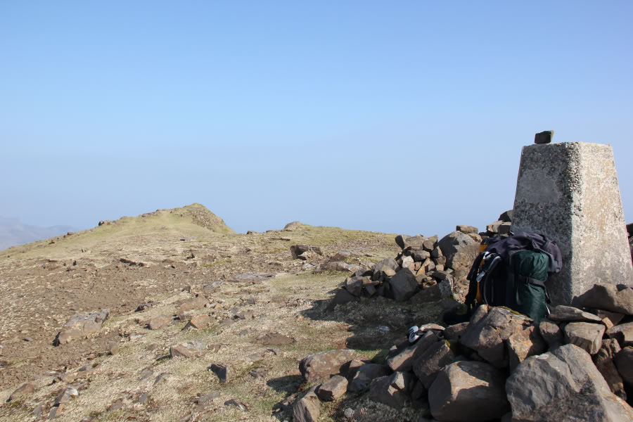
The ascent of Beinn Edra was quite arduous given the heavy pack and the heat. Was great to reach the summit trig point – my third HuMP, and first Graham-top, of the traverse.
Trig point at the summit of Beinn Edra:
The long section of ridge from Beinn Edra (Graham-top) to Hartaval (Graham), involves lots of ups and downs, including a further two HuMPs – Creag a’Lain and Baca Ruadh.
The following couple of photos show how pleasant the underfoot conditions are along this section of the ridge.
Looking back towards Beinn Edra:

Looking back towards Groba nan Each:

Looking towards Sgurr a’Mhadaidh Ruadh, Baca Ruadh and Creag a’Lain:

Was interesting to find a diagonal wall running across Creag a’Lain – it looked quite old.
Creag a’Lain:

Between Creag a’Lain and Baca Ruadh, there is an impressive spur called Sgurr a’Mhadaidh Ruadh.
Sgurr a’Mhadaidh Ruadh:

Much of the ridge consists of gentle grass slopes to the West and sheer cliffs to the East.
Steep drop:

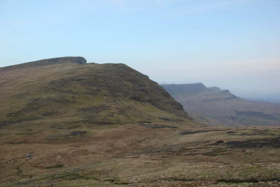
By the time I reached Baca Ruadh and its top Sgurr a’Mhalaidh, my eyes were streaming as the air was filled with smoke from heather burning. It was nice to see that the ascent of Hartaval was next.
I was in two minds about either camping before or after Hartaval. Given Bealach Hartaval was dense with smoke, coming up the glen with the River Romesdal, I opted to continue on and also ascend Hartaval.
Hartaval from Sgurr a’Mhalaidh:

Looking back to smoky Sgurr a’Mhalaidh and Baca Ruadh:

By the time I reached the summit of Hartaval, I was feeling tired and had aching shoulders. I had already ascended 1850m, so I decided to descend to the Bealach a’Chuirn, and set-up camp for the night.
Cairn at the summit of Hartaval:

I reached the bealach at around 17:00, ten hours after setting off.
Pitch at Bealach a’Chuirn:

I then had some dinner and got into my sleeping bag to keep warm, as it got quite chilly. I fell asleep around 21:00 and woke up at 01:00. On wakening, I decided to go out for a look at the stars. There were thousands if not tens of thousands of stars visible. There was also a very faint glow – aurora!
I switched the camera to manual, set it on the ground and took some long-exposure shots. I managed to get a couple showing the tent and the aurora.
Faint aurora from Bealach a’Chuirn at 01:20:

Faint aurora from Bealach a’Chuirn at 01:20:

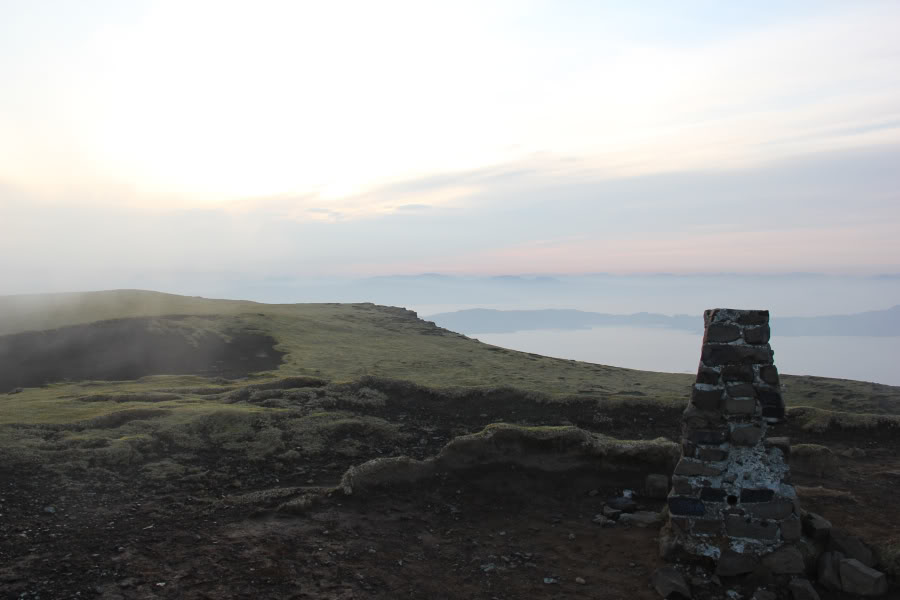
I then went back to bed and slept through to 06:30. By 07:20, I had packed up camp and set-off up The Storr. The ascent of The Storr was straight-forward.
Ascent of The Storr:

Looking back to Hartaval from The Storr:
During the ascent, I was really pleased to get my first glimpse of the Cuillin. Even better, there was inversion!
First glimpse of the Cuillin:

Red Cuillin:

Black Cuillin:

I took quite a number of photos at the summit of The Storr. It was great to see so many hills with inversion below.
View from summit of The Storr:
Inversion below Raasay and the Red and Black Cuillin:

However, the downside to the inversion was soon apparent as most of the remaining walk was in cloud. Need to take care to avoid the cliff edge if walking in clag.
A glimpse of pinnacles through the mist:

Somewhere between Bealach Beag and Bealach Mor, I stupidly dropped one of my walking poles. As there was no path and I was walking in cloud, I failed to find it on trying to retrace my steps. If anyone finds a Leki Makalu pole up there, I’d be grateful if they could please give me a shout.
The hardest part of the whole traverse was definitely the final 100m of ascent of Ben Dearg. It was certainly made more difficult by the fact that I could not see where I was going. I chose to follow a line of fence-posts, which thankfully got me to the top.
Final very steep ascent of Ben Dearg:

Summit of Ben Dearg:

The descent from Ben Dearg was unpleasant. Instead of nice short grass, it was mostly peat hags and bog. By the time I reached the bealach between Ben Dearg and A’Chorra-Bheinn, I decided to head for the road – giving A’Chorra-Bheinn and Pein a’Chleibh a miss, as many others have also done.
Hags and bog:
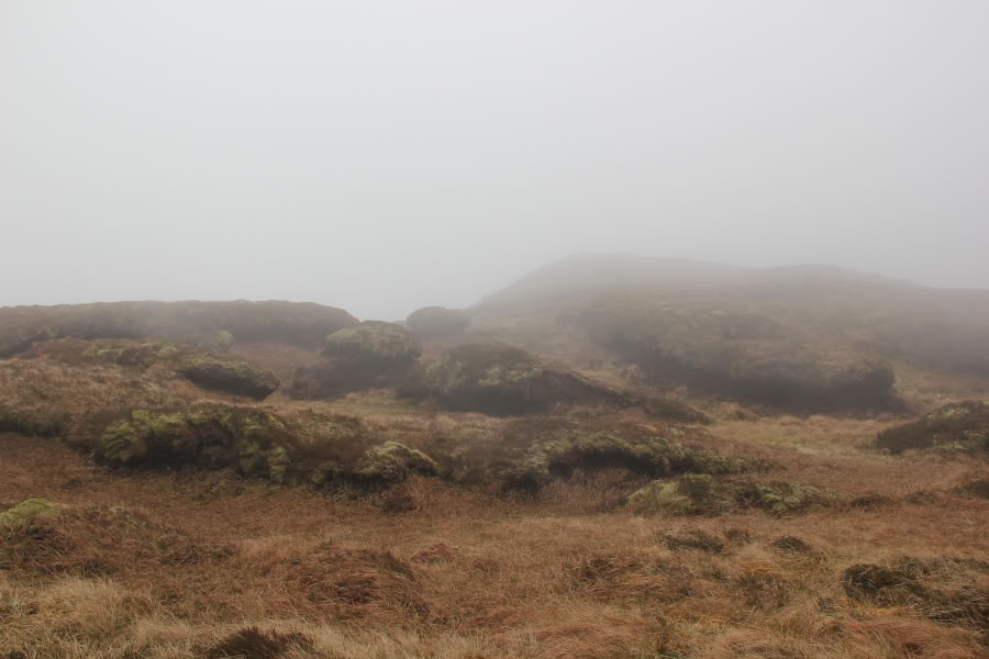
Looking back to A’Chorra-Bheinn:

I eventually met the road at the 158m high-point and then walked just over 1.5km to the Achachork junction.
I now had two choices – a) catch the next bus back to Flodigarry - which was due in 10 minutes or b) walk the final 1km into Portree, miss the bus and have to wait over three hours for the next one. I opted for a).
The End - A855 Achachork junction:

The Trotternish Ridge is quite fantastic - it is unlike any other hillwalking I have done in the UK. Highly recommended – but don’t underestimate the amount of ups and downs

.
