free to be able to rate and comment on reports (as well as access 1:25000 mapping).
Usually in a walk report I like to tell a bit of a story. I think that makes it fun and I like words. But in this case, I really just wanted to share my actual route with you all. This is the genuine route, as recorded by ViewRanger, that I took on this walk. I hope you'll all find it as amusing as I do.
And I guess there is a bit of a story behind it too, so I'll endeavour to tell it with the help of this small bottle of Talisker I have here.
Last year I set out to follow a walk in one of my guidebooks, called "The Eastern Mamores". This was supposed to take in 4 Munros, of which Sgurr Eilde Mor was the first. Those of you who know the area will doubtless know what the other three were. Those of you who don't won't mind if I don't tell you I'm sure. It's not very relevant. The relevant fact is that on that occasion I decided not to climb Sgurr Eilde Mor on account of the fact that it's a very long walk, that one, and I'm a big Jessie.
I did, however, spend a lot of time looking at Sgurr Eilde Mor that day and deciding that it was one of, if not the prettiest peak I'd ever seen. And I knew therefore that I had to come back and climb it one day. Pretty things are a bit of a magnet for me. And so I found myself in Glencoe, looking at a weather forecast which was for a lovely morning and a wet afternoon and thinking, "I could get up Sgurr Eilde Mor before it rains". Consequently I was parked up in Kinlochleven at 8:15am, which for me is the middle of the night.
One of the reasons I started recording the route on this walk is that I remember full well from last time getting very confused by the plethora of paths leading up from that car park. I've learned over the years that my inbuilt sense of direction only works on the way down. Even in complete whiteout I can find my way to the car without even thinking, but finding my way up - you might as well spin me round and ask me to pin the tail on the donkey when the donkey is in a different room. I made my first wrong turn after 10 yards, turning right when I should have gone left. But once I realised and backtracked, and missed another turn and backtracked again, things started to improve. For a while. I have to say, for all my old-fart-ish "I prefer a paper map and compass" (and I still do, I LOVE maps), at times like this I praise the engineers who had the lunatic idea of putting up satellites to tell us where we are.
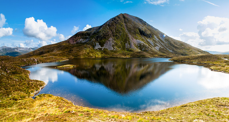
It's something of a slog up through the birch woods out of Kinlochleven and even at this early hour it was hot and humid, but once out of the trees the rewards are some of the best views. This is probably my favourite view in Scotland, out over Loch Leven.

From this point on I remembered the route very well. To be fair you'd have to be walking backwards to get lost on this one. The path is very good. It climbed gently and then more steeply upwards, past the southern flanks of Na Gruagaichean, up and round the southern end of Sgor Eilde Beag and into Coire an Lochain. This place... this wonderful, remote, beautiful place. If I could write poetry I could fill a book with lines devoted to how it looks and how it makes me feel. I'll try to let some photos do some of that.
![DSC_0566-001.jpg]()
- Binnein Beag viewed across the tiny lochan
 Sgurr Eilde Mor
![DSC_0601.jpg]()
- Binnein Mor
I wandered around taking photos of the prettiness from every conceivable angle, and you'll now start to understand why the route becomes a bit unpredictable at this point

But eventually I decided I had to get up there and I set out, following the path up the western side. This wasn't pretty at all. The character of this peak changes significantly from this angle. It becomes a rocky pile of scree and loose mud where I had to employ my hands on several occasions, but not for scrambling per se, just to stop myself sliding backwards down the slope. I'd hate to attempt this in the wet, it would be awful. But at least it's not very long, it's less than 300 meters vertically and it was over mercifully quickly. I hate to talk in such terms about such a pretty place, but the facts is the facts.
And well, the views from the top... ooooooh. What a great viewpoint. More pictures.
![DSC_0615-DSC_0618.jpg]()
- Ben Nevis and Carn Mor Dearg, viewed through the gap between Binnein Beag and Binnein Mor
![DSC_0629.jpg]()
- Looking down at the lochan (SW) with the Glencoe hills in the background
![DSC_0631.jpg]()
- Ben Nevis and Carn Mor Dearg again
![DSC_0640.jpg]()
- The distant peaks of Glencoe and beyond
![DSC_0651.jpg]()
- Buachaille Etive Mor, with Stob Dearg looking so impressive. Mmmmm. curved ridge...
![DSC_0656.jpg]()
- Down over Loch Eilde Mor
Just when I thought the views couldn't get any better, while I was on top admiring the distance, a very pretty young woman appeared over the south-eastern flank of the summit. We got chatting, as you do. She said she was working. She also said she was a fish biologist. Now, I don't know a lot about fish but given that they live in rivers and that I was on top of a mountain I wasn't sure which statement I thought was the bigger lie.

Actually she'd come up to get a photo of the reservoir. That was her excuse anyway
Nice work if you can get it.
After a too-brief chat she set off down the way I'd come up. I set off down the way she'd come up. But as I got to the bottom something drew me back round towards where I'd gone up from. I really can't explain what it was.

As I wandered around, not quite sure what I was doing, I came across a tent which was occupied by a very pretty Dutch girl, with whom I chatted for while. It was all getting too much. I wandered off and sat on a rock for a bit. What is a man supposed to do in these circumstances?
After a packet crisps, two sandwiches, a Snickers bar, and half a litre of water, I realised that what a man of 41 is supposed to do in these circumstances is go home before it rains because it'll only make your knees hurt if you get damp
So I set off, past the Dutch girl and another chat, down past some waterfalls and along the landrover track, where it started persisting down. I found my way back down through the various tracks using my inbuilt directional radar. Viewranger crashed slightly before I reached the bottom, but never mind the route was almost done.
So that's how I ended up walking around in circles surrounded by more prettiness than one man could cope with. I love it up there, and I'm pretty sure I'll be back.
