walkhighlands

Share your personal walking route experiences in Scotland, and comment on other peoples' reports.
Warning Please note that hillwalking when there is snow lying requires an ice-axe, crampons and the knowledge, experience and skill to use them correctly. Summer routes may not be viable or appropriate in winter. See winter information on our skills and safety pages for more information.

Eventful and Scary Attempt at Narnain and Ime

Eventful and Scary Attempt at Narnain and Ime


Postby smeggles7 » Tue May 20, 2014 6:11 pm

Route description: Beinn Narnain and Beinn Ìme

Munros included on this walk: Beinn Ìme, Beinn Narnain

Date walked: 17/05/2014

Time taken: 7 hours

Distance: 6.83 km

Ascent: 947m

16 people think this report is great.
Register or Login
free to be able to rate and comment on reports (as well as access 1:25000 mapping).

Hi there! :D I'm new to writing walk reports... and new to bagging munros as well! I have bagged 4 in total so far, but I am making this my first report as it has been by far the most eventful/exciting/scary walk I have done to date.

So on Saturday 17th May, 2014, the plan WAS for my friend and I to hit the Arrochar Alps and tackle Beinn Narnain and Beinn Ime. However, plans did change... :lol: :shock:

I've been to the Alps before with my boyfriend when we had a nice day up The Cobbler, so I knew where to go etc. The night before I got all my gear ready as usual, looked at the walk description, set up the GPS on my phone and downloaded the trail, and even filled my water reservior! How organised am I?! :wink:

So we set off from home at 8.30am and arrived at the Succoth car park at 10.15am with a quick stop at our local Morrisons inbetween for some grub to take with us. We headed for Narnain first at 10.30am and followed the main route up to the Cobbler for a short distance, and then proceeded to take the faint path through the undergrowth to the right. The weather was already miserable with the rain and mist, so it wasn't long before I stopped to throw on my waterproof jacket and put the waterproof cover over my bag. Once we had reached the track after the trees and crossed it to rejoin the path, I thought it was about time I looked back to the views of Arrochar, the Loch, and Ben Lomond. This is what I saw...
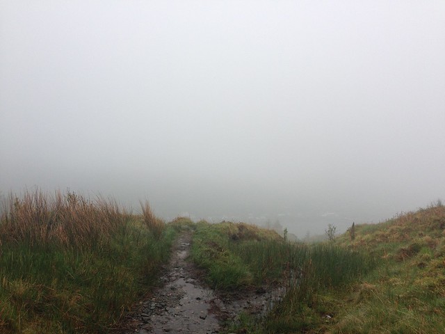
 ImageIMG_4610 by meganccoombes

So much for the views! The mist and fog only got worse the higher we climbed so I didn't bother much with photos, especially because the rain was pouring and I didn't want to damage my phone by getting it soaked (silly me! no waterproof case DUH! :shock: )

My friend, Heather, and I really enjoyed the wee scrambly bits and the climbing nearer the top of the summit. By the time we got to the last section we were absolutely soaked! Every step we took there was a squeltch in our boots and we did not bother with hoods or hats by this point as we were already soaked to the bone. I have never experienced rain like it! And the wind was horrendously strong. It made it a bit nerve-racking on the final ascent because of being near the edge and not knowing how far the drop was because of the fog.

We quickly found an area sheltered from the wind to sit and have a bite to eat. Not much time was spent at the top as the force of the wind and rain stung our eyes and faces, so we headed for the path back down. And this is where it all began to go wrong... :(

Firstly, we took the wrong path down and came to a field of boulders - to which I could not see a path afterwards due to the thick fog. So it was back up and try again. One last glance at my phone for GPS map to check where the path actually was and then my phone turned itself off :shock: the rain had got to it and we no longer had a route to follow. But we thought, 'not to worry, we will find the path,' which proved to be not so easy. We found that the path was very intermittant and faint in some areas on the way back down, but that may be due to the weather and the fact that the rain was creating streams of water everywhere!

We eventually made it down the other side of Beinn Narnain to begin Beinn Ime, however, lost the path AGAIN and decided that due to the weather it was probably best to head for the main path back down by the Cobbler and go home. But when we looked around we couldn't see the path... or the Cobbler... The fog was so bad we could hardly see 15ft infront of us!! So, being relatively new to this, and being out with my friend who is even less experienced than I am, panic started to set in. My phone wasn't working for GPS help, and Heather's phone didn't have a back up but thankfully she had enough battery in her phone. I thought it would be an option to try using the map and compass that I had brought with me as a back-up, but of course it was a paper map and the wind and rain tore right through it (I know, I know! I need a waterproof case - and now a new map!). The map then ended up in a sorry state...
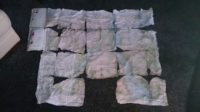
ImageIMG_4614 by meganccoombes
... and would have been ineffective anyway as the fog would have stopped me from being able to pin point anything to identify where we actually were. So, apologies to my boyfriend for lending me his map and then getting it back like this :lol: A new one has since been purchased along with a waterproof case!!

I think this was the moment which I felt the most fear. The weather wasn't letting up, the fog wasn't clearing, and I felt not only responsible for myself but for Heather also as she started to get really upset and panicky as for a moment it really did feel like we were stuck.

We found a fence and a gate, somewhere between Beinn Narnain and Beinn Ime, but could not see much else. It was then that I decided to take Heather's phone and contact Mountain Rescue to get some help with navigation. Due to weak phone signal I lost them a couple of times.

Just as I felt that all hope was lost, the fog cleared slightly and I could see more around us. To our left there was the fence and streams which ran downhill. I made a judgement call and decided that that was our best bet - to follow the fence and the streams downhill. The streams then turned into a river which we had to cross to find an easier and safer path on the other side, and then we came to a little Dam. It was then that Mountain Rescue were able to get back in contact with us, and asked me to describe what I could see. I told them what I had decided to do, and told them about the fence, river, Dam, and also that I could see a forrest on a hill far infront of us which I thought was Ben Donich. They said that it sounded like we were making our way down Glen Croe, and were happy for us to continue on our path as long as we were comfortable with it. Since we were also coming out at the wrong side, they said that they would send a few of the guys round in their jeep to pick us up and take us back.

After finding a path and continuing to make our way down the hill, I heard Heather say, "Megan, do you see what I see?!", and then I shouted with joy, "A ROAD!!!" :D spirits lifted as we made our way down to the road, until we came across a group of sheep and rams who were not for budging from our path. They looked like they were preparing for a square go! :shock: So we had to make a mini detour, climb the fence and make our way down the steep roadside at the bottom of the Rest and Be Thankful, where we found the guys from Mountain Rescue who were going to take us back for a cup of tea and to warm up before the drive home.

A long walk report, I know! But I just had to make this my first ever walk report! It was such a scary experience for me, however, has made my ambition for bagging all the munros all the more greater!! I don't ever want to be in that position again, and I have learned from my mistakes, but it has made my bug for exploring stronger!

I cannot say thank you enough to the guys at Arrochar Mountain Rescue Team! :D They were fantastic with us and were so helpful and attentive.

Hills, you haven't defeated me or scared me off! In the famous words of Arnie... I'LL BE BACK!! :wink:
Attachments

our_route.gpx Open full screen  NB: Walkhighlands is not responsible for the accuracy of gpx files in users posts

Last edited by smeggles7 on Wed May 21, 2014 10:48 am, edited 1 time in total.
User avatar
smeggles7
Mountain Walker
 
Posts: 21
Munros:8   Corbetts:3
Fionas:1   
Joined: Oct 23, 2013

Re: Eventful and Scary Attempt at Narnain and Ime

Postby weaselmaster » Tue May 20, 2014 7:19 pm

Had a wee smile at reading this - got lost in exactly the same place in clag back in september 12 when we were just starting out, wandered about in glen croe for a while before the mist cleared & we could see the Rest & Be Thankful car park and could orientate ourselves. Went out and got a Satmap GPS the next day!
Enjoy the next trip out :)
weaselmaster
Hill Bagger
 
Posts: 2433
Munros:277   Corbetts:217
Fionas:195   Donalds:73+30
Sub 2000:391   Hewitts:33
Wainwrights:15   Islands:28
Joined: Aug 22, 2012
Location: Greenock

Re: Eventful and Scary Attempt at Narnain and Ime

Postby BigT » Tue May 20, 2014 7:38 pm

You made the AMRT facebook page :wink:

Hindsight is easy so I'll say nothing. Glad you are safe and didn't walk off the edge of anything. Map cases are cheap, and learning bearings is free. A bearing from the fence gate to cobbler steps would have seen you ok. That's not criticism it's just an example of planning exit routes. Get back on the horse.
User avatar
BigT
Mountaineer
 
Posts: 83
Munros:9   Corbetts:5
Fionas:2   
Joined: Sep 21, 2013
Location: Glasgow

Re: Eventful and Scary Attempt at Narnain and Ime

Postby AnnieMacD » Tue May 20, 2014 7:50 pm

Great that you both got back safely and now have the determination to carry on. What doesn't kill us, makes us stronger and you certainly got your lessons. Like BigT, I highly recommend a dedicated GPS and I would also suggest going on a navigation course. It's easy to navigate when you can see all around you but when the cloud comes down that's when you need more knowledge and the one-day courses are great.

Well done you and maybe meet you on the hills some day (I'm a bit of a rookie too).
User avatar
AnnieMacD
Mountaineer
 
Posts: 789
Munros:25   Corbetts:15
Fionas:13   
Sub 2000:8   
Joined: Jun 25, 2013
Location: Applecross

Re: Eventful and Scary Attempt at Narnain and Ime

Postby SuperMillie » Tue May 20, 2014 9:43 pm

You're not alone....
I got lost on the summit of Ime in exactly the same kind of conditions.
Wandered around for a while wondering how the hell I was going to get off and almost fell down a steep gully when the clag lifted briefly, I managed to orientate myself back to bealach a' Mhaim but It was a scary feeling.
Promised myself that would never happen again so went out and bought myself an Etrex 30 and went on a navigation course - money well spent!

Well done for getting back safely and for persevering

Good luck with your future walks
SuperMillie
Munro compleatist
 
Posts: 164
Munros:108   Corbetts:1
Fionas:3   Donalds:5
Sub 2000:9   
Islands:12
Joined: Dec 31, 2012
Location: Livingston

Re: Eventful and Scary Attempt at Narnain and Ime

Postby Fife Flyer » Tue May 20, 2014 9:50 pm

Great descriptive report with a happy ending :clap: :clap:

I appreciate exactly how difficult it is navigating in low cloud & no sign of a path, you won't be the last person to get lost :wink:
User avatar
Fife Flyer
Munro compleatist
 
Posts: 2645
Munros:272   Corbetts:58
Fionas:39   Donalds:89+33
Sub 2000:134   Hewitts:2
Islands:5
Joined: May 15, 2013
Location: Guess?

Re: Eventful and Scary Attempt at Narnain and Ime

Postby smeggles7 » Tue May 20, 2014 11:56 pm

Thanks everyone! :D

Yeah, I saw that I had made the AMRT Facebook page! Did you see that they sneakily took a picture of the map and posted it?! Haha they found it quite funny.

They have taken my details and will contact me when they are holding a navigation course which I'm quite excited for!! :D and until then I'll share my boyfriend's GPS (if he will let me :lol: ) until I can get my own.
User avatar
smeggles7
Mountain Walker
 
Posts: 21
Munros:8   Corbetts:3
Fionas:1   
Joined: Oct 23, 2013

Re: Eventful and Scary Attempt at Narnain and Ime

Postby smudger71 » Wed May 21, 2014 9:38 am

I spent some time there a few weeks ago for nav. practice in the clag because that area is renowned as a navigational test piece, due to the lack of paths, the undulating terrain and the fact that there are several mountains in close attendance it is very easy to head off in the wrong direction.

In fact the only feature of much use in the clag is that fence, so good effort using that to get your way down.

M
User avatar
smudger71
Munro compleatist
 
Posts: 97
Munros:162   Corbetts:47
Fionas:24   Donalds:87
Sub 2000:14   Hewitts:65
Wainwrights:11   
Joined: Aug 9, 2010
Location: Glasgow

Re: Eventful and Scary Attempt at Narnain and Ime

Postby lomondwalkers » Wed May 21, 2014 11:04 am

Sounds familiar... http://www.walkhighlands.co.uk/Forum/viewtopic.php?f=9&t=9989 :lol:

Probably the biggest lesson I've had on the hills so far. Sometimes you need things to go wrong so you learn from it. Main thing is, no harm was done
User avatar
lomondwalkers
Mountain Walker
 
Posts: 854
Munros:143   Corbetts:57
Fionas:57   Donalds:73
Sub 2000:23   Hewitts:3
Wainwrights:3   Islands:4
Joined: May 5, 2010
Location: Bishopbriggs

Re: Eventful and Scary Attempt at Narnain and Ime

Postby smeggles7 » Wed May 21, 2014 11:16 am

lomondwalkers wrote:Sounds familiar... http://www.walkhighlands.co.uk/Forum/viewtopic.php?f=9&t=9989 :lol:

Probably the biggest lesson I've had on the hills so far. Sometimes you need things to go wrong so you learn from it. Main thing is, no harm was done


I just had a wee read of your post and I couldn't help but smile because your feelings were so familiar to mine... and seeing the A83 and the 'hands in the air moment' was similar to ours, however, we couldn't help but scream and shout and jump up and down :lol: it's good to know I'm not the only 'plonker' haha!
User avatar
smeggles7
Mountain Walker
 
Posts: 21
Munros:8   Corbetts:3
Fionas:1   
Joined: Oct 23, 2013

Re: Eventful and Scary Attempt at Narnain and Ime

Postby Mantog » Wed May 21, 2014 12:33 pm

Great post, just shows how things compound. The confrontational sheep must have seemed like final straw!
Mantog
Munro compleatist
 
Posts: 89
Munros:45   Corbetts:1
Fionas:5   Donalds:1
Hewitts:16
Wainwrights:21   
Joined: Mar 17, 2013

Re: Eventful and Scary Attempt at Narnain and Ime

Postby rockhopper » Wed May 21, 2014 12:37 pm

Entertaining, if scary at times, first report - good stuff. Glad to see all went well in the end and you're taking advice and leaning about what you need to do for the future. I'm pretty sure most of us can think of times when we've had similar experiences - just as long as we learn from them. What always amazes me is the fantastic response and reaction of MRT and the police ! - cheers :)
User avatar
rockhopper
 
Posts: 7446
Munros:282   Corbetts:222
Fionas:136   Donalds:89+20
Sub 2000:16   Hewitts:2
Wainwrights:3   Islands:20
Joined: Jun 1, 2009
Location: Glasgow

Re: Eventful and Scary Attempt at Narnain and Ime

Postby jmarkb » Wed May 21, 2014 12:38 pm

Wow, that's becoming a habit for WH contributors: third time already just this year!!!
User avatar
jmarkb
Mountaineer
 
Posts: 5880
Munros:246   Corbetts:105
Fionas:91   Donalds:32
Sub 2000:46   
Joined: Oct 28, 2011
Location: Edinburgh

Re: Eventful and Scary Attempt at Narnain and Ime

Postby smeggles7 » Wed May 21, 2014 1:16 pm

the sheep were probably the scariest part of the whole day :shock: I thought they were going to take us out! :lol:

Yeah, the AMRT were fantastic! Took us back for a cup of tea to warm us up while taking notes, gave us a snickers bar and then dropped us off at the car. Lovely guys! :D
User avatar
smeggles7
Mountain Walker
 
Posts: 21
Munros:8   Corbetts:3
Fionas:1   
Joined: Oct 23, 2013

Re: Eventful and Scary Attempt at Narnain and Ime

Postby mgmt! » Wed May 21, 2014 5:28 pm

glad all was well in an eventful first walk. concerned at some of the advice given. i wouldn't just buy a gps and venture out ! as stated in your report signal and battery failure are common. go to the mcofs website and read through what they have on navigation. learn to navigate with a map and compass first, then maybe buy a gps as a back up. the hills aint going anywhere fast, join a club and learn as you go out with people more experienced and im sure some will help you learn, but most of all, enjoy
mgmt!
Mountaineer
 
Posts: 540
Joined: Oct 18, 2010

16 people think this report is great.
Register or Login
free to be able to rate and comment on reports (as well as access 1:25000 mapping).

Next


Can you help support Walkhighlands?


Our forum is free from adverts - your generosity keeps it running.
Can you help support Walkhighlands and this community by donating by direct debit?


Return to Walk reports - Scotland

Who is online

Users browsing this forum: Deerplay and 65 guests