free to be able to rate and comment on reports (as well as access 1:25000 mapping).
On a 12th November in the mid 1830s Robert Dick, baker of Thurso, wrote to his sister,
“On Tuesday last I set out at two o’clock in the morning to go to the top of Morven. Morven is a hill to the south of this, and by measurement on the map 28 miles as the crow flies. But taking into account the windings and turnings of the road—up hill, down hill, and along valleys—it is a good deal more : say 32 miles from Thurso to Morven top.
“For the first 18 miles I had a road: the rest of the way was round lochs, across burns, through mires and marshes, horrid bogs, and hummocky heaths. I tucked up my trousers, and felt quite at ease, though I was ankle deep, and often deeper, for fifteen minutes on end, and sometimes more. When I had a marsh to wade I had it level, but when I had heather I had an awful amount of jumping. ... At last, however, I found myself on the top of the famous Morven.
…
“My object in ascending the hill was to gather plants, and of course I went up the steepest face to get among the crags and stones near the top. Morven is poor in plants. I found nothing new. True, the season was too far gone, but there in sheltered spots many of them still lived.
…
“I reached Morven top at eleven o’clock A.M. and left it at two p.m. It was now mid-day. The river of Berridale runs at the foot of Morven. The best way of getting over it is to wade through it; but what of that? The Highlandman walks best when his feet are wet, and so does the Lowlandman, if he could only be persuaded to try. In going to Morven I had waded no fewer than six burns, and at least a score of marshes. My feet had not been dry since seven in the morning.
…
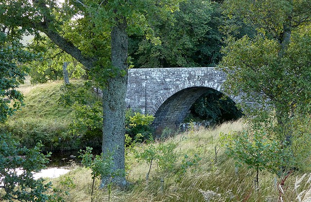
“The night became windy and stormy. Tremendous sheets of hailstones and rain impeded my progress, so much so that I thought, as Burns says, that ‘ the deil had business on his hand,’ and that he was determined to finish my course with Morven. But no! In spite of hail, rain, wind, and fire (in fact I had them all), I got home at three o’clock on Wednesday morning, having walked, with little halt, for about twenty-four hours. I went to bed, slept till seven o’clock, then rose, and went to my work as usual. Sixty miles is a good walk to look at a hill. And a contemporary view of Morven that perhaps Dick was familiar with.
(Surely Dick's letter has got to be a candidate for an 1830's Walk Report of the Month.)
Some have questioned whether it was possible to do this walk in the time Dick claimed, but he was a fit young man (mid 20s), who regularly walked 30 or 40 miles in one day to further his knowledge of natural history, fitting his trips around his work as a baker. Without knowing his exact route I would have thought this comes within Naismith's rule, Morven is only 700 metres high and the route there is largely flat. It certainly would be possible by some of the people who regularly post here!! What do others think?
Who was Robert Dick, baker of Thurso? Apart from being the town baker he was a very active natural historian with wide ranging interests which he actively researched both by reading the latest scientific publications and carrying out his own practical work. He was in contact with several well kent Victorian geologist, botanists and entomologists but Dick never sought fame for himself. Much of what we know about him comes for Samuel Smiles.
I became intrigued with Dick's walk and his choice of hill after hearing about him at an excellent local history meeting, so Morven slotted itself into my (our?) 'to do' list, but this tiny Caithness hill (yes I know it's the highest hill in Caithness

) never became a priority … until we had 4 dog free days which we planned to use on big hills in the west before spending time with family in Gairloch. At this point the weather intervened, the west, and even most of the east, looked dire, but the far northeast looked really bonny. Suddenly Morven became our target and Dick our hero. No way were we going via Thurso, the standard route in from Braemore would do – and Morven alone was our goal. Unlike Dick we had a late start – 11am.
There is a small car park just before the lovely bridge over Barridale Water
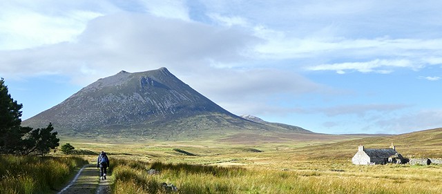
Follow the path to the old cottage at Corrichoich, passing through the estate buildings at Braeval and a small band of forestry to gain views of Maiden Pap and Morven.
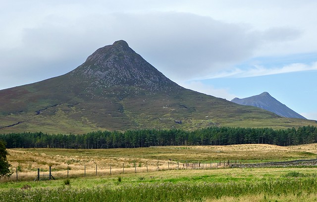
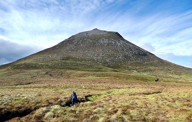
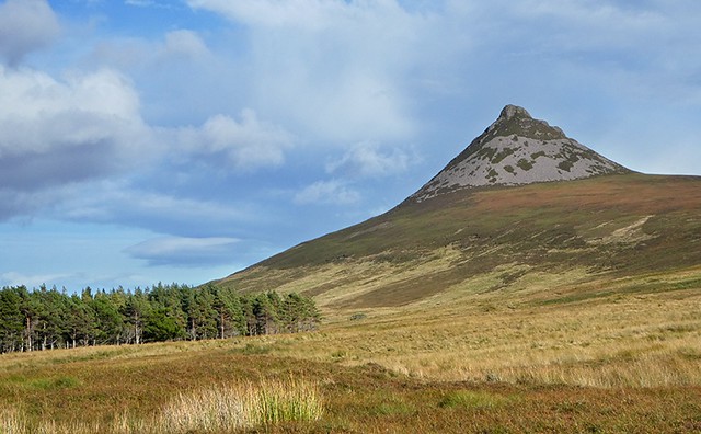
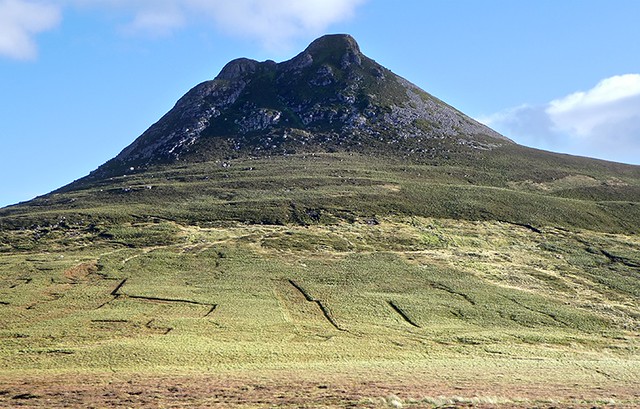
(Maiden Pap dominating despite being a mere 477 metres to Morven's 706). These two hills look as if they would be more at home in the northwest than among the gentle, rounded hills of the north east. Once past Maiden Pap there are clear views of Morven.
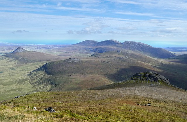
Carn Mor and the left, Morven with its 2 tops on the right
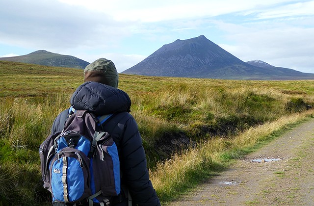
Morven with the old cottage at Corrichoich
The good track stops at the cottage so we followed faint paths through the grass and bog. We were aiming for the beallach between Carn Mor and Morven (as per the WH route). With hindsight we would have been better to go higher on the west ridge of Carn Mor, than trying to follow a line straight to the beallach as we ended up crossing a series of peat hags which cant be seen from the walk in, but fair slowed us up. Nothing like Dick's crossing of the Flow Country though!
Crossing one of the many hidden peat hags
When we reached the foot of the steep slope to the top we had a refueling stop before heading higher. There is a path in places which we found on the way up but not coming down. The path skirted some but led across other boulder fields, which was interesting. The rock on Morven is conglomerate, that is small harder bits of rock embedded in sedimentary rock which makes for very knobbly and unstable boulders. It was slow at first but we did get used to walking on this wobbly surface.
A flavour of the conglomerate boulder fields
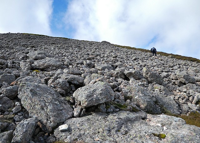
(A photo does not do justice to the rockiness of this rock or to the steepness of the slope

)
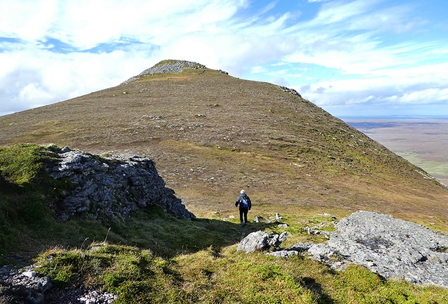
Our ascent was onto the lower of the 2 summits, from which there was an easy wander across to the true summit.
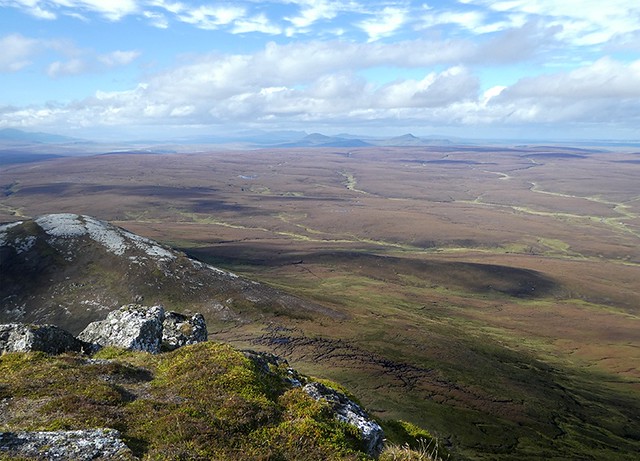
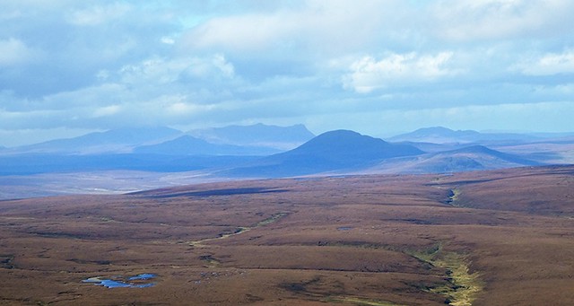
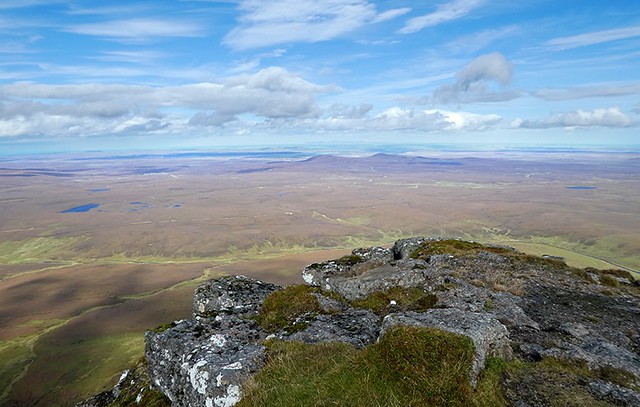
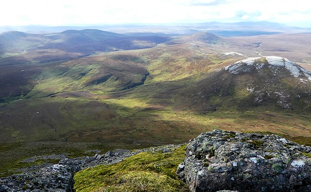
We hadn't really been aware of the stunning views on the way up, we were too concerned with actually getting to the top in one piece, but once we felt safe enough to look around the view were jaw dropping. At our feet was the Flow Country which Dick had crossed to get here. We could see north west to Ben Hope, north to Orkney, north east to Dunnet head and out to the north sea, south east to the Moray Firth and the Caingorms, the latter encased in cloud and what looked like heavy showers, and south west to the hills of Assynt, again the weather there looking fairly wet. The weather forecast was correct, on a grim day the far northeast was the place to be.
Looking north west towards Ben Loyal and Ben Hope - faint on the horizon
Zzoom to Ben Loyal, Ben Hope with its top in cloud
Looking north
Zoom to Orkney, with the Old Man of Hoy just about visible – well he was in reality!! Are the two bumps in the mid foreground Ben Graim Mor and Ben Graim Beg?
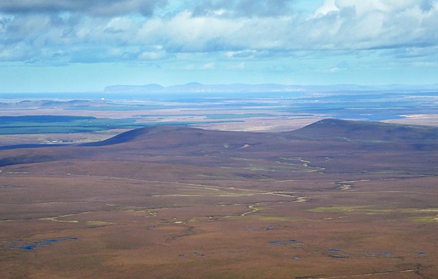
Looking north east towards Wick
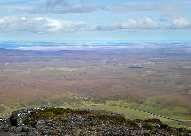
These views certainly made me realise the vastness of the Flow Country
East back along out route in – with the other Caithness Grahams and Maiden Pap on the left
West to Small Mount, Morven's westerly neighbour with Ben Klibreck faint on the horizon
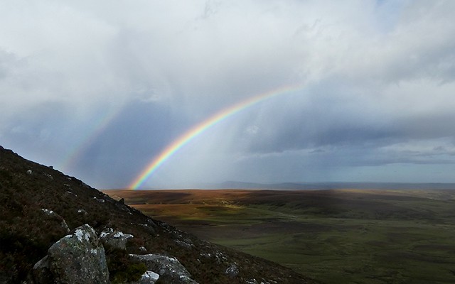
We had a leisurely lunch gazing out to Hoy, the views a magnificent payback for that wobbly rock. Eventually we had to face the trials of going down, but once passed the false summit we couldn't find the path we'd used coming up. That proved to be a benefit, after a bit of casting about we worked out our own, easier route down. Either we were becoming more adept at walking on rocking rock or we'd found more stable sections. On the way a heavy shower came bowling in from the southwest complete with hail and sleet. It didn't stay long and left a rainbow in its wake.
From the lower slopes we identified a less taxing route back, staying high on the flank of Carn Mor to avoid the peat hags. As a result our return to the track at Corrichoich was much quicker that on the outward journey.
Maiden Pap in the afternoon light
[/url]
Walking past Maiden Pap I noticed some geometric patterns on its lower slopes, which I hadn't seen in the morning. Are these the remains of peat cutting?
We were soon back at the car and then off down the road to Helmsdale for the night.
And Robert Dick? He often wrote to his sister of his exploits in the remote countryside in an effort to cheer her up when she was 'in low spirits'. He spoke of having a goal or purpose, of getting exercise in the open air as potential remedies and on one occasion used his experience as an allegory which he summarised with the words ...
“But I have no time to say out my say. Only this, sister, only this: never lose heart in the thickest mists you should ever get into; but take heart, for assuredly the sun will rise again, and roll them up and away, to be seen no more.”