free to be able to rate and comment on reports (as well as access 1:25000 mapping).
Two weeks ago, sitting on the summit of Beinn na Lap, Kevin and I discussed all possible options for approaching other Munros in this area. Carn Dearg and Sgor Gaibhre - from the south, adding a sidekick Corbett, Beinn Pharlagain. The 4 Alder group Munros - from Loch Pattack side (I can see a bike trip coming!). That left Aonach Beag and Beinn Eibhinn. SMC Guide gives Corrour as the main route, but we simply couldn't understand why? Rather than run back down along Loch Ossian to catch the last train, one could take a lazy-paced walk from Moy. Similar distance, similar ascent and the northern approach involved a circular of Coire a'Charra Mhoir, an absolute stunner when it comes to views

Of course these two can be added to Geal Charn/Carn Dearg traverse from Culra, but that would make a multiday trip and we just wanted to nip up a couple of Munros on a sunny Saturday

Our day turned out to be a cracker, despite strong winds on high level. We started from Moy and walked south on the track to Lubvan - cyclable until the ruin is reached, further on it's too boggy for 2 wheels. We didn't bother taking bikes as we calculated, we had more than enough daylight and even if we run out, it was easy enough to walk back on the track with torches.
Weather was said to be improving in the afternoon, but even the morning looked good and at the start of our walk-in, we admired lovely views west across River Spean:
"Our" hills could just about be seen from behind Beinn a'Chlachair:
The walk-in is about 8.5km but all on track/path. We saw a few other groups of walkers getting ready, but they all went to climb Chlachair group, we were the only ones attempting the "biggie" today.
Easy walking to start a day! Beinn na Lap on the horizon:
Creag Pitridh and Geal Charn:
It didn't take us long to get to Lubvan, where the track narrows to a path. This path must be regularly used by stalkers, because parts of it are being done up at the moment. Some stretches are still quite boggy though, typical gaiters and tuft hopping ground
View back to Binnein Shuas (left) and Creag Pitridh (right):
The ruin at Lubvan:
Pushing on along the river - the ridge ahead (Meall Cos Charnan) is 618m high but does not have enough drop to be a Graham, which is a shame as the shape looks intriguing!
The glen narrowed as we gained height, it was an absolutely stunning walk-in!
The path follows the Allt Cam all the way to the point where the river turns abruptly east. Here, according to the map, should be stepping stones. River was very low so no problems jumping to the other side, but on a wet day this crossing could be a potential problem.
We decided to take a break and have something to eat before the ascent began. Kevin was having one of his "I think I must have eaten some dairy" days, did he nick my jaffa cakes again??? I didn't want to force him to race me to the summit, we had plenty of time so let him rest and digest his sins

River crossing easy today:
Originally, we wanted to do the circuit anticlock, but changed our minds when we had a better look at the terrain. We decided, it would be better to leave the less steep slopes of Beinn Eibhinn as a descent route (that's the ridge behind me on the horizon):
Beinn a'Chlachair from behind

The less known, steep side of the Munro:
After the river crossing, the path disappeared very quickly and we were left to our own sources, plodding up the heathery slopes. It is possible to sneak up Meall Nathrach between the crags, but we opted for an easier approach and simply climbed at an angle up the ridge of Aonach Beag. Walking was easier than expected, low heather and grass, not much bog at all
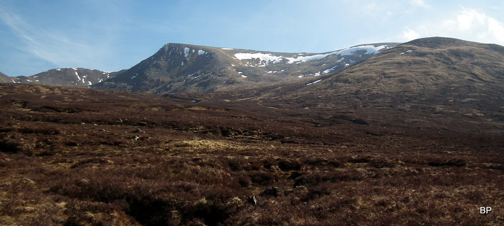
Soon, we could see our target summits: Aonach Beag (left) and Beinn Eibhinn (right):
As we gained the ridge, we had a glimpse back north, only to be slightly disappointed... What happened to all the views? Only now we noticed, that the air was unbelievably hazy as for this time of the year!
Haze or no haze, we marched on. It was quite windy higher on the ridge, but in dry, sunny conditions a bit of wind wasn't going to stop us

The final 250m was rather steep and stony...
...and it was a relief to reach the summit of "the other Aonach Beag" - Munro no. 202! Behind me, the ridge continues east to Geal Charn:
It would be possible to nip up Geal Charn as well (if fast enough) but we have other plans for that mountain. Aonach Beag is a good viewpoint, but sadly, the haze obstructed our views badly

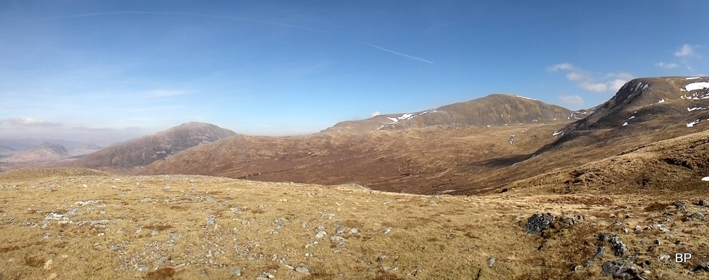
Panorama to the north:
You should be able to see Nevis Range on the horizon here, but we could just about make out the Easain Ridge behind Chno Dearg:
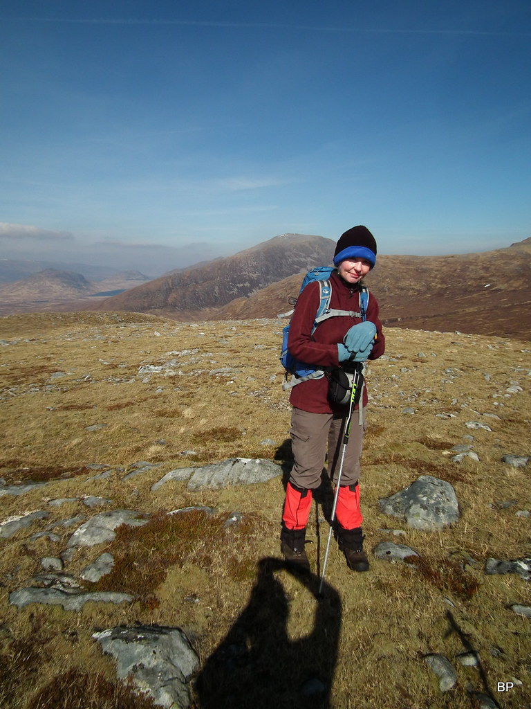
Wee Lucy's 41st Munro:
As we were leaving, we came across a few walkers coming from the Eibhinn direction, they were mildly surprised to see us
Ben Alder from Aonach Beag:
Ready to tackle another narrow traverse!
Looking south - Carn Dearg, Sgor Gaibhre and Beinn Pharlagain - our target for later this year! Shame we could hardly see them in that haze!
The full pano of Beinn Eibhinn. Opposite to Aonach Beag, this Munro is in the shape of a long ridge with vertical cliffs to one side:
On the way down, I spied a rock to pose for my veni vidi vici meow pose
The first summit was too windy to stay for too long, so we found a sheltered spot on the col and sat for a while with our traditional cup of hot tea and... hot cross buns (It's Easter time, isn't it?).
The climb to Beinn Eibhinn may look steep and narrow but it's only 120m of ascent, about 70m of the steeper section but no real scrambling involved here, a well-worn path all the way:
Looking back from the slopes of Beinn Eibhinn to Aonach Beag and Geal Charn behind:
Despite windy conditions, I was in my element and charging up the rocky slopes with renewed energy. Something in my mountain-infected mind was crying out: New Munros, new Munros!
On top of the steeper section - the rest of the ascent is pure pleasure, easy ridgewalking:
Ben Alder... and haze getting worse!
Panoramic view east:
To the summit of Beinn Eibhinn - my kind of mountain! Not only the name translates as "the delightful hill", it's also pronounced very similar to my name
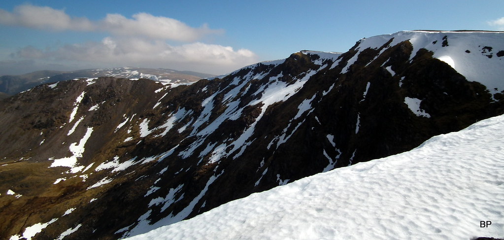
The summit ridge has 2 cairns on two different points along the cliffs. Both are marked 1102m on 1-25k map. Kevin's GPS said the second (NW) top is marginally higher, but I took snaps on both, just in case
Go winter, go! Panther cleaning the ridge the from overhangs
Such a shame about the hazy conditions. Only 2 weeks ago, we had a superb day on Beinn na Lap, when visibility was purrrrfect, now we could only see the misty outlines of nearby hills. Loch Ossian and BnL (right):
The true summit of the delightful hill - Munro no. 203!
Gazing into Coire a'Charra Mhoir... it felt more like June than early April. Usually, this time of the year, there would be substantial amount of snow on 1100m:
Panoramic views from the summit of BE:
.............
..............
Kevin (211M's) and Lucy (42 M's) on the summit:
We spent some time on the top, as the wind has dropped a bit and wasn't as nasty here as it had been on Aonach Beag. Our descent route involved walking along the rim of the corrie for a short time, just to enjoy the views for a bit longer...
 2017-04-08 beinn eibhinn 213
Last look at the mighty cliffs of Beinn Eibhinn:
 2017-04-08 beinn eibhinn 219
View north-east: Beinn a'Chlachair and Shios/Shuas twins:
 2017-04-08 beinn eibhinn 223
Descending along the shoulder of Sron an Fhuarain:
 2017-04-08 beinn eibhinn 225
The descent route was easy, mostly walking on short grass and soft moss, with scattered rocks, lower down the ground was a bit wet, but if you prefer to do this circuit anticlock, the ascent up this side would be less tiring than the steep slog up Aonach Beag.
Panoramic view of AB from the lower slopes of Eibhinn:
 2017-04-08 beinn eibhinn 235
I want to return here one day. Can't wait to climb the other Alder Munros - still 4 to visit here!
 2017-04-08 beinn eibhinn 233
We had to return to Alt Cam to pick the stalker's path again, from above it seemed like a neverending slog, but it's only 2km as crow flies:
 2017-04-08 beinn eibhinn 239
The final 100m of descent was steeper and quite wet from streams running down the grassy slopes. We aimed for the watershed, crossing Allt Gualainn a'Charra Mhoir and another stream, eventually running into... what Kevin called peat hag central:
 2017-04-08 beinn eibhinn 243
View back to the N shoulder of Beinn Eibhinn, our descent route to the right:
 2017-04-08 beinn eibhinn 241
Thankfully, the recent dry weather reduced peat hags to a minor nuisance
some tuft-hopping and careful maneuvering, but I wouldn't like to have to cross this watershed in wet conditions.
Having left the peathaggy world behind, we followed the wee stream, Caochan Dubh, to where it joined Allt Cam.
Allt Cam near the crossing point:
 2017-04-08 beinn eibhinn 247
The rest was history - a couple of hours of walking back along the path and finally track to Moy, weather still nice and sunny.
Allt Cam and Creag Meagaidh on the return:
 2017-04-08 beinn eibhinn 251
I simply have to recommend this route if you plan to take Alder group "in chunks"! On a long summer day, it's possible to add Geal Charn with little extra effort, and the circuit of Coire a'Charra Mhoir is a magnificent ridgewalk. In my opinion, this is the best way to fully appreciate "the other Aonach Beag" and its lower neighbour. I think the name "delightful hill" should speak for itself!
......................
Fingers crossed weather stays nice and sunny for the coming spring break. Happy Easter everyone! May the Easter Bunny bring you tasty choc eggs... and see you on WH Meet in Kinlochleven!
