free to be able to rate and comment on reports (as well as access 1:25000 mapping).
This story will be about two Corbetts not very well known to the public: An Dun and Maol Creag an Loch (aka A' Chaoirnich). This duo is awkwardly situated many miles away from the nearest road, but thankfully a track/path known as Gaick Pass goes right between them. They are very often approached by bike from the south - and this was my original plan, but for reasons only known to himself, my husband decided we'd walk it

Maybe he wanted to test his knee after it had annoyed him badly during our previous trip, I didn't ask. For me it was, as Germans say, ganz egal. I didn't mind walking the distance as long as weather was decent

The starting point is near Dalnacardoch Lodge, usually one can park either in a layby or somewhere around the Trinafour junction, but today we were surprised by extensive roadworks. The Trinafour junction was closed for traffic, so we had to drive down the A9 past Dalnamein Lodge, where we found a turn-off to the old road. It is a cycle route now, but due to the roadworks at the junction, it was temporarily open for car traffic so we could drive back up closer to our starting point. We found a good parking spot by a ruined cottage, about a mile away from the start of the right of way.
We didn't want to walk through the roadworks area (not sure the workers would be happy!), so we crossed the A9 first and then walked along the verge to the start of the track. About half way, I almost stepped on some large creature, hiding in the grass. It slowly slithered away and I had a good look at it - a big, fat adder. I haven't seen one for ages!
We were glad to leave the noisy A9 behind and turn to the Gaick Pass track. After a short stroll through the forest (surprisingly, no midges!) we walked out onto the open hillside. Weather was unsettled at the moment, showers passing by:
The track is excellent (for both walking and cycling) and after a short shower, conditions improved so we could walk at a decent pace, leaving behind the dangerous-looking cloud:
Soon we reached the empty building in Badnambiast, had a short lurk around, before continuing on the track:
An Dun was now visible on the horizon, a steep, shapely mountain, towering over the glen:
This is supposed to be a bridge, but it has turned into a ford:
Weather was definitely improving, but we knew there was a small front coming at about midday, which might bring low cloud and possibly more showers. We wanted to be on the first summit before the clag arrived, to see some views
I was in high gear!
The abandoned lodge:
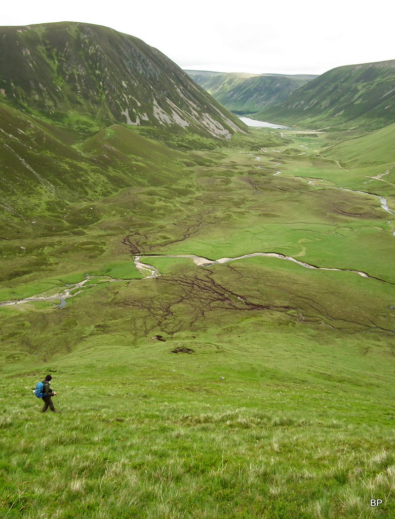
Because An Dun looks much steeper than its neighbour, we decided to tackle it first. For as long as possible, we kept to the walk-through path, as ground around looked boggy.
Edendon Water and Am Meadar from the path below An Dun:
 2017-06-19 an dun 051
 by
Ewa Dalziel, on Flickr
Hmmm... Which would be the best way to tackle this?
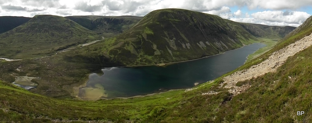
Panoramic view of both Corbetts with Loch an Duin in the middle:
I spied a faint path in the heather and followed it up. Surprise, surprise: the path becomes more obvious on steeper slopes and it can be followed almost to the summit! And who said some Corbetts are so unpopular that they have no paths???
It was a steep, annoying climb, but the views behind us - spectacular, especially down the glen we just walked:
We kept a good pace and in less than an hour we reached the summit plateau. The upper reaches of An Dun are surprisingly green and grassy. We noticed cloud charging towards us from the west, but at the moment, we could still enjoy the breathtaking view down to Loch an Duin and the vertical slopes of A' Chaoirnich:
 2017-06-19 an dun 083
 by
Ewa Dalziel, on Flickr
There are two cairns on the opposite ends of the summit plateau, the true summit being the northern one, but we stopped for a short refueling break by the first one:
The mist-bearing front reached us when we were walking along the summit ridge to the second cairn and for the time being, views were restricted, but we hoped that it would improve later on (it did!).
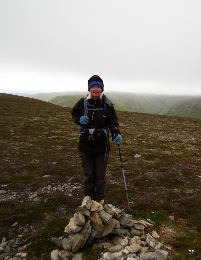
An Dun true summit: Corbett no. 125.
 2017-06-19 an dun 093
 by
Ewa Dalziel, on Flickr
The plateau was alive with golden plovers. Annoyingly, they were running around so fast that taking a good photo proved near impossible

At the moment, the cloud was touching the summit of A' Chaoirnich:
Looking up the Gaick Pass:
We examined the descent route carefully, The northern end of An Dun is just as steep everywhere, but with slopes overgrown with grass, it is possible to carefully drop back down to the glen. But first - another pano:
On the way down:
 2017-06-19 an dun 122
 by
Ewa Dalziel, on Flickr
Kevin was falling behind a little, I knew he didn't want to put too much pressure on his knee. Mine were both all right at the moment and I was glad that the descent from the second Corbett looked much less steep. Not sure my kneecaps would appreciate two sharp descents in one day!
Back in the glen, we considered climbing straight up the heathery slope of A' Chaoirnich, but it looked more like a vertical wall so we decided to walk along the track for a short distance, perhaps around the corner the angle would be less acute?
Weather improving over Gaick Pass:
The descent route from An Dun. Doesn't look too bad from below

Creag an Dubh-chadha and Loch Bhrodain:
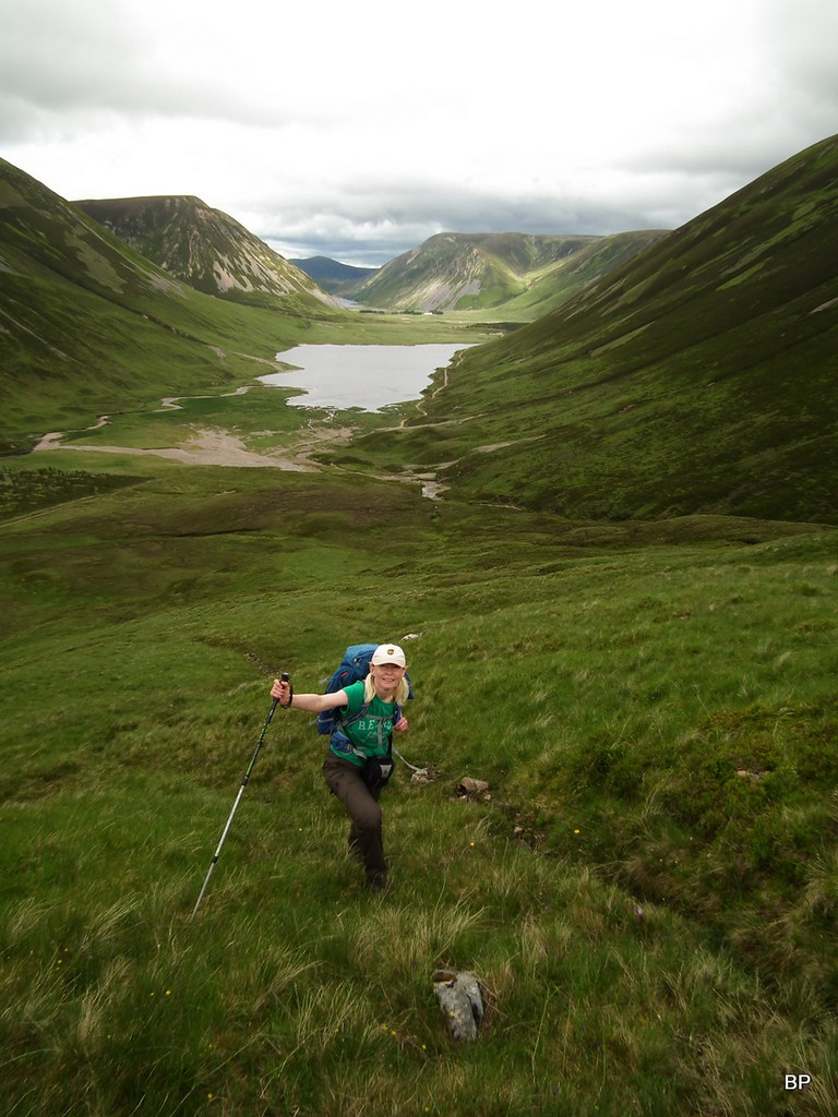
I found a better line of attack! About a mile up the track, the slopes seemed marginally less steep plus they were grassy rather than heathery:
Up we go! Despite it being "the weakest spot" in the line of defense, the ascent is still steep and boggy in places:
...but the views north to the actual pass are second to none:
Definitely not the easiest Corbetts in my career but well worth the effort!
 2017-06-19 an dun 153
 by
Ewa Dalziel, on Flickr
It's 300m of plodding up the steep side of A' Chaoirnich, then the angle eases off and the final walk to the summit is a pleasant stroll over grass and moss. We stopped to take the last look at the superb view up the pass:
The summit cairn is tiny and in winter conditions (or in thick mist) it would be hard to find! Corbett No. 126 (48 for Lucy):
 2017-06-19 an dun 169
 by
Ewa Dalziel, on Flickr
The summit is a good viewpoint to more distant hills...
...but much better views are from a larger cairn, situated about 600m due south, on the edge of the plateau. Here, we took a longer break: weather was good again, less windy and sun was out at last
Schiehallion to the south:
View west:
East to Benn Dearg. Now I know why it's called "Red Mountain":
The final descent is much easier, compare to the knee-jerking experience down from An Dun. Keeping close to the edge of the cliffs, we found a reasonable path. And the views down to the narrow glen between the two Corbetts are mind boggling!
Loch an Duin and Am Meadar:
Instead of traversing above the line of forest (WH route), we cut down straight to the main path. We found a sheep path going down at an angle, then descended the last 50m down steep, but manageable slope, covered in thick heather. Finally, having jumped over some peat hags and water canals, we found the Gaick Pass path again
Looking along Loch An Duin from the sheep path:
An Dun doesn't look so drastically steep from this angle!
One more pano:
 2017-06-19 an dun 208
 by
Ewa Dalziel, on Flickr
The slope we descended:
Kevin said he had to adjust his boots, so we took another break on the rocks by the river, relishing the warm, sunny afternoon. So far this year, it was mostly fighting rain, wind and cloud, so it was great to experience proper summer weather for a change!
One last look at the steep Corbetts:
It's a long, long way back to the A9...
Sunny Schiehallion on the way home:
It is a long day indeed (if walking) and bikes would be very helpful, but as we proved, it's a doable distance and can be enjoyed on foot as well! The temporary parking issues will be solved as soon as the roadworks on Trinafour junctions are finished. Despite the long walk-in, I can recommend this duo to any hillwalker: I think these two are the most interesting mountains in the whole area, with their steep slopes and the unique Loch an Duin wedged between them. Two Corbetts with plenty of character!
..................
Having performed the rite of Gaick passage, we returned home tired, but in excellent moods and the next day, ready for more adventures, we headed for the Formidable Fisherfields to climb Beinn Tharsuinn. Report to follow.
