free to be able to rate and comment on reports (as well as access 1:25000 mapping).
Studying our blue and red balloons a couple of months ago, I noticed we had one unclimbed Graham left in the Monadhliath/Glen Spean area, called Creag Ruadh, The Red Peak. It seemed too short a walk to bother in summer time, but a perfect half-day outing in winter conditions, especially if weather smiles - views from this wee hill should be spectacular, I thought. So the idea of a circular route on this modest Graham was born last December. As I'm a sucker for ruins and archaeology, I wanted to include Dun da Lamh, an ancient fort situated on one of minor tops of Creag Ruadh, into the circuit. Even with all the lingering, investigating and picture-snapping, this particular route shouldn't take more than 5 hours, with just over 500m of ascent.
Warning: fence-climbing abilities required

We drove to Laggan and past the village to the reservoir. There are some extensive construction works going on, access to building site, some tracks have been widened (for lorries and building equipment I presume), so it's a bit of a mess at the moment, but the starting point for the Graham is situated past all that mess. We parked on the grass just off the road near Sherrabeg, where we were welcomed by a special committee of locals...
Kevin wondered if they noticed Lucy the Lamb and came to say hello

Our route goes anticlockwise, up the NW shoulder to the summit first, then over a couple of lower tops, with a short detour to visit the ancient fort:
The day was bright, some high cloud but that would burn off later. Baltic cold in the morning

but views across the reservoir were good, I felt we'd have a good day pano-wise!
Parking space with a view:
Make sure you cross the bridge first, before entering the fields through a gate, wide open today. The route up follows the ridge seen behind me:
Somebody had been up recently 'cause we spotted fresh footprints. Good for us, if it wasn't for them we'd have to put crampons on higher up, as snow was rock-hard. The prints led us to a second gate and then up the ridge:
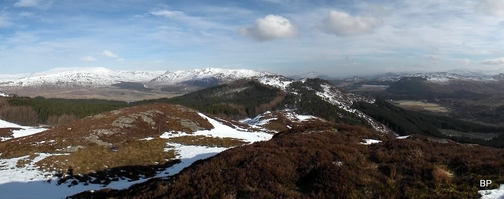
Kevin stopped every five minutes to take panoramic snaps, here is one - Geal Charn in the middle:
 2018-02-24 creag ruadh 024
 by
Ewa Dalziel, on Flickr
Higher up snow was deeper but still very hard, we aimed for another gate:
Past the third gate, we followed the fence for a short distance, then it was time to hop and jump up the bumpy ridge!
This ridge is a delight. Especially when covered in snow! We absolutely loved all the hopping and jumping over snow, ice and heather sticking out of it
The footprints meant, we didn't need crampons, but some of the bumps are quite steep in places and would require care in wet or fresh snow conditions.
Bryan Adams once sang "I gotta plead guilty havin' too much fun" - fits me good!
One more panorama from Kevin's camera:
 2018-02-24 creag ruadh 048
 by
Ewa Dalziel, on Flickr
Zoom to Creag Dhubh, the Newtonmore Graham:
The summit of "our" hill is not far away - less than 400m of ascent from the road altogether, but I was a bit disappointed that the bumpy ridge fun was coming to an end...
Mr Adams would say "It was fun while it lasted, let's do it all again"
The cliffs of Creag Meagaidh from the distance:
The upper reaches of River Spey and Corrieyairack Pass:
A moment of daftness, typical for wild cats on the loose...
The bumpy ridge turns south about 50m below the summit. There is a large cairn art the edge of cliffs (not the summit, just a marker), where we stopped for a few minutes for more landscape photography

West to Megi group. Note the deer fence to the left:
We were aware of the fence earlier as we climbed, but believed there would be a gate/stile somewhere. Sadly, there is nothing as such and for a short while we were convinced we'd have to climb the wobbly structure...
...but under detailed investigation, we discovered a hole in the wire net, big enough for a person to squeeze through (somebody desperate enough to gain the summit
). We had to take off our rucksacks, but soon we were on the other side, marching up the final meters of snow-covered slopes and admiring the frozen beauty of Loch na Lairige:
5 minutes later we reached the summit, marked by a trig point. In misty weather it would be just that - a trig in cloud - but today we had views to celebrate
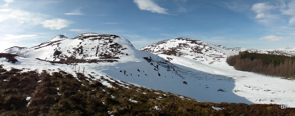
Sadly, the day was a bit hazy and more distant mountains merged in with the horizon, but the nearer peaks looked great in white cover. Megi in particular:
Geal Charn and Binnein Shuas:
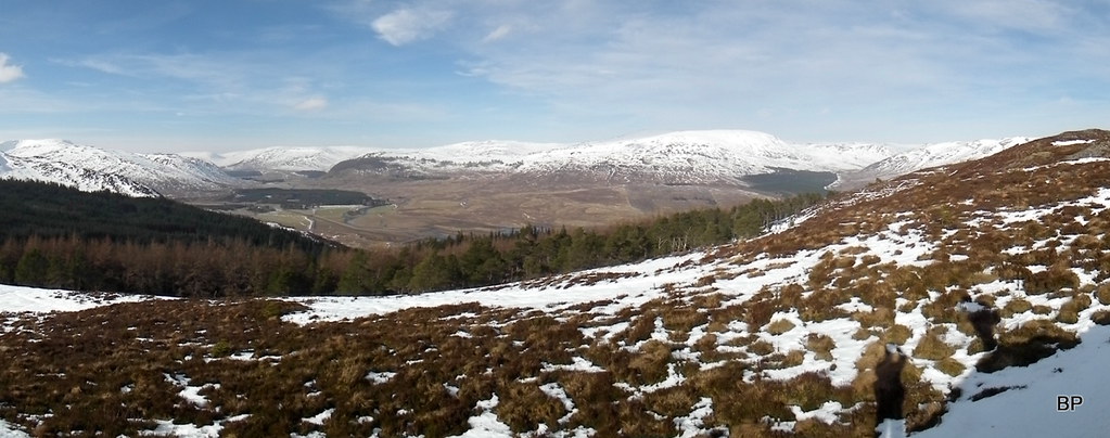
View south-east to Drummochter Pass:
Loch Laggan pano:
Zoomed:
My 85th Graham (Lucy's 52nd):
One man and his camera:
It was cold and quite windy on the summit, so we decided to carry on east to the next top (558m, marked on 1-25k map as Creag Ruadh itself) and maybe we'd find better shelter there. The descent was steep-ish and to avoid digging up crampons just for this short section, we traversed 200m to the right hand side (south), where slopes were less steep and we could simply run down the half-frozen snow, without risking a painful fall.
Views from the col:
My gaiter has come undone, so I stopped to fix it, then I heard a sound of rotors. Rescue helicopter flew above us, most likely returning from the search either on Creag Meagaidh or Sgurr Thuilm:
Seeing the copter made us think about the recent accidents on the hills and somehow it put our little outing in a completely different perspective. We're overly cautious these days, picking easy, lower hills and shorter circuits, not venturing on Munro monsters in deep snow (Alligin was an exception). It's not that we're not capable of harder routes, we're just playing it safe this year.
We reached the lower top and found that wind was much less annoying here, so found a suitable rock to sit on and spread our legs for lunch break
Views were still first class:
 2018-02-24 creag ruadh 138
 by
Ewa Dalziel, on Flickr
Back to summit of Creag Ruadh:
 2018-02-24 creag ruadh 143
 by
Ewa Dalziel, on Flickr
The ridge still awaiting us looked mouth-watering!
 2018-02-24 creag ruadh 144
 by
Ewa Dalziel, on Flickr
I was impatient to continue the bumping-jumping experience, so as soon as we warmed up with hot tea, it was time to carry on

Conditions were superb, blue sky above us, snow softened up enough to walk on it safely without crampons:
We descended the ridge, following a line of fenceposts. looking back, the hill behind us looked very wintry still:
 2018-02-24 creag ruadh 151
 by
Ewa Dalziel, on Flickr
At the edge of the forest (567914) this old line of posts meets a modern deer fence, 2 m high and again, no stile, no gate, no helpful holes
This time it was full-on fence climbing. Kevin went first, then I passed him rucksacks and clambered over myself. At least this fence was not wobbly so it supported our weight without any trouble
We landed in the forest, where, to our surprise, walking on softer snow was much slower than on the higher ridge.
Panther in the woods:
The next top in sight:
Traversing to the third top (565m, not named on 1-25k) was uneventful if slow due to thick layer of soft snow in the forest, but as soon as we reached it, we were mesmerized by the great views back to the ridge we have just walked:
2018-02-24 creag ruadh 151 by
Ewa Dalziel, on Flickr
View due north:
 2018-02-24 creag ruadh 172
 by
Ewa Dalziel, on Flickr
More to come... more wee tops:
The Cairngorms hiding in the haze...
From this point, we picked a heritage path going down to Black Wood. In summer time, this path would be easy going, but at the moment it was covered in snow, in places hard, in places slushy. A few sets of footprints suggested, people have been up to the viewpoint recently.
Looking back at the lumpy bumps:
Continuing on the path towards the fort:
Lower in the forest, the path was covered in ice so we opted for descending alongside on softer snow. We survived without any bum-meetings with hard ground, but we were a bit tired of the hard going and couldn't wait to see the fort!
Kevin on the not-so-safe path:
Dun da Lamh entering the stage:
 2018-02-24 creag ruadh 195
 by
Ewa Dalziel, on Flickr
We reached the last col where snow was less deep, and from here it was easy going up a forest path:
 2018-02-24 creag ruadh 203
 by
Ewa Dalziel, on Flickr
A metal info board gave us some information about the fort itself:
The fort is a cracker of detour on this route, especially if you're into ruins and archaeology. Sadly, some of the features were still covered in snow when we visited, but it's worth the few extra meters of climb!
The western side of the fort:
All the info about Dun da Lamh was taken from publication for Forestry Commission, Scotland "A TOPOGRAPHIC ARCHAEOLOGICAL SURVEY OF FIVE PICTISH FORTS IN THE HIGHLANDS" (March 2011)
1. The fort is 110m long, east to west, and 30m to 75m wide. The interior of the fort covers an area of some 4000m2. It is very uneven and includes several rocky outcrops.
View west from the edge of the ramparts:
2. The ramparts are built from small slabs, up to 0.5m across and 0.1m thick. Part of the original face of the rampart survive above the rubble around all sides of the fort, but is best preserved towards the west end of the fort. The rampart is up to 7.5m wide, but generally between 4m and 5m. The inner face of the west rampart has been cleared at several locations exposing a height of over 2m. The largest clearance is located at the north-west corner and is up to 2.1m deep. There is a clear change in the build at the upper parts of the rampart at this point suggesting the
upper 0.5m has been re-built, most likely to be reconstruction associated with a Victorian investigation.
3.The current access to the fort is along the path from the west, but this is not the original entrance as the face of the rampart survives at this point. However there is a marked dip in the rampart material on the south side of the fort that probably marks the position of the original entrance.
4. There are a number of features within the fort but most of these appears to post-date the abandonment and collapse
of the ramparts. Two small dug-out shelters have been built into the rampart at the south-west corner of the fort.
These are likely to be associated with a look out station built by the Home Guard during World War II.
Possibly, the ancient shovel has been left in one of them
 2018-02-24 creag ruadh 209
 by
Ewa Dalziel, on Flickr
5.There are other features within the fort area, which we couldn't place due to snow cover. These include: shooting butts, low stone banks, semi-circular and circular features defined by rings of stones on top of the rampart rubble and a stone lined well in the north-western part of the fort.
Dun da Lamh is also a fantastic viewpoint, so we took another break here
 2018-02-24 creag ruadh 223
 by
Ewa Dalziel, on Flickr
The return route can be done by cutting due north through the dense forest, but we didn't fancy that option and took more walker-friendly descent down the path to the south-east (part of mountain bike trail) to join a forest track in Strath Mashie. Sadly, part of that track has been bulldozed for the building site access, so no photos from this section. We returned to the edge of the reservoir, for the final mile of pleasant stroll along the lochside.
 2018-02-24 creag ruadh 229
 by
Ewa Dalziel, on Flickr
Overall, a very entertaining route. Highly recommended, as long as you don't mind fence-climbing. Maybe there is a hole or a stile somewhere nearby, but we didn't bother looking for it
It would also be boggy in places in warmer conditions, especially when traversing alongside fences.
..............
So that was Saturday's dose of hillwalking. But as Mr Adams sings: "get out while you can", we took the opportunity on Sunday as well and continued our Graham bagging journey, this time a longer escapade with crampons and perfect ridge walking. TR to come soon
