free to be able to rate and comment on reports (as well as access 1:25000 mapping).
Our second day on Skye, very low cloud in the morning, so we agreed that the best would be to climb something low, to hopefully get some views later on. The Trotternish Ridge is so popular with tourists, that we preferred to stay away from places like Storr or Quirang. Having climbed all the Red Cuillin hills, we still had a certain Skye Sub'2000 Marylin on our to-do list. It's been on that list for ages but there was always something else to do and we never had time to explore Ben Tianavaig. Now, time has come to pay true justice to this wee mountain...
There are two approaches to Ben Tianavaig, one from Loch Portee side, another from Loch Tianavaig. We opted for the latter as it looked more interesting on the map. Apart from climbing to the summit (which is said to be a superb viewpoint) we planned to spend some time exploring the "inner sanctuary" of oddly shaped rocks and boulders, situated on the steep eastern slopes. We were not disappointed by this wee traverse and what's important, we stayed away from crazy hordes with selfie sticks, running around, taking silly photos of themselves and posting it on Facebook

We didn't meet anybody when doing the Tianavaig circuit and it looks like this particular walk is still not as popular as the rest of Trotternish Ridge.
Yes, Ben Tanavaig is technically the termination of the Trotternish Ridge. It's made from the same type of rock and sits at the very end of the giant ancient landslide.The sedimentary rocks from the Jurassic age gave way to the great
weight of the basalt lavas, sitting on top of them. The landslides led to the the creation of awesome labyrinths of huge blocks, pinnacles and other "weirdos". of which The Old Man of Storr and various rocks of The Quirang sanctuary, are the best known examples.
OK, so much for geology. It's an interesting area even if you are not into investigating different types of rocks. It's a secret land of make-believe, where you can forget about the grey reality and for a few hours pretend to be a part of a fairy tale

The route from Camustianavaig starts from the car park by the picnic tables, in front of the stony beach. In itself, this is a lovely, quiet spot. A few tourists wandered around when we arrived but no crowds, which was good
Tianavaig Bay in the morning:
We had WH walk description and a Skye guide book with us, which was helpful on the initial stages of the walk. The start of the hill path up Tianavaig is hard to spot and it was overgrown with bracken higher than us! Thankfully, once on the hill slope, the path is not as badly overgrown and easy to follow:
Looking down to Tianavaig Bay:
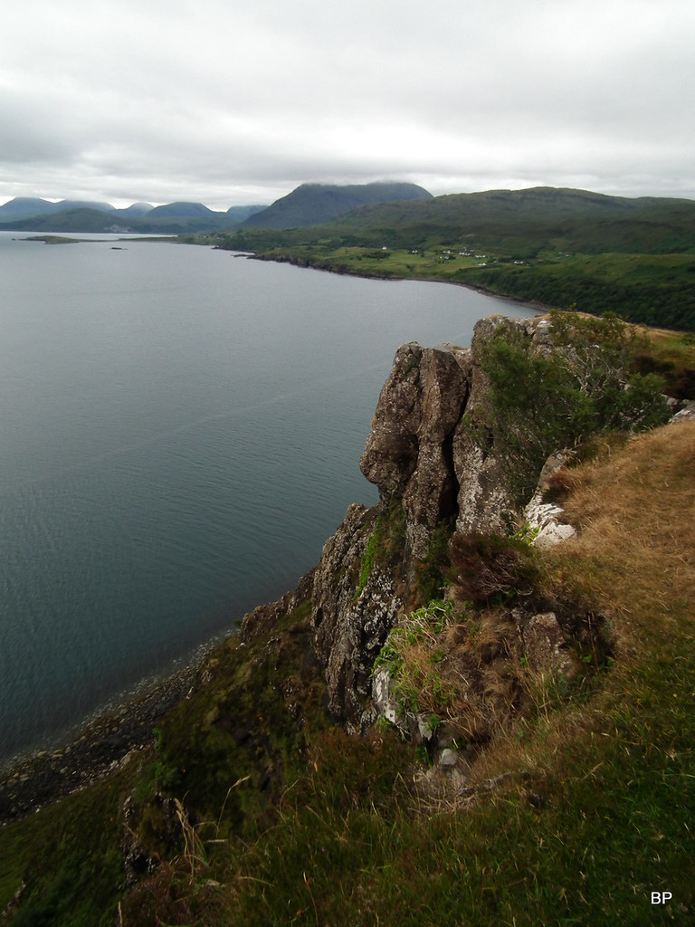
Very quickly, the path comes close to the cliffs and basically 90% of the ascent route follows the edge of the vertical drop, so care should be taken on this route, especially on a windy day. The cliffs drop all the way down to the sea and views are amazing from the very beginning! Initially, the day was cloudy but as time passed, the clag lifted off the higher hills in the south, blue sky appeared above us and we were in for a magnificent adventure in the world of make-believe
Cliffy cliffs:
 2018-07-12 skye 028
 by
Ewa Dalziel, on Flickr
Looking south, Glamaig on the horizon:
 2018-07-12 skye 021
 by
Ewa Dalziel, on Flickr
Across the water, Isle of Raasay:
The Red Cuillin:
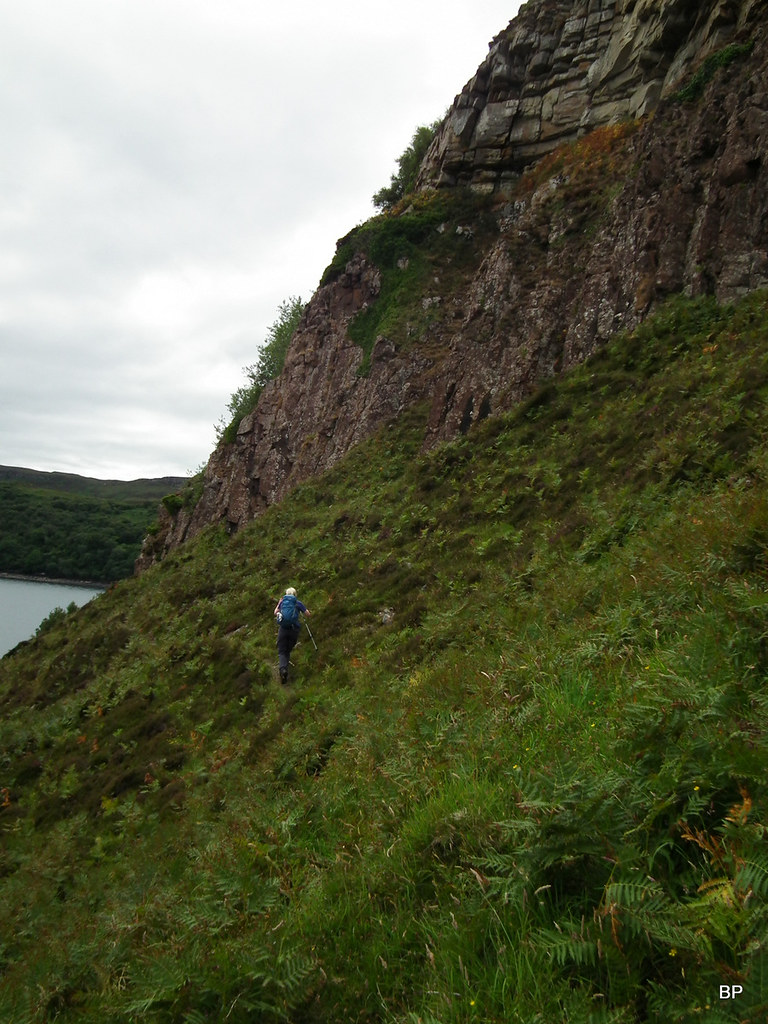
Walking up the cliff path:
Ben Tianavaig is only just over 400m so not very high, but what it lacks in height, it gains in its magnificent scenery. There are a few paths at a different distances to the cliff edge, so pick one that is the most suitable for you. I chose the one closest to the edge:
As we gained height, we caught the first glimpse of what was yet to come, the "inner sanctum" of Ben Tianavaig, the rocky oddities in the shadow of the big cliff:
The Sound of Raasay was busy with boats...
Panther stunned... I knew this was an interesting spot, but didn't expect such views!
Looking south-east to southern Skye and Scalpay:
The sanctuary from above - looks like a good place to play hide and seek!
The final climb to the summit:
We saw nobody else doing this walk yet were not alone on the slopes of the hill. All around us were birds of different shapes and sizes. One particular individual followed us for most of the way to the summit:
It's a ring ouzel (Turdus torquatus). According to RSPB :
"The ring ouzel is primarily a bird of the uplands, where it breeds mainly in steep sided-valleys, crags and gullies, from near sea level in the far north of Scotland up to 1,200m in the Cairngorms." Did you know that it has red UK conservation status? Which means the population has declined by at least 50% in the last 25 years. I was glad to see these birds jumping happily around us on the slopes of Ben Tianavaig. Obviously, they love the rocky sanctuaries of Trotternish
The summit of Ben Tianavaig has a trig point and superb views in abundance. Lucy was in her element!
...and so was Panther! Looking out in the distance...
We spent some time on the summit, taking photos and videos. All I can say... BT is a first class viewpoint!
Panoramic view north to the rocks of The Storr and to Portree below:
The cliffs of Beal Point are nearly 300m high!
Storr and Old Man zoomed:
Portee and Outer hebrides on the horizon:
View east to Raasay and the sanctuary below:
Panorama south:
After the long photo session on the summit, we continued along the edge of the cliffs for a short time to a spot, where the angle eases off and offers access to the inner sanctum... To the land of make believe!
Posing on one of many rocky outcrops:
The descent is steep-ish but a faint path can be followed:
In the sanctuary, below the cliffs, we found many places where we could mess around

I was particularly interested in a small pinnacle, looking like a mini-version of the Old Man:
The rocks above the sanctuary:
Kevin said, he was officially letting me of the leash so I could run around crazily and meow as much as I wanted
So I simply had to have a closer look at the mini-Old Man:
The sanctuary is an amazing place. We investigated every rock and took hundreds of photos, below just a few chosen (with great difficulty
).
Panoramas of the sanctuary:
The mini-Old Man seen from the less steep side:
Panther investigating one of the rocky oddities:
The lower line of pinnacles, as photographed by Kevin:
The lower pinnacles from below:
Kevin studying the final descent route:
Another odd rock on the way down:
 2018-07-12 skye 224
 by
Ewa Dalziel, on Flickr
As we descended slowly down to the sea level, past all the rocky weirdos, we found another vague path, which eventually took us down to just above the shoreline:
As we continued on the path, it seemed at some point that it was going nowhere, but as the available route descriptions said "follow the path at the bottom of the cliffs", we trusted them and continued to iffy-looking passage:
 2018-07-12 skye 258
 by
Ewa Dalziel, on Flickr
...only to find out that there was no iffy passage. The path contours below the cliffs and then climbs a short, easier section, and finally traverses to the rocky beach in Camastianavaig. It is overgrown in places, but if you stick to it, you'll emerge on the beach eventually.
The only obstacle we encountered: giant bracken
Having returned to the car, we still had some time to spend, so we studied the map and WH for a shorter cliff walk. We didn't want to go nowhere near the popular tourist spots, but luckily, there are still quiet places on Skye. One of them is Brothers' Point - Rubha nam Brathairean, just north of The Storr. We drove to Portree first for a compulsory purchase of new sun hats (forgot the old ones from home) then headed north past the Storr madness. Details of our second walk in my next TR.
