free to be able to rate and comment on reports (as well as access 1:25000 mapping).
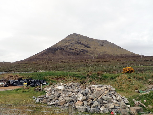
A settled looking weather forecast prompted me to consider getting over to Harris to climb The Clisham. We could take in Glamaig and either something on the Cuillin Ridge, or climb Garbh-bheinn for A's tally, as I'd already climbed it twice. It would mean only getting 2 Corbetts for myself over the weekend, below the required rate as they say in cricket, but sometimes you have to roll with it. Drove up to Sligachan on Thursday night, the hilltops shrouded in mist but a rosy glow on the flanks of Glamaig, some rain off in the distance creating a dense rainbow. The campsite wasn't particularly busy, at least not with tents, and we took one of our favoured spots on a small rise (memories of being flooded by the rapidly rising river still linger

). A fairly peaceful night apart from one snoring neighbour.
 P5090107
 by
Al, on Flickr
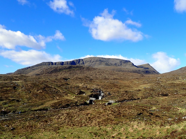
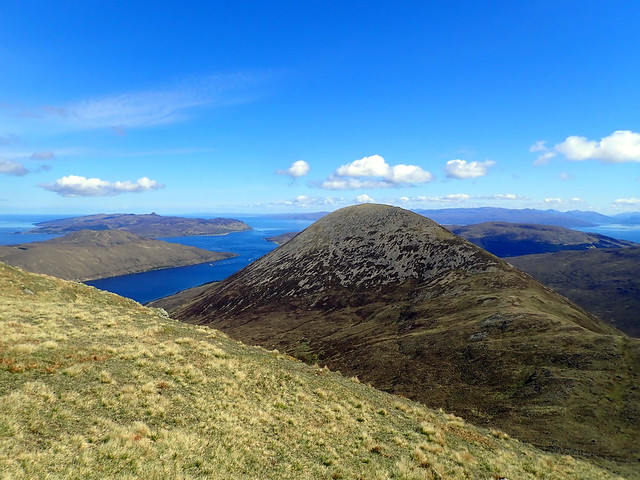
Friday morning was bright but chill. I'd decided we'd do Glamaig then head up for the early afternoon ferry to Harris, no need to rush with such a short hill. Rather than slog up the scree from the Slig, I routed us from Tormichaig, over the Simm of An Coileach, following the course of an old fenceline. We parked in a large layby a couple of hundred metres north of the start then proceeded over some boggy fields where a faint path wove its way up the steepening shoulder of An Coileach. Fine views over to Raasay, a smattering of new snow on the tops of the Cuillin. Arriving at the summit of the Simm, all that remained was a gentle grassy walk up to Sgurr Mhairi and Glamaig was in the bag. We descended by the same route. I think this is a better way to go Glamaig, to be honest.
An Coileach
 P5100108
 by
Al, on Flickr
Looking out to the Inner Sound
 P5100110
 by
Al, on Flickr
A little new snow on The Ridge
 P5100112
 by
Al, on Flickr
The Beinn Deargs
 P5100113
 by
Al, on Flickr
Sgurr Mhairi
 P5100114
 by
Al, on Flickr
Raasay
 P5100116
 by
Al, on Flickr
 P5100118
 by
Al, on Flickr
With time on our hands - it was only 10.45 when we reached the car - we headed up to Portree to visit the well stocked health food shop and load up on weirdo vegan produce. Suitably replete, we drove round to Uig, stopping for lunch at a layby overlooking the harbour. Big lines of traffic waiting to board the ferry - we were going on foot, so no worries about not getting a place on board. We sat in the sun, wrapped up against a chilly breeze, and awaited the ferry arriving. Took a wander along to the campsite at Uig - never having ccamped there before I wondered if it would be better to head there after the late boat back rather than drive down to the Slig again. The owner, who had been trimming the grass, greeted us and said it was fine to turn up at 11pm. A calm crossing followed, sunshine over the sea although, disappointingly, as we neared Harris it seemed there was a big raincloud over the island. I mused that it seemed unfair to leave Skye on a lovely sunny afternoon to be caught up in rain.
My plan was to walk into Gleann Lacasdail, making for The Clisham, stop somewhere in the glen and maybe climb the Marilyn Sgaoth Aird that evening, climbing The Clisham on Saturday and returning (if I could twist A's arm enough) over a second Marilyn, Todun on the way back to the ferry on Saturday night. From past experience we knew the going was good along Gleann Lacasdail so time shouldn't be an issue - the evening boat didn't sail til after 9pm.
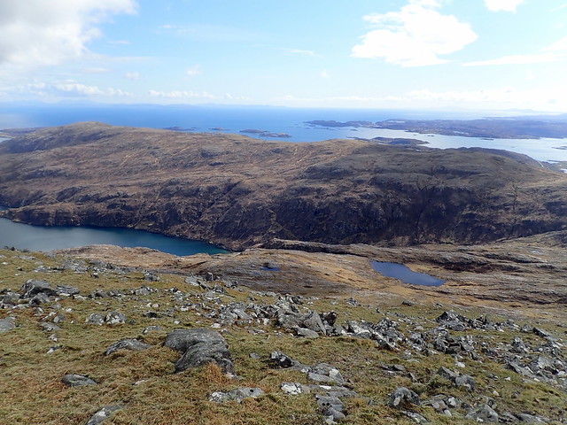
As we stepped off the boat, we were heartened to see the rain had abated and drawn away to the north of the island - leaving us with some fine sunshine. The colours of grass, flower and tree were more intense after their recent bathing and there was some warmth in the afternoon sunshine. We walked out of Tairbert on the road, as far as Urgha Beag, where we thankfully turned off onto good track up the glen. There are not many places suitable for pitching a tent along this path - the ground being bumpy and heathery, so we decided to call a halt before the head of the lochan, where there's some flat grassy areas - this was where we'd camped on our previous visit. Luckily this is also right at the start of Glen Dibidale, from where we could ascend Sgaoth Aird. The rocky shoulder of Sron an Toistear juts up from the flat glen - like all the hills in Harris, a rough craggy presence. We had our tea then set off into the coire, initially following the line of the river then steadily ascending the steep side wall of the coire. As we neared the summit, The Clisham loomed up from the other side, a muscular conical mountain from this angle. Onto the flat, rock strewn summit plateau in time for some great evening views. To our left, across Loch a Siar, the dramatically folded cliffs of Mullach Buidhe; to the north a clear-ish view of the St Kilda islands (which had A salivating); The Clisham with the group of three fine Harris Grahams beyond it - what a wonderful place to be on a sunny evening. It was still too early to contemplate waiting for the sun to set, so we returned to the tent, roughly following the line we'd taken up. There was stillness and calmness around overnight - the burbling of the nearby stream lulling me to sleep, the only other sound being an occasional far off bark of a deer.
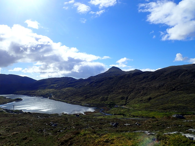
Late afternoon in Tairbert
 P5100119
 by
Al, on Flickr
Gleann Lacasdail
 P5100120
 by
Al, on Flickr
Sron an Toistear
 P5100121
 by
Al, on Flickr
View back down to the loch/tent pitch
 P5100123
 by
Al, on Flickr
Todun in the background
 P5100124
 by
Al, on Flickr
The Clisham
 P5100126
 by
Al, on Flickr
View south
 P5100127
 by
Al, on Flickr
Understated cairn...
 P5100129
 by
Al, on Flickr
 P5100131
 by
Al, on Flickr
Looking west
 P5100132
 by
Al, on Flickr
The Clisham and Grahams behind
 P5100133
 by
Al, on Flickr
 P5100134
 by
Al, on Flickr
Todun
 P5100139
 by
Al, on Flickr
 P5100140
 by
Al, on Flickr
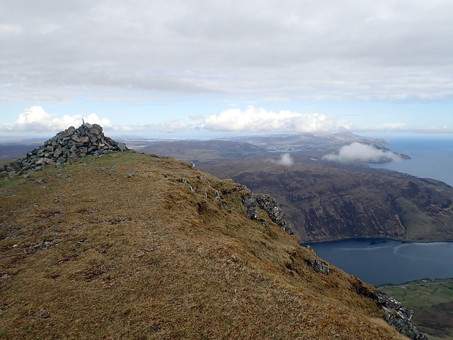
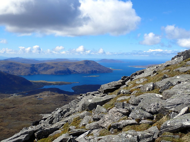
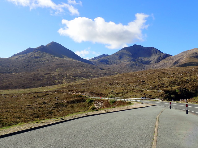
Saturday morning was just as fine as the previous evening had been, although there was a brief rain shower around 5am. We made a leisurely start, packing up the tent once it had dried in the sun, and following the track northwards til it met the road. Last night's hill looked even more impressive from the north. We continued along the road, busy with buses, campervans and bikes, til we came to the parking area at the start of the "direct" route up The Clisham. Having done the horseshoe last time I felt we could take a different line of ascent on this occasion - although the horseshoe is a fine walk and the weather today was far better than when we were here previously. We stashed most of the camping gear behind a large rock so that we didn't have to lug it all the way up and down the mountain and set off over squidgy, boggy ground, following the course of the stream and a definite walkers path. The ground dried out as we gained height and got onto more stony terrain. There are some bouldery sections which can be skirted round or gone over - soon we were at the top with a vista containing the beaches of Luskentyre, Scarista and the dunes of Taransay in a sapphire sea. I do like Harris - especially when the sun is shining. We sat and had lunch, shortly being joined by a man who'd come up from the other side and was enjoying the start of a fortnight's walking holiday.
Our objective
 P5110142
 by
Al, on Flickr
Last night's hill - Sgaoth Aird
 P5110143
 by
Al, on Flickr
Loch Seaforth
 P5110144
 by
Al, on Flickr
 P5110146
 by
Al, on Flickr
 P5110147
 by
Al, on Flickr
Looking west towards the beaches
 P5110148
 by
Al, on Flickr
Summit - the Clisham
 P5110149
 by
Al, on Flickr
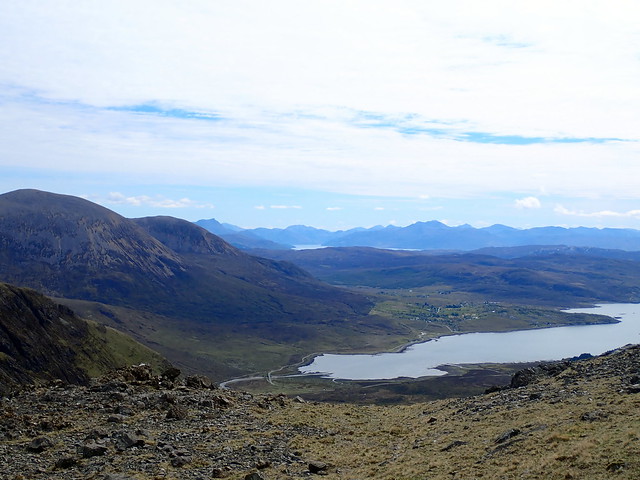
We took the opportunity to look over the map for the best way to climb Todun. I'd done a there and back route from Gleann Lacasdail, but I was sure there'd be a more ergonomic and pleasant route to take. After sitting in the sun for a time, we wound our way back down the mountain, meeting another two couples on their way up. Collecting the camping gear we returned to the firm surface of the road and headed towards Maaruig, dropping down to the road that leads to Reinigeadal. We could see the steep cone of Todun rising above us - no lightweight Marilyn this (nor indeed was last night's hill) - over 500m of ascent from our sea level start.
We follow the road up towards Todun
 P5110151
 by
Al, on Flickr
 P5110153
 by
Al, on Flickr
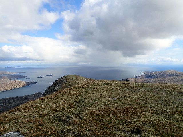
We kept to the road for a bit, gaining a bit of height on good surface before surrendering to the bogs and tussocks. Passed some sheep who looked at us with considerable curiosity (or maybe it was hunger) then set off up the hillside. Tackling the hill from this direction gives a steady incline and the reward is more fabulous views - over Loch Seaforth, back to Skye and the mainland beyond. A glorious vista, with no sign of mankind apart from the abomination of fish-farms in the loch below. Various bands of rain swept around us - out to sea and also over the inland lochs, but we yet again kept dry and in the sunshine. Having reached the summit we considered the best way on from here. We could see a fine looking path climbing from Loch Trolamaraig up towards Beinn Tharsuinn - although this meant another back-to-sea-level then up another 300m I was captivated by what I imagined to be a smugglers' trail. However, getting off Todun was not an easy matter. The map suggested that following the SE shoulder was relatively trouble free, but there were lots of crag bands, which were more problematic on the western aspect. In the end we had to head back north for a bit and descend towards An Reithe, then we took a SW line, missing out on my smugglers path but also avoiding a lot of loss of height. The ground underfoot was less boggy than I'd feared and around 5 we stopped for tea, putting up the tent to give some shelter from the cold wind. A further hour and a half saw us back on the road at the southern end of Lochannan Lacasdail and heading back into Tairbert to await the ferry.
Curious/hungry sheep
 P5110154
 by
Al, on Flickr
 P5110155
 by
Al, on Flickr
Loch Seaforth
 P5110157
 by
Al, on Flickr
Todun
 P5110159
 by
Al, on Flickr
 P5110160
 by
Al, on Flickr
Rain out at sea
 P5110161
 by
Al, on Flickr
"Smugglers path" if you look closely
 P5110162
 by
Al, on Flickr
The craggy rear end of Todun
 P5110163
 by
Al, on Flickr
View back to The Clisham
 P5110164
 by
Al, on Flickr
Towards Tairbert
 P5110165
 by
Al, on Flickr
 P5110167
 by
Al, on Flickr
 P5110168
 by
Al, on Flickr
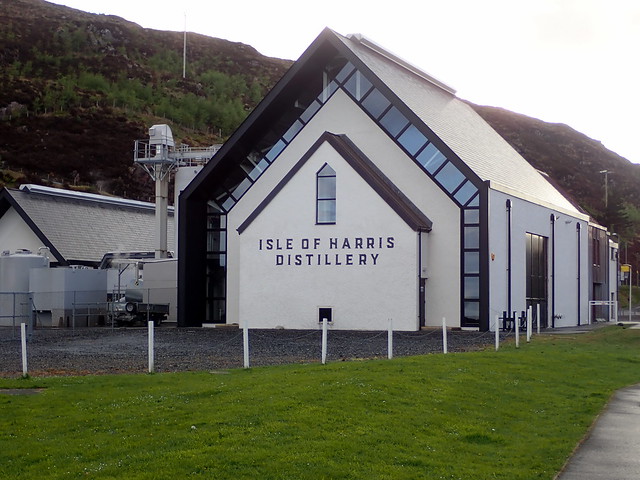
We had a wander over to the new-ish Harris Distillery, near to the ferry terminal, then waited for the boat to arrive. Another calm crossing, this time with the added boon of a sunset over the islands we were leaving behind. Both of us were quite tired after our exertions on Harris and walked slowly off the boat back to the car, then drove round the corner to the Uig campsite. Quite a few vans and a small number of tents, but lovely and quiet. we pitched, had a late night snack of rhubarb pie & custard then turned in for the night.
 P5110169
 by
Al, on Flickr
 P5110171
 by
Al, on Flickr
 P5110174
 by
Al, on Flickr
 P5110176
 by
Al, on Flickr
Another bright and beautiful morning! What joy to be on Skye in the early morning sunshine, sitting out to eat breakfast without the merest hint of a midge. The campsite was very pleasant, with the best grass to pitch on I've encountered anywhere, although I'd only give the showers 4/10. We packed up, paid up and headed off to Loch Ainort. The waters of Loch Snizort were mirror calm, the roadside awash with colour from the gorse and bluebells, the air carrying the call of the cuckoo. We parked near the start of the walk and prepared ourselves - meanwhile an American who had disembarked from a tour bus came over to us, keen to share an "app" that he'd found that gave information on all the tourist things to see - we thanked him but said we were off up a hill.
Uig campsite
 P5120177
 by
Al, on Flickr
Loch Snizort
 P5120178
 by
Al, on Flickr
Our dish of the day
 P5120179
 by
Al, on Flickr
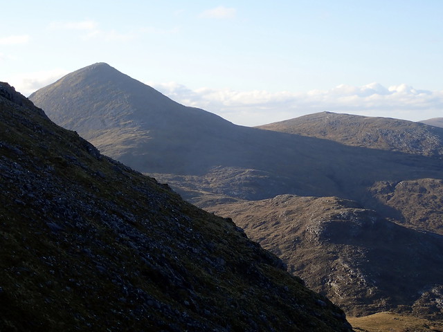
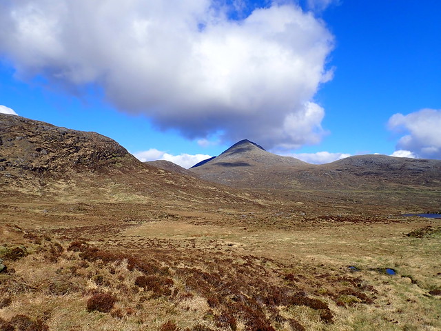
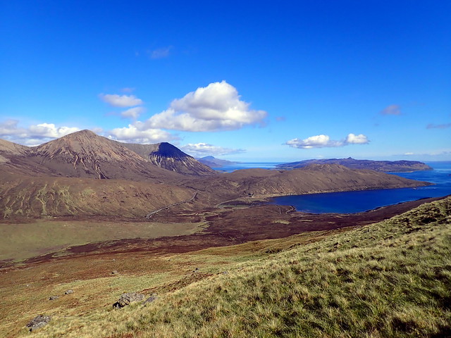
I was quite looking forward to climbing this pair again, even though it wouldn't count towards my current objective - although if I get round to a third Corbett round then it will have been money in the bank. Actually, anywhere on Skye, on a day like this, with a view to the Cuillin would be just dandy. We set off for Belig first, taking one of my "short-cuts" over the boggy ground to reach the Abhainn Ceann Loch Ainort and the scree slopes of Belig beyond. As we climbed, the dark mass of Bla Bheinn began to appear in the "V" between Belig and Garbh-bheinn, then as we climbed onto the saddle of the hill, the Cuillin Ridge reared up to our right - a fabulous day to be up there - every summit clear. I mentally noted the different parts of the ridge, including those of Sgurr na Bairnich and Bidean Druim na Ramh which have - so far - eluded my efforts to visit them.
Belig
 P5120180
 by
Al, on Flickr
Bla Bheinn in the background
 P5120182
 by
Al, on Flickr
Glamaig/Raasay
 P5120183
 by
Al, on Flickr
 P5120185
 by
Al, on Flickr
Drool
 P5120186
 by
Al, on Flickr
 P5120187
 by
Al, on Flickr
 P5120190
 by
Al, on Flickr
Continuing onto the airy summit of Belig the attention was split between the fine view of The Ridge and the equally impressive, darker view of Bla Bheinn and Clach Glas behind us. We dropped down towards Bealach na Beiste and paused for lunch out of the chilly wind which had suddenly appeared making A think twice about her choice of shorts for today. Pressing on up the boulder strewn slopes of Garbh-bheinn we got great views over to the imposing pinnacle of Clach Glas - another "not done it, probably never will" summit. On both previous occasions I've been up here the views have been poor, today was a superb opportunity to see what would be involved in trying to traverse Clach Glas - indeed there was a group of three climbers doing just that as we watched. We reached the summit of Garbh-bheinn, having passed a couple with a dog who looked a bit unsure of the best way down, and then enjoyed the airy little scramble across the summit ridge to reach the scree and boulders of the northern shoulder. As it was such a glorious day I was keen to prolong it and suggested we might head over to Marsco from Druim Eadar na Choire - A was less enthusiastic - something about "work tomorrow"...We ended up just returning to the car in the usual way - Marsco can wait - maybe as a tag-on to the Beinn Deargs when we're back to do the Grahams.
Summit Belig
 P5120192
 by
Al, on Flickr
Clach Glas/Bla Bheinn
 P5120193
 by
Al, on Flickr
Sgurr nan Each
 P5120194
 by
Al, on Flickr
An egg of the rare Kiwi-fruit bird, only seldom found on these islands
 P5120195
 by
Al, on Flickr
Last week we were in Knoydart looking over to Skye - now the reverse!
 P5120197
 by
Al, on Flickr
 P5120198
 by
Al, on Flickr
Clach Glas
 P5120200
 by
Al, on Flickr
 P5120201
 by
Al, on Flickr
Summit Garbh-bheinn
 P5120202
 by
Al, on Flickr
 P5120203
 by
Al, on Flickr
 P5120204
 by
Al, on Flickr
I will have dreams about this
 P5120205
 by
Al, on Flickr
Floating Eigg
 P5120206
 by
Al, on Flickr
 P5120207
 by
Al, on Flickr
 P5120208
 by
Al, on Flickr
 P5120210
 by
Al, on Flickr
The Beinn Deargs
 P5120211
 by
Al, on Flickr
 P5120212
 by
Al, on Flickr
I find it a little vexing to leave Skye when the sun is shining, even knowing there's a lengthy drive ahead of us. I just think about all the rainy, claggy days that have been spent up here and the difference that sun and clear skies make. But I guess it is a matter of just trying to Get Lucky next time as well - though if "the schedule" is to be followed, we won't be back on Skye til next year

