walkhighlands

Share your personal walking route experiences in Scotland, and comment on other peoples' reports.
Warning Please note that hillwalking when there is snow lying requires an ice-axe, crampons and the knowledge, experience and skill to use them correctly. Summer routes may not be viable or appropriate in winter. See winter information on our skills and safety pages for more information.

The alternative Dalmally horseshoe

The alternative Dalmally horseshoe


Postby BlackPanther » Thu Sep 19, 2019 5:55 pm

Route description: Beinn a' Bhuiridh, near Loch Awe

Munros included on this walk: Stob Daimh

Corbetts included on this walk: Beinn a' Bhuiridh

Date walked: 07/09/2019

Time taken: 8.5 hours

Distance: 17.4 km

Ascent: 1295m

4 people think this report is great.
Register or Login
free to be able to rate and comment on reports (as well as access 1:25000 mapping).

I can't believe summer's gone! And with it, any chance of climbing new Munros. With only 22 left, all our choices are either big walks, possibly overnighting trips (Knoydart, Lurg Mor) or hills situated 3 or more hours drive away from home, so now it's time to concentrate on repeating our nextdoor favourites in autumn conditions. I love autumnal Torridon in particular, as long as weather smiles, it's the best place to be in September/October :D

But this TR won't be about Torridon, but about an alternative horseshoe we had in mind since spring. I'd call it "the Alternative Cruachan circuit" but as it doesn't include Ben Cruachan, it would be better named "Alternative Dalmally horseshoe". We didn't invent this route, it had been described in several WH reports before, but we liked the idea of combining Stob Daimh with Beinn a'Bhuiridh from the very first time we had a look at the map of this area.

There was a second reason for doing the alternative route. We are seriously considering Ben Cruachan as our final Munro, so we wanted to get the sidekick Stob Daimh out of the way. And as the alternative also involved ticking off a new Corbett... Why not?

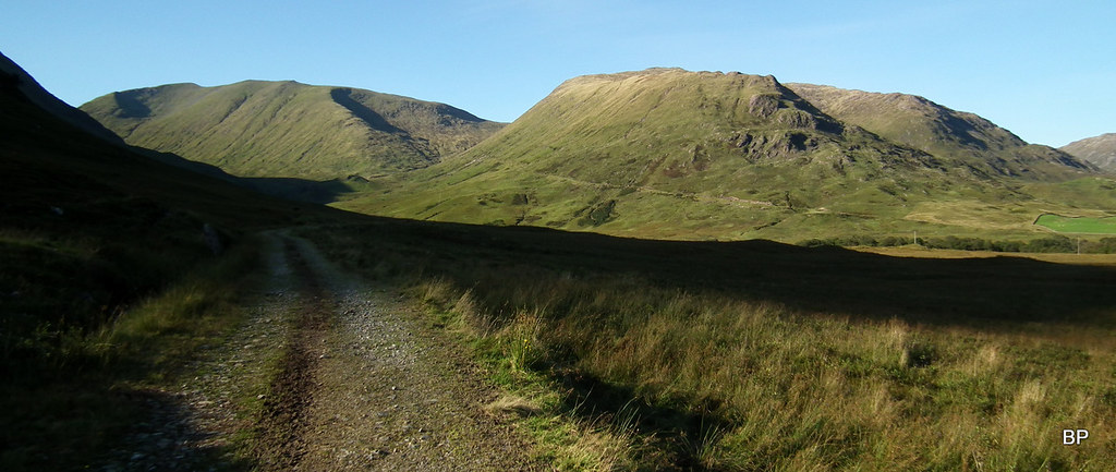
Our route begins from the B8077 (the usual starting point for Beinn a'Chochuill and Beinn Eunaich). When we arrived the local road was already very busy - dozens of cars parked in every possible off-road spot. We had to drive to the bridge over Allt Mhoille, where we managed to squeeze into a small layby. Our route followed the track on the western side of the glen (the old access track to now disused led mines). We then crossed the river and climbed the SE shoulder of Sron an Isean, traversing to Stob Daimh and then following the ridge to Beinn a'Bhuiridh. The descent route was by the long, eastern ridge of the Corbett (the original WH route for Beinn a'Bhuiridh only).
This combination is a nice easier alternative to the classic Cruachan round, but it still involves nearly 1300m of ascent and some steep sections (no scrambling but the final ascent to the Corbett is very tricky in wet conditions).

Track_STOB DAIMH 17,4 KM.gpx Open full screen  NB: Walkhighlands is not responsible for the accuracy of gpx files in users posts


On the track to the old mines (our target ridge walk behind us):
2019-09-07 stob daimh 007.JPG

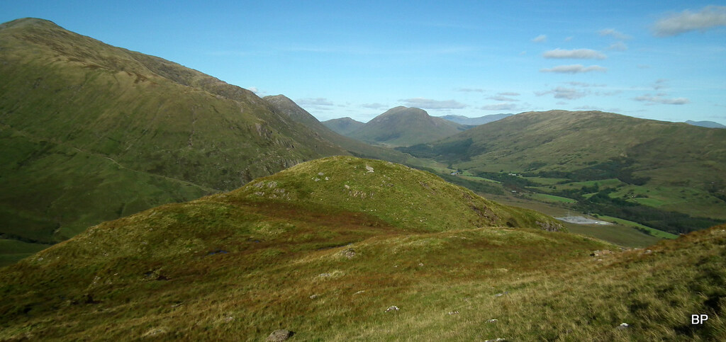
Panoramic view of Glen Mhoillie, Beinn Eunaich to the right, Beinn a'Chochuill in the middle, Sron an Isean to the left, plus a typical Scottish encounter of the moo kind in the foreground :lol:
2019-09-07 stob daimh 011.JPG

Are you going up a new Moooonro?
2019-09-07 stob daimh 012.JPG

The glen is full of grazing highland cattle, so if you plan to take a dog on this walk, be sure to keep it on the leash. The cows were not aggressive, more curious, but they still had young calves with them, so care should be taken.
From all descriptions I could find, I assumed there was a bridge over Allt Coire Chreachainn. It is not marked on the right spot on the 1-25k map and it's not visible from the main track, but after a short march across a boggy pasture, we found it:
2019-09-07 stob daimh 016.JPG

The lower slopes of the long SE ridge of Sron an Isean are quite steep, but all crags can be avoided and the ground is mostly covered with grass and low heather. Not much bracken, to my surprise.
2019-09-07 stob daimh 020.JPG

I had no breakfast in the morning to avoid the travel sickness and as soon as we hit the steeper ground, I hit the brick wall! My muscles felt so weak I could hardly lift my legs...
2019-09-07 stob daimh 023.JPG

Having gained about 200m, I said no more of that! Please, give me something to eat!
I sat down on the first rock I spotted and rummaged through my ruckscak, devouring anything even remotely edible :lol: :lol: Climbing with empty stomach is possibly the worst experience I had on the hills (not counting walking down an icy slope with a big hole in my knee). At least today I had enough sugar with me to make me hyper!
2019-09-07 stob daimh 041.JPG

TBH who wouldn't go hyper with such fantastic views around?
2019-09-07 stob daimh 045.JPG

After the initial steep push, the higher part of the ridge is more gentle and there is even a faint path to follow:
2019-09-07 stob daimh 039.JPG

Looking down the SE ridge from near the summit of Sron an Isean:
2019-09-07 stob daimh 047.JPG

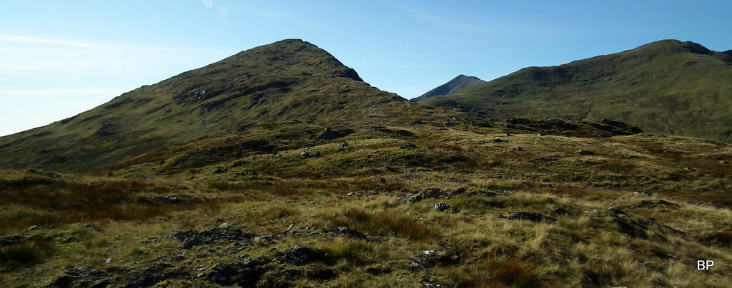
At 966m, Sron an Isean is a Munro top and a fantastic viewpoint. Kevin appreciated the beauty of the surrounding landscape, but he was eager to reach the summit of Stob Daimh:
2019-09-07 stob daimh 198.JPG

Panoramic view of Ben Cruachan and Glen Noe:
2019-09-07 stob daimh 060.JPG

Beinn a'Chochuill and Beinn Eunaich:
2019-09-07 stob daimh 064.JPG

View south-east:
2019-09-07 stob daimh 202.JPG

An obvious path links Sron an Isean to Stob Daimh, an extra 100m of ascent but the slope is easy enough:
2019-09-07 stob daimh 069.JPG

Lucy on the summit of her 119th Munro!
2019-09-07 stob daimh 216.JPG

Kevin busy photographing:
2019-09-07 stob daimh 217.JPG

Facing Ben Cruachan - not planned today, but it will be done at some point. Maybe as a final M!
2019-09-07 stob daimh 084.JPG

At the moment we had to satisfy with adding one new Munro (260 for me, 261 for Kevin) to our tally:
2019-09-07 stob daimh 213.JPG

View north to Loch Etive:
2019-09-07 stob daimh 206.JPG

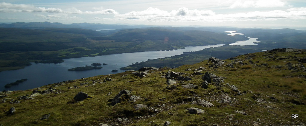
The Cruachan reservoir and Loch Awe:
2019-09-07 stob daimh 085.JPG

After a well deserved break on the summit of Stob Daimh, we continued to the intermediate top, Stob Garbh:
2019-09-07 stob daimh 086.JPG

...which offers even more interesting views to Ben Cruachan:
2019-09-07 stob daimh 090.JPG

Ok, I know this is a good spot to take pictures, but we still have a Corbett to do...
2019-09-07 stob daimh 097.JPG

Panoramic snap of Ben Cruachan and Coire Cruachan:
2019-09-07 stob daimh 098.JPG

Zoom to Ben Nevis:
2019-09-07 stob daimh 100.JPG

We stopped on the lower shoulder of Stob Garbh (947m) to admire the vertical cliffs on this side:
2019-09-07 stob daimh 109.JPG

...and pose with the superb views to the east and south:
2019-09-07 stob daimh 116.JPG

Zoom to Ben Lui:
2019-09-07 stob daimh 117.JPG

...but our main target was Beinn a'Bhuiridh. I knew that adding this top to Stob Daimh required clambering up a very steep slope, so I scrutinized the wall, looking for the best route:
2019-09-07 stob daimh 119.JPG

Scary as it looks, this slope is much less problematic than one might suspect. It is basically a very steep slog, mostly on grass, a little on scree, occasionally on hard rock. If maneuvering carefully, all scrambling can be avoided. Because it had rained heavily the day before, we preferred to go up this slope than try to descend it (this was the reason for doing the circular anticlockwise) and soon we discovered that the ground was waterlogged in places. We took time, making sure we didn't slip on the wet grass:
2019-09-07 stob daimh 233.JPG

Up the final ascent with Ben Cruachan in the background:
2019-09-07 stob daimh 125.JPG

The higher you climb, the steeper it becomes:
2019-09-07 stob daimh 243.JPG

Looking down the northern slope of Beinn a'Bhuiridh, to Lairig Torran and Stob Garbh:
2019-09-07 stob daimh 242.JPG

The Cruachan horseshoe in panoramic mode:
2019-09-07 stob daimh 128.JPG

Walkers on the summit of Stob Daimh:
2019-09-07 stob daimh 133.JPG

After the steep slog up the final slope, it was a relief to reach the summit of Beinn a'Bhuiridh, our 163rd Corbett (106th for Lucy):
2019-09-07 stob daimh 134.JPG

Many walkers, especially those on a Munro quest, disregard this Corbett as a boring sidekick of the Cruachan group and not really worth the hassle. What a misjudgement! Beinn a'Bhuiridh is a cracking viewpoint and on such a nice sunny day, it would be a sin not to stop here for longer!
2019-09-07 stob daimh 245.JPG

A few snaps from the summit:
2019-09-07 stob daimh 250.JPG

The tops we just walked:
Image2019-09-07 stob daimh 142 by Ewa Dalziel, on Flickr
Loch Awe:
Image2019-09-07 stob daimh 143 by Ewa Dalziel, on Flickr
Panoramic shot of Ben Cruachan:
Image2019-09-07 stob daimh 146 by Ewa Dalziel, on Flickr
The Cobbler and Beinn Ime:
Image2019-09-07 stob daimh 138 by Ewa Dalziel, on Flickr
Ben Lui:
Image2019-09-07 stob daimh 137 by Ewa Dalziel, on Flickr
Beinn a'Bhuiridh has two tops, the western one being the true summit, but we visited both, just in case:
Image2019-09-07 stob daimh 165 by Ewa Dalziel, on Flickr
Loch Awe once more - what a view:
Image2019-09-07 stob daimh 157 by Ewa Dalziel, on Flickr
And this is the ridge we will use in descent - looks cracking!
Image2019-09-07 stob daimh 169 by Ewa Dalziel, on Flickr
I actually tuned out a bit more wet than we expected :lol: but the going was all right all the way down to Monadh Driseig, which has a trig point, but we didn't bother detouring to it as it was getting late.
Beinn a'Bhuiridh from Monadh Driseig:
Image2019-09-07 stob daimh 176 by Ewa Dalziel, on Flickr
My favourite view of the day - like seen from the air. Glen Orchy and River Orchy, framed by Ben Lui and Beinn a'Chleibh:
Image2019-09-07 stob daimh 177 by Ewa Dalziel, on Flickr
Kilchurn Castle:
Image2019-09-07 stob daimh 180 by Ewa Dalziel, on Flickr
A wider pano of the eastern end of Loch Awe. Shame we didn't have time to visit the ruins (Kilchurn Castle closes at 5:30):
Image2019-09-07 stob daimh 182 by Ewa Dalziel, on Flickr
Looking back to Beinn a'Bhuiridh (left) and Stob Daimh (right), The ridge in the middle could be used as an alternative route of descent if skipping the Corbett:
Image2019-09-07 stob daimh 188 by Ewa Dalziel, on Flickr
The last 200m of descent gave us a headache, it's really wet and squelchy, but it was a small price to pay for a fantastic ridgewalk we enjoyed earlier!
Image2019-09-07 stob daimh 190 by Ewa Dalziel, on Flickr
We hopped over the boggy ground to join the old mine track near the remnants of one of the mine buildings (I guess). From here, there is a nice view into Coire Cheachrainn:
Image2019-09-07 stob daimh 192 by Ewa Dalziel, on Flickr
Beinn a'Chochuill and Beinn Eunaich from the track on the way back:
Image2019-09-07 stob daimh 195 by Ewa Dalziel, on Flickr
As our final new Munro this year, it was as good as it could be. Fantastic weather, great views, superb ridgewalking. Some bog fighting on the way down, but it didn't spoil the day. I can recommend this route for those who would like to climb Beinn a'Bhuiridh and prefer to make it a challenge rather than a simple walk up and down the eastern ridge.
...........................
I have finally caught up with my reports (it took ages!) but I hope I'll have another story to write next week as the coming weekend is looking interesting, we will be out and about for sure :D
Last edited by BlackPanther on Sat Oct 19, 2019 6:10 pm, edited 1 time in total.
User avatar
BlackPanther
Mountain Walker
 
Posts: 3841
Munros:268   Corbetts:182
Fionas:136   
Sub 2000:76   
Joined: Nov 2, 2010
Location: Beauly, Inverness-shire

Re: The alternative Dalmally horseshoe

Postby tweedledog » Fri Sep 20, 2019 10:37 am

Really glad to see that you enjoyed Beinn a'Bhuiridh. I live locally and always recommend Beinn a'Bhuiridh to those whom I meet doing the much bagged pair of Beinn a'Chochuill and Beinn Eunaich. It's a lovely hill and only 58ft below the much vaunted Munro altitude. And, as you say, a splendid viewpoint.

I'm curious, though, as to why you thought the track was for lead mining. Have you a source for that? My understanding is that it was built in the late nineteenth century for the granite quarries of which there are several scattered across the hillside. They were linked by various tracks (still traceable) as well as that main one that you walked on, and the building that you passed was part of the quarrying enterprise. I'm not entirely sure which tumbledown building it was that you saw, but one structure clearly housed some kind of machinery for conveying the granite down the hillside. If you look across from the slopes of Beinn Eunaich you can see where that system ran. Did you descend past the flooded quarry? That used to be the end of the track, but six years ago they bulldozed it further up into Coire Glas to build a hydro intake. It's possible to climb from the end of the new track up the steep head of Coire Glas to join your route on Lairig Torran. I reported an aborted version of this route here:

https://www.walkhighlands.co.uk/Forum/viewtopic.php?f=9&t=37451

Again, glad you enjoyed my favourite local hill.
User avatar
tweedledog
Wanderer
 
Posts: 327
Joined: Jan 20, 2013
Location: Argyll

Re: The alternative Dalmally horseshoe

Postby BlackPanther » Fri Sep 20, 2019 2:12 pm

tweedledog wrote:I'm curious, though, as to why you thought the track was for lead mining. Have you a source for that?


I admit I didn't do much research, but had a look on geograph.uk, this photo:
https://www.geograph.org.uk/photo/2104836
suggested it's "a lead mine quarry"
and this one https://www.geograph.org.uk/photo/2104779
calls the rubble on the slopes "Spoil Heaps from the Old Lead Mine"
the third one https://www.geograph.org.uk/photo/2104748
says the track is for "the old Lead Mine on the Allt Coire Ghlais"
So I just assumed the tracks were for lead mines. Maybe I shouldn't trust geograph so much :wink:
Also this photo: https://www.geograph.org.uk/photo/2104863 shows the remnants of the building in Coire Cheachrainn, describing it as "the old lead mine".

We descended much further into Coire Cheachrainn, leaving the quarries to our right, mostly because the ground was very wet and waterlogged so we preferred to stay away from the steeper slopes. Kevin noticed one of the old tracks, now overgrown with vegetation and even wondered if it was perhaps a dismantled tramway (like the one near Fersit).

Anyway, we enjoyed the circuit very much and will be back for more, possibly the classic horseshoe in the future.
Cheers
BP
User avatar
BlackPanther
Mountain Walker
 
Posts: 3841
Munros:268   Corbetts:182
Fionas:136   
Sub 2000:76   
Joined: Nov 2, 2010
Location: Beauly, Inverness-shire

Re: The alternative Dalmally horseshoe

Postby tweedledog » Fri Sep 20, 2019 3:21 pm

That's really interesting BP. In the local histories I've looked at I haven' come across any suggestions that those were lead mines. I think there's no doubt that the track we're discussing was the route of the Ben Cruachan Quarry Branch Line which functioned from 1885 to 1916 to carry granite down from the Ben Cruachan Quarry. See among many internet entries
:
https://www.railscot.co.uk/locations/B/Ben_Cruachan_Quarry/

Entertainingly, there's an entry elsewhere on Geograph which includes a picture of the main quarry area and the track, as well as a map. Here it is identified correctly as a granite quarry.

https://www.geograph.org.uk/photo/4845622

The claim that it is the remains of lead mining turns up here and there that I've found (often walk reports, but even in The Scotsman), so I wonder if the same claim has been picked up and repeated in the way of such things. While there has been lead mining in this area - I think largely between Dalmally and Tyndrum - I can't find independent evidence that there were lead workings in this location earlier than the granite works. May have been, of course, but it's certainly the case that the railway branch along that track was built to carry granite. If you ever go to Dalmally station there's a splendidly daft heron carved out of granite commemorating the once-upon-a-time local industry.

heron.jpg


Sorry to ramble on - the perils of being a retired professor...
User avatar
tweedledog
Wanderer
 
Posts: 327
Joined: Jan 20, 2013
Location: Argyll

Re: The alternative Dalmally horseshoe

Postby Blokewithastroke » Sat Sep 21, 2019 10:42 am

So, you say that the summer has gone. It doesn't look like it to me! Make the most of it!

Actually, I am rather curious when you say this is the last chance to climb further Munros this year. I get the impression that many people prefer to climb Munros and any smaller peaks outside of the summer months. I guess that this is because they don't have to escape the throng of the usual tourists at this time of the year.
Blokewithastroke
Mountaineer
 
Posts: 61
Munros:4   Corbetts:3
Fionas:1   
Sub 2000:2   
Islands:15
Joined: Oct 19, 2014

Re: The alternative Dalmally horseshoe

Postby dogplodder » Sat Sep 21, 2019 8:11 pm

I often get ideas from your reports BP - and this looks a good one! :D
User avatar
dogplodder
 
Posts: 4251
Munros:242   Corbetts:74
Fionas:26   
Sub 2000:32   Hewitts:4
Wainwrights:9   Islands:24
Joined: Jul 16, 2011

Re: The alternative Dalmally horseshoe

Postby EmmaKTunskeen » Mon Sep 23, 2019 8:20 am

Lovely report, as ever, and with your usual helpful info :D All the viewpoints look superb and definitely worth the walk and the linger. Love the shots of Loch Awe!
User avatar
EmmaKTunskeen
Mountain Walker
 
Posts: 348
Munros:32   Corbetts:28
Fionas:12   Donalds:14
Sub 2000:4   Hewitts:50
Wainwrights:41   Islands:24
Joined: Aug 19, 2016
Location: was West Sussex, now Ayrshire

Re: The alternative Dalmally horseshoe

Postby Klaasloopt » Tue Sep 24, 2019 10:36 am

Hurray for alternative routes!
User avatar
Klaasloopt
Hill Bagger
 
Posts: 326
Munros:168   Corbetts:71
Fionas:13   
Sub 2000:22   Hewitts:49
Islands:11
Joined: Jan 13, 2011
Location: Santpoort-Zuid, The Netherlands

Re: The alternative Dalmally horseshoe

Postby BlackPanther » Fri Sep 27, 2019 4:14 pm

Many thanks, everyone :D I hope my description will provide useful information for those of you looking for something different than the classic round-the-dam option.

Blokewithastroke wrote:I am rather curious when you say this is the last chance to climb further Munros this year.


What I meant was, we will not climb any NEW Munros this year - the ones we have left (22 altogether) require a very long day, an overnighter or are too far from home. The Arrochar Alps, for example, are 3-3.5 hours drive each way from Inverness so it would be more sensible to leave them for summer holidays.

We are happy to do Munros all year round, including proper winter conditions, but they will all be repeats :wink:

tweedledog wrote:Sorry to ramble on - the perils of being a retired professor...


No problem :D I did my bit of scientific research when writing my thesis so I know the feeling!
Interesting to read more about a subject I had no time investigating in detail. I think it's so easy to pick a misleading information (especially if it's repeated in many sources). We live in the era of fake news, even an old quarry track fell victim to it :lol: :lol:
Regardless of what it was used for, it's an interesting addition to Beinn a'Bhuiridh itself.
User avatar
BlackPanther
Mountain Walker
 
Posts: 3841
Munros:268   Corbetts:182
Fionas:136   
Sub 2000:76   
Joined: Nov 2, 2010
Location: Beauly, Inverness-shire

Re: The alternative Dalmally horseshoe

Postby dogplodder » Sat Oct 19, 2019 10:52 am

Any idea why your photos aren't showing? I'm eyeing up the Dalmally Horseshoe so went to see them again and they've gone! :o
User avatar
dogplodder
 
Posts: 4251
Munros:242   Corbetts:74
Fionas:26   
Sub 2000:32   Hewitts:4
Wainwrights:9   Islands:24
Joined: Jul 16, 2011

Re: The alternative Dalmally horseshoe

Postby BlackPanther » Sat Oct 19, 2019 3:59 pm

dogplodder wrote:Any idea why your photos aren't showing? I'm eyeing up the Dalmally Horseshoe so went to see them again and they've gone!


Sadly, most of my TR's are now useless due to a big Google bug. Not my fault. I'm not the only one affected. Details in this thread:

https://www.walkhighlands.co.uk/Forum/viewtopic.php?f=1&t=93014

I am slowly reviving them but it will take time to get through over 200 TR's. It all started with photos from 2017-2019 vanishing, but a few days ago I noticed also 2016 reports are now infected. I now expect them all to vanish and since re-doing everything is an enormous task (over 500 reports), all I can do is kindly ask for patience!

I'll make this one a priority so you can use the info :D
User avatar
BlackPanther
Mountain Walker
 
Posts: 3841
Munros:268   Corbetts:182
Fionas:136   
Sub 2000:76   
Joined: Nov 2, 2010
Location: Beauly, Inverness-shire

Re: The alternative Dalmally horseshoe

Postby dogplodder » Sat Oct 19, 2019 5:04 pm

Oh BP that's a horrible thing to happen. Are we all vulnerable to this bug? I'd be gutted if that happened to mine as it's all the memories that go with them. Please don't do anything on my account. I'm so sorry. :thumbdown:
User avatar
dogplodder
 
Posts: 4251
Munros:242   Corbetts:74
Fionas:26   
Sub 2000:32   Hewitts:4
Wainwrights:9   Islands:24
Joined: Jul 16, 2011

Re: The alternative Dalmally horseshoe

Postby BlackPanther » Sat Oct 19, 2019 5:25 pm

dogplodder wrote:Oh BP that's a horrible thing to happen. Are we all vulnerable to this bug? I'd be gutted if that happened to mine as it's all the memories that go with them. Please don't do anything on my account. I'm so sorry.


Don't worry, I have to repost everything anyway, so just as well do this one first :wink:

The bug only affects people who (like me) store photos in Google Photos. As long as you upload yours straight to WH server, you're safe :D

I'm currently moving all pictures from Google to WH and Flickr, but as I wrote above, it's a painstakingly slow job. Hopefully all my TR's will be restored in a couple of months.

***This TR has now been fixed.
User avatar
BlackPanther
Mountain Walker
 
Posts: 3841
Munros:268   Corbetts:182
Fionas:136   
Sub 2000:76   
Joined: Nov 2, 2010
Location: Beauly, Inverness-shire

4 people think this report is great.
Register or Login
free to be able to rate and comment on reports (as well as access 1:25000 mapping).


Can you help support Walkhighlands?


Our forum is free from adverts - your generosity keeps it running.
Can you help support Walkhighlands and this community by donating by direct debit?


Return to Walk reports - Scotland

Who is online

Users browsing this forum: No registered users and 239 guests