free to be able to rate and comment on reports (as well as access 1:25000 mapping).
I’d booked a self-catering place in Aviemore for the week of my birthday. But toward the end of that week, I was having such a great time, and the weather was rather cooperative, so I arranged to stay for a second full week. “*
There’s* your silver lining (with regards to not having a job),” says my little brother when he called—belatedly—to wish me a happy birthday. And he’s right!
I’d had a to-do/wish list that included Corbetts, Grahams, and a few sub2Ks in the area. I walked every day, I think, bar one. I sometimes didn’t go very far, or very high (or either), but I believe there were only a couple of days that I didn’t at least get my 15K steps. Evie joined me on three different days, and we managed to discover three Grahams that more than hold their own weight (height?) against many Munros in terms of character, toughness, and views.
Although I’ve written about events as I've gone along, it’s just now occurring to me (toward the end of the trip) how tortuous it’s going to be to add the photos. I took many. Sigh.
Sat 09 Nov
journey up the A9
Graham: Creag Ruadh (Dalwhinnie)
(nearly Munro): Meall Chuaich
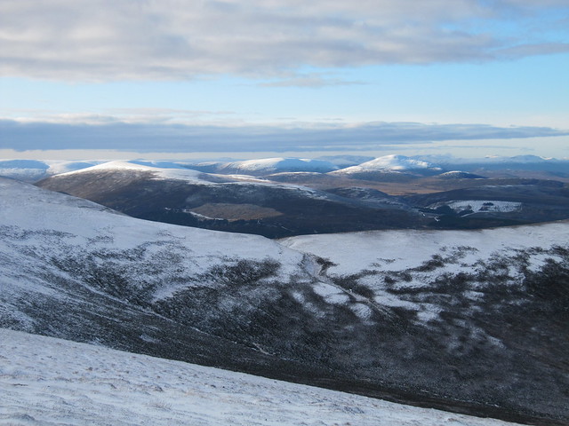
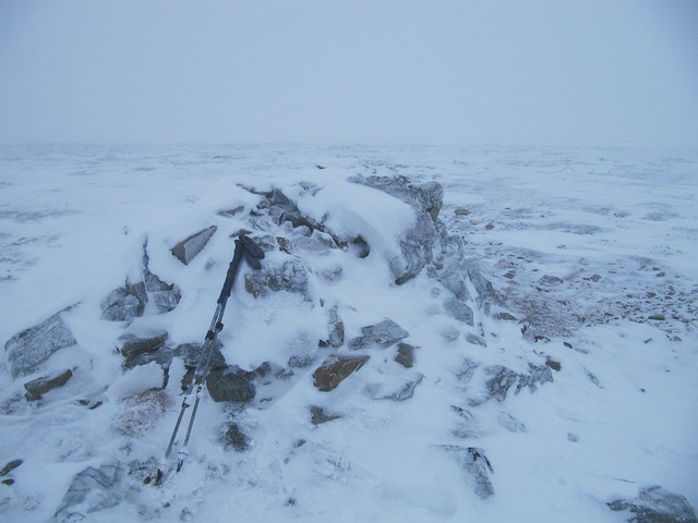
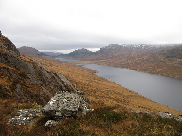
6 hrs / 20.7 km / 947m I set off just a bit after 10am, after having had a surprisingly good run up the A9. The weather was much better than had been forecast, and both this walk, and Beinn Mholach (from Dalnaspidal) had been on my radar. I decided though, that if I did the longer Beinn Mholach, I’d be racing against the clock all day, and I find that to be very stressful. I curse (again) my eyes!
By doing a walk nearer Dalwhinnie, I’d a) have various options, and b) be that much closer to Aviemore. It only took me an hour and a half to reach the summit of Creag Ruadh (11:30). It’s a fabulous viewpoint—in all directions!—and I spent a few minutes revelling in them, and taking photos in various directions.

The Fara, from the ascent

across to Meall Chuaich

Cairngorms; my ridge route lies ahead

zoom to Creag Meagaidh, The Window featuring prominently
OK, it’s decision time. Do I carry on along the ridge, over various bumps, as far as Druim nan Sac (and even a bit beyond) before dropping down to the track that would carry me back along the east side of Loch Cuaich (hm, different spelling for the loch and the hill; wonder how that came about)? Or do I descend more or less the way I’d come, and pay another visit to Meall Chuaich? Would I have time to do both? (greedy girl!) A faint landrover track along the ridge beckoned. Reluctant to descend whilst the views were so glorious, I opted to stay high. It was a lovely romp, and I was enjoying myself.

passing squall

but then back to blue sky; looking down Loch Cuaich
I reached the little hunting bothy at the end of the loch at 1pm. I’d decided to do a time check there before deciding whether to continue up the Munro, or head back to the car. I couldn’t check into my accommodation until 4pm, so I still had some time to kill. I couldn’t remember how long it had taken me to summit MC (many years ago), but gave myself a hard turnaround time of 2:30pm, and headed up the hill. It was a long slog. One guy that I met told me I “didn’t have far to go,” but added that once you reached the point where you thought the summit should be, there’s just a little further to go. I reached that point (where I thought the summit should be) at 2:30. I could see that there was further to go, but I couldn’t see the summit cairn. It probably would have been only another 10-15 minutes to the summit, but that’d put me as much as a half hour behind schedule. It’s a HARD stop, innit? I was a bit disappointed to turn back knowing I was so close, but honestly, I’d had a great day.

and back to dark clouds again -- I think this is in the general direction of the Ben Alder hills, but not far enough around (they'd be behind The Fara); so these must be Drumochter hills? They seem to have too much interest/character, tho…
It was a few minutes after 4pm when I got back to the car. By the time I changed my shoes, darkness was well on its way. I’d forgotten that I was quite a bit further north, thinking that I had until 5pm or so; it (darkness) lands at more like 4:30. It was dark by the time I got to Aviemore, and therefore had to look for the cottage I’d rented in the full dark. It was a bit of a pain in the derriere, as the directions weren’t very good. Anyway, I finally found the bloody place and settled in, showered, had some dinner, made a plan for the next day, etc. It’s a nice enough place, I suppose, but way too frou-frou for my taste; knick-knacks, fairy lights, and faux candles on every surface. A crappy shower, but a big bath. Tiny kitchen. But it’s within walking distance to Pizzariach, a Co-Op (SO much more convenient than the Tesco!!), and the Cairngorm Brewery, to which I will be paying a visit.
Sun 10 Nov
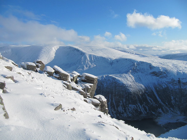
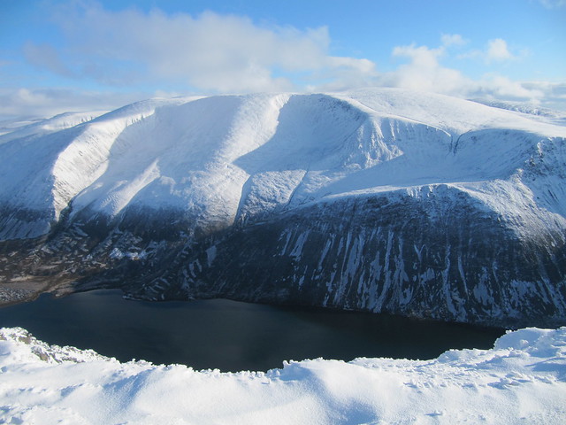
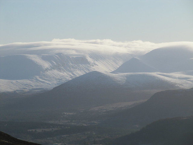
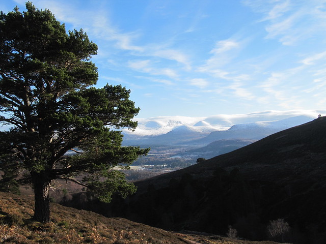
Munro: Sgor Gaoith
6 ½ hrs / 17.15 km / 1096 kmI thought I’d had one of the best days ever yesterday, but today was extraordinary—one of those amazing (winter) days that will live long in memory. Another fabulous forecast, and I’d decided the night before that, although I have plenty of Corbetts and Grahams (and even “lesser” hills) on my list for the week, it was going to be far too good to NOT go up high.
I’d decided to leave from the small NR car park rather than from Achlean; the last time I’d done this hill, I’d also done Mullach Chlach a’Bhlair, and approached it using a different route. I quite liked the look of this WH route, giving the option of traversing along the ridge and descending from Geal-charn rather than returning via the same route.
It was an absolutely stunning morning, and the colours and the snowline on the surrounding hills reminded me of several Colin Prior photos. Mine won’t look anything like his!

I think this is in the general direction of Glen Tilt... but I really just like the photo...shaping up to be a golden day!
I ain't no Colin Prior!

slog to get here! but at least I can see the summit.
It was a long hard slog from about 700m; the soft snow deep in places. It took me more than three hours to reach the summit. But oh my goodness, the views made it all so worth it. Looking across to Braeriach was especially stunning. There were a couple of lads who reached the summit about the same time, and we took it in turns posing on the summit for photos.
oh, wow


It was off, then, for me, having decided that I not only wanted to come down via the ridge, but that I also wanted to “nip out” (haha) to Sgoran Dubh Mor.

summit cairn, Sgoran Dubh Mor

back down out of the snow, near the path
This return route meant a lot of extra up and down, and my legs got quite weary. Then it was a very steep descent through deep heather (and snow) back to the path, which I was very happy to reach. I returned to the car at 2:30, after a thoroughly satisfying expedition!
the Coop seriously needs to take these off offer!
Mon 11 Nov
Corbett: Geal Charn (Dorback)
4½ hrs / 13.8km / 538mWell. This was meant to be an easy outing, but it ended up being anything but. After having two pretty big days previous, I wasn’t quite ready for a full rest day, but I did want an easier day. This one fit the bill. Or so I thought. I’d had a leisurely morning, walking into the village centre to get a few bits. The morning weather wasn’t bad (the views across to the Cairngorms were spectacular, with high clouds and lots of fresh snow; I didn’t have my camera with me).
I left the house around 9am; it took me more than an hour to find the start point, after getting thoroughly confused in Nethy Bridge, and ending up joining the A95 to Grantown—no worries, I’d wanted to check the price of petrol there anyway. It was the same as in Aviemore, and the station was heaving, so I carried on, back toward Nethy Bridge. Good heavens, this area confuses me! At any rate, I finally found the minor road leading to Dorback, and followed it for a good 5 miles before finding the large turning area that marked the start. I set off walking at 10:15, intending on doing a straight up and back, rather than the WH circular, but soon realized, without having paid close attention to the map, that the track I was following was actually the WH return route. Oh, well. I’d also forgotten to put my contacts in, which later became an annoyance, when the snow came on, and I got overheated during the descent—I couldn’t see anything!

easy so far
But first things first. Following the track to its high point was no problem, but soon after leaving it, I was in clag, and snow, and the world was white. The soft snow became deeper and deeper, and the walking more and more tortuous. I seriously considered turning around several times, but knew I was fairly close to the summit. I spent a bit of time wandering around, without a clue as to where I was, or where the summit might be. A lone fence post pointed me in the right direction, and I eventually found myself at the large quartz summit; quite pretty in its winter coating of snow and ice.
from yesterday's sublime to today's ridiculous


I was going to return the same way, but because the descent route followed a fence line for some distance, decided to follow that instead. It was less distance, too, than my outward route. Yeah, well, the fence line wasn’t quite as useful as I anticipated, given that it currently consists mostly of fallen-over posts and the odd bit of wire sticking through the snow here and there. I went wrong, and found myself descending in the wrong direction. I corrected, and soon found a slightly better version of the fence I’d meant to be following.
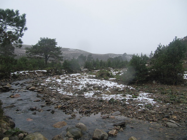
a nice spot, actually (bar the wet snow falling) near the Braes of Abernethy; this burn needed crossed, but no prob today
I eventually found my way down to the track that led me past the ruins at Upper Dell, across the river (there’s a certain freedom that comes with performing a ford when your feet are already sloshing!), and finally back to the car. It had begun snowing quite heavily during my descent, and I was soaked through, and chilled to the bone. It was a much more tiring expedition than I’d anticipated! But I was glad that I’d carried on to the summit. The forecast for tomorrow doesn’t look so good; might be time for a (well-earned, imo) rest day!
Tues 12 NovShite weather all day. I mooched around the shops for a while, had a second breakfast at Costa, bought groceries I didn’t need, and got my fringe trimmed. That’s pretty much it.
Wed 13 Nov
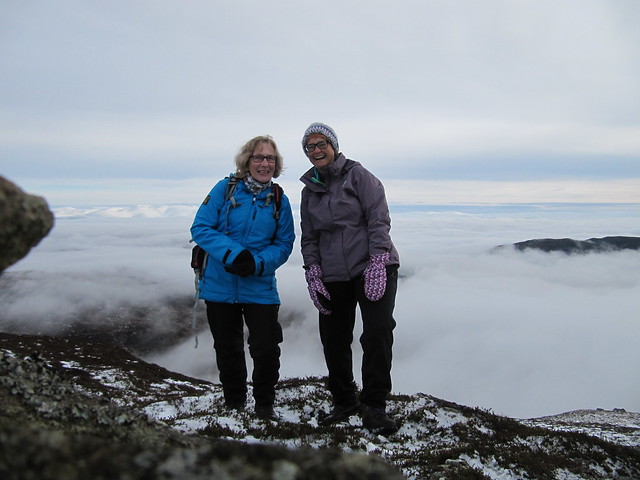
Graham: Creag Dhubh (Newtonmore)
4 ½ hrs / 7.75km / 533m Last year, I climbed Suilven on my birthday. THAT was going to be hard to top, even though I hadn’t gotten any views from the top. The forecast for today was pretty good—dry, anyway—but there was a freezing heavy mist clinging to Aviemore as I drove through on my way south to Newtonmore. Evie had suggested doing a traverse of the Creag Dhubh ridge, leaving one car at the end, near the Banchor cemetery.
It was still misty when we set off up the hill. But there were bits of blue poking through, and occasional glimpses of surrounding tops.

hm...it might clear... our summit's somewhere up in that direction...
We eventually found ourselves above the mist, and started marvelling at the view across to the Monadhliath hills, the Creag Meagaidh massif, and further, to the Ben Alder hills. There were some pointy hills in the even further distance; Evie thought they might be the Grey Corries, but we couldn’t pick out the smaller and pointy Stob Ban. We eventually decided that it didn’t really matter!

When we reached the ridge, the splendiferous snow-covered Cairngorms suddenly and very dramatically appeared; they’d keep us company for most of the rest of the walk. Above the mist that clung stubbornly to the lower levels, there was sunshine and blue sky in abundance. Glorious!

oh, wow


We sat for a few minutes near the large summit cairn, but a bit of an icy wind had kicked up, and we cooled down fast. It wasn’t long before we were on our way again, following a good (though lethally icy in places) path back toward Newtonmore.


(Evie's photo)
(I really am trying to limit the number of photos, but I'm struggling!)
There’s a lovely oak (I think) wooded area on the lower reaches of the hill. Then it was through a fence onto a farm track, a brief detour to the A87 bridge over the River Calder, and back to the car.
A fabulous walk in stunning conditions with great company, followed by coffee and cake at Wild Flour, followed by a pizza-by-Pizzariach dinner (and a beer, of course). Quite possibly the best birthday ever! Today might even—but only by the slightest nose—have topped last year’s birthday Suilven.
Thurs 14 Nov
Graham: Carn glas-Choire (near Carrbridge)
3 ¼ hrs / 13.5 km / 441mFor all intents and purposes, there’s a track all the way to the top of this hill, making it a good winter walk when there might or might not be views. It was another cold and frosty morning; and I drove like the little old lady I am to the start point. The main road out of Aviemore had definitely been gritted, the minor road to Carrbridge may or may not have been, and the tiny B road toward Forres had definitely NOT been! But I got there without incident, and parked up just down the road from the track leading to Auchterteang and beyond.

from the start point, looking across an icy B road toward my target hill
The long walk (~4km) across the moor was really quite pretty, and I was having a grand time. The Cairngorms remained ensconced in heavy cloud cover, and the top of my own hill was intermittently in and out of it.
I entertained myself by following (snow)rabbit tracks here there and everywhere, and big splotches where they’d stopped for a nibble.
I poked my nose into the “green hut” bothy. I’d stop there again on my return, sit on its porch and eat my sandwich whilst enjoying the sun on my face.

the green bothy

looking back down the track
There’s not much more to tell, really. Follow the track until it more or less ends, but then pick up a faint landrover track that leads cleverly around the peat hagginess and to the trig point/shelter cairn at the summit. I didn’t get far-reaching views across Speyside, and all the way to the Moray Firth, but I could see a windfarm in that general direction. Yay.

approaching the summit

summit team photo
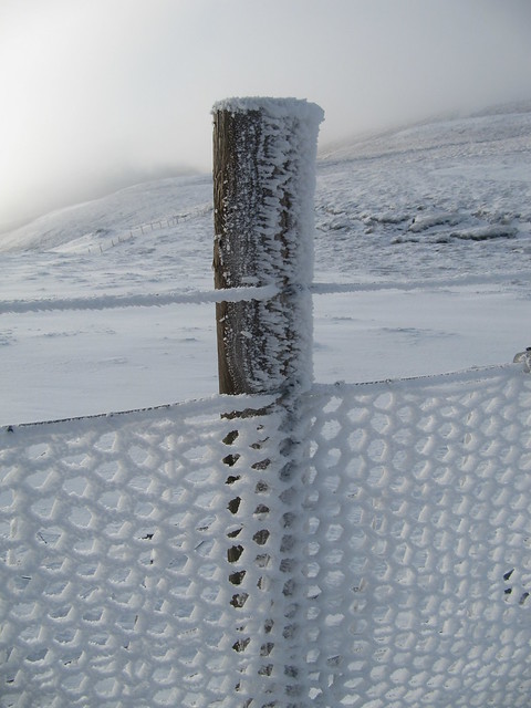
frozen fence
It was very cold, and a bit breezy, so I didn’t stick around before heading back down the track.
Sometime during the night before, I’d had the idea that maybe I could extend my stay in Aviemore. Ah, the joy of retirement; I didn’t *need* to go home for anything (except one appointment that could fairly easily be rearranged), and when I checked, my accommodation hadn’t been booked by anyone else. So when I got back from this walk, I called the management company, and made the necessary arrangements to stay for another entire week. Woohoo!
Fri 15 Nov
recce on the Cromdale Hills
2 ¾ hrs / 10.8km / 428mI’d already scaled down my original plan; malky_c’s route taking in both Grahams along the Cromdale Hills ridge was over 18km. Although he’d done it in an evening, in just under 3½ hours, I knew I wasn’t up to covering nearly 6km an hour (nb: I don’t know whether I’ve *ever* been able to go that fast, even in trainers on the flat!). I’d decided to follow the WH route to climb only Creagan a’Chaise, leaving the shorter route to Carn a’Ghillie Chear for another day.
Although the temp was somewhat milder today, there was still lying snow along the roads, so there was no question that there’d still be even more up in the hills. The forecast was for high clouds, light wind, and good visibility.
HA. I set off in the mist. I’d already delayed my departure by an hour or so, because when I left the house, it was actually raining. So I had another coffee and a bacon roll after picking up a few bits and pieces at Tesco. It had stopped raining by the time I reached Cromdale, but I couldn’t see my hill (or much else, either). Nonetheless, I set off, hoping that the mist would dissipate as I ascended.

not too promising

posh grouse butt
It didn’t. Although the blue sky seemed to be “just up there,” the mist didn’t shift. And it kept raining; not particularly hard, but enough for jacket and rucksack cover. I decided that I’d keep going as long as there was track to follow, and reassess once I’d reached the end of it. With the milder temps, the snow was soft and slushy, and very slippy. Hard going, as there was still even the odd patch of ice here and there. I decided that I’d make the go/no-go decision when I reached the cairn at the 635m point. By then, most of the climbing would be done, but it was still an additional 2km to the summit. Based on my experience on the Dorback Corbett a few days’ prior, I knew that progress over that largely featureless terrain would be slow and stressful. About 100m away from the cairn, the rain started again in earnest, making my decision rather easy.

it started raining soon after I took this photo
I returned to the track below the grouse butts, and closed a circular loop by following that track past the Haughs of Cromdale battlefield, and returning to the minor road I’d walked in on. I wasn’t fussed that I’d not made the summit; I’d had a nice walk anyway.

an abandoned cottage I'd like to have the money to buy and restore...
Sat 16 Nov
Graham: Creag Liath (Glen Banchor)
4 ¾ hrs / 13km / 503mEvie picked me up around 9; we set off walking 45 minutes later (9:45). The morning was misty, much like it had been a few days prior when we’d done Creag Dhubh together, but much milder, and it wasn’t long before we stopped to divest a layer.

you can kind of see our hill at this point...
It stayed clagged in as we walked up the track, crossed the shoogley bridge (with a repaired handrail, however), and began the “ascent proper,” although we’d actually been gently ascending as we marched along the track. At no time was it difficult; just a steady climb. We could see a summit ahead of us, and I just assumed that that was THE summit. I was wrong, we still had about 800m to go, and another ~100m or so of ascent.

it's starting to dawn on us that it just might clear...

and VOILA!
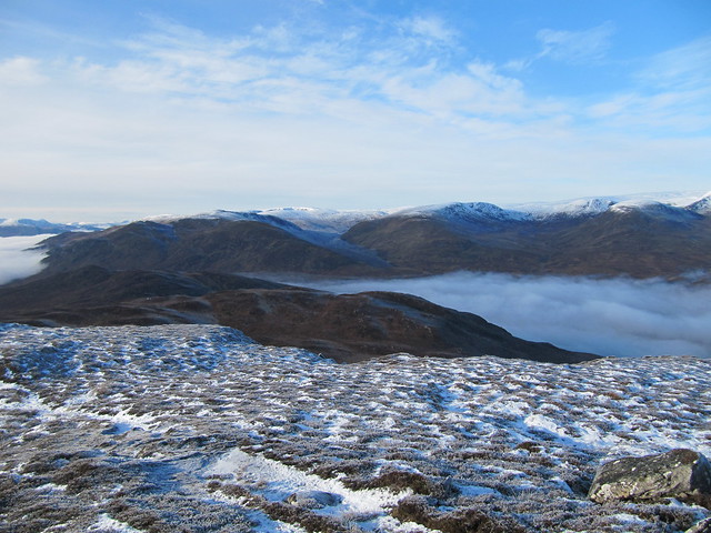
But, astonishingly, for the second time in only a few days, we managed to catch another spectacular inversion! Carn Dearg (of Monadhliath fame) was just across the way; Creag Dhubh was just across the other way; and BAM, once again, there were the snow-covered Cairngorms, in all their glorious glory. Wow, wow, wow, we said. Again. How lucky are we? Must be all that righteous living.


Our original plan was to descend steeply down the SE face of the hill directly from the summit. But neither one of us liked the way it looked—or rather the way it didn’t look, in that it was one of those “dropping of the face of the earth” views, so we agreed, both quite happily, to simply retrace our steps. We rounded off yet another spectacular day with cake and coffee, this time at the Sugar Bowl, in Kingussie.
Sun 17 Nov
Craigallechie (why ISN’T this a hill of some classification??)
~3 hrs / 12km / 362m It was a fairly grotty day, weather-wise, and I left from the house just wanting to get some fresh air and exercise. I didn’t really have a plan, and I was travelling light. Including without camera, so there aren’t any photos.
Before I’d reached the village centre, I’d decided that I wanted to have a wee nosy around the Craigallechie NNR, near the YH. I kept following the “viewpoint” path as it climbed steeply up onto a ridge that carries along for some distance beyond the official viewpoint to the summit of Craigallechie. It was quite squidgy in spots, and you wouldn’t have known that the Cairngorms were even “over there” for the cloud cover. The rain/sleet/wet continued intermittently, but not miserably so.
This walk is one of those wee gems that you’ll never discover if you’ve only driven to Aviemore to do a big walk. It’s a very pretty walk up to the summit, through lovely birch trees that were, today, still hanging onto some of their leaves. The downside is that you’re never away from the noise of the A9.
I followed my nose back down the hill, and back into the village, where I realized that I was rather peckish. I treated myself to a late lunch at the Balavoulin (which sounds much more like a distillery than a restaurant), next to the Winking Owl. It was pretty good. But not cheap.
Mon 18 Nov
Corbett: Geal-charn Mor (finally!)
7 hrs (one in the pub) / 22.5km / 856mBest day ever! (a phrase that’s going to totally lose meaning unless I stop saying it!) I can’t quite believe that I’ve been so very fortunate with the weather during my extended stay. If this keeps up, I’m not going to ever want to go home!
I set off from the flat at 8:30am. I’d decided that I didn’t really need to drive to the start point; walking to it would extend the day somewhat. I also had a vague notion of returning over Craigallechie; I’d noticed on the map that there was a track that led to the wee lochan that I’d seen from the viewpoint cairn.
I’d read a walk report that mentioned a tunnel under the A9 near the Italian restaurant at the roundabout at the south end of Aviemore. The same walk report made mention of a path on the other side that led to Lynwilg. I found the tunnel; I didn’t find the path, so simply walked along the A9. There was a very wide verge to begin with, but it progressively narrowed until it became unpleasant. Thankfully, the narrowest bit didn’t last too long, and it was with some relief that I marched up past the new distillery toward Alltnacriche.

how many pheasants can you spot?
Then it was onto the Burma Road (a through route to Carrbridge) under blue cloudless skies and sunshine. I was a happy girl, out in yet another glorious day, even wearing contacts today (I’ve had to ration them, as I generally only bring one pair per day when I’m away), so I could see!!

this is actually the gate I'll go through on my way back (toward Craigallechie)

I kept taking photos (directly into the sun) toward various Cairngorm hills

zoom to the Lairig Ghru

turn left here
It was an easy walk up the track to the large cairn at its high point. From there, it was only about a km across the snow to the summit.
The views across to the Cairngorms captivated me, and I took many photos (I may actually be in danger of filling the storage card; something that’s never yet happened—note to self: bring the little doohickey when you go away so you can upload them!).

the views are actually better on the way up/down, because the summit is so broad
I sat on the summit for perhaps 15-20 minutes, revelling in the view and basking in sun that was actually quite warm off the reflecting snow. The tomato soup I’d brought hit the spot. I eventually and reluctantly dragged myself away, and headed back down the track I’d come up.

tall and skinny in shadow!
I became obsessed with taking photos of several large and magnificent Caledonian pine trees on the descent

I found and followed the track that lead to Lochan Dubh, just below the viewpoint cairn at Craigallechie. I was a bit worried about fencing that lead from both sides of the lochan, but it was only waist-high and easily crossed.

the lochan below the Craigallechie viewpoint
From the viewpoint, it was a straightforward (and familiar, since I’d just done it yesterday) return to Aviemore’s main drag. I couldn’t resist stopping into MacDui’s for a pint before reaching home at 3:30. A(nother) most excellent day!
Tues 19 Nov
Exploring Upper Glen Feshie
5 ¼ hrs / 20.4km / 356mA very very cold start to a day that never did get very warm; but at least it was dry and clear again. I set off from the car park at Achlean at 9:45am.

I think I must be going that way...

first burn crossing (from the gate that takes you onto the Glen Feshie estate)
There’s a very good track all the way to the Ruigh-aiteachain bothy, except for the huge amount of flood damage at the ford that’s a bit more than a km before the bothy.
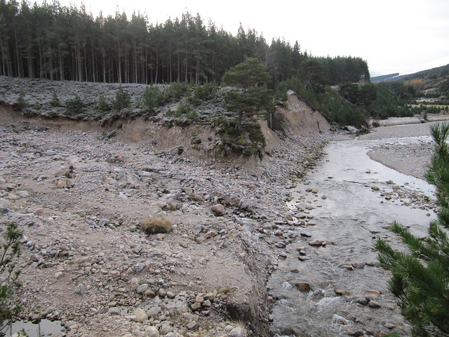
the well-made path ends abruptly, and you need to make your way across this to pick it up on t'other side
I poked my nose into the empty bothy, which is quite posh and tidy. I wouldn’t mind staying there, tbh. There are two large rooms downstairs, with a woodburning stove that straddles them both; sleeping platforms, and a cosy loft-type space on the upper level. I hope that all future users take care of it.


Even beyond the bothy there’s a good path that follows the river, quite closely at times. There are some cracking camping sites under large native Caledonian pines.

looking across the river toward the track that leads (eventually) to several remote Corbetts

the tree obsession continues
I carried on for about 3kms beyond the bothy, to a place that’s marked as An Cagain on the map; about a half km short of Ruigh Chreagan. I’d set a turnaround time of noon, but I’d also reached a section very close to the river that got a bit dicey. There appeared to be a bypass path, but it headed quite steeply uphill, and was rather icy. Even if I’d made it up, I’d not have wanted to come back down it!

my turnaround point
I simply retraced my steps back to Achlean; the return journey was uneventful (and pleasant), but when I reached the ford at the place where the path has been washed away, I heard an odd noise. It took me a minute to figure out what it was, but it was quite a lot of rubble—and some rather large stones as well—that were falling away from the badly eroded slope directly in front of me across the ford, and into the river. I watched, mesmerized by the spectacle, for a good 10-15 minutes, wondering if the entire hillside was in danger of slipping.

lots of rubble -- some of it quite large -- was falling from this sheer face
I returned to the car at 3:00pm, after yet another thoroughly enjoyable and satisfying Cairngorm wander.
Wed 20 Nov
sub2k: Beinn Mhor (near Grantown)
1 ¾ hrs / 6.6km / 261mPlan A had been another whack at the what-are-becoming-elusive Cromdale Hills. I’d decided to try the “other” one (can’t remember or be arsed to look up its name) today, but I also didn’t want to have another wandering around in the clag experience, so I told myself I’d see how the hills looked from a distance, and make the call then.
I’d woken up quite tired, and it was a challenge to drag myself out of the house; I could easily have stayed in all day. But the forecast, although not quite as sparkling as some previous days, wasn’t bad.
The clouds hovered close to the top of my target hill. I could see the summit when I neared Grantown, but it also looked like it could come down at any time. I binned Plan A and decided on Plan B, a wee hill up Glenbeg, its turnoff very close to the first Grantown roundabout.

I parked just before this bridge; I was reluctant to walk across it, nevermind drive!

gloomy clouds, bit o' sunshine streaming through
And it was wee. I was back at the car in under two hours, even after taking my time wandering around its broad summit. At least it stretched my legs!
Thurs 21 Nov
A Strath Nethy wander
Corbett: Meall a’Bhuachaille (again)
6 ¾ hrs / 22km / 827m I was away early today, setting off from Glenmore Lodge before 8am. I was going to have a wander up toward Bynack More to see what conditions were like. I didn’t really think that I’d make it to the top; I didn’t take my winter gear, and the forecast was for very strong winds (gusting to 60mph). I told myself that I’d try to get to the cairn that marks the turnoff for BM and make a decision there; carrying on toward the Fords of Avon was also an option.

the obligatory shot of Lochan Uaine
I didn’t make it anywhere near the cairn! By the time I’d reached only around 500m, walking had become “arduous” and unpleasant.

this very pretty lochan, surrounded by trees, was a bit off the beaten path, but I'd seen it from the track
I turned around and made my way to Ryvoan bothy, poked my nose in (no one home), and then carried on toward Nethy Bridge for a few kms. It was sheltered and pleasant walking through the forest. I turned around about 11am and made my way back to the bothy.

zoom toward Bynack More looking mostly clear. I still wouldn't want to be up there, given the wind!
I’d decided to go over Meall a’Bhuachaille on my way back. It looked fairly benign—I expected it to be gusty, but there wasn’t too much snow. It was slippy in places, both on the way up and on the way down the other side, but the worst of it was easily avoided. This is the third or fourth time I’ve climbed this hill; it’s a good ‘un for a quick leg stretcher and good views over the Cairngorms “proper.”

across to Cairn Gorm + friends, from the summit

there was a some marvelous otherworldly light (photo doesn't begin to do it justice) on the way down
I returned to the car at 2:30 after having a brief break at the Glenmore Forest Café (nachos, if you must know, winning out over coffee and cake).
Fri 22 Nov
Graham: Binnein Shuas
5 hrs / 11.5km / 547m Earlier in the week, Evie had thrown out the idea of the “Shuas/Shios” duo as an option for today. But we’d both had a look at various routes, and decided that doing both hills was going to be too long a day for this time of year. We’d pondered a couple of other options (another go—for me—at either of the Cromdale hills), or a sub2K near Tomintoul, but ultimately settled on taking on the larger (and nearer) of these two.
The weather wasn’t great when we set off; gloomy and showery. We marched up the track toward the hill, still undecided as to which route we’d take.

I love the view down Lochan na h-Earba

Evie’d suggested that we look for a “climber’s path” that headed up from the shores of Lochan na h-Earba toward the steep crags that loomed intimidatingly ahead. She’d read that there was a way up a grassy rake that was “steep but without difficulty.” (We joked—several times—that “one man’s ‘without difficulty’ was another man’s ‘no bloody way in hell can I do that’,” and hoped that we’d concur with the “without difficulty” end of the spectrum.)
gaining some height

nearing the point where the steep climb levelled out
Happily, the route we found *was* without difficulty. It was actually quite satisfying; the good news is that with a very steep ascent, you gain elevation quickly (duh). There were a couple of false tops, and the summit was well guarded by steep crags that we needed to find a way around.

summit!
There were good views, but nothing as spectacular as we’d had on our previous outings; the high tops remained in clag, and it was thus a bit difficult to identify the surrounding hills.

toward Laggan and the Shios that got away this time

general direction of our descent; also toward the Fersit hills (tho we couldn't see them)

Creag Meagaidh + friends are under there somewhere
We settled into a sheltered spot just below the summit to have a bite to eat, then made our way down over the rough ground that most of our WH compadres (there weren’t many) had used as their ascent route.

looking back up at a tough and knobbly "wee" hill!
We rounded out the outing—yet another Graham that punches well above its height—with coffee and cake at the Coffee Bothy in Laggan. Yum!
We were nearly to Aviemore when darkness fell (just after 4pm!) with the suddenness of a switch being flipped; I couldn’t get over how quickly the transition from daylight to half-light to total darkness occurred. And we’re still nearly a month from the solstice!
Sat 23 Nov
journey homeI packed up the car, tidied the flat, and was on my way doon the road by about 8:30am. Evie had asked me the day before if I was planning a walk on the way. I only had to think about it for a second before I realized that I was done. Done. Bone tired, but so very happy—on a real high—after spending two weeks in the heart of the Cairngorms.
