free to be able to rate and comment on reports (as well as access 1:25000 mapping).
I’d been looking forward to doing these two hills for a while and Stob Ghabhar did not disappoint. It was great to get off the busy A82 onto the single-track road toward Inveroran. Victoria Bridge car park was already full by the time we rolled up at 9:30am, and it was hard to tell who was heading up the hills and who was going for a wander along the West Highland Way.
We stuck our boots on and headed along the road to the lodge to join the track which heads for Glen Etive. There was a herd of Red Deer nestling in the long grass between the road and Loch Tulla, but to get a decent photo of them you’d need a better camera than that which I have on my phone.
The walk along the track to the green Clashgour hut makes a gentle start to the walk and got the old joints warmed up before anything too strenuous.

At the forest lodge you walk through a beautiful, albeit short stretch of old forest full of Scots pine, Oak and other native deciduous species. It would be great to see more of this kind of woodland on our hills.
Turning onto the track which runs alongside the Allt Toaig the path becomes faint and boggy in places. However, the boggy patches are not too deep and you can often find stones or clumps of grass to stand on. The gradient is gentle which made for a nice amble along in which we could soak in our surroundings and spot the path down to the side of the waterfall at Creag an Steallaire.
As soon as you ford the Allt Caolain Duibh turn right off the main path onto a path which rises quickly up the slopes of Stob a’Choire Odhair. The path zig-zags a fair and height is quickly gained. At about 750m the gradient levels off a good bit all the way to the summit.
I had thought these hills would be quite, and probably in comparison to others they were. There were two groups of people, a group of three and group of eight, enjoying the views when we got there. Despite it being sunny the wind was cold so as well as pulling lunch out our bags we also pulled out and put on our jackets.

(Bob at the summit of Stob a'Choire Odhair)
The group of eight left the summit before us and as they headed down the path we’d just come up I assumed that they were not pressing onto Stob Ghabhar. Having enjoyed lunch part 1 we set off for the beallach and the initially faint path was easy to find and follow. We spotted the group of eight at the beallach (668m point) so the must have swung off the other path fairly quickly to join the path we were on.
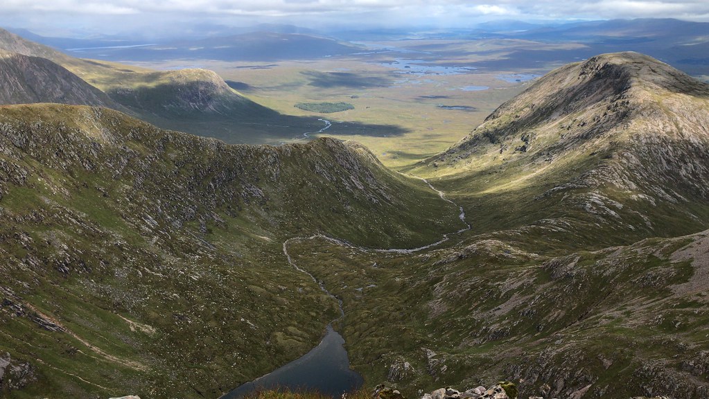
The clarity of the water in the lochan in the corrie was amazing, but your back is quickly turned to this as the assent up onto Aonach Eagach begins.

The path is quick loose in places and in poorer conditions it is easy to see how one might slip on this section. There are also a couple of sections where you cross some large boulders and spotting where the path runs beyond these takes a bit of care.
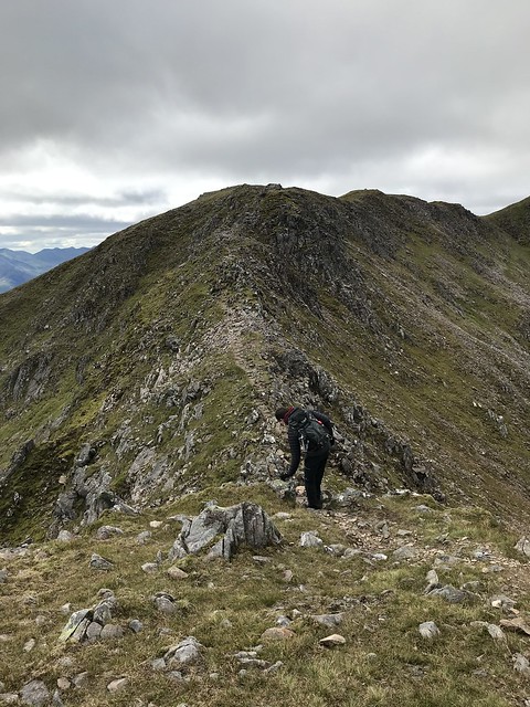
Once up on the ridge the views back to Stob a’Choire Odhair were great, and we put our jackets back on and gloves to keep the cold wind off. The ridge along to the summit of Stob Ghabhar was not as exposed as I thought and was very enjoyable. A decent cairn marks the junction with the path down. Bob, who was with me spotted a herd of red deer deep in Coire na Muic.
(At the start of the ridge)
The views from Stob Ghabhar were fantastic. Looking back toward Rannoch Moor the coire almost has an S-shape to it which made it look even more fantastic. We stopped for lunch part II and took some time to try and identify all the summits we could see, Cruachan to the South West and Bidean nam Bian and Stob Coire Sgreamhach looked particularly impressive.


(Looking toward Cruachan)

(Looking toward Bidean nam Bian)

(Bob enjoying lunch part II)
Having enjoyed lunch part II we headed back to the cairn which marked the way down our rucksacks a little lighter. The path down roughly follows a line of old metal fence posts. Unsurprisingly, the nearer you get to the top of the waterfall the boggier the path gets, but even with all the rain we have had recently this was far from the boggiest path I’ve even encountered. I was a little anxious about finding a spot to get across the Allt Coire an Muic with dry feet, but if you stick to the path then it brings you to a point which is fairly easy to cross. As the guide states the path then drops steeply and the views afforded of the waterfall are wonderful. I was also a little anxious about getting across the Allt Toaig dry, but the path drops down to where there are big stepping-stones which took us safely to the other side.

The walk out was a bit of a trudge. I’d put new insoles in my boots, and they had altered how my feet sat in my boots and not in a positive way. My feet were killing me, and I’d skinned the back of my heel again. Needless to say, the “new” insoles are now out of my boots and the old insoles are back in. However, I’ve taken so much skin off the back of my heel I think it will be several weeks before I can put boots back on without pain.
Even with the sore feet it was a great day. I think the view from Stob Ghabhar is among the best I’ve seen.
