free to be able to rate and comment on reports (as well as access 1:25000 mapping).
 Bheinn Mhor
 by
scotlandmac, on Flickr
I love the Hebrides and some of my favourite walks are island ones. We hadn’t been on Islay for around 5 years, most of our time being spent in the Western Isles so this lovely, soft southern island was on the agenda with 9 days holiday to plan. We had 4 nights on this wonderful island, wild camping for 3 nights of them on the beautiful, remote - feeling Ardnave Peninsula, a spot we had found before and loved.
 Ardnave Peninsula where we wild camped
 by
scotlandmac, on Flickr
I had a list of ‘must do’ walks as usual for any trip. As my husband Chris often says, he comes home from a holiday for a rest

Not that these were difficult or lengthy walks by any measure, but the terrain on Islay can be surprisingly tough and we did plenty of wading through knee deep heather over the next few days.
First up was Beinn Mhor and the Mull of Oa, a Nature Reserve and one of my favourite areas on an island full of beautiful corners. Spectacular cliffs, big ocean views, Ireland on the horizon and a chance to see Golden Eagles and Peregrine falcons, if we were lucky - that sounded pretty good for a gorgeous, already hot summer’s day.
The early sunrise that morning at the tent had been gorgeous with views to Scarba and Mull and even Cruachan's twin summits.
 P1090798.jpg
 by
scotlandmac, on Flickr
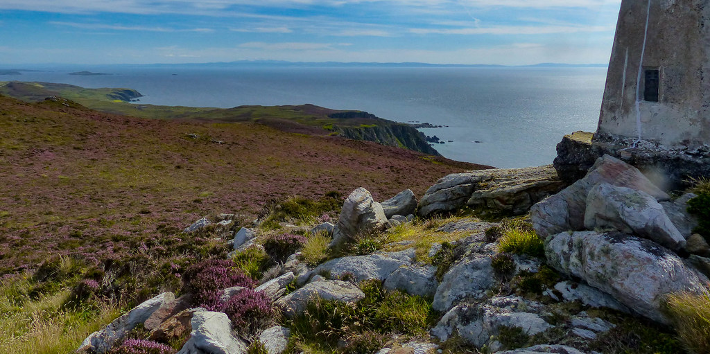
It was an hour’s drive from Ardnave to the end of the minor road at the Mull of Oa car park where at 10am, we were the first car. This is the start of the very popular, much shorter walk to the superb American Monument, a tragic but dramatically beautiful spot, as well as the beginning of the longer hike to the peninsula's highest hill.Its summit is a mere 202m , but it punches well above its weight in oceanic views and sheer loveliness.
‘A couple of hours,‘ I said to Chris, knowing he was keen for an easy, relaxed wander and somehow forgetting Walkhighlands description of the terrain ahead as ‘rough, pathless heather.’

It was 8.5km return, with a bare 250m of ascent. ‘Easy peasy,’ I assured him checking the time on the OS App on my phone, where I’d downloaded the route. But of course, it didn’t take into account terrain! We would NOT be doing this walk in anything like that time. However, in blissful ignorance we set off for our morning ‘stroll’ without a care in the world, as time spent on Islay (and any of the Hebrides) has a habit of making me feel. In fact, the well-known song 'Westering Home', which was written about the island, had been going round and round in my head since we'd arrived yesterday.
 Start of walk to Beinn Mhor
 by
scotlandmac, on Flickr
The route started on a good farm track, the verges filled with fragrant white Meadowsweet and dotted with the little lilac blue heads of Devil’s Bit. Montbretia was everywhere on Islay too, a riot of orange and red. And already, that sweet scent in the air, which I always associate with summer in the Hebrides. It was glorious already.
 P1100028.jpg
 by
scotlandmac, on Flickr
Having read Walkhighlands description of the route days ago (and somehow missing the suggested time it would take) we decided to do it in the opposite direction and get to the furthest point of the walk first – Beinn Mhor - rather than make for the Monument which was close by. I could see this small hill in what seemed a LONG way ahead, full of little knolls and dropping sharply to the sea. From here it was a hazy soft purple, absolutely clothed in heather of all shades. In fact much of the peninsula was just a sea of purple and pink.
 Bheinn Mhor clothed in heather
 by
scotlandmac, on Flickr
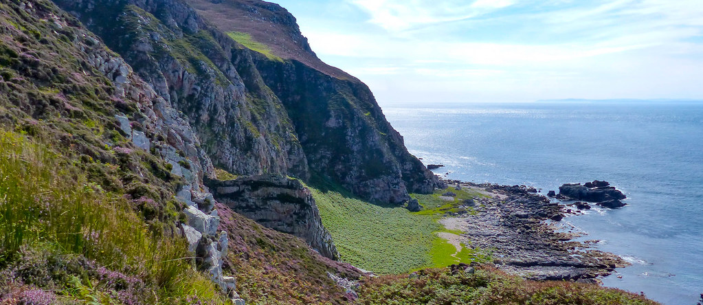
So off we set, through 2 gates, across a field and then a short boggy interlude as we crossed a burn on some wobbly planks. The terrain changed from emerald green to tussocky heather and bracken. I know it’s poisonous stuff but I love that sharp smell of bracken in summer and even the earthy smell of sheep too ( my peasant blood, Chris says.) Quite quickly, we had reached the cliffs and the first of several Geos or deep inlets, below which lay lonely pebbly beaches or grassy swards, ringed by cliffs and most with a steep route down. They all looked inviting but we stayed high, admiring the Aegean blue of the sea and the sight of Malin Head and the north coast of Ireland beginning to appear on the southern horizon(a bit too hazy in the photo to make out.)
 Lots of little bays below the cliffs
 by
scotlandmac, on Flickr
Beinn Mhor still looked a fair bit away so we decided to cut inland and on the return, follow the cliffs more closely to enjoy the views. There were paths all over the place which I assumed were made by sheep until we were assailed by the distinctive smell of Goat’s Cheese.
The smell of goats is NOT one of my favourites I will admit and it had got stronger with every step. Pulling my gaze away from the wonderful sea views, almost immediately half a dozen wild goats came into view, trotting nimbly through the heather. Very handsome with their long shaggy coats and impressively curved horns – a bit like Ibex and much nicer than the domestic variety. Their scent wasn’t quite as bad as their farmyard cousins either – maybe a heather diet had sweetened it

 Wild Goats alarmed by our presence
 by
scotlandmac, on Flickr
 Leader of the Pack
 by
scotlandmac, on Flickr
It was from this point on that the single – boot wide path we picked up began to really slow our pace. The views were stunning with the deep covering of heather on the hill set against the sparkling blue of the sea , mesmerising really but – OMG, not easy to walk through!

Every step meant lifting a foot high before placing it down, to avoid tripping. Nothing awful I know, but it did bring walking speed down considerably and the effort rating up by the same amount. And as ever when you feel you're not walking at a reasonable pace, we didn’t seem to be getting any closer to Beinn Mhor.
I have a bad habit of getting overly concerned with checking our time on any walk and after a quick glance at my watch, I was shocked at how slow our progress now was. So much for ‘goodbye to care’ on Islay – just ridiculous to fret about how long such a walk ‘should’ take.
It must be an age thing; as we are both in our 60s now, I find myself measuring whether our pace matches book times or not, as a way of monitoring fitness. I’m on a hiding to nothing over that of course in the longer term.

Saddled by care or not, the climb up the hill was absolutely gorgeous. Tough underfoot , but at a pleasant angle and truly beautiful. Some lucky white heather too ( a good omen indeed as amazingly, little did we know then, but 9 days of great weather lay ahead.)
 White Heather
 by
scotlandmac, on Flickr
A tiny wee hill, but oh the views of great cliffs plunging into the sea! And away to the south, the great inlet of Lough Foyle in Ireland which I had visited in 2019, almost a year to the day. Rathlin Island too and of course, well to the west, Malin Head itself.
The path became even more spectacular as we neared the summit, winding its way spectacularly above a steep drop before heading up the final easy slopes to the Trig Point.
 Hazy Ireland to the south
 by
scotlandmac, on Flickr
What a spot!
 View towards Kintyre and Arran from summit
 by
scotlandmac, on Flickr
 Ireland on the horizon and Rathlin
 by
scotlandmac, on Flickr
 Dramatic coastline of the Oa
 by
scotlandmac, on Flickr
The deep blue of the sea, the pinks and purples of heather, the emerald greens around Port Ellen to the south – and the American Monument, our final destination, sitting boldly on the highest cliffs of all on the Oa. Not a soul around, utter peace. The hum of a bumblebee on the heather, the faint sound of surf washing gently onto a rocky bay somewhere below. A magical place.
Plenty of comfortable flat rocks to perch on and enjoy gammon sandwiches and some much needed water. It was hot with barely a breath of wind. We spent around half an hour just drinking it all in. Arran’s lovely mountain profile lay way to the east, in a bit of a haze beyond Kintyre. Seeing Ireland so close really does emphasis how far south Islay lies. I had read that Islay and Ireland still have strong connections and contingents from both countries visit the other on certain Feast days. Looking out west to the ocean – next stop America.
Always tough to leave a summit, but pull ourselves away we had to do. Nice to be going downhill now and with even better views of the bays and pebbly beaches of the Oa.
 The coast opening up
 by
scotlandmac, on Flickr
Chris is drawn to cliff edges like the proverbial moth to a flame, while I always keep a bit back, being a Wee Feartie of the first water and before I knew it he had detoured to climb up the grass-topped rock stack that is Dun Athad. On the top are the remains of an ancient fort.
 Dun Athad and Chris on the top
 by
scotlandmac, on Flickr
I was happy to amble now, enjoying the wonderful coastal views until suddenly we were back at the wobbly wooden planks we’d crossed a couple of hours back. A short stiff pull up onto the last portion of cliff top took us to the final section to the 131m high American Monument itself, a fantastic but deeply sad and moving place.
 Near the Monument now
 by
scotlandmac, on Flickr
Other wildflowers had returned now – harebells and red clover, vetches and buttercups, all lending a lovely swathe of colour across the grassier terrain.
Standing admiring it all, my attention was caught suddenly by something flying very fast above us. A Kestrel? Chris got the binoculars on it and I tried to capture it on the camera - wow, a Peregrine Falcon! Unmistakable with the light coloured breast and barring and sheer speed. A male we reckoned. What a sight.
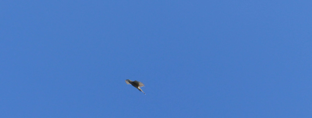 Peregrine Falcon
 by
scotlandmac, on Flickr
We had once joined a Guided Ranger walk out here to the Monument, a really interesting short wildlife walk during which the guide had pointed out to us , sitting almost invisible on the cliff face watching patiently, a male peregrine. Without the guide pointing him out, we would never have seen him, he was so brilliantly camouflaged.
The American Monument is a superb structure in itself, a fitting memorial to the tragedy of 2 Troop ships , the Tuscania and the Otranto, which went down off Islay in 1918 with the loss of 600 men. One foundered just off the Oa, the other at Kilchoman on the island’s north west coast. There is a beautiful , immaculate War Graveyard at Kilchoman where those bodies were not repatriated are buried, a site we visited on our next day’s walk.
 The tragic story of the Tuscania
 by
scotlandmac, on Flickr
 A fine memorial
 by
scotlandmac, on Flickr
We spent a while just sitting in the sun, the sea now sparkling in the afternoon sunshine and much more benign than it must have been on the awful dark nights that the ships went down.
Surprisingly weary legs took us back to the car on the excellent, constructed path.
 Boardwalk over the peaty ground on the return to the car park
 by
scotlandmac, on Flickr
I half expected Chris to say something about the ‘easy peasy 2 hour stroll’ not quite matching reality but he loved the walk and said he’d definitely do it again. Beinn Mhor itself is certainly an area of Islay few visitors ever get to and feels very wild.Another quick look at Walkhighlands description of the walk once we were back at the car (better late than never) revealed an expected time of 3 – 3.5 hours, so we were bang on pretty much. But really, it was pointless to care about that anyway on such a day and in such a place which deserved perhaps even more time than we gave it to enjoy and explore it all properly. Next visit - an explore of one or two of those beautiful lonely bays, banishing all thought of 'time taken' and being more faithful to the words of the song:
Westering Home and a song in the air
Light in the eye and its goodbye to care
Laughter o' love and a welcoming there
Isle o' my heart my own one...
