walkhighlands

Share your personal walking route experiences in Scotland, and comment on other peoples' reports.
Warning Please note that hillwalking when there is snow lying requires an ice-axe, crampons and the knowledge, experience and skill to use them correctly. Summer routes may not be viable or appropriate in winter. See winter information on our skills and safety pages for more information.

A boat trip, Sgurr na Stri to Elgol on Skye

A boat trip, Sgurr na Stri to Elgol on Skye


Postby ramblingpete » Tue Nov 29, 2011 10:26 am

Sub 2000' hills included on this walk: Sgùrr na Strì

Date walked: 02/10/2011

Time taken: 5 hours

Distance: 12 km

Ascent: 580m

6 people think this report is great.
Register or Login
free to be able to rate and comment on reports (as well as access 1:25000 mapping).

An 8 mile walk from Loch Coriusk landing steps, up Sgurr na Stri, down to Camasunary Bay and along the coast path to Elgol. (THE COASTAL PATH IS VERY EXPOSED IN PLACES)

This was one of those walks that gave everything to me – pure pleasure all the way. After seeing pictures from the top of Sgurr na Stri, I’d made my mind up to go and see the same view, hopefully when it was clear.

After a mixed week of weather and a couple of good walks (one with Ian Stevenson of http://www.mountainfreedom.co.uk/home.htm ) we headed down to Elgol for the last couple of days. I’d been hoping for a sunset or two and finally got one on the Saturday night, which bode well for the Sunday trip. Incorporated into this walk was a boat ride from the jetty at Elgol on the Bella Jane - http://www.bellajane.co.uk/ , chosen because it ran on a Sunday. I think the Misty Isle boat is run by the locals, but they must go to the kirk as they don’t go anywhere on the Sunday. It took 45 mins across flat water to reach the landing steps at Loch Coriusk, and on our way we had views of a basking shark, plenty of seabirds and of course the seals at ‘seal rock’. The boats hadn’t sailed across the loch for about 3 weeks due to the weather, so we were lucky to catch this one.

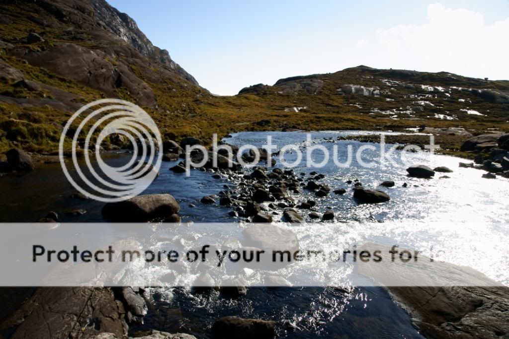
Low cloud topped the summit of Sgurr na Stri, but looking around I was sure that it would be clear later on. Halfway across the loch I realised that I had forgotten my sandwich, but thankfully had a few snacks to keep me going. After a stroll around the boggy shores of Loch Coriusk you quickly realise that this is an amazing place, surrounded by the jagged Black Cuillens, a stunningly beautiful place to visit, peaceful to the extreme in the sunshine. The dome slabs of Gabbro are easy to walk over and very ‘grippy’ as the surface of the rock is quite rough – fall on this stuff and you would know about it. There is a climbers hut nestled below the steep slopes, facing south and catching the sun – you need to be a member of a climbing group to use this though.

After returning to the landing steps and waving goodbye to the Bella Jane, I was alone in utter silence, no wind, just sunshine, with the clouds lifting above most of the summits. A short walk around the shore along what must be the shortest river in the UK – 0.2 miles – brought me to the stepping stones across the River Scavaig. I’d wondered about staying dry as the rivers and burns have been running in spate over the previous week, but it was nice and dry. With the aid of two walking poles for balance it was an easy crossing to the other side, then a steady traverse around the shore, gradually gaining ascent up towards the Allt a’ Choire Riabhaich – a small river that flows down the gabbro slabs from the loch above. I passed by a couple of deer, which didn’t seem to be bothered about my presence and let me snap away merrily. My camera doesn’t have much of a zoom, so I didn’t get much of a close up of these. As I got higher up the slopes behind me the Innaccessible Pinnacle came into view, almost lost amongst the higher jagged peaks.

Before I got up to the loch I decided to cut away from the main path and head up to Sgurr na Stri to the south. There are traces of paths here and there, mainly made by the deer – I didn’t find a regularly used path. The ground was ok, a mixture of gabbro slabs and boggy, grassy tussocks. It was quite energy sapping at times, but I’m sure most would find it reasonably easy. As I got higher and higher the views began to open up and I found myself stopping and staring over to the Cuillens an awful lot of the time. I was puffing away and literally bumped into a Stag. I spent a little time snapping away, me staring at him, and him at me, before he bellowed a couple of times and toodled off down the hillside. I met him again later on, when he did the same thing, obviously getting ready for the rutting season.

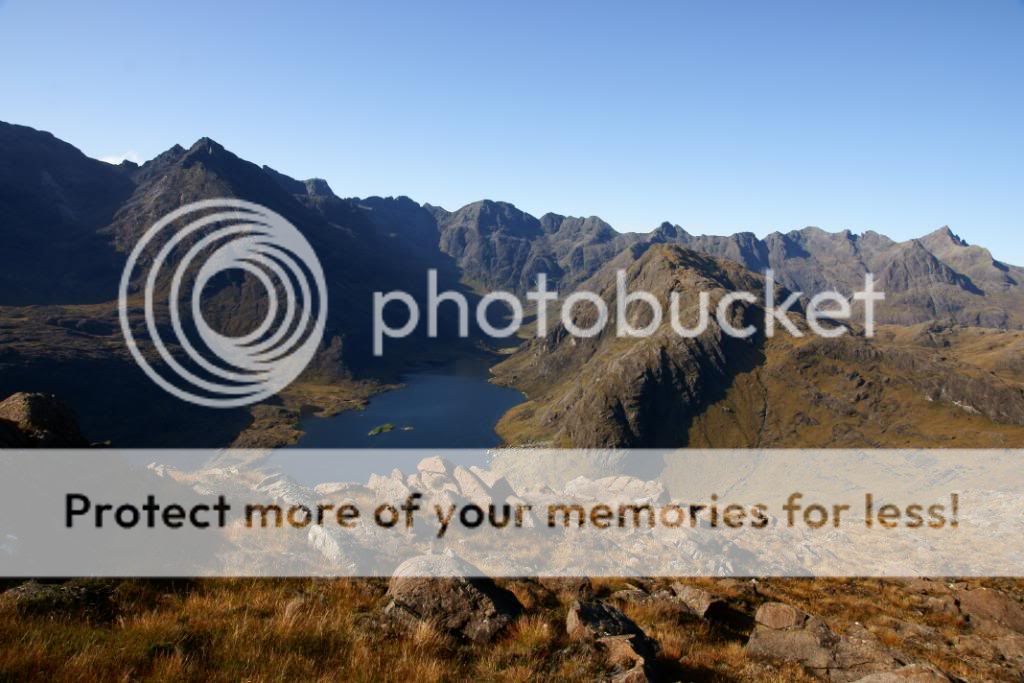
Eventually after much more ascent I came out at the top to what must be the best view in Britain – it’s outstanding and the vista takes in the whole of the Black Cuillen Ridge and a bit more beside. I wished I could have done it justice with my shots, but the afternoon sun shining into the lens put an end to that. It would be best to get up here earlier in the day for the best chance of capturing it’s beauty – I’ve stitched a couple together. The drop below your feet is steep which allows you to capture the beach and lochs below, as well as the high peaks. I could have stayed for hours, but I had a long walk down and back along the coast, so didn’t spend as long as I’d hoped – a good reason to return again.

For the journey off the mountain I’d downloaded a GPX track from the Walk Highland site, and a little scramble took me onto the right path / deer track. This veered to the NW below some crags and was quite a distinct path, again boggy and steep in places. At a grid ref of NG49993 20175 I started to drop down the slope, about a 1000ft to the river - Abhainn Camas Fhionnairigh – following the river bank to take me to another set of stepping stones. The river is quite shallow and is easy to cross, especially today on the dry rocks – again the walking sticks helped. After heavy rainfall it should still be ok to cross, but the water maybe a little higher up the leg

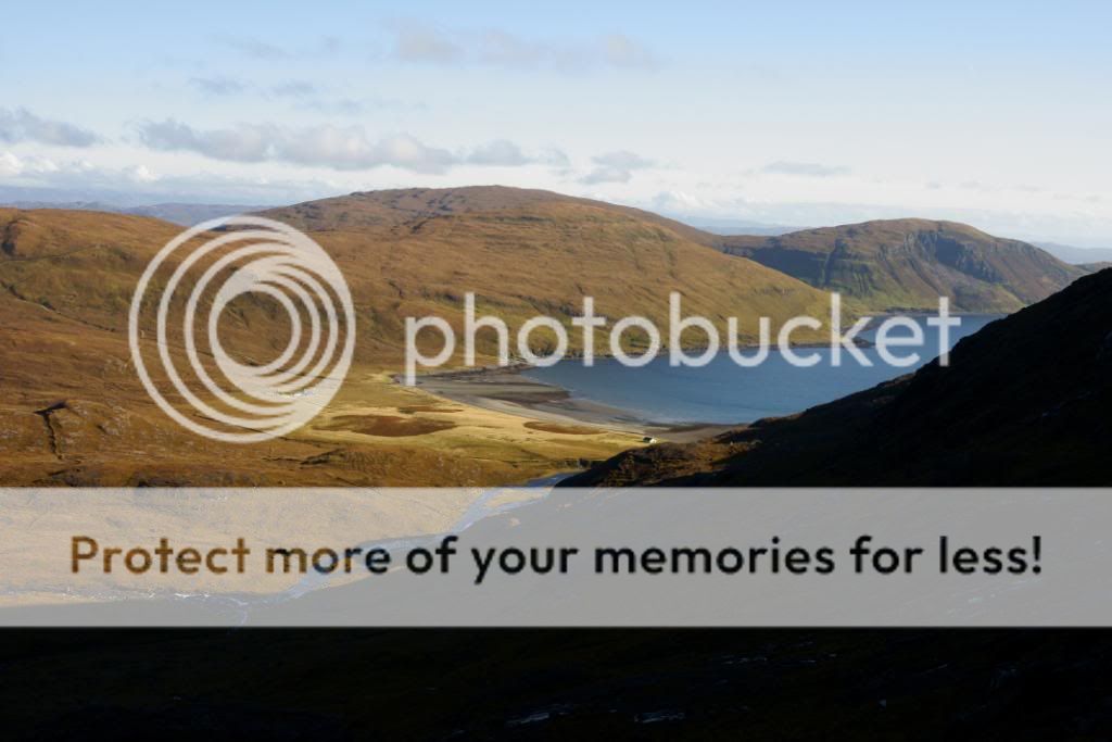
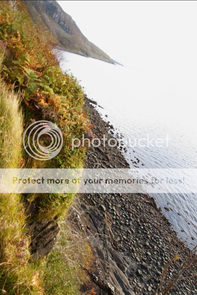
I was now down at Camasunary Bay, another peaceful spot with a beautifully situated bothy, that looks south out over a stony beach. I sat here and had a snack and a drink, conscious that time was ticking on. The ground behind the bothy looks ok, nice golden grasses swaying in the breeze, but like much of Skye it was very boggy. Two ladies had parked their trainers outside to dry and thought I was there to spend the night. They were busy tidying up and throwing away someone’s rotten fish. I knew that sunset was about 7:15 pm, the afternoon light was getting a nice evening glow to it, so I upped and got going again, a little unsure about the coastal route. I’d read a couple of walk reports, but no one had mentioned that it was very high above the beach, slippery and narrow - It’s about 4 miles to the road at Elgol. Thankfully Ian the guide had warned me a couple of days ago that I would have been better taking the track over the beallach at Am Nam and down to the road near Kilmarie. But I decided to give it a go as it had been dry all day and I wanted to stick to the coast and see the beach at Cladach a Glinne – this is the location where fossil turtles have been found, but I believe they have all been removed now. From the bothy the path took me across the bay towards another privately owned building, by passing this to the right and up to a rough bridge that spans the river. At this point I had to scratch around a little to find the route but there is a distinct path that takes you away from the bay and up to higher ground above the cliffs. A little boggy at first, but soon the path became thinner and about a mile from the bridge the path starts to be very close to the edge, actually overhanging the beach far below at one point. A slip here would be deadly, as the drop is around 150ft at its highest point, with not much to stop the fall. I’m surprised that this section of path is still open, as you have to duck and weave through overhanging branches at one stage – a little awkward if you have a big pack. But as I’m quite used to heights I felt ok, and just made sure I had my walking sticks ready to plunge into the ground in case of a slip. The beach down at Cladach a Glinne is much the same as at Elgol, with plenty of rocks and boulders to hinder a walk along the shore – although at low tide I’m sure it could be done, albeit slowly. On the slope down to the beach there is a newly buried thick pole and alongside a sturdy aluminium frame – I assume that there will be a warning sign going up here soon.

Beyond Cladach a Glinne the path generally is not so exposed, although it has a couple of dodgy points where a little rock scramble is needed to continue on. At this point I was thinking that it would be irresponsible to advise people to take this route, rather they should take to the road at Kilmarie and walk up to Elgol from there. For me now the views back to the Cuillens were as good as ever and the light was ever softer as the sun slowly set. Clouds were coming in to cover the higher summits and I was happy to have had a clear day. All that was left was 1 ½ miles to Elgol and the end of one of the better walks I’ve ever had – definitely way up there on my list of top walks, and one I shall repeat next year hopefully as I plan a long walk on Skye.

Please let me know if there are too many pictures to view and I'll take a few off - it's my first TR here

Image

Image

Image

Image

Image

Image

Image

Image

Image

Image

Image

Image

Image

Image

Image

Image

Image

Image

Image

Image

Image

Image

Image
Attachments

our_route.gpx Open full screen  NB: Walkhighlands is not responsible for the accuracy of gpx files in users posts

ramblingpete
Mountaineer
 
Posts: 61
Munros:9   Corbetts:4
Donalds:1
Sub 2000:5   Hewitts:173
Wainwrights:214   
Joined: Nov 29, 2011
Location: Manchester

Re: A boat trip, Sgurr na Stri to Elgol on Skye

Postby Caberfeidh » Tue Nov 29, 2011 10:41 am

ramblingpete wrote: After heavy rainfall it should still be ok to cross, but the water maybe a little higher up the leg


It is not ! Trust me on this!
Excellent pics - none of the basking shark? A very unusual sight in October.
User avatar
Caberfeidh
Stravaiging
 
Posts: 8381
Joined: Feb 5, 2009

Re: A boat trip, Sgurr na Stri to Elgol on Skye

Postby johnkaysleftleg » Tue Nov 29, 2011 10:50 am

You can't have enough pics like that. Good report. :thumbup:
User avatar
johnkaysleftleg
Hill Bagger
 
Posts: 3341
Munros:25   Corbetts:11
Fionas:11   Donalds:3
Sub 2000:7   Hewitts:172
Wainwrights:214   Islands:8
Joined: Jan 28, 2009
Location: County Durham

Re: A boat trip, Sgurr na Stri to Elgol on Skye

Postby ramblingpete » Tue Nov 29, 2011 10:53 am

Caberfeidh wrote:
ramblingpete wrote: After heavy rainfall it should still be ok to cross, but the water maybe a little higher up the leg


It is not ! Trust me on this!
Excellent pics - none of the basking shark? A very unusual sight in October.


Thanks Caberfeidh - the basking shark kept swimming away from the Bella Jane, and the floppy fin wasn't that impressive as a picture - good to see though. They were a bit surprised on the boat as well.

How bad is the crossing to Camasunary Bay when the waters are in spate?
ramblingpete
Mountaineer
 
Posts: 61
Munros:9   Corbetts:4
Donalds:1
Sub 2000:5   Hewitts:173
Wainwrights:214   
Joined: Nov 29, 2011
Location: Manchester

Re: A boat trip, Sgurr na Stri to Elgol on Skye

Postby Caberfeidh » Tue Nov 29, 2011 12:54 pm

ramblingpete wrote:How bad is the crossing to Camasunary Bay when the waters are in spate?


It's not a crossing at all in spate, nor the one at Coruisk. Both involve a long walk. Possibly even around the loch. A man was killed at Coruisk trying to cross above the waterfall which goes into the sea.The level of Loch Coruisk can rise by six feet after heavy rain - all that rock hillside acts as a funnel. Difficult to imagine when you've seen it on a nice day.
User avatar
Caberfeidh
Stravaiging
 
Posts: 8381
Joined: Feb 5, 2009

Re: A boat trip, Sgurr na Stri to Elgol on Skye

Postby dooterbang » Tue Nov 29, 2011 12:55 pm

stunning photos.

I must do this.

Thanks for posting.
User avatar
dooterbang
Munro compleatist
 
Posts: 1828
Munros:262   Corbetts:58
Fionas:18   Donalds:10
Sub 2000:10   Hewitts:18
Wainwrights:21   Islands:19
Joined: Oct 27, 2009
Location: Isle of Skye from Feb 2019 (Originally Glasgow)

Re: A boat trip, Sgurr na Stri to Elgol on Skye

Postby Alastair S » Tue Nov 29, 2011 1:05 pm

Stunning stuff there Pete :thumbup:

Last time I was on Skye we had five days of wind, rain & low cloud :lol: Good to see what there is out there :D
User avatar
Alastair S
Hill Bagger
 
Posts: 1283
Munros:78   Corbetts:13
Fionas:6   
Sub 2000:13   
Islands:22
Joined: Dec 14, 2008
Location: Banchory, Aberdeenshire

Re: A boat trip, Sgurr na Stri to Elgol on Skye

Postby ramblingpete » Tue Nov 29, 2011 1:25 pm

Caberfeidh wrote:
ramblingpete wrote:How bad is the crossing to Camasunary Bay when the waters are in spate?


It's not a crossing at all in spate, nor the one at Coruisk. Both involve a long walk. Possibly even around the loch. A man was killed at Coruisk trying to cross above the waterfall which goes into the sea.The level of Loch Coruisk can rise by six feet after heavy rain - all that rock hillside acts as a funnel. Difficult to imagine when you've seen it on a nice day.


Oooh - I better edit my post, blog and site then to reflect that fact.

Thanks
ramblingpete
Mountaineer
 
Posts: 61
Munros:9   Corbetts:4
Donalds:1
Sub 2000:5   Hewitts:173
Wainwrights:214   
Joined: Nov 29, 2011
Location: Manchester

Re: A boat trip, Sgurr na Stri to Elgol on Skye

Postby ramblingpete » Tue Nov 29, 2011 1:31 pm

dooterbang wrote:stunning photos.

I must do this.

Thanks for posting.

Alastair S wrote:Stunning stuff there Pete :thumbup:

Last time I was on Skye we had five days of wind, rain & low cloud :lol: Good to see what there is out there :D


Thanks a lot, although the weather helped. After viewing this walk originally on this site, I definitely had to do it. The views are superb.

It was the best day of our trip apart from the Quirang and Old Man of Storr - I loved it all around the island, a fantastic place and very peaceful with the traffic being quite cautious on the single track roads. Can't wait to go back for more. :thumbup:
ramblingpete
Mountaineer
 
Posts: 61
Munros:9   Corbetts:4
Donalds:1
Sub 2000:5   Hewitts:173
Wainwrights:214   
Joined: Nov 29, 2011
Location: Manchester

Re: A boat trip, Sgurr na Stri to Elgol on Skye

Postby mrssanta » Wed Nov 30, 2011 9:56 am

you can't have too many photos
User avatar
mrssanta
Mountain Walker
 
Posts: 3132
Munros:281   Corbetts:12
Fionas:3   
Sub 2000:12   Hewitts:43
Wainwrights:41   Islands:13
Joined: Jul 18, 2011
Location: north yorkshire moors

Re: A boat trip, Sgurr na Stri to Elgol on Skye

Postby SouthernUplandKing » Wed Nov 30, 2011 9:25 pm

What a great report there mate and some really fantastic photgraphs ! Really gets me excited about going to Skye next year !

In your sixth photo down, could you tell me what the hill with the big ridge on it is ? I have had a look at my Harvey Map and tried to work it out for myself, I just need confirmation, Is it the east Ridge of Sgurr Dubh Mor ?

Thanks in advance !

:thumbup:
SouthernUplandKing
Munro compleatist
 
Posts: 580
Joined: Mar 1, 2011
Location: Broadford Skye

Re: A boat trip, Sgurr na Stri to Elgol on Skye

Postby JohnJoe » Wed Nov 30, 2011 10:23 pm

I went up Sgurr na Stri in the summer - but from the other side, so I didn't see the view of the Cuillin ridge until I got to the top. It really is stunning. One of my favourite walks ever.
User avatar
JohnJoe
Walker
 
Posts: 153
Munros:30   Corbetts:3
Fionas:4   
Sub 2000:3   Hewitts:21
Wainwrights:14   
Joined: Aug 2, 2011
Location: Planet Earth

Re: A boat trip, Sgurr na Stri to Elgol on Skye

Postby rockhopper » Wed Nov 30, 2011 10:54 pm

A veritable cracker, pete - enjoyed reading your report and great photos as well :thumbup: cheers
User avatar
rockhopper
 
Posts: 7446
Munros:282   Corbetts:222
Fionas:136   Donalds:89+20
Sub 2000:16   Hewitts:2
Wainwrights:3   Islands:20
Joined: Jun 1, 2009
Location: Glasgow

Re: A boat trip, Sgurr na Stri to Elgol on Skye

Postby JTweedie » Wed Nov 30, 2011 11:03 pm

The encounter with the stag looks a bit too close for comfort, especially as you say we're currently in the rutting season. I wonder if it's on its own and had lost a fight during the rut?
JTweedie
 
Posts: 310
Munros:8   Corbetts:3
Fionas:2   Donalds:1
Sub 2000:2   
Joined: Mar 13, 2010

Re: A boat trip, Sgurr na Stri to Elgol on Skye

Postby ramblingpete » Thu Dec 01, 2011 8:36 am

SouthernUplandKing wrote:What a great report there mate and some really fantastic photgraphs ! Really gets me excited about going to Skye next year !

In your sixth photo down, could you tell me what the hill with the big ridge on it is ? I have had a look at my Harvey Map and tried to work it out for myself, I just need confirmation, Is it the east Ridge of Sgurr Dubh Mor ?

Thanks in advance !

:thumbup:


It is the east ridge - big, black and slabby rock all the way up by the looks of it. I felt the same about my visit this year, and despite poor weather for quite a few days we really enjoyed it. Definitely a place to return to and savour again.
ramblingpete
Mountaineer
 
Posts: 61
Munros:9   Corbetts:4
Donalds:1
Sub 2000:5   Hewitts:173
Wainwrights:214   
Joined: Nov 29, 2011
Location: Manchester

6 people think this report is great.
Register or Login
free to be able to rate and comment on reports (as well as access 1:25000 mapping).

Next


Can you help support Walkhighlands?


Our forum is free from adverts - your generosity keeps it running.
Can you help support Walkhighlands and this community by donating by direct debit?


Return to Walk reports - Scotland

Who is online

Users browsing this forum: jmcgrath34, SunnyAdventure and 127 guests