free to be able to rate and comment on reports (as well as access 1:25000 mapping).
There's a joke that goes:
“Captain Dan was a manly pirate captain, brave and inspiring. He could drink and swear with the best of them, and never had he been seen to flinch going into battle. Preparing to attack a fully armed navy vessel, he would be heard to cry “Bosun” It's time for war!Get me my red shirt!” One day the Bosun asked “Why do you wear the red shirt captain?” “He replied “So that if I am wounded the men do not see and lose heart.” The Admirals were tired of Captain Dans antics and assembled a huge fleet to hunt him down. After a long chase they bore down upon Captain Dan and his ship. On seeing them approach, their silhouette blackening the horizon, Captain Dan lowered his telescope and shouted “Bosun... get me my brown trousers...”
This came into my head as I was preparing to head off for the early train to meet my mate Jim, who had twisted my arm into once again attempting the “Aggy Ridge”. Plans for a two day thirty miler were cancelled at the last minute due to Jim having other commitments. Other options were whittled away and then Jim brought up the subject I had been dreading. “We could try the Aonach Eagach Ridge...” I'd decided long ago that a few conditions must be met before I'd try and attempt it. The weather had to be fairly good, and almost certainly dry, with little or no wind. After one failed attempt in wet and windy conditions I knew that they were, for me at least, pre-requisites, and the forecast appeared to be favourable on both counts.
As we drove up the A9 we passed under a bridge, from which hung a sign: GOD LOVES U. A good omen I thought to myself. Last time we had attempted this we had parked at the east end of the ridge, at the bottom of Am Bodach. This time, despite my suggesting otherwise, we parked at the Clachaig. My bag was far too heavy, so I ditched the unnecessary items and it was still far heavier than Jim's. Having said that it did have a rope in it. A slap of sun cream and we were off up the glen, where we met a husband and wife from Majorca who were looking for the “two passes”. Their guidebook showed they were seeking the Lairig Eilde and Lairig Gartain, so we accompanied them back up the glen to their before sending them off to the right spot. As they drove off we began to climb, already warmed up by the walk, we ascended steadily, leaving the buzz of motorbikes, the chatter of a myriad languages, and the wailing of the pipes to fade behind us.

Jim, dwarfed by Glencoe.
This was my third ascent of Am Bodach. Hopefully it would be my last. It's a long way back down to the Clachaig. We stopped at the top, and had lunch. We'd been on the go for about two and a half hours without a real break, and this would probably be the last for a while. All too quickly it was time to go.

The Chancellor. Like George Osborne, it's best avoided.

Am Bodach and Glencoe
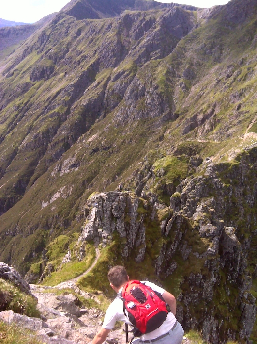
Having seen the drop from Am Bodach last time I was confident I could manage it, and the next section to the first Munro on the ridge Meal Dearg. Down I went, Jim leading the way. Slab steps and good handholds were plentiful here and I found it a far more pleasant experience than last time, when it was wet and greasy. Within a few minutes we were on a winding path up a short, steep ridge up to the summit of Meal Dearg. Visibility was good and I could see the route ahead. It looked, from here at least, manageable. Drop out now, or commit I thought. After the obligatory summit photo I committed...

Looking towards Meall Dearg

From Meall Dearg, looking along the ridge
I saw no point in looking to the end of the route, so I concentrated on simply the next few metres at a time. Within (I think) a few minutes we arrived at “the chimney” and I said to Jim that this was as far as I was going. I thought that had I to return that I would be unable to climb back down. Jims opinion was, that having seen me scramble before, that I would manage. He went up and I took a good look at the chimney again. What the hell, I had my brown pants on! I started up, the hand and footholds were obvious and within half a minute I was up. The Rubicon had been crossed.

At the summit of Meall Dearg. Keeching myself...
The rest of the jaggy part of the ridge was straightforward. Short stretches were as exposed as some other hills I've been on, and I used that to put them into context. “I can do this” I told myself. Other stretches were more challenging than I'd normally attempt, and had they been on another hill I'd perhaps try and work round them, but here that wasn't an option. Much of this part of the ridge is a blur, my concentration focused on the here and now, not logging the route or taking in the wider views. One part sticks out though. We came to a small drop, no more than five feet, but with a sheer drop to the one climbable side. Jim, having did the route three times already, attempted to go down. Despite his best efforts he couldn't find a way down. The sweat ran from his head, dropping on the dry rock. “I'll have a wee drink of juice and a think about it” he said, lowering his rucksack. I went over and looked at and thought I could manage. I lowered myself down, finding a foothold which left me just short of safety. My larger rucksack was now a bit of a hindrance, and there was no turning back from this move. What the hell- I was wearing brown underpants! A small leap and I had landed, safe and sound. All this took place in seconds, Jim had by now barely removed his rucksack, and looking round saw me already down. From this angle I was able to guide him down, but it was still difficult. Compared to the chimney it was barely a fifth of the height, but was far, far harder, as a slip at this point could see you fall several hundred feet.

Another group in front of us, thank goodness it was a weekday.
At one point a couple came behind us, and as they came down the steep slope one of them dislodged a large boulder which rolled down noisily, splitting as it went. The sound of falling, splintering rock eventually faded to silence. Had that connected with someone they too would have no doubt followed it down, and it was a sharp reminder of the need to keep the concentration level high, not to bunch up where the rock was loose, and to be aware of where other groups were. Bearing that in mind we let them carry on ahead of us...
The end is nigh!
We were fast approaching the end of the pinnacles and we could see the path rising up to the top of Stob Coire Leith, so we knew it wasn't far to go. To finish off though were some final sheer and exposed scrambles, and then I was down on what in relation to what had gone before was a vast plain, where I could leap around with impunity! In reality I was just glad I had managed with no major upsets.

Job done!

Looking back along the ridge
The remainder, as Jim described it, was hands in pockets stuff, and I could relax and take in the views now, down into Glencoe, to Ben Nevis and the Mamores.

Walking towards the second Munro of the day
Jim had shot off along the ridge while I took photos of him against the backdrop of the sea and Mull. I caught up with him at the second Munro, Sgorr nam Fiannaidh, where we sat in the sun and gazed out over Glencoe village and Ballachulish to Ardgour.

Rock face...

On top of Sgorr nam Fiannaidh

Looking out to Ballachulish

The Ballachulish Bridge
The Cuillin was a smudge on the horizon in the haze, and we could have sat here all night, were it not for the fact it was approaching 5 O'clock, and we had to work the next day. From where we sat it was only a mile and a bit to the Clachaig, but every guide book warns of the dangers of a direct descent. Previously Jim had descended south to Loch Achtriochtan, but he said it was rocky and murderous on the knees. Instead we headed to the end of the ridge and turned north west, heading for the bealach between this hill and the Pap of Glencoe.

The path down twists and turns...

Looking towards Sgor na h-Ulaidh, which I did in November 2011
We could see no obvious path down initially, but as we got lower we noticed a scar of lighter colour running across the scree, which led down eventually to a boggy path across the bare hillside.

This innocuous hole in the fence is the way off Scotlands greatest scramble
This in turn twisted westwards down through high bracken, then woodland, finally ending at the road opposite a cottage, where after negotiating a wire fence I was left with a mile and a half walk to the Clachaig.

The long road to the pub...
My knees were burning from the steep descent, but I put the head down and had just passed the Red Squirrel campsite when Jim appeared with the car, having jogged ahead. His knees are obviously in better condition than mine.

Beer? Don't mind if I do...
I felt that for once I deserved my beer in the Clachaig. Having sat and listened to everyones tales of adventure before, when I had slunk off back down Am Bodach, it was nice to have my own day in the sun. It had been a long time coming, and despite all my fears had been well worth the wait. That's not to say that I'll be rushing back, brown really isn't my colour...
