free to be able to rate and comment on reports (as well as access 1:25000 mapping).
After months of being stuck at home in the rain I finally escaped to places beyond the Malvern Hills.
Unfortunately in both cases it was for a mere dash up a green and soggy lump on my way to or from Aberystwyth – but hey its better than nothing!
Completing the Welsh Hewitts is starting to look achievable and hence there is a need to do some tidying up by picking off a few stragglers. The first was on my way to collect number 2 son from Uni just before Christmas, the bleak and soggy Gorllwyn.
The starting point was the layby with the Tourist information boards at the end of the lake under Craig y Mynach. I had to squeeze my car in at the end, because the layby had been completely filled with a huge pile of felled timber! Onwards and upwards, I set off down to track, crossing the river to the picturesque traditional farm house of Llanerch Cawr. If at this point had I re-read a particular trip report I would have not have made a schoolboy error and saved myself some time and trouble. Looking at my map there was a gap in the track from the farm house to the mountain on other side of a wide and lively stream. I therefore followed a lower track to cross a bridge, but then had to wade another stream and fight through the undergrowth of an abandoned bridleway before meeting the pristine chippings of the original track just up from the higher bridge that I should have used…… Oh well.
The track leads steadily upwards at a sensible gradient before coming to an end at an old stone quarry, presumably one used during the building of the Elan Valley dams. Just below it is a fine little waterfall and there was a fair amount of water around to feed it. Just after the track runs out, and it’s time to take to the grass.. There is a short flat section which ordinarily looks like it would be a soggy bog, but fortunately today the ground was frozen enough for it to be passable without incident.
A short steep slope followed, and then it was into the undulating bleakness that is the Elan Valley Hewitts. There is not a tree or feature of note all the way to the top, and it was a relief when I eventually made it to the stone circle and trig point that marks the top. Luckily for me the top was clear of cloud, but not so Drygarn Fawr away in the distance. It occurred to me this would be a forbidding place in thick mist.
There was a glimpse of a decent view up the valley to the much less visited dam of the Claerwen reservoir.
As time was short (that’s my excuse) I then belted back downhill the way I came, another Hewitt ticked off. This time however, I took the proper route over the bridge and past another set of falls that are somewhat hidden from view.
In all it took about an hour and a bit, but give yourself a couple of hours at strolling pace.
For a much better guide to Gorllwyn and its not so near neighbour Drygarn Fawr, I would recommend Poppiesrara’s report:-
http://www.walkhighlands.co.uk/Forum/viewtopic.php?f=16&t=14As a postscript to this part of the report, I did go down to the dam at Clearwen and came across a lovely set of falls a mile or so downstream. There have obviously been a few people who have taken their art a bit too far when trying to get THAT photo, as there is a sign warning that the rocks are dangerous and there have been three deaths!
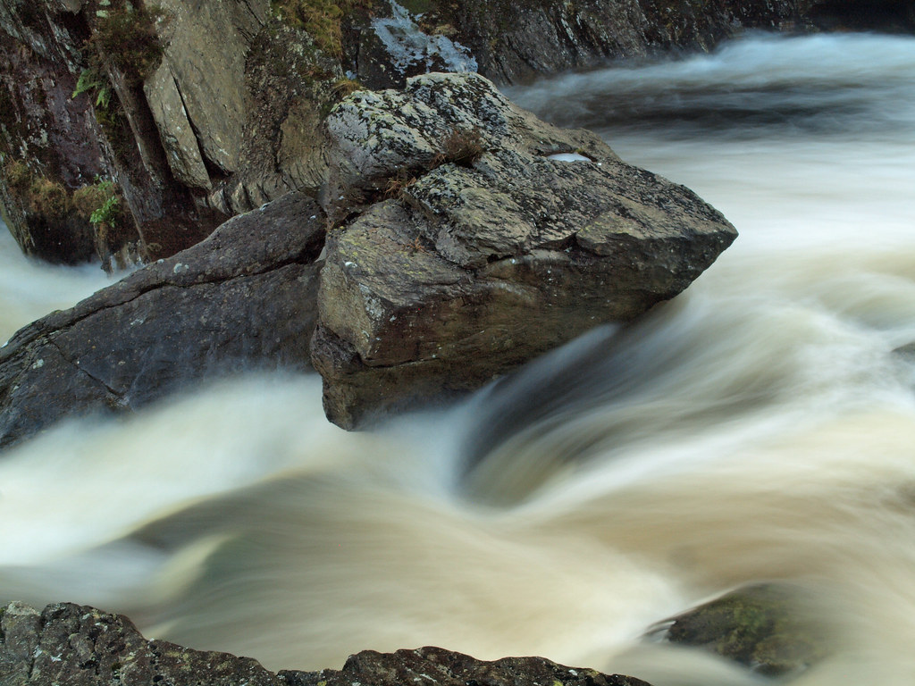 Pen y Bwlch falls, Elan. 2
 by
cliveg004, on Flickr
 Pen y Bwlch falls, Elan. 3
 by
cliveg004, on Flickr
Having dumped number 2 son back in Aberystwyth after Christmas, there was a brief opportunity to do some more tidying up. This time it was the last unclimbed hill in the Arans group, Pen y Brynfforchog. The rather dismissive description ‘A rather minor summit to the south west of Glascwm’ is on the one hand true, but it is also probably the reason I hadn’t climbed it before.
There is one saving grace to this short climb, it starts from the Bwlch Oerddrws parking area by the A470 which is more than 350m above sea level. The hill makes you pay for this height gain, the first 150 metres is a real lung buster following the fence up a steep grass slope. However, after that short sharp ascent, the rest of the walk is plain sailing.
On reaching the bump at the top of the slope, the rest of the hill comes into view – or would on a clear day…. As is quite common in these parts a fence traces the line of the watershed making navigation very simple, follow the fence to the top. The first stretch is on almost level ground, and so provides the chance to get your breath back. Level ground on a Mid-Wales hill normally means the use of a boat is advisory, but this hill is surprisingly well drained. Even on the flattest section it was just wet moss rather than the usual standing water, despite all the recent rain.
There is a faint path that bypasses another minor top, shortcutting a left turn in the fence. It is then a straightforward walk up the slope towards the summit and into the mist. Pen y Brynfforchog has a minor summit ‘ridge’, an out-crop of rock with a thin covering of grass. The fence runs below it as it was clearly too much trouble to get dig the fence posts in. The summit is marked by a small collection of bits of slate, calling it a cairn would be rather overstating it. I did check both map and GPS but no, this really was it. There was nothing to see in the murk, so about face and back down the mountain. I finally got a view again near the top of the steep slope, across the Bwlch towards the Maesglase group, also topped by thick cloud. Going up the slope got the lungs going, going down it was a real test for the knees.
This hill was knocked off in just over an hour, but as above, at strolling pace it could easily be done in under 2 hours by this route. I’d recommend Malky_C’s trip report on this area, excellent photos and a far greater test of endurance than this little bimble!
http://www.walkhighlands.co.uk/Forum/viewtopic.php?f=16&t=22290