free to be able to rate and comment on reports (as well as access 1:25000 mapping).
We are getting desperate to find new hills to bag in the east. Having climbed all Munros east of A9, we are now reduced to Corbetts and Grahams and even there, our choice is limited. A few C's with 10+km walk-ins can only be tackled on long summer days. That leaves us with a handful of mostly half-day climbs which in themselves, are not really worth the long drive to the other side of the Cairngorms. Because weather forecast for the west was wet-wet-wet, we had an idea of a "bagging spree". We would go to Braemar area and try to fit as many "quickies" as possible into a single day. In May or June, one could possibly do four, in March when days are shorter, three is probably the limit.
So Wednesday the 15th saw us getting up at a painful 5 am

The plan was to tackle Carn na Drochaide, a Corbett in Linn of Quoich, and a couple of nearby Grahams. Statistics at the top of my TR are for joint time, ascent and distance for all 3 walks, separate stats with particular maps.
1. Geallaig Hill
Distance: 6.1km
Ascent: 386m
Time: 1h 45min
The first hill of the day, Geallaig, would be best done in full winter conditions as some kind of traverse, using existing tracks and roads, but as we were on a bagging spree, we only did a "nip up to the summit" by the shortest route.
We parked in a large off-road area next to the cottage in Braenaloin:
Just opposite the farm, a metal gate gives access to an obvious track up the hill.
View west from the track:
It was a lovely morning but very cold and windy. Forecast was for cloud and rain to arrive in the afternoon and we were afraid this would be the only hill we'd get views from...
The nearby Morven snow-free:
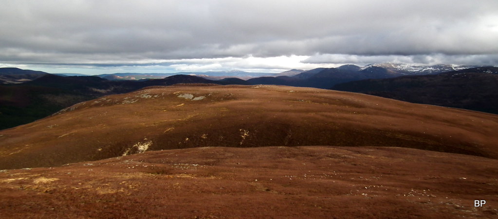
Zoom to the Cairngorms - Geallaig is a good viewpoint and this is probably the only highlight of this Graham. It's an easy climb of less than 400m up a wide ATV track.
In just an hour, we reached the summit shelter. One of the easiest Grahams in my career

Behind me - Lochnagar and friends.
One can continue along the track, over Creag na Creiche (lower top) and descend north to A939 - this would make some sort of circular. Another option would be to follow another track SW past some grouse butts, over a couple of unnamed tops, down to B976 about a mile south from the starting point. But as we didn't have time for a circular, we simply returned the way we came. Not a hugely inspiring hill, but a good vantage point for the Cairngorms and Whitemounth peaks, especially in winter.
......................
2. Creag Bhalg
Distance: 5.5km
Ascent: 305m
Time: 1h 40min
This is another "quickie" which can easily be added to a longer walk exploring Glen Lui. SMC Guide suggests starting from Linn of Dee car park, just to make this into a half-day climb, but as we were on a bagging spree, we opted for the shortest approach.
The starting point, a path in the forest (079900). There is enough space for 1 car on the grassy verge:
After about 200m of pleasant walking through the forest, the path joined a wider track. It was getting even windier now and we were glad to be protected by the trees!
View down to Inverey, weather beginning to turn nasty...
At the next junction (089904) we turned left and continued on a well worn estate track, with views opening up as we emerged from the forest. On a sunny day, Creag Bhalg is another excellent viewpoint, as it sits bang in the middle, surrounded by much higher hills. We didn't expect miracles, cloud was charging in from the west and we charged as well, to get to the summit before the clag.
The track, Morrone in the background:
According to available guides, we should expect a locked gate in the fence and a stile at 084908, but the gate no longer exists, it's all wide open. A few meters further on, we spied a path in the heather, branching off towards the summit of the Graham (it starts near a single dead tree). The rest was formality:
We walked past a single solar panel mounted on a metal rod (?). Looking back west, we saw the dark, cloudy sky and we knew that we had little chance to get views from our final hill, Carn na Drochaide. Just as well 2 out of 3 ain't bad

The Cairngorms not very friendly...
Creag Bhalg has a few different cairns, this stone shelter is about 200m from the top:
The summit area from the shelter:
View west down to Linn of Dee:
We walked to the summit and spent 10 minutes being pushed about by the wind. There are 2 cairns on a flat top, we took photos by the bigger one but to be honest I didn't really care which pile of stones was regarded as the true top, I just wanted to run down, back where the trees offered some shelter from the cold gusts!
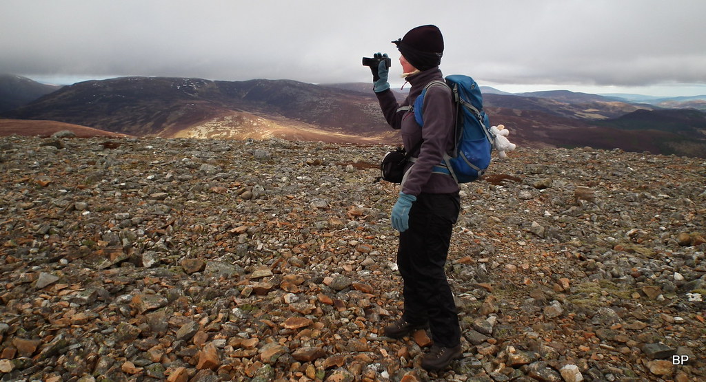
Lucy on her 31st Graham:
View south was a bit better but even here, the clag was descending on the mountain tops - what a change from the morning sunshine!
Again, we returned the way we came. On a better day and time allowed, it would be a nice idea to traverse to the eastern top (657m) and descend to the road using the SE shoulder. I will leave more creative options open for maybe another visit to Braemar area.
Back in the forest, we enjoyed a nice stroll down the track, with views to Inverey undisturbed:
Having returned to the car in less than 2 hours, we reviewed our progress so far. The original plan was to finish the two easy Grahams by 1pm, that would leave us about 5 hours of daylight, more than enough to climb the Corbett even if conditions deteriorated. We were about 30 min ahead of schedule, so we drove the short distance to Linn of Quoich car park, where we had a cuppa and sandwiches before embarking on our final journey
...........................
3. Carn na Drochaide
Distance: 14km
Ascent: 590m
Time: 4h
All right, this one started with a serous problem: how to get to the other side of Quoich Water?
Since the floods in 2015, the river changed its course and it now flows over the old road, making the bridge useless. We scratched our heads as it looked like we might finish our walk before it really started, but then I noticed a sheet of paper pinned to one of the wooden posts near the bridge - it said that the only way across the river is now over the Punch Bowl Bridge. It can be easily reached by following the path from the car park to the first junction and then turning right onto an estate track, which leads back to the river.
This smaller bridge is at 115913 and it looks brand new - obviously it must have been damaged by the floods as well but has been rebuilt recently:
The Punch Bowl hole, a popular tourist spot, but we had no time to play games here, our third mountain was waiting!
We returned to the main track on the other side of Quoich Water and only now we could see what really happened here in 2015...
A bridge to nowhere!
For the rest of the route, we followed the instructions from WH. Again, with more time and less wind, we would opt for a circular route, but with given conditions, a quick up and down seemed like the best choice.
The track form Allanquoich was a bit wet:
Dark cloud gathering in the sky... but at least it wasn't raining!
We walked past the farm at Allanmore. At 141920 a faint, grassy track branches uphill from the main road, I was the first one to locate it:
Braemar Castle from the distance:
We followed the obvious track for half a kilometer to a small group of trees where it splits - the right hand side branch is the one to take
Views were opening up nicely, if a bit dark and moody, but still much better than expected!
Morrone across the glen:
Looking south-west along River Dee:
The track peters out near the top of Creag a'Chleirich, which is said to be a nice short detour, but we decided to skip it as we wanted to be down before dark. Plus it was too windy to linger anyway...
The deep gap of Clais nan Cat:
The final climb is on heathery slopes and there are actually paths to follow, avoiding the most craggy areas:
Surprisingly, the clag was still above the summit of our target Corbett, so we stopped to take photos as long as we had any views to admire:
The upper slopes of Carn na Drochaide are home to countless mountain hares - well visible at the moment, poor sods, they haven't changed their winter outfit yet!
We picked one of the faint paths and stayed on it all the way up, avoiding crags. At the moment, we were in the lee of the hill so the wind wasn't so bad and we could enjoy the views, much better than we had hoped for!
Gazing in the distance:
View east towards Whitemouth mountains:
 2017-03-15 braemar three 166
As soon as we emerged on the rocky summit ridge, we were hit by the wind so strong that we struggled to stay upright! It almost took my hat of my head

But because we were so close to the top, we kept pushing against the gusts

It was a hard workout, but damn if I was going to turn back now!!!
Looking back down the rocky ridge:
The last remnants of good weather dying out on the eastern front:
Brace up, it's coooming!
 2017-03-15 braemar three 178
We reached the summit cairn with a sigh of relief, it was big enough to give us some shelter. I tried to use my camcorder, found it tricky to keep the balance
 2017-03-15 braemar three 190
 The Cairngorms now engulfed in cloud:
 2017-03-15 braemar three 185
 Kevin on the summit, just before we departed. Shame about the wind, this would be a superb top to have picnic on, all those views! If you are lucky

 2017-03-15 braemar three 206
 We gave up the idea of descending over the SW top Carn Dearg, as it would mean walking into that horrible wind all the way down. Instead, we simply retraced our steps down the sheltered side of the mountain, taking a shortcut just where the track turns away from the stream. We were back in the car with plenty of daylight to spare, but neither of us entertained the idea of climbing Morrone (the last Corbett in this area we haven't done so far) in that wind. Leave it for another day, Kevin said, as we departed from Linn of Quoich for the 2.5h drive back to Inverness.
"Another day" came only two days later, when we returned to Braemar to bag Morrone and a couple of other hills down the road. Weather has changed and we encountered snow on the summit, but this is a story for my next TR.
