free to be able to rate and comment on reports (as well as access 1:25000 mapping).
In July 2007, on a sunny summer day, we visited Dunvegan Castle and spent some time wandering around the grounds and the small garden adjoining the building. Looking west across Loch Dunvegan, I noticed two very distinctive, flat-topped hills.
"That's MacLeod's Tables" Kevin explained "I climbed them once in the eighties. Hell of a bog everywhere, but nice viewpoints."
Then he went on with his story, how his sister almost lost her boots, when she was stuck in the bog on the lower slopes of Healabhal Mhor. Kevin's tale didn't deter me from my desire to climb the Tables, quite the opposite. I was fascinated with the duo and put them on my list of places to explore in the future.
MacLeod's Tables from Dunvegan Castle, summer 2007:
 card 1 075
 by
Ewa Dalziel, on Flickr
Almost eleven years after my first visit to Dunvegan, the two hills were still on my to-do list and I was getting impatient. In 2007, they looked big and scary to me. By now, I have climbed things ten times more technical than a couple of Sub'2000 Marylins and no amount of bog could put me off!
Our week of traditional March hols brought us mostly dismal days with hours of staggering up and down windy slopes. Kind of madness. We enjoyed the whole experience with stony faces as any member of "the Bonkers Club" would do, but deep down in our hearts we missed the warm sun, the blue sky and unobstructed views in all directions. Luckily, the final weekend of our hols gave us some hope. Winds were still going to be strong, but sunny spells were forecast for the western coast.
"It seems the tables are turning for us." Kevin said "We could just as well go west and have dinner at Macleod's Tables."
I jumped up at this suggestion. We haven't been to Skye since last summer. It's a long drive from home, but we both agreed that after a week of Bonkers Club activities, we deserved a treat.
We followed the usual route for the two subs, starting from B884 about 1km north of Orbost, where there is space to park by a gate, below Cnoc a'Sga, the ancient dun. We climbed Healabhal Mhor first then traversed over a couple of minor bumps to Healabhal Bheag, returning to the starting point over An Cruachan and Beinn Bhuidhe:
The gate at the start, Cnoc a'Sga to the right:
As we started walking, I expected the ground to be very wet and boggy, but surprise, surprise, it was dry! Indeed, it was so dry that Kevin took off his gaiters and didn't bother putting them on again. The only wet-ish section was at the bottom of Glen Osdale, but even that only required a few jumps and hops

The ridge in front of us looked mouth-watering:
We descended slightly to cross River Osdale. On the other side of the stream we came across a barb-wired fence. It is not marked on 1-25k map and we couldn't see any gate/stile anywhere, so we had to resort to gymnastic movements to get over this unexpected obstacle.
Once on the slopes of Healabhal Mhor, it was relatively easy going, mostly dry and grassy:
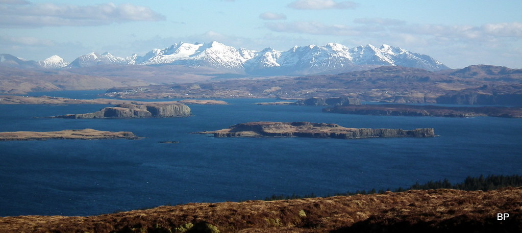
Dunvegan Castle can be seen across Loch Dunvegan:
Panoramic view north-east to Loch Dunvegan and the village:
About half way up, we landed at the bottom of vertical cliffs, but they can be avoided on steep grassy slopes either to the left or to the right, as one wishes:
 2018-03-17 macleods tables 032
 by
Ewa Dalziel, on Flickr
Vistas were already amazing, especially south-east towards the highest hills on Skye. The Black and the Red Cuillin ridge dominated the view:
Further to the north, the less steep side of Trotternish ridge:
The final climb is steep but very grassy. Nice, soft underfoot. Easy going. It was windy, all right, but not as bad as we had expected:
Countless stops occurred due to continuous desire for more photos

The summit plateau ("the table top") is very flat and the cairn, marking the highest point, is situated in the NW corner, the opposite end to where we emerged on flatter ground. I was eager to march across the summit meadow:
Kevin wandered along the edge of the plateau to take more photos. Both tables are good viewpoints, Healabhal Mhor is more "into the sea", better views of the coastline. Plus the Outer Hebrides on the horizon. It was sunny and no haze in the air, perfect conditions for one man and his camera
Yes, it was cold and a tad windy, but who would complain about such trifles.
My 25th Sub'2 Marylin. In contradiction to its name, Healabhal Mhor is the lower of the two Tables, I guess the name refers to the size of the table top
...and the whole top is ours! It's time to dine at the table!
Our meal at Macleod's Table was probably not as posh and plentiful as that of King James V (who, according to a local legend, was invited by Macleod Clan to enjoy a meal on the top of Healabhal Mhor), but sandwiches, tea and gingerbread never tasted so good before... We stretched our legs, propped against the cairn and gazed in the distance. Time passed. It was hard to leave this magical spot, but we still had another summit to climb, so eventually we packed up and began the descent towards An Sgurran. Healabhal Bheag dominated the view:
I couldn't take my eyes of the Cuillin:
We dropped to the first col and climbed the small lump of An Sgurran (297m). From here, we looked back at the northern Table. What an amazing shape:
It is possible to skirt the next small top, Beinn na h-Uamha, by contouring its slopes on the eastern side:
...but we decided, we had enough energy to traverse the lump in the middle.Kevin hoped it would be a good viewpoint to both Tables and he was right. We stopped on the top for another lengthy photo session.
The Duirnish peninsula from Beinn na h-Uamha:
Healabhal Mhor:
 2018-03-17 macleods tables 113
 by
Ewa Dalziel, on Flickr
Healabhal Bheag:
 2018-03-17 macleods tables 114
 by
Ewa Dalziel, on Flickr
The southern Table looks very steep from the next col, but it's less than 200m of ascent and there is enough grass to avoid the eroded sections:
Panoramic snap from half way up:
 2018-03-17 macleods tables 123
 by
Ewa Dalziel, on Flickr
As we ascended the second table, we were off wind and it felt like spring has arrived at last. Or maybe I was just overheating in my windproof jacket
Outer Hebrides (I think the highest tops are the hills of South Uist):
Healabhal Bheag has a trig point, but its true summit is about 150m to the south. We visited both spots, but took a longer break by the trig, where a stone shelter offered some protection from the cold wind.
Speechless:
The best view on the island:
Unlike its northern brother, Healabhal Bheag feels more "into the land", with better views to the southern side of Skye, from the Cuillin to Trotternish ridge. And of course, there must be wind turbines somewhere in sight

South to Isle of Rum. The small hill in the foreground is a Sub'2 as well, but we are not desperate enough to climb it just yet
Zooms to the Cuillin:
 2018-03-17 macleods tables 147
 by
Ewa Dalziel, on Flickr
 2018-03-17 macleods tables 148
 by
Ewa Dalziel, on Flickr
Happy Panther and wee Lucy by the trig point:
Posing with THAT pano behind!
Distant Torridon:
The edge of land and sea:
After a week of suffering, we got our reward. It's worth to be patient - good things come to those who wait. I couldn't escape from a moment of daftness:
Somebody was burning heather on the moorland and it spoiled the views just a little bit. The Red Cuillin pano:
Kevin on the summit of Healabhal Bheag:
We walked across the table top to the true summit:
It's an amazing landscape: land, sea, sky...
Rum zoom
:
 2018-03-17 macleods tables 188
 by
Ewa Dalziel, on Flickr
The steep southern slopes of the table:
 2018-03-17 macleods tables 204
 by
Ewa Dalziel, on Flickr
The Cuillin ridge once more:
 2018-03-17 macleods tables 216
 by
Ewa Dalziel, on Flickr
The suggested descent route goes due west, where a large, steep buttress should be avoided to the left hand side. I was the first to spot a well-worn path:
 2018-03-17 macleods tables 218
 by
Ewa Dalziel, on Flickr
As we descended into the shadows, temperature dropped very quickly and suddenly we were shivering from cold

The path is very eroded on the steeper section and care is needed here, especially when ground is frozen:
 2018-03-17 macleods tables 224
 by
Ewa Dalziel, on Flickr
Below the buttress, the path is less obvious, but route finding is easy and no more rocky obstacles in the way.
Emerging from the shadow:
 2018-03-17 macleods tables 228
 by
Ewa Dalziel, on Flickr
The buttress from below:
 2018-03-17 macleods tables 233
 by
Ewa Dalziel, on Flickr
The descent follows an obvious, wide ridge, over An Cruachan and Beinn Bhuidhe. On a wet day this would be a very boggy experience, but we were lucky and scampered over the dry heather wig big smiles on our faces. It was difficult not to smile with such an amazing landscape around.
The two Tables - panorama:
 2018-03-17 macleods tables 245
 by
Ewa Dalziel, on Flickr
THAT view again (Am I getting boring???):
 2018-03-17 macleods tables 247
 by
Ewa Dalziel, on Flickr
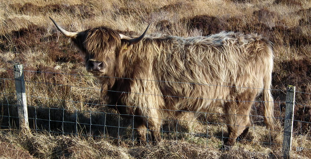
From Beinn Bhuidhe could see our car parked at the gate so we took a straight line of descent back to the road, walking past a pasture, where a small herd of happy Highland cows were busy chewing grass. They don't need a table to have their dinner, Kevin joked. One of the cows watched us curiously...
Mooo!
 2018-03-17 macleods tables 258
 by
Ewa Dalziel, on Flickr
The circuit can be done in 4-5 hours, but I don't see the point of rushing it, certainly not when weather smiles. Despite cold wind, we spent more time lurking around and taking photos than we did walking
The whole Table experience was worth the long drive from Beauly and I'm so glad we had a decent day for it!
.............
The final curtain call for the March hols came the following day, when we faced the crazy winds again on one of less known peaks of Torridon. TR to follow
