free to be able to rate and comment on reports (as well as access 1:25000 mapping).
I heard stories about this traverse. All kind of stories. But one doesn't really need to listen to hillwalking gossip, to know that the ridge of Sgurr na Ciche is a tough round. Maybe not a drasticly long distance to cover, but 1500m of ascent speak for themselves. Adding the fact that it's mostly on rough terrain in one of the remotest corners of Scotland might put many walkers off. As we are on our quest to finish the Munro list and in general, we love a challenge from time to time, no amount of bad publicity could stop us from laying siege to the rough bounds of Knoydart!

To make things a bit easier, we agreed we'd only tackle this route if weather is perfect. Which meant: 1. Dry, preferably after a prolonged spell of dry conditions 2. No cloud, so we could see the views properly (what's the point if you can't see anything???) 3. Low winds, so we don't get blown off the rocky ridge 4. Warm but no scorchio, so we don't need to carry gallons of water with us. 5. On a long enough day, so we don't end up walking back in the dark.
When looking at the above wish list, you'll probably say: what's the probability of having such a day in Scotland???
But we were in luck this summer. Monday, the 9 of July was exactly the right day. Warm, sunny but not overly hot, dry, low winds, etc. So the decision was taken: we're going up the Silent Ridge!
Why Silent Ridge? Let me explain. The word CICHE (pronounced cee-hee) means QUIET in Polish, so no wonder I nicknamed Sgurr na Ciche "The Quiet Mountain" and that evolved into "The Silent Ridge" in reference to the three Munros: Sgurr na Ciche, Sgurr nan Coireachan and Garbh Chioch Mhor.
We opted for the usual approach to the trio, from Glen Dessarry. The walk-in (and out) is on a decent track to Upper Glendessarry, then on a reasonable path. The paths in the upper glen are said to be soggy, but we encountered very little bog even higher up, that's what summer of 2018 did to Scotland!
Starting from the car park at the upper end of Loch Arkaig, we calculated we had roughly 13.5 hours of daylight which should be more than enough. The initial stage was walked quickly, on a good track to the Upper Glendessarry cottage:
You might have noticed the overcast cloud in the sky. Forecast was for the cloud to become patchy later on, but we were glad to have a cloudier day to start with. It meant we were not boiling hot from the very first miles and didn't use as much water. Also I didn't have to stop every 30 minutes to re-apply the sticky sunscreen to my UV allergic skin.
The path past the buildings in Upper Glendessarry was lumpy-bumpy in places, but overall good going. Dry as well which was a blessing. As every trip comes with some kind of problem, Kevin complained a bit about his boots, it was his turn to suffer from rubbing heels

It took him a few stops and sock/inner soles swaps to get the right combination.
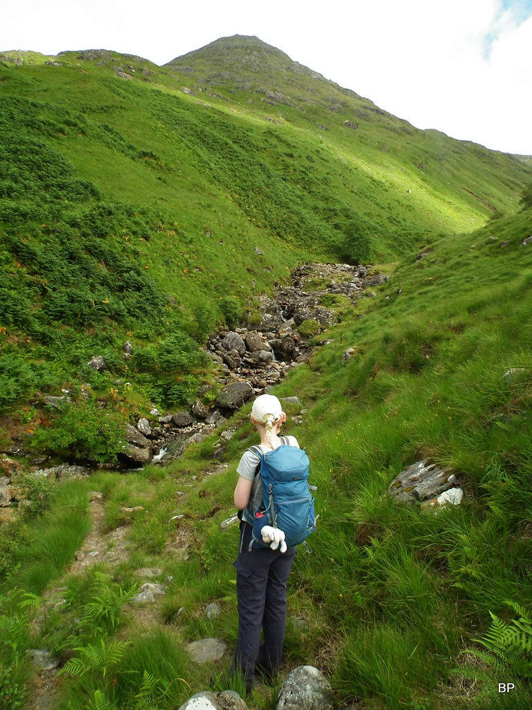
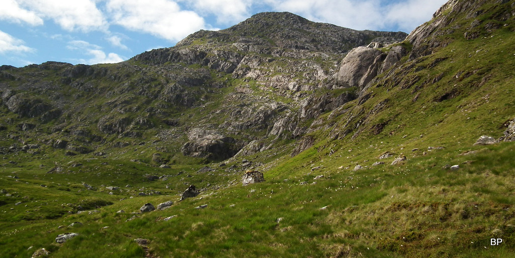
After a couple of hours of brisk walking, we reached the crossing of Allt Coire nan Uth which marks the beginning of the long, stiff climb to Sgurr nan Coireachan:
 2018-07-09 sgurr na ciche 015
 by
Ewa Dalziel, on Flickr
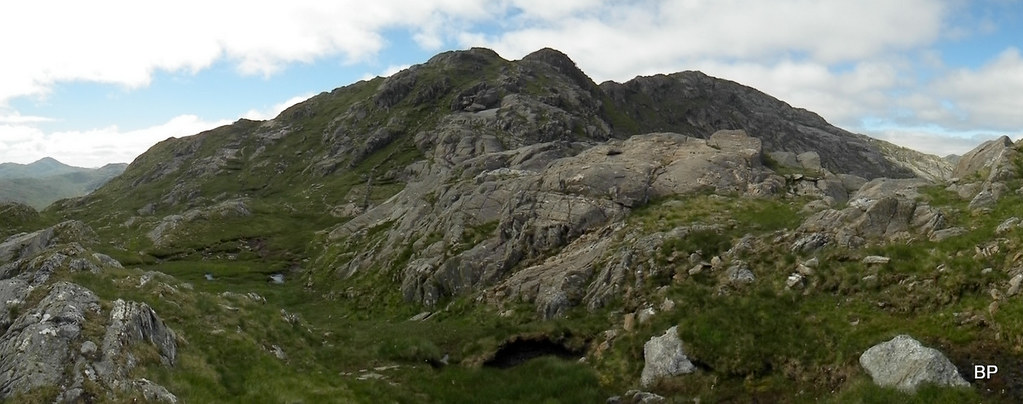
Having crossed the stream, we located a small cairn marking the start of a well-worn path up the first Munro. The angle is steep most of the way and there is no way to sugarcoat the fact that it's a relentless, laborious ascent of 700m. The path can be followed easily and it avoids all rocky sections, but it is a tiring experience.
The acute angle never changes:
...but the views back down to Glen Dessary are a sweet addition to the bitter pill:
Might look very difficult but honestly, the only issue is the steepness. If your muscles can stand the long march up the steep slope, you'll manage.
As we gained height, weather was improving (more sunny spells) and so did the views. Very quickly, we entered the world of sharp rocks, criss-crossed with patches of grass. The world of green-grey mosaic, crafted by the hand of nature. So rough yet so beautiful.
About 100m below the summit there is a short section where the angle of ascent eases off. We stopped here for some photos and a good slurp of water.
View south across Glen Dessary to Glenfinnian hills:
Loch Nevis, Rum and Eigg:
Vistas were already mind boggling and the best was yet to come. We were only at the very beginning of a wonderful journey, an experience full of breathtaking moments. How many times that day I stopped and simply gazed at the landscape with my mouth agape, simply struggling to believe that I was really there and saw all that rough beauty with my own eyes?
On the way to the summit of the first Munro:
 2018-07-09 sgurr na ciche 056
 by
Ewa Dalziel, on Flickr
From near the summit, looking down the way we came up:
On the summit of Sgurr nan Coireachan we met two gentlemen, who came up the same way earlier. They said they preferred to divide the walk in two and decided to retrace steps back to Glen Dessarry. Soon they left, leaving us to celebrate the wonderful views around.
On the top of Sgurr nan Coireachan, the easternmost of Silent Ridge Munros. My M no. 240, Lucy's no. 84:
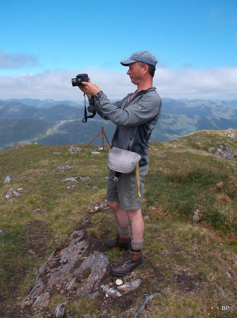
As you have probably guesses by now, Kevin spent most time on the summit wandering around with his camera, taking all sorts of photos. Weather was perfect and we knew we were so lucky to get good conditions up there, it would be a sin NOT to record what we saw.
Mr Cameraman:
 DSCF1082
 by
Ewa Dalziel, on Flickr
A few chosen snaps from the summit. I had to restrict myself to less than 10 otherwise this TR would have no end
Knoydart Corbetts and Sgurr na Ciche (left):
What was yet to come - The Silent Ridge in full glory.
Sgurr Mor and Sgurr an Fhuarain:
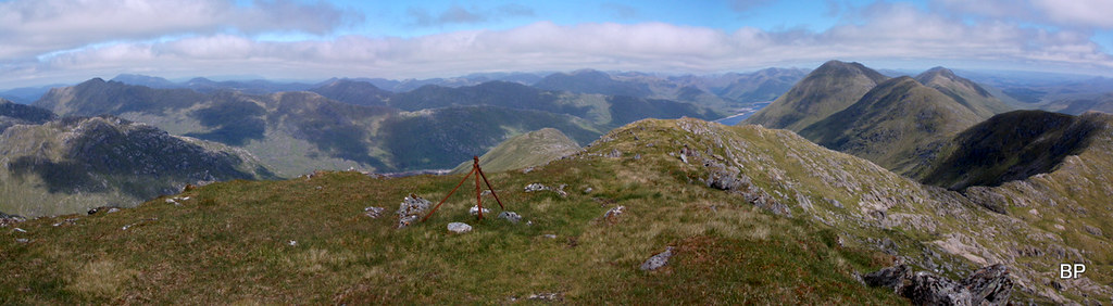
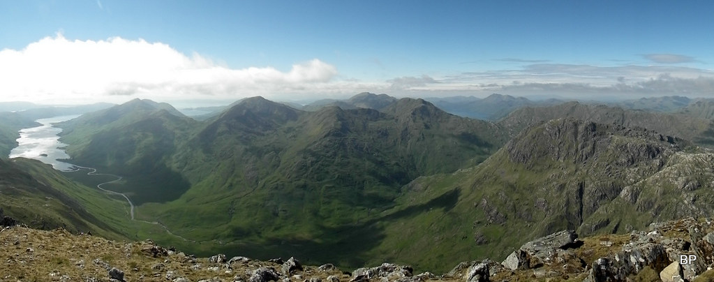
Panorama to the north and east:
 DSCF1075
 by
Ewa Dalziel, on Flickr
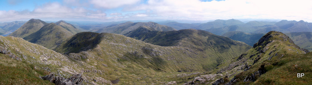
The south-eastern pano:
 DSCF1076
 by
Ewa Dalziel, on Flickr
The western pano:
 DSCF1074
 by
Ewa Dalziel, on Flickr
As we sat on the summit chewing sandwiches, we studied the 1-25k map and the WH description (sometimes it's handy to have a printout of that). Looking down to Bealach Coire nan Gall, we thought it was going to be even tougher going from now on, especially when traversing the long ridge to Garbh Chioch Mhor. The WH description of this particular section sounded very scary:
"The going is exceptionally rough with many steep ascents and descents and twists and turns to avoid rocky obstacles. It will probably take longer than expected to reach the cairn on this second Munro." 
As we studied the view in front of us, we saw two walkers near the top of Garbh Chioch Bheag, moving steadily up the ridge. Well, whoever they were, they could do it, so why shouldn't we?
Scary-looking next stage of walking:
I had a moment of doubt at some point, mentioning to Kevin that maybe we should divide the Silent Ridge in two, but he was adamant that I should stop moaning, believe in myself and move my a*** down the mountain!
Ahhh men and their lack of understanding for female emotions
Or maybe I needed a good telling-off, because he was right. I could do it easily. Later, when looking back at the Silent Ridge, I agreed there had been no need to worry. There is still life in the old cat!
We were walking into the wind now (it wasn't too strong but felt a bit chilly), so I pulled up my hoodie, grabbed my walking pole and gave the Silent Ridge one last look, before starting the descent into Bealach Coire nan Gall.
Sgurr na Ciche, here we come!
 2018-07-09 sgurr na ciche 080
 by
Ewa Dalziel, on Flickr
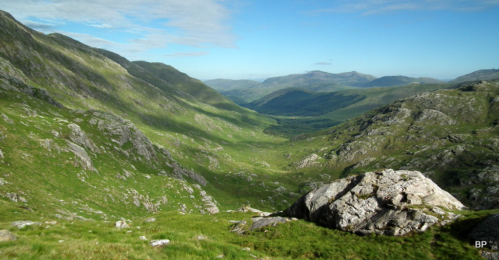
The descent is steep initially but an obvious, eroded path can be followed all the way down to the bealach. From here, it's about 230m of ascent to the lower top, Garbh Chioch Bheag, and another 50m to the summit of the second Munro. So much for the statistics. According to Walkhighlands walk description, we should expect a lot of additional up and down, so I braced myself for a very tough ascent and waited for the pain to come.
Sgurr nan Coireachan from Bealach Coire nan Gall - panorama:
The first stage of the ascent up the second Munro is steep but again, a reasonable path follows an old stone dyke. With good visibility, we had no navigating problems. It actually went much smoother than expected and soon we were nearing Garbh Chioch Bheag:
A little pano of what was yet to come:
 2018-07-09 sgurr na ciche 086
 by
Ewa Dalziel, on Flickr
As we traversed The Silent Ridge, I wondered where was all that additional ascend and descent? The only significant descent I registered was about 100m up the initial stage, where there is a short drop on the ridge. Later on, it's all steady uphill.
Looking back to Sgurr nan Coireachan and the lower reaches of the ridge:
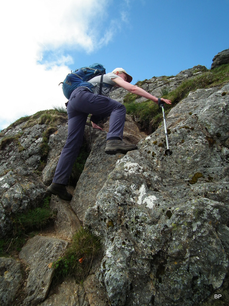
Near the lower top, the path becomes more sketchy and in places we had to scramble. Well, we didn't exactly HAVE TO (you could find alternative bypasses if you were very stubborn not to touch the rocks) but we wanted to and we enjoyed the easy scrambling sections:
 2018-07-09 sgurr na ciche 096
 by
Ewa Dalziel, on Flickr
Anybody for more fun and games?
From the top of Garbh Chioch Bheag, it's almost flat walking to the top of the Munro. Well, "almost flat" by my standards
Ben Nevis on the horizon:
Strange maneuvers on the path:
OK, it's not exactly flat, there are a few short, steep ascents with at least two places of easy scrambling (if you stick to the old stone dyke) but I was in my element and couldn't stop meowing!
 2018-07-09 sgurr na ciche 127
 by
Ewa Dalziel, on Flickr
Just before the final push to the second Munro of the day, we stopped to admire the northern cliffs of Garbh Chioch Mhor. So impressive...
Weather has improved even more, sunshine everywhere and the high cloud was reduced to patches here and there. But the cool breeze meant it didn't feel hot at all.
View back east to Loch Quoich:
With Lucy (M no. 85) on my 241st Munro. Behind us, the most interesting part of Silent Ridge, between Garbh Chioch Mhor and Garbh Chioch Bheag:
Panoramic version of the view:
 2018-07-09 sgurr na ciche 159
 by
Ewa Dalziel, on Flickr
As we sat down to have something to eat, I asked Kevin:
"What's the fuss all about??? Where was that horrific amount of ascent and descent en route???"
He just laughed.
"You're probably applying advanced settings to the game and expect the worst!"
He Who Always Knows Best posing with the summit cairn of Garbh Chioch Mhor:
Regardless of our feelings about the middle section of Silent Ridge, the day was not over yet. We still had another Munro to climb, and the most famous one of the three:
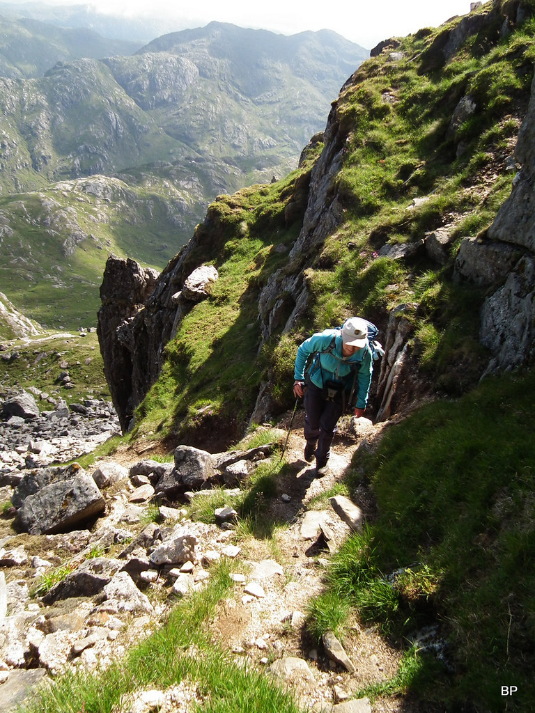
After a short resting break, we started the descent to the next bealach, Feadan na Ciche. Views were amazing in all directions and we kept stopping for photos. Initially, we still followed the stone wall:
Lower down, the slope becomes steeper and we encountered a few large steps where we had to stretch our legs down vertical rocks to reach the path below, but you can hardly call it scrambling:
About half way down, we stopped to study the final ascent to Sgurr na Ciche. We spied a path down the lower section. Later we discovered that this path, in one or another form, can be followed all the way to the summit. In the snap below, the line of the path is marked with red dots:
From Feadan na Ciche, it all looks plain sailing:
...but higher up, it's very steep and rocky. Care should be taken here, especially in bad weather, as it's very easy to step onto a loose stone:
Garbh Chioch Mhor from somewhere up Sgurr na Ciche:
 2018-07-09 sgurr na ciche 185
 by
Ewa Dalziel, on Flickr
Panther on the eroded path:
 2018-07-09 sgurr na ciche 191
 by
Ewa Dalziel, on Flickr
After roughly 200m of ascent, most of it steep and eroded, we emerged on the summit, to be welcomed by fantastic views. Sgurr na Ciche is like the icing on the cake for this route. The Silent Ridge, from Sgurr nan Coireachan to this point, is like a long and winding road, leading to the final peak, and on a sunny day there could be no better reward for the long day of climbing than arriving on Sgurr na Ciche to face the undisturbed view down to Loch Nevis:
On the summit of my 242nd Munro with our wee companion:
She is seriously addicted to hillwalking now! The Silent Ridge in the background:
Kevin just as gobsmacked as I was, posing with the cairn, and distant Loch Quoich:
Loch Quoich zoomed:
A few snaps from the summit - enjoy.
The wild wild west:
 2018-07-09 sgurr na ciche 210
 by
Ewa Dalziel, on Flickr
North and east:
 2018-07-09 sgurr na ciche 209
 by
Ewa Dalziel, on Flickr
Beinn Sgritheall and Loch Hourn:
Mighty Ladhar Bheinn:
The rough bounds:
 DSCF1092
 by
Ewa Dalziel, on Flickr
East:
 DSCF1094
 by
Ewa Dalziel, on Flickr
I find it hard to describe the feeling of elation and total bliss we had, sitting on the summit and sinking in the views. But there was still one issue before we could say: veni, vidi, vici (and in my case meow). We still had to walk back to the starting point
Luckily, the recent dry weather meant, even the steep descents were doable if with care:
 2018-07-09 sgurr na ciche 227
 by
Ewa Dalziel, on Flickr
We returned to Feadan na Ciche, carefully picking our way down the eroded slopes. From here, the route descends into a narrow, rocky gully. From above, it looks easy:
 2018-07-09 sgurr na ciche 232
 by
Ewa Dalziel, on Flickr
...but about half way down there is a steeper section and if we didn't know that this is the easiest route down the ridge, we might have second thoughts about following that gully!
Ehmmm, Kevin, are you sure this is the way down?...
 2018-07-09 sgurr na ciche 235
 by
Ewa Dalziel, on Flickr
It just looks bad from above. We encountered hardly any scrambling and there is a vague path all the way. The gully would be a different story in wet weather though, if the tiny stream dripping down the middle turns into a rushing river!
 2018-07-09 sgurr na ciche 237
 by
Ewa Dalziel, on Flickr
I must say that the gully makes for a good place to pose for scary photos, one to show later to your non-hillwalking friends, just to say "Look where I've been, look what I climbed". And then, you smile with pride when they look at you, gasping "WOW!".
 2018-07-09 sgurr na ciche 242
 by
Ewa Dalziel, on Flickr
Once out of the gully, the rest of the descent is said to be very squelchy, but we encountered hardly any bog. There is a well worn path to follow:
 2018-07-09 sgurr na ciche 248
 by
Ewa Dalziel, on Flickr
Saying good bye to Sgurr na Ciche. I'd love to return one day. What a mountain.
 2018-07-09 sgurr na ciche 250
 by
Ewa Dalziel, on Flickr
Glen Dessarry from above, our return route:
 2018-07-09 sgurr na ciche 255
 by
Ewa Dalziel, on Flickr
Lower down, we joined an eroded ATV track, which descends into the forest of Glen Dessarry. Above us, the mountains we just climbed, basked in the evening sunshine:
 2018-07-09 sgurr na ciche 260
 by
Ewa Dalziel, on Flickr
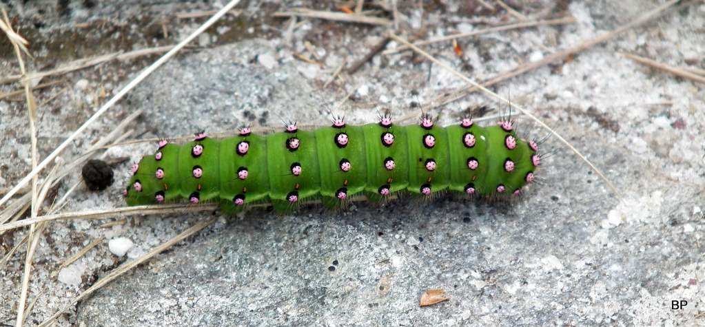
The glen was steaming with wildlife, like this emperor moth caterpillar:
 2018-07-09 sgurr na ciche 262
 by
Ewa Dalziel, on Flickr
There are two options on the return walk. One is to stay on the track through the forest, the other is to follow the upper path above the tree line. We chose the latter as we wanted to keep the views for longer. A few clegs came out for their evening meal, not as many as in previous weeks though, I think their hatching season is mostly over and thank God for small favours. They had been unbelievably annoying this year

It was half past nine when we returned to the car but we didn't push it on the way back as we knew that we had more than enough time before sunset. So 11 hours it took but I don't regret a single second spend in the wild, wild west of Scotland. Days like that happen once in a lifetime. This is one adventure I'll never forget.
.....................
After flying so high, in the following days it was more down-to-earth experience on Isle of Skye, when weather turned sour. We still managed to climb a few smaller hills and visited the cliffs, then had fantastic time during the WH Meet. So I have more TR's to write, mostly shorter ones. So in the next story, we'll be off to the Misty Isle

