free to be able to rate and comment on reports (as well as access 1:25000 mapping).
I've been busy with other duties for the last few days and had no time to write reports, so I'm now even further behind and in serious danger of forgetting the details of trips from over month ago

Apologies for the delay, but it all takes time, especially processing hundreds of photos from each walk

Today's report will be long and a bit sad. If you expect a quick instruction, how to climb the Ugly Step, I'm sorry, but this is not the right place to look for it. But if you enjoy long stories about iconic mountains, unexpected difficulties and lost planes...well, you're on the right page!
The Sail Mhor I'm going to describe today is not the Corbett behind An Teallach, but a subsidiary top of my favourite mountain, the mighty Beinn Eighe. I don't know why I have such a week spot for this particular hill, but there is something special in its shape and size, the steepness of the slopes, the whiteness of the quartzite rocks, the hidden secretive character of Coire Mhic Fhearchair, the way Beinn Eighe "embraces" the nearby Corbett Ruadh Stac Beag, the complex structure of the whole ridge, the breathtaking views, different from every point on the ridge... We had been up this one so many times before, different routes, different conditions, summer, winter, sun, mist... It's hard to believe that one might get BORED with this mountain, it simply keeps on giving. Like an old, loving grandma, it has one more sweet treat to offer every time I come back. Maybe that's why I'm so obsessed about it. Beinn Eighe is Panther's paradise!
But despite exploring my favourite hill from many sides, there was one top I never got around to climbing - Sail Mhor. usually, if we go up the stone chute and then continue to the southern summits, Sail Mhor is awkwardly placed to add it to the traverse. I wondered if it was possible to do some kind of "circuit of Coire Mhic Fhearchair", going up Sail Mhor (or to the col between Sail Mhor and Coinneach Mhor) and visiting the tops around the corrie, returning via the stone chute. I remembered someone in some report on WH mentioned easy scrambling between the two tops, but didn't really know much about the Ugly Step. Well, I was about to experience it on my own bruised skin
Our route:
The additional "treat" (I'm not sure it's the best word to describe it, but you have to forgive the foreigner) of doing this route was a visit to one of the best known plane crash sites in Scotland. We had walked past the remains of the Avro Lancaster many times, but so far, we didn't think about photographing the site and investigating the story behind the sad remains. Now it was time to rectify that omission....
There is a lot of information about this particular Lancaster TX264, how it crashed and the attempts of rescue (or should I say attempts of body recovering...), all you need to do it is to ask your good friend Google. It is not my intention to steal other people's research and writing, so at the end of this TR I'll add a list of links I used to put my story together. Some of the sites have photos of the parts of the wreckage we didn't reach, so they are worth a look if you want to see the whole picture of this awful accident.
But before we get to the plane, we begin with a leisurely stroll from Coire Mhic Nobuil, in the shadow of the NW tops of Beinn Eighe:
At this point, I was already concocting another possible route up Beinn Eighe, straight up Stuc Coire an Laoigh and then traversing to the Carls, but this is a subject for the future. So is a re-visit to Liathach, which looked very dark and moody today. It was a cloudy morning, but weather forecast was for sunny spells later in the day, so we stayed hopeful:
Despite gloomy weather, I was all smiles. later on, the visit to the crash site would put me in more sombre mood, but at the moment I was still my usual, crazy meowing self:
 2019-05-27 sail mhor B E 015
 by
Ewa Dalziel, on Flickr
A week earlier I had suffered from a minor back injury, probably a trapped nerve, and though I had mostly recovered, I could still feel a weak ache in my lower back, more annoying than harmful, but I kept it in mind, that I shouldn't attempt anything stupid today. Yeah ....I shouldn't. Who says that
The first sunny spell of the day over Beinn Dearg:
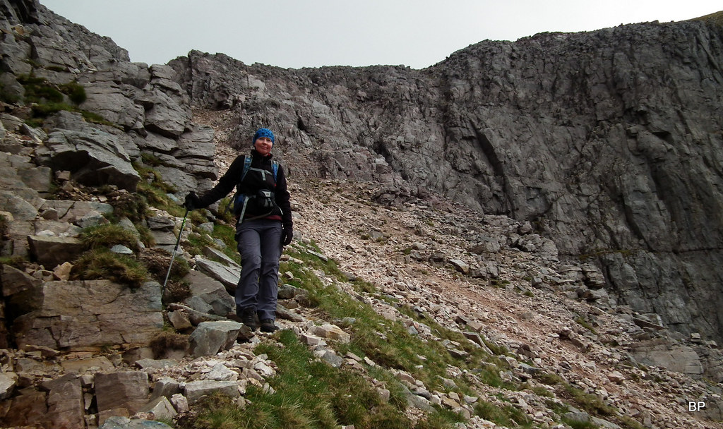
The walk to Coire Mhic Fhearchair is always pleasant, an when done on a reasonable day, you really can't find a better place to be!
Looking back at the mighty Liathach, panoramic view:
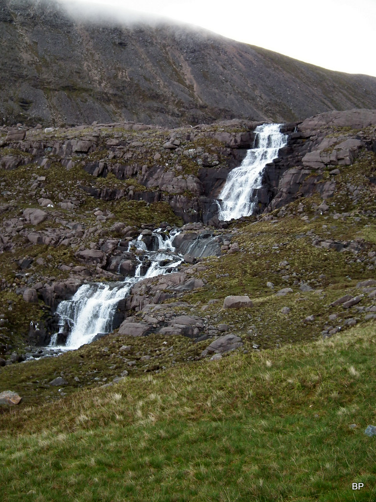
It had rained the night before and the stream running out of the loch was full, making the waterfalls very noisy:
 2019-05-27 sail mhor B E 057
 by
Ewa Dalziel, on Flickr
It didn't take us long to reach Coire Mhic Fhearchair, the corrie of Farquhar's son. Every time I reach this point, it's like a revelation, like entering a giant amphitheater of mountain madness

To the left is the highest top of Beinn Eighe ridge, Ruadh Stac Mhor, to the right, the nearly-vertical slopes of Sail Mhor. But the best feature must be the well known shape of the Triple Buttress:
Every time I look at the Triple Buttress, it reminds me of a similarly named peak in Polish Pieniny Mountains. The Polish version of the Triple Buttress is 983m high and despite the name (Trzy Korony translates as triple crown) it consists of five tops, lower slopes covered in forest:
The Scottish version is more "naked" with no or little vegetation on its slopes, but there is a striking resemblance in the shape of the face:
All right, I'm drifting away from the main subject, which is the specific climate of this particular corrie. And by climate I mean simply the magnetic beauty of this spot. As we walked along the loch tor each the crash site, the perspective changed:
The idea was to explore the area below the Triple Buttress and then climb to the ridge up the least steep line of attack, between Sail Mhor and Coinneach Mhor. From below, the invented ascent route looked possible:
Panoramic view of the Triple Buttress from below, with our planned ascent route to the right hand side. The first gully from the right hand side is the infamous Fuselage Gully, where some of the plane wreckage still remains:
Zoom to the upper part of the gully (photo taken later in the afternoon):
 2019-05-27 sail mhor B E 264
 by
Ewa Dalziel, on Flickr
We hopped over a small stream at the top end of the corrie and turned away from the main ascent route, an obvious path we climbed so many times, heading for the stone chute. This time, it was going to be a different tale to tell!
Almost immediately after crossing the stream, we spotted the first remains of the plane. We grabbed our cameras and started to wander around, trying to find as much as possible. Of course, we didn't move anything, just took pictures. As I surely must have mentioned in my previous stories about crash sites, why would anybody want to take home a rusty part of plane engine? If it's been on the mountain slope for 50 years or longer, it's where it now belongs.
One of the four engines:
Fragments of fuselage scattered around:
...............
A tyre from the landing gear:
A wheel hub from the undercarriage:
A large part of the wing, this fragment is well visible even from the distance:
The wing and view up to the Fuselage Gully:
Many small parts of the main body of the plane are wedged between the rocks:
 2019-05-27 sail mhor B E 118
 by
Ewa Dalziel, on Flickr
One of the most photographed fragments of the wreckage, a wheel:
Just above the wheel, hidden between large boulders, is the second Merlin engine:
 2019-05-27 sail mhor B E 131
 by
Ewa Dalziel, on Flickr
Close-up:
The entrance to Fuselage Gully above our heads looked like it's possible to squeeze in, but we knew that this was the route for rock climbers only:
Higher on the slope below the gully, we found more large chunks of the fuselage:
...including one of the propellers. A small memorial plague was mounted to one of the blades:
It was a somber moment for both of us. We stood there, thinking about the crew oft he Lancaster, tragically lost in the accident. What's even more touching, all eight men were very young, the youngest one was 19, the oldest - 29. Eight young lives lost to the mountain in just a heartbeat.
So what's happened?
It was the evening of the 13th March, year 1951.
The Avro Lancaster TX264 with eight crew on board took off from the airport at RAF Kinloss base. It was a routine training flight. After nearly 7 hours in the air, during which the crew practiced night-time navigation in the air somewhere between the Faroes and Rockall, it was time to head home. I can imagine that after long hours of duty they were all tired and looking forward to a hot supper and a warm bed... Instead of that, they found their final resting place in one of the most picturesque corries in Scotland...
Exactly what happened, will probably never be known. 6.5 hours into the flight, the crew reported that they were approximately 60 miles to the North of Cape Wrath. This was the last contact with the Lancaster.
At approximately 2 am in the morning, the 14th of March the plane collided with the mountain. Somehow, it flew into Coire Mhic Fhearchair and crashed right into the top of the Triple Buttress.
How did the plane end up in the corrie in the first place? According to available sources, weather that night was horrendous. Unsettled conditions and wandering weather fronts brought on strong north easterly winds. Add to it poor visibility and freezing conditions, the crew would have been struggling through it in pitch darkness and we can only guess how hard it must have been for them to keep the course. One mistake in navigation, and the plane flew too far south of the intended course.
 2019-05-27 sail mhor B E 127
 by
Ewa Dalziel, on Flickr
When the plane didn't return to the base, a search was ordered. On the 17th March a report was received that a red flash (explosion) had been seen in the Torridon on the night of 13/14March. The aerial search of Torridon mountains revealed parts of burned wreckage in Coire Mhic Fhearchair and on the northern side of Beinn Eighe at the top of the cliffs of the Triple Buttress. Sadly, the ground search party could not reach the site due to bad weather, deep snow and lack of equipment. It took time and effort to eventually reach the crash site. Four bodies were recovered in a relatively short time, the other four were harder to find and take down the mountain. The last body was only found in August, when most of the snow has melted to reveal it.
There is one positive post scriptum to this sad story though.
As a legacy to the struggle of the recovery team on Beinn Eighe, the RAF Mountain Rescue Teams as we know them today were formed.
This BBC article:
https://www.bbc.co.uk/news/uk-scotland-highlands-islands-12749720tells the story of one of the men from the original rescue team, who returned to the crash site 60 years after the tragedy. Well worth a look.
A very detailed description of the whole recovery mission can be read here:
https://heavywhalley.wordpress.com/2016/03/15/the-beinn-eighe-lancaster-crash-14th-march-1951-65-years-on/List of other sites with information about the Avro Lancaster crash:
https://www.peakdistrictaircrashes.co.uk/crash_sites/scotland/avro-lancaster-tx264-beinn-eighe/http://www.edwardboyle.com/wreck1.htmlhttp://www.yorkshire-aircraft.co.uk/aircraft/scotland/tx264.htmlhttp://www.wtdwhd.co.uk/Only%20rock%20climbers%20and%20nutters.htmlI assume that the spring 1951 must have been cold and in March/early April Coire Mhic Fhearchair was still in full winter conditions. Heavy snow slowed the climb and made the route up Coinneach Mhor nearly impossible. How did these brave young rescuers manage it, is hard to comprehend. According to the sources I read, they had very little if no rock climbing experience (especially winter mountaineering) and they were advised by a world class climber that "all non-mountaineers should stay away from the Ugly Step in wild weather"

Thinking logically, I wondered why they didn't try going up the stone chute and then traversing over Coinneach Mhor (today's tourist route to the ridge from the corrie), but maybe the chute was blocked by overhangs and considered a no-no that winter. Hard to say.
Having spent probably half an hour spying different parts of the wreckage all over the bottom of the corrie, we decided to follow the footsteps of the brave members of the 1951 MR rescue group. Of course, for us it was a dry summer day, some patchy cloud drifting around the mountain tops, low winds and overall, nearly-perfect conditions for clambering over boulders.
But first, we had to get onto the ridge. This part was easy, we had to follow the faint path climbing the grassy line between the crags to the ridge (can you spot two walkers half way up?):
The imposing bulk of the Triple Buttress from below:
The walk up the slope proved easy if steep, the path can be followed more or less all the way to the ridge:
The buttress from another angle. Always so intimidating:
 2019-05-27 sail mhor B E 168
 by
Ewa Dalziel, on Flickr
Panoramic snap of Coire Mhic Fhearchair from near the top of the climb:
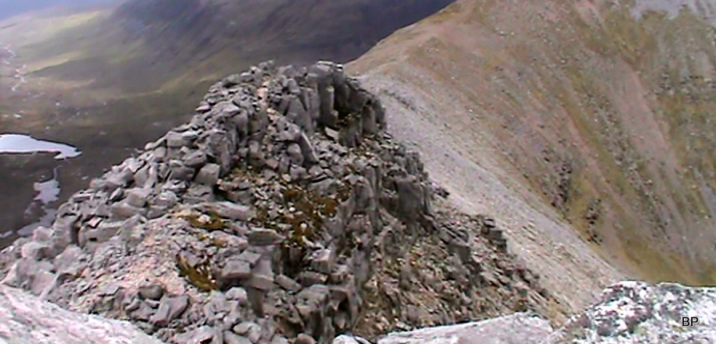
As we gained the ridge, we stopped for more photos. the summit of Sail Mhor was in cloud at the moment, but we hoped it might lift any minute. For now, we turned our attention to what awaited us later in the day, the infamous Ugly Step:
From this perspective, it doesn't look that bad, does it?
A couple of panoramas from the top of the ridge:
Liathach:
We reached the summit of Sail Mhor in 15 minutes (it's easy walking, a few boulders to hop over but no scrambling) and decided to take a longer break, waiting for the lingering cloud to disperse:
Lucy spent time admiring the vertical drops of Sail Mhor:
Baosbheinn, Beinn an Eun and Beinn a'Chearcaill emerging from the mist:
Zoom to the stone chute - looks nearly vertical from this side!
Beinn Dearg "on fire":
There was another group of walkers, getting ready to leave when we arrived on the summit. We watched them cross the ridge and tackle the Ugly Step. After the initial clamber over boulders, the disappeared from our sight for some time, later emerging about 1/3 way up the scrambling section. We saw them move up the step, and we decided if they could do it, why shouldn't we?
Because we expected hands-on-rock experience, we packed away our cameras, hence not much footage from the step itself.
A short paragraph from Irvine Butterfield's "The high mountains of Britain and Ireland" describes the Ugly Step as follows:
"This arm of the mountain runs east to A'Choinneach Mhor, which has a scrambly section to reach its summit, with an ugly step, Ceum Grannda, which overlooks an exposed drop to the corrie floor. (...) When approached from above, the line of the scrambling route is not very obvious, and the airy stances above the broken rock face do little to dispel a feeling of insecurity. There are good holds however and with care this awkward section is soon passed."Ok, so this is the ugly step when seen from Sail Mhor...
 2019-05-27 sail mhor B E 183
 by
Ewa Dalziel, on Flickr
...and this is how it appears on closer inspection:
 20190527135329(1)
 by
Ewa Dalziel, on Flickr
(apologies for the bad quality of the next few photos, they were still shots from camcorder)
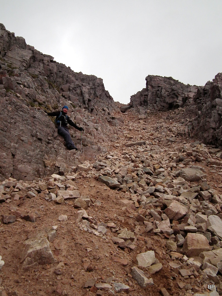
We headed for the Ugly Step, looking for at least a faint path guiding us to the easiest line of attack. And there was one, not that it helped much
We still had to clamber over big boulders, traverse above vertical drops, and climb up very steep and unstable ground. At one point, I glimpsed down between my feet and saw the stream in Coire Dubh Mor... Basically, the scramble is not technically difficult, it's more about careful route finding and ignoring the exposure, which on the bottom section of the Step is quite sensational!
Having reached the crest of the ridge about 1/3 way up, we could now see the vertical drop into Coire Mhic Fhearchair to our left, but the line of ascent was obvious. Kevin went first and guided me up, suggesting the best foot- and handholds. Soon I was completely lost to the world, concentrating only on following the safest route. I wedged my boots between rocks, grabbed boulders above my head, squeezed through one or two narrow gaps. Somehow, the adrenaline rush was pushing me up and I was enjoying this experience in a weird way!
Up the rocks:
 20190527135329(3)
 by
Ewa Dalziel, on Flickr
Looking down from half-way up:
 20190527135329(7)
 by
Ewa Dalziel, on Flickr
A little compilation of "Kevin in action"
 kevin scrambling
 by
Ewa Dalziel, on Flickr
Again, thinking about the rescue mission in 1951, I find it hard to believe how they managed the Ugly Step in wild weather, strong winds and half a meter of snow!
Eventually, the ground became easier and we emerged on the flatter summit area of Coinneach Mhor. Kevin wandered along the edge of the vertical cliffs, to catch a few more good snaps down to the corrie:
 2019-05-27 sail mhor B E 218
 by
Ewa Dalziel, on Flickr
Panther all happy and confident on the summit of Coinneach Mhor:
 2019-05-27 sail mhor B E 221
 by
Ewa Dalziel, on Flickr
The top of Fuselage Gully. Weather has improved now, with most of the cloud gone, so we could enjoy the sunshine while ridgewalking
 2019-05-27 sail mhor B E 219
 by
Ewa Dalziel, on Flickr
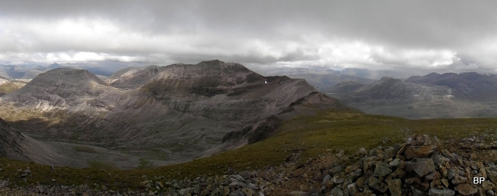
View from the top of Coinenach Mhor to the southern part of the ridge:
 2019-05-27 sail mhor B E 236
 by
Ewa Dalziel, on Flickr
We were under no pressure to continue to any other tops (we had been to Ruadh Stac Mor many times before) and as my back was now aching a bit, it was time to head down the stone chute.
Descending to the col above the chute, Ruadh Stac Mor in the background:
 2019-05-27 sail mhor B E 235
 by
Ewa Dalziel, on Flickr
I admit, I have never descended the chute before. I had always gone UP it and once even in winter conditions (didn't even need crampons that day as it was all soft snow). Now it was time for a new experience
 2019-05-27 sail mhor B E 241
 by
Ewa Dalziel, on Flickr
The middle of the chute is very eroded and a lot of unstable ground, so I decided that scramble-ish moves down the side wall were much safer
 2019-05-27 sail mhor B E 245
 by
Ewa Dalziel, on Flickr
Lower down, there is a wee path to the right-hand side as you face downhill, which makes the descent much easier:
 2019-05-27 sail mhor B E 247
 by
Ewa Dalziel, on Flickr
As we descended to the bottom of the chute, we met two locals wandering about:
 2019-05-27 sail mhor B E 253
 by
Ewa Dalziel, on Flickr
As seen from this perspective, the chute is nowhere near vertical and as long as you keep to the side of it and to more stable rock rather than walking in the middle, it's safe to go up or down:
 2019-05-27 sail mhor B E 254
 by
Ewa Dalziel, on Flickr
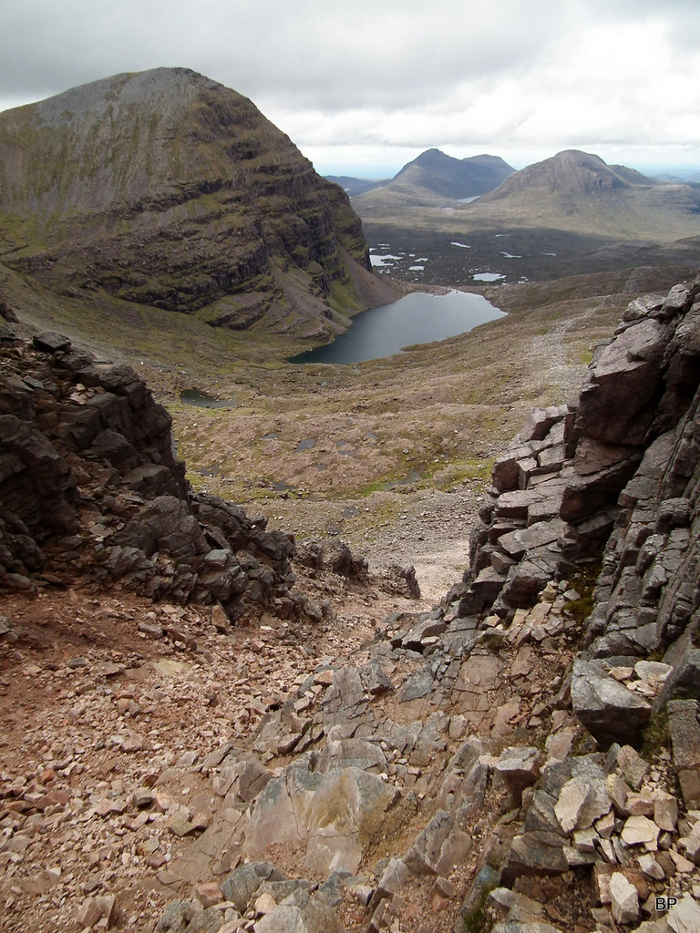
Sail Mhor and Loch Coire Mhic Fhearchair, one of my ever favourite views in Scotland
 2019-05-27 sail mhor B E 255
 by
Ewa Dalziel, on Flickr
We walked back around the loch, enjoying the sunny afternoon. We were in no hurry, this whole trip was more about exploring the mountain rather than beating any records. Some of you might be surprised that we didn't bother going to the highest summit, but we didn't really feel the need. The part of the ridge we did was entertaining enough
Sail Mhor and the Triple Buttress from across the loch:
 2019-05-27 sail mhor B E 268
 by
Ewa Dalziel, on Flickr
One last look at the famous corrie, before we took the path back to the car park:
 2019-05-27 sail mhor B E 270
 by
Ewa Dalziel, on Flickr
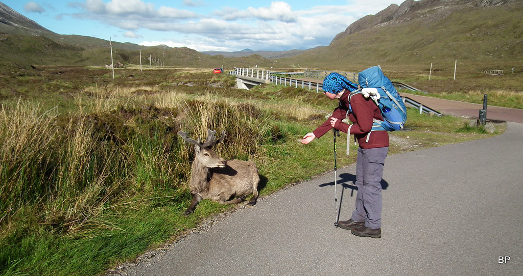
Back on the road, at the entrance to the car park, we met a young stag, sitting by the road. It looked healthy and didn't seem to be injured or suffering from anything. Quite the opposite, it behaved like it was waiting to be fed! Sadly, we had eaten all our supplies and even if we had something left, I'm not sure halva bars and jelly beans are suitable snacks for deer!
 2019-05-27 sail mhor B E 281
 by
Ewa Dalziel, on Flickr
We returned home fully satisfied, despite only walking a small part of the mountain, but in case of Beinn Eighe, any route is good and this particular experience will remain in my memories as something special. Not only because of the Lancaster story. It also tested my scrambling abilities and confidence, my self belief. I did it, without any hesitation and only with minor help from Kevin, who is better at route finding on steep slopes. The only side effect of my scrambling adventure was a set of lovely purple bruises on my knees, in places where I bumped against the rocks, not even realizing it
We will definitely return to Beinn Eighe and the next variation would most likely involve the Carls (Sgurr Ban and Sgurr nan Fhir Duibhe). My back ache is now gone, so thankfully it wasn't a serious injury and I'm ready to meow on more mountain summits!
....................
I have one more story to tell about plane crash sites. This one will be about Avro Anson which crashed on Na Tuadhan, the northern top of Conival in Assynt. But before I come to that, a shorter but very nice story about ridge-walking in the mist, while visiting a certain posh lady

TRs for both route in progress.
