free to be able to rate and comment on reports (as well as access 1:25000 mapping).
A rare interrupted weekend this one, thanks to Nick Cave at the Usher Hall. I don't give up my mountain days for many events, but I will make an exception for Nick. Therefore we'd have to do close to home things on Friday and Sunday. Fortunately Arran fall into that category for me at least (Allison having already been round all the Arran Corbetts at least twice). A dash down the road after she'd finished work on Thursday got us onto the 18:00 boat and a sunny evening's wander along to the campsite at Glen Rosa. There were only half a dozen other tents there. spread out over the fields by the river. The man in the wee hut seemed more interested in his skunk than taking any money for the camping - the reek was enough to get A stoned from just walking past him

We pitched and the midges found us. Shuttered inside the tent, reading. Quite a lot of rain showers overnight and in the morning - we stayed under cover til after 8:30 knowing it was supposed to dry up after 9am. I had a headache, which took some time to go away.
We were planning on climbing Caisteal Abhail, Cir Mor and maybe Goatfell. We could either get the boat back on Friday evening or leave it til Saturday morning. In addition I wanted to have a peek at the Simms I hadn't done - A'Chir (wondering if it was possible to get up from the east to the summit) and the two around the Witch's Step. Last time we'd done the circuit of 4 hills the tops had been in clag, so hopefully we'd get a better look today.
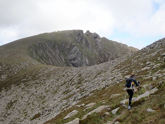
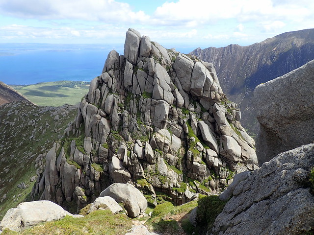
Along the track by the Rosa Water, the ground wet after the night's rain, but the vegetation verdant. A slow haul up into Coire Buidhe - looking at A'Chir from here there was a grassy slope running to the summit block that looked fine, but it wasn't possible to see what you'd do at the top. As it was 250m ascent to find out, we passed on that and continued along the track, pausing at the bealach between Caisteal Abhial and Cir Mor. Such an iconic mountain, Cir Mor, one of my favourite looking Corbetts anywhere.
 P6210393
 by
Al, on Flickr
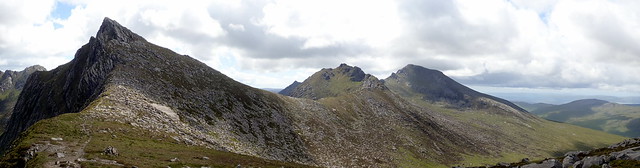
The Castles
 P6210396
 by
Al, on Flickr
Cir Mor
 P6210399
 by
Al, on Flickr
 P6210400
 by
Al, on Flickr
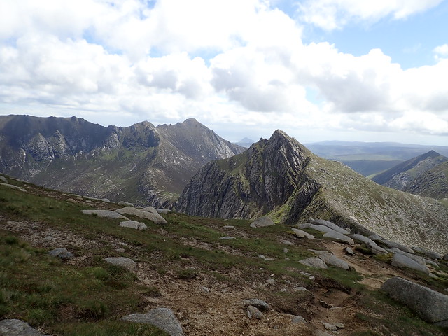
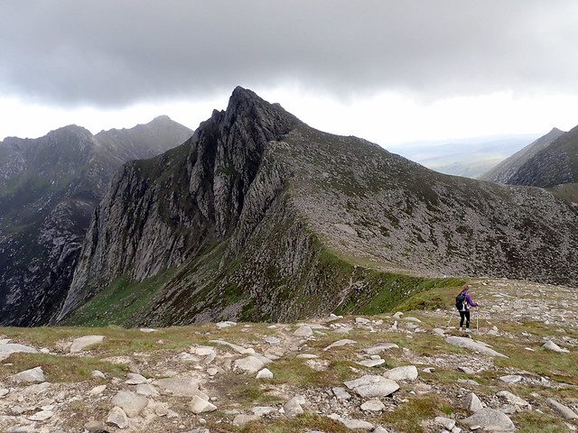
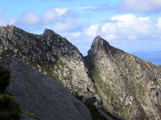
We left our packs before we reached Portcullis Buttress and continued to the fabulous castles unburdened. After summiting, we headed along the east ridge, following a clear path (although sometimes Allison decided to up the difficulty rating by going her own way). We reached the 758m summit, which is basically a huge boulder sitting on the ridge. It didn't look very easy to get up it - the west side offered the best holds, but that was also over a precipitous drop. We passed on that

Continuing on, we came to the junction with the deep "V" of the Witch's Step. That also looked interesting - an almost vertical pull up from the trough. Not today, either
But at least we've seen it at close quarters now.
 P6210402
 by
Al, on Flickr
 P6210404
 by
Al, on Flickr
 P6210405
 by
Al, on Flickr
 P6210407
 by
Al, on Flickr
 P6210408
 by
Al, on Flickr
Not the easiest boulder to summit
 P6210409
 by
Al, on Flickr
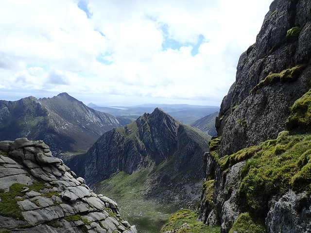
Witch's Step
 P6210410
 by
Al, on Flickr
We returned over Caisteal Abhail, retrieved our packs and continued on to Cir Mor. An easy walk up to the airy summit, then a much more challenging descent - once again A had taken an "alt" route off the hill which had a few tricky descent moments, especially with a big pack on my back. I lowered it down narrow sections a couple of times - the second of those it tumbled quite a lot further than I'd anticipated, sustaining some cosmetic damage, as they say. We picked up the more usual path and continued the long, long way back up to North Goatfell. We met a German girl looking for a place to camp on the mountain - but he asked it there was a "prettier mountain" than Goatfell to camp on. Don't know where she ended up
 P6210413
 by
Al, on Flickr
 P6210414
 by
Al, on Flickr
 P6210415
 by
Al, on Flickr
Yeah, it's quite steep
 P6210416
 by
Al, on Flickr
 P6210419
 by
Al, on Flickr
Reaching the top of Goatfell just after five pm we reminisced - this being the first hill we did together - and discussed what to do. We could get the boat back tonight, or we could camp somewhere on Goatfell. A was keen to camp out - it was a lovely evening and the Summer Solstice. The only problem was a lack of water...we'd better head down a bit then. Finding a large pool of clear water in a hollowed out rock fixed us up with what we needed. Finding a level spot was the next problem - we managed to get a pitch on the eastern shoulder, near the path. Sitting out in the sunshine whilst we ate our frugal meal, gazing out over the sea, watching the antics of a raven family until the midges became too persistent and we once again retreated inside. With no threat of rain, I kept the outer flap open, allowing us to continue to look out over the sea as the sun dipped ever so slowly. It seemed to barely get dark at all - even at midnight it was dusk rather than dark. A long slim orange glow spread along the horizon from the mainland streetlights.
 P6210421
 by
Al, on Flickr
 P6210423
 by
Al, on Flickr
Early morning Goatfell
 P6220425
 by
Al, on Flickr
A beautiful sunny morning - I wakened Allison up at 5:30. She was less than impressed, but I wanted to get the first boat. I reckoned it would take about an hour and twenty minutes to get from where we were to the pier - so no need to rush; the boat was leaving at 8:20. No midges this morning - a stiff breeze put paid to them. We breakfasted and got packed up by 6:30 and wandered down the path, enjoying the views. When we reached the Fisherman's path we could see the boat approaching the pier rather rapidly...should have enough time, put some speed on...Our plight wasn't helped by my taking a wrong turn and having to backtrack when faced with a rapidly running stream. We ended up having to run for it - until a man in a white van kindly offered us a lift for the last few hundred yards. We would have made it anyway, but it was a most welcome assistance. Ensconced on the boat, sitting outside to cool down after the heat from our run along the road, enjoying the cool sea air. A strange Saturday morning, to be heading home.
