free to be able to rate and comment on reports (as well as access 1:25000 mapping).
It was Saturday, the 8th of June, and Mr Weatherman warned us about possible thunderstorms over central Scotland, so again, our plans to go south-west to bag a new Munro (or two) had to be postponed. The stormy front was not supposed to reach the far north though... And we had a certain route in mind. This particular walk had been planned for years but somehow, we always had something else to climb first

Now, it was a perfect opportunity to pay the long awaited visit to the highest grave in Scotland.
A grave? Some of you might ask, did you mean a historic fort with burial sites? No, not at all. It's a modern burial site and the story attached to it is so tragic it brought me to tears when I first read the details. Just like in case of my Beinn Eighe report, I based this report on information available online. For those who would like to do more digging on the subject, there will be a list of links to all internet sources I used at the bottom of this TR.
I had come across the story of the lost Avro Anson a few years ago, when researching a popular plane crash database (sadly no longer available

) for accessible crash sites in the far north. I was surprised to find out that all the casualties of this accident were buried on site and the grave still exists today. More research and exchanging information with other WH members helped me locate the exact spot where the grave stands and draw a sensible route including a visit to the crash site and climbing the nearby top, Na Tuadhan.
At this point, many thanks to Sunset Tripper, who shared his photos and a route map to the site. Much appreciated

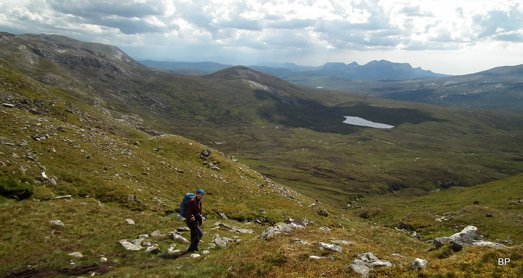
So our walk starts from Inchnadamph, but instead of taking the usual route up Conival, we followed first Allt Poll an Droighinn (good stalkers path!) then Allt Tarsuinn to Loch nan Cuaran. The war memorial is marked on 1-25k map as simply "grave". After spending some time filming the crash site, we continued up Imir Fada to the rocky summit of Na Tuadhan. The original plan was to simply go down from there using the standard route for the two Munros, but as we still had some time at hand and weather was holding, we nipped up to the summit of Conival for some spectacular views:
The morning was grey-ish but dry with sunny spells forecast for the afternoon, but it wasn't too hot, very pleasant conditions for walking. A few patches of morning cloud lingered here and there, but overall, we were in for a reasonable day:
We walked a short distance along the main track past Inchnadamph, but soon we turned onto a well-worn stalkers path (the start of this path is marked with a small cairn) leading into Poll an Droighinn.
The path is easy to follow and leads deep into the glen, with the steep slopes of Meall nan Caorach (a subsidiary top of Na Tuadhan) to our right.
Panoramic view towards the bulk of Meall nan Caorach from the path:
There are some nice waterfalls to admire en route:
 2019-06-08 conival 024
 by
Ewa Dalziel, on Flickr
Weather was improving as we walked. Kevin noticed, studying the map, that the path w were on continues to Bealach na h-Uidhe and it offers a superb alternative route to Glas Bheinn, a Corbet we had already done but would be more than happy to repeat:
Close to the spot where the path divides, we discovered a wee shelter:
The crossroad point is not very obvious, more a case of "follow the big, white stones"...
...but as we crossed the col and started to climb again, the path reappeared and we had no problems following it all the way to the loch:
Kevin studied the long ridge of Beinn Uidhe (to the right of this picture) and started making plans about traversing it at some point in the future

Glas Bheinn and the set of small lochs in the upper corrie below Bealach na h-Uidhe. Definitely a place to visit for some lurking around!
Higher up, the path becomes more rocky but there is no scrambling anywhere. The most difficult technical pitch is squeezing between these two rocks:
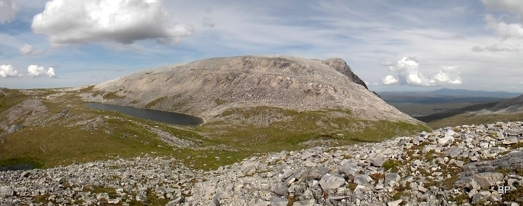
Loch nan Cuaran is a magical spot and would be a lovely place for a wild camp, but the close proximity of the graves makes it feel a bit spooooooky!
Nice view south-west towards the "Assynt weirdos" :
Suilven peeking out from behind Canisp:
We walked past the loch, aiming south-east, hopping on rocky ground. The path is very faint here and we didn't bother trying to follow it any more. In misty conditions, careful navigation is necessary at this stage:
It's just one big bouldery heaven
Lochan a'Caorach and Meall nan Caorach (left):
The path reappeared at some point, leading us up over more bouldery terrain, by a small stream. Kevin was moaning a bit, saying that he was hungry and in need of a break, but according to our map, we were close to the crash site and I said, it would be inappropriate to eat sitting next to an actual grave, so his sugar cravings had to wait!
Looking back in NE direction, towards Loch nan Cuaran and the long ridge of Beinn Uidhe:
We emerged on a flat, grassy shoulder, the path disappeared again and this time for good. It's a kind of wide "hanging valley" with a small river meandering through the middle, framed by the rocky higher slopes of Na Tuadhan:
The memorial is about 100m into the valley and can easily be spotted once you enter this flat, green amphitheater. Six men are buried here, all were serving RAF members. I'll tell more about them and their tragedy later, but first, let's take a stroll around the crash site.
The burial site has a new gravestone, which replaced an older one (a large cairn with a metal cross on top) in 2013.
Broken parts of the Avro Anson are scattered around, most of them half-buried in the labyrinth of peat hags. I must admit, my knowledge of plane parts is rather limited, but based on Kevin's suggestions and info found on other blogs, I tried to recognize what I was photographing. If I misidentified something, I'm happy to accept criticism

The area just south of the memorial, where most of the plane parts are, framed by the rocks, that location really adds to the feeling of isolation when you're there...
One of the engines - Armstrong Siddeley Cheetah:
Fragments of undercarriage with a wheel still attached:
The second wheel assembly, at the bottom of a boggy peat hag:
The location of the engine and one of the wheels in relation to the grave (left):
The second engine with one propeller blade still attached:
In the next peat hag, maybe 20 m further on, we found a lot of scattered debris, probably from the main fuselage:
One of the sources I read said that after the accident "the aircraft was broken up and pushed in nearby gullies", which if true, explains the fragmentation of these aluminum parts.
We spent some time in this sad place, and a sombre feeling we carried all the way through the rest of the walk. It's one thing reading about tragedies like this, but actually touching the gravestone and walking on the ground next to the place where the crew members of the plane are buried, is a whole different experience.
The story behind this accident is truly heartbreaking....
...
It was Sunday April 13th 1941, in the middle of 2nd World War. The crew of Anson N9857 XF-F from 19th Operational Training Unit based at RAF Kinloss were preparing for their training flight. It was going to be a cross-country training mission, the brave young lads being prepared for proper missions on the frontline. I imagine they must have been excited on one hand, but maybe also a bit scared, thinking about the future, about fighting the enemy up in the skies. Maybe they hoped that the war would be over before their training course ends?...
I'm trying to portray them getting the plane ready and climbing on board, six young, happy faces, working together as a unit, not aware that it was their last mission, that they would never return home
A few words about the crew. I feel obliged to list their names here, as we visited their resting place and paid our respect, I'd like to give these lost boys their names.
The Pilot was Flying Officer James Henry Steyn DFC, from Johannesburg, South Africa who despite young age (23 years) had completed 44 operations with another squadron before being sent to take part in the training scheme.
Pilot Officer William Edward Drew, from Barrow-in-Furness, Lancashire, aged 28, was the flight Navigator and the Instructor Observer.
Sergeant Charles McPherson Mitchell, from Ballater, Aberdeenshire, the oldest of them, but still only 31 years old, was the Observer under training.
Flight Sergeant Thomas Brendon Kenny, from Barnsley, Yorkshire, 20 years old, was the Wireless Operator and Air Gunner.
Sergeant Jack Emery, from Trowbridge, Wiltshire and Sergeant Harold Arthur Tompsett, from Croyden, Surrey, both aged 20, were trainee Wireless Operators and Air Gunners.
The crew was instructed to follow a route via Oban, Stornaway and Cape Wrath before returning to Kinloss. According to many sources, weather was far from ideal and the forecast wasn't optimistic either. The plane took of at 10:18. They reached Inverness without any problems, but when they passed Oban, they radioed a message to the base that they were forced to descend to 150m (500feet) to stay below the cloud level.
Later, it got worse. Above Kylerehea they encountered more bad weather and by the time they reached the airfield at Stornoway the visibility was really bad. The airfield had closed due to deep snow blocking the runways and the Avro Anson crew could not make an emergency landing there. If only it hadn't been snowing so heavily that day... If only.
13:02. a message was sent from the plane, confirming they decided to turn at Cape Wrath. Again, just my supposition, but I guess that they were trying to avoid the bad front, maybe climb over the cloud? There was nowhere to land and the only way to stay away from the storm was to actually be above it.
10 minutes later, the Wireless Operator at RAF Stornoway picks up a very faint Morse message coming from the Avro Anson. The last words ever heard from the crew of N9857 XF-F. A heartbreaking call for help, a proof that they were fighting till the last moment to keep the plane in the air:
"icing up...........lost power in port engine...........losing height........descending through 3,000 feet ......."
Again, I'm switching on my imagination I'm trying to see it through their eyes. The plane with only one working engine, the pilots struggling to see anything through the snowstorm and the thick cloud... They fall below 900, then 800m, suddenly a mountain ridge emerges from the storm. They know they are too low, they can't gain any height with just one engine. The mountain ridge grows closer. It must be a snap decision or they will crash. They spot what seems a small flatter area between Beinn a Fhuarain and Loch nan Cuaran. Far from a good landing spot but maybe, just maybe, there is a chance...
![2019-06-08 conival 141.JPG]()
As they attempt the emergency landing, the right wing catches a rocky outcrop (one of the knolls surrounding the flat meadow) and shatters to pieces. It sends the whole plane cartwheeling and as it turns over and over, losing small parts of the fuselage on the way, the fuel from the wing catches fire. The plane eventually grinds to a halt in the middle of the flat area, and the fire eventually burns out.
It is just my interpretation of what happened. We don't know how it really looked like. But one thing is a fact: at least 3 crew members survived that nightmare crash.
Those who are still alive, are most likely wounded. And don't forget, we are in the middle of a ferocious snowstorm, on a remote mountain, at the height of roughly 660m. But they are still breathing. Maybe there is still hope. Maybe the storm will stop eventually and someone will find them before it's too late...
The storm is so bad they stay inside the remains of the plane. It's so cold they can barely move, but they dig up parachutes and use them as duvets. At least it gives them some comfort, not much, but better than nothing.
Sergeant Charles Mitchell is the lucky one. I don't know what kind of injuries he had, but it seems he was the strongest and the only one capable of walking. He looks at his fellow crew members, shivering under parachute canvas, and deep down in his heart, he knows: they won't last long. The storm is showing no signs of abating and the wounded boys really need help. He has to go.
Did he say anything to his wounded friends when leaving the safety of the broken plane? Did he promise them, don't worry, lads, I'll be back soon with a hot cup of tea? Or did he simply get up and walked out into the white hell outside?...
It was one of the most severe blizzards ever recorded in the area of the North West Highlands. In over 100 years, the locals haven't seen anything like it. On the very same day the Avro Anson crew met their fate, three shepherds from
Inchnadamph tried to gather their sheep into shelter. They were also lost to the storm, only half a mile from the safety of their homes.
Sergeant Mitchell didn't know he was facing the storm of the century. He hoped there was a simple way off this ridge, maybe there was a village at the bottom of the glen?
So he walks on, struggling through the snow, fighting the wind gusts, trying to somehow find the way down the mountain. Instinctively, he follows the descending ground. He staggers as the blizzard blows sticky snow into his face. His hands are so cold he can't even feel them any more. But he walks. He fights on...
Sadly, Sergeant Mitchell does not realize that he is walking in the wrong direction. Following the dropping ground, he is heading east, away from Inchnadamph, away from any human habitation.
Another gust of wind pushes him against a large rock. He's so cold, so tired. Maybe if he could hide behind this boulder for a short time, just to rest a bit, perhaps wait out the worst of the blizzard?...
...
And that's where his body was eventually found, sheltering behind that boulder. I hope he just fell asleep there, tired and cold, maybe his last dream was about people he loved, his family. But we will never know.
...
Originally, the plane was presumed lost at sea and the air search was suspended after a few days. But on the 25th May 1941, nearly 6 weeks after the Avro Anson had crashed, a local shepherd, Mr Law, was out on Beinn an Fhurain, most likely tending to his sheep. He found the remains of the plane and alerted the authorities.
Five bodies were found inside the wreckage and soon the recovery team located Sergeant Mitchell, as it turned out, he managed to walk half a mile before succumbing to cold and tiredness.
The decision was taken to bury the six crewmen side by side at the scene. The grave was marked with a large cairn made of peat and rocks. Later, a metal cross was added. In 2013, a new gravestone replaced the old one:
Sleep well, boys. You are not forgotten.
...
It was a sombre moment for us both, when we stood there at the very spot where it happened, trying to imagine how this flat shoulder would look like in winter conditions, in blizzard

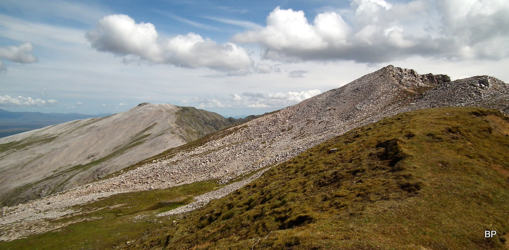
Eventually, we realized that we had spent far too much time here and we were now running late, so we had to move on. The idea was to traverse along the rim of the east-facing corrie to the summit of Na Tuadhan (also called Beinn an Fhuaran but Na Tuadhan is the name given on Hillbagging website so I'm sticking to it).
The initial walking is on grass, but soon we encountered more rocks:
Having reached the edge of the cliffs, we uttered a few aaahs and ooohs because this part of Conival, virtually unknown to Munro-baggers and seldom explored, is breathtaking:
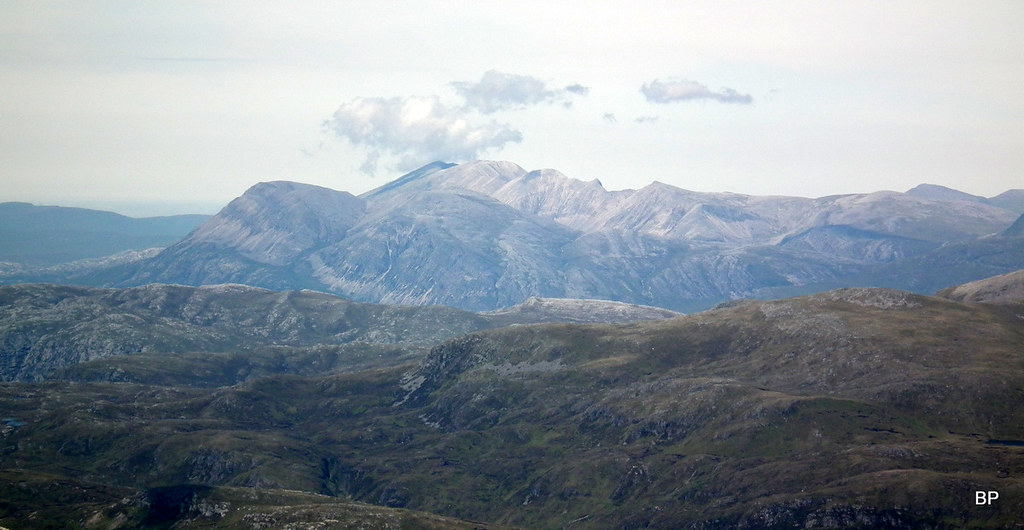
More distant views are superb as well. Beinn Leoid to the north, with Arkle & Foinaven group behind:
View back down to the crash site area, on the horizon to the left, Quinag:
Zoom to Arkle and Foinaven:
Heading for the final climb, some seriously fantastic ridgewalking en route!
About half way up, Kevin started to moan again that he was hungry and needed rest, so we stopped for lunch, with superb views down the bottom half of the ridge and the mountains of the Far North on the horizon:
Later, we continued our cliffwalking experience, and spent far too much time photographing every nook and cranny:
 2019-06-08 conival 190
 by
Ewa Dalziel, on Flickr
Just amazing:
 2019-06-08 conival 205
 by
Ewa Dalziel, on Flickr
As I said, this part of Conival is not a part of the usual approach and is rarely visited, but there is a faint path along the ridge. We walked past some interesting pinnacles:
View north again:
The 1-25k map shows the highest point of Na Tuadhan on the western side of the summit area, but according to Hillbagging databaste, the summit is at NC 30375 21471, on the north-eastern end, above the big drop to Coire a'Mhadaidh:
 2019-06-08 conival 226
 by
Ewa Dalziel, on Flickr
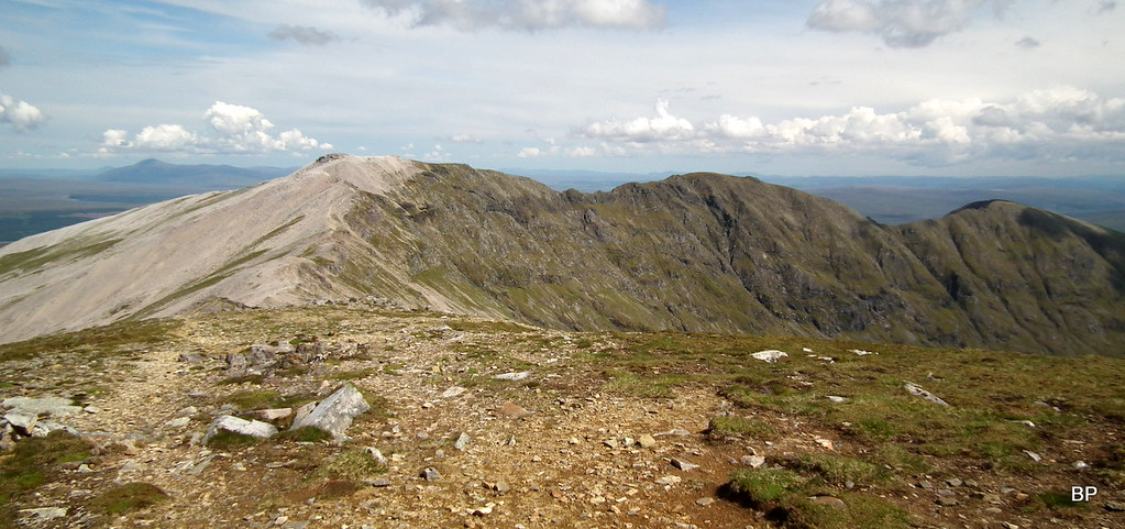
From the top of Na Tuadhan, there are lovely views to the main Conival-Ben More Assynt ridge:
 2019-06-08 conival 231
 by
Ewa Dalziel, on Flickr
...as well as the corrie below:
 2019-06-08 conival 222
 by
Ewa Dalziel, on Flickr
The descent to the next col, between Na Tuadhan and Conival, is quite rocky and very steep in places, care is needed here, mostly to avoid slipping on loose rock:
 2019-06-08 conival 234
 by
Ewa Dalziel, on Flickr
The descent seemed neverending and for the time being, we were lost in the world of white rocks...
 2019-06-08 conival 238
 by
Ewa Dalziel, on Flickr
We sat for a short break on the col. It was 2pm and weather has brightened significantly. We were aware of the storm warning for the later afternoon, but at the moment conditions looked fantastic so we decided we had enough time and steam left in our legs to add Conival to our route.
Looking back to Na Tuadhan from the path up Conival:
 2019-06-08 conival 244
 by
Ewa Dalziel, on Flickr
More white rocks on the final climb, but at least there is an obvious path:
 2019-06-08 conival 249
 by
Ewa Dalziel, on Flickr
Quinag and Loch Assynt:
 2019-06-08 conival 254
 by
Ewa Dalziel, on Flickr
Braebag:
 2019-06-08 conival 259
 by
Ewa Dalziel, on Flickr
View north to the route we took earlier:
 2019-06-08 conival 265
 by
Ewa Dalziel, on Flickr
The climb to Conival is easy and soon we were near the top. We had done both Munros (Kevin had been here twice before) so there was no pressure on us, we could make the walk as long as we wanted and not worry about missing any targets
Conival and Ben More Assynt:
 2019-06-08 conival 263
 by
Ewa Dalziel, on Flickr
The ridge of Ben More Assynt from Conival. Kevin suddenly started talking about climbing BMA via Eagle's Rock
 2019-06-08 conival 270
 by
Ewa Dalziel, on Flickr
Lucy on the summit, she was the only one celebrating a new Munro. Her 113th, to be precise:
 2019-06-08 conival 279
 by
Ewa Dalziel, on Flickr
Posing with Braebag on the summit of Conival:
 2019-06-08 conival 280
 by
Ewa Dalziel, on Flickr
Arkle and Foinaven - zoom:
 2019-06-08 conival 282
 by
Ewa Dalziel, on Flickr
Do we have to go home?... maybe one more mountain?
 2019-06-08 conival 284
 by
Ewa Dalziel, on Flickr
Theoretically, we had time to do BMA, but as Kevin really warmed up to the new route (via the southern ridge), we decided to head back to Inchnadamph. We had done more than planned anyway, and the visit to the crash site was a truly touching experience. Let's leave something to explore for another day.
On the way down, we met some curious locals:
 2019-06-08 conival 290
 by
Ewa Dalziel, on Flickr
Descending into Gleann Dubh, we basked in sunshine:
 2019-06-08 conival 294
 by
Ewa Dalziel, on Flickr
Weather held nicely and we didn't see a drop of rain today:
 2019-06-08 conival 307
 by
Ewa Dalziel, on Flickr
The path in Gleann Dubh is muddy in places, but overall, the whole route was a dry experience:
 2019-06-08 conival 317
 by
Ewa Dalziel, on Flickr
The classic view of Quinag and Loch Assynt on the way back to Inchnadamph:
 2019-06-08 conival 321
 by
Ewa Dalziel, on Flickr
The whole circuit took us 8 hours, but if you spend less time faffing about and photographing every rock or plane part, you could easily add Ben More Assynt to the route. It would add up to over 1300m of ascent, but it's well worth the extra effort
I hope that my story wasn't too long... I think I was lost into the story at some point, trying to imagine that tragic day on Na Tuadhan. I have visited many crash sites on my quest to climb Scottish mountains, but this was the most emotional experience so far in such a spot. If you decide to follow our footsteps, the memorial is relatively easy to reach, just follow the path along Allt Poll an Droighinn and past Loch nan Cuaran. And when visiting, please don't kick any plane parts around. It's a resting place. Treat it with respect.
...............................
My next report will take us away from mountains, if only for a short time. We'll take a stroll along the cliffs, watch the wildlife and later, pay a visit to a fascinating old castle. TR to follow.
..............................
Websites with information about the Avro Anson crash:
https://www.bbc.co.uk/news/uk-scotland-highlands-islands-18262312https://www.peakdistrictaircrashes.co.uk/crash_sites/scotland/avro-anson-n9857-ben-more-assynt/https://aviation-safety.net/wikibase/wiki.php?id=144775https://rafmountainrescue.com/crash-site-of-raf-avro-anson-gr1-near-ben-more-assynt-update-by-simon-lloyd-morrison/https://heavywhalley.wordpress.com/2017/05/04/heading-to-assynt-to-the-anson-crash-near-ben-more-assynt-to-check-out-the-memorial-on-the-mountain-with-the-war-graves-commision/