free to be able to rate and comment on reports (as well as access 1:25000 mapping).
Magic in the Mamores 
My year out in the hills started on the 4th January and was particularly memorable, but for all the wrong reasons. I don’t want to dwell too much on that night again, but a catalogue of mistakes cumulated in a forgettable outing, and subsequently my last solo overnight outing, until now!*
*If you are more interested in dramatic Walk Reports – here might be a better bet -
Lesson Learnt - A Night to Forget“Now” was the 11th May and to most people 5 months (spread across winter) would not seem like a long time but trust me when I say it felt like a very long time. Admittedly, I had been out 6 times since including two overnighters – both of which were with company.
For this weekend none of my other hill walking pals were free so I set off to Kinlochmore early morning from Stirling with the intention of doing my final 4 Mamores. I had done Stob Ban and Mullach nan Coriean as a nice day walk and had an epic overnighter on the Ring of Steall.
I suspect this could be a heck of a view higher up
I talked about it in more detail when I wrote my Walk Report from the Ring of Steall. To recap; fair play to those that do all the Mamores in a day, physically extremely impressive, a feat I do fancy doing one day, but for now… what’s the rush?! Today was all geared up for a slow and steady.
Looking back, these photos really don’t paint an accurate representation of the weather. In large parts of the country winter was very much still hanging onto the higher tops, however the Mamores and Nevis range seemed to be almost exempt. After the near disaster on Sgurr na Lapaich, I packed my 1-man tent but also took the bivi as I wasn’t 110% convinced the ground would be thawed at 900m+, which was one of the many problems from 5 months ago.
Not bad! Slightly higher up
Anyway, back to the 5-month solo camping hiatus. I hadn’t really noticed until I was on route to Sgurr Elide Mor that I was particularly nervous. Over the last few months I had semi-unconsciously “fabricated” some convenient excuses not to get out for a solo camp, something 2017 and 2018 would never have seen. Weather. Tiring work weeks. Sore legs. Etc. etc.
In fact, I was very close to bailing out on this weekend to watch the football – what a bummer that would have been.
Being extremely more cautious from my last solo camp I had packed everything, and I mean everything – I only just left the crampons and winter boots at the car when I set off seeing everyone else in shorts and t-shirts, but I was overly prepared.
This meant a stupidly heavy 70+L backpack and enough layers and food to keep a small army going for the weekend. This made it tiring. Very tiring.
Even although many people can do the entire Mamore range in one day, doing these four is by no means an easy outing, not for me anyway.
Looking towards Sgor Eilde Beag and finally beginning to relax
What a stark contrast between the view down to Loch Leven…
A rest at Coire an Lochain
I had read another report that proposed ascending Sgurr Eilde Mor from the south side was the best method and would result in a near perfect circular route. As I am a sucker for avoiding retracing steps where possible, I took this option.
By now I had begun to relax knowing that the ground was likely to be soft enough to pitch a tent, the weather was exactly as forecast and there was a good few groups spread across the neighbouring hills.
Making progress up Sgurr Eilde Mor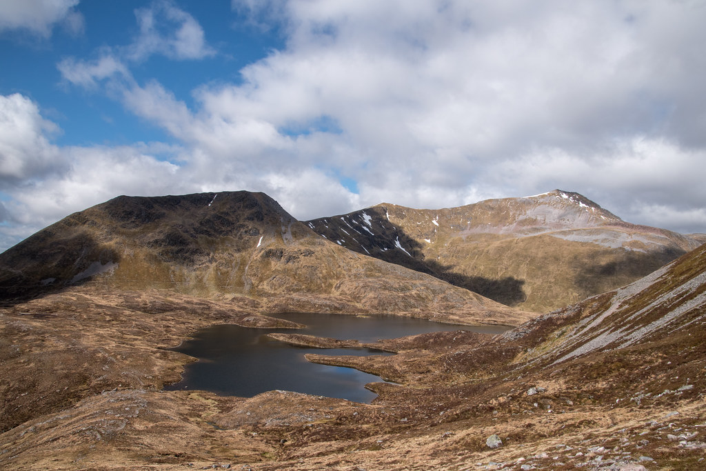 Looking south over Loch Eilde Mor towards Glen Coe
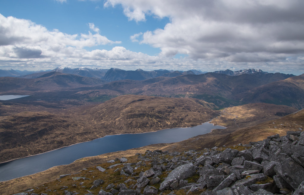
Everything was going swimmingly, but the south side of Sgurr Eilde Mor is a hefty boulder field for the last 100m or so. Everything was going swimmingly, that was until one loose boulder gave way which resulted in me smashing my shin into another boulder at approximately 1 billion miles per hour. Shins are very sensitive.
I am sure I let out a few profanities which unintentionally caught the attention of a group of young(ish) lads that had flow past me 5 minute earlier (with their very light daypacks I must add).
I took a short break to take some pictures, regain my composure, let the intense throbbing in my shin die down and just confirm that my leg was not snapped into two pieces.
I reached Sgurr Eilde Mor at 11:45 in a good amount of pain knowing I still had a long distance to go so I didn’t really hang about – I was paranoid about the dark and desperate to make camp long, long before dark!
“Tiny” hill on the right is Binnein Beag, Ben Nevis in background and Binnein Mor on the left
You lose a good bit of height from Sgurr Eilde Mor on route to Binnein Beag, far more than I had mentally prepared for. All of a sudden, the tiny hill of Binnein Beag, looks like a bit more of a sweat buster.
I really didn’t enjoy the route to Binnein Beag and was putting myself under a lot of pressure to make good time and was dafty considering bailing out without even attempting Binnein Mor and Na Gruagaichean.
Sense of the loss of height
By just after 13:00 I was at the summit of Binnein Beag and the views were simply breath-taking. It wouldn’t have been right not to take a proper break here and demolish the first of the 400 sandwiches I had packed for emergency outcome 1 to 100.
Looking towards Binnein Mor, my next target Towards da Ben
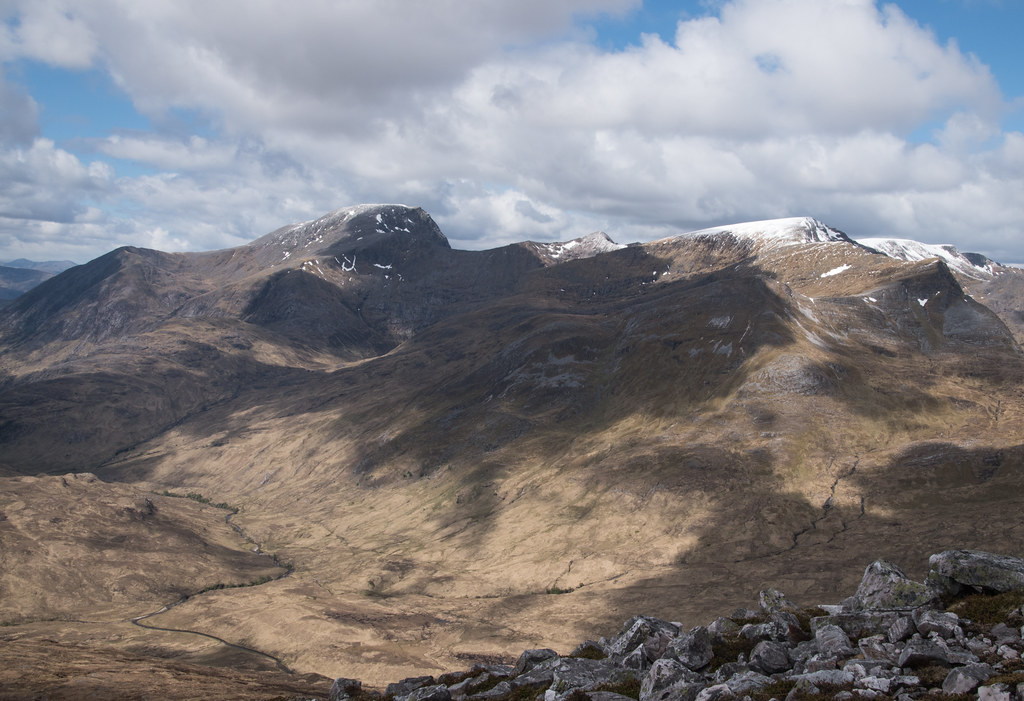 Alternative view of Binnein Mor
The group that had passed me earlier were also sitting just off the summit having a conversation that I got the impression they wanted not only myself but everyone in the Mamores to hear. I tried to ignore but did offered some help when asked to weigh in on their internal debate as to whether Ben Nevis, was indeed Ben Nevis. I felt like a bit of a snob – I thought everyone knew what Ben Nevis looked like? Tall?
They returned to discussing their day and their planned route to tackle Binnein Mor, the only section of the day I was still undecided about. Given the great visibility I had decided to make a decision based on how the day was going but my preference was a minor scramble up the most westerly shoulder.
Difficult to describe so here is a graphic Green
Green – my original plan
Pink – I’d love to do, but not carrying 70L and the kitchen sink
Orange – “100% the correct route as suggested by the summit others”
I always make my own decision when I am solo, or a group decision with others, but taking into account the past solo overnight outing I was airing very much on the side of caution by thinking that following others would be the best route.
Obviously, there is rarely a right or wrong route, but I was miffed that they hadn’t agreed with my plan, even although I was never part of their discussions, just very easily overhearing.
By the time I was nearing the point I had to make a decision the group along with 3 other solo walkers had begun heading in the “orange” direction when other two and their dog stopped and asked what I was thinking. I had bumped into these two earlier on Sgurr Eilde Mor and they had let their partners head back to the car whilst they would complete the four – this was reassuring that there was someone else doing the same route as me but 15-20 minutes behind me.
I explained my thought process for the best way up Binnein Mor and they agreed they’d follow my route up the green side, and jokingly advised that’d give Mountain Rescue a quick heads up if I had taken a tumble – legends.
I could help but keep looking at the purple route – Sron a’ Charbh-Choire on OS maps, thinking I’d far rather be scrambling up that!
Anyway, the green route was fun and easy enough with the large pack. Only a few sections where “hands on” was realistically required, and even at that it was more just for balance.
Heading left then curving around to the summit on the right
Once just off the summit from Binnein Mor, the views in all direction are insane, near perfect actually. In one direction you have the towering block of Ben Nevis, the view down the ridge to Sgor Eilde Beag and out towards Glen Coe, and most impressively the views towards the Ring of Steall and rest of the Mamores.
Towards Glen Coe We are very small
 The Ben
 Views from summit spot on Binnein Mor
 The Ring of Steall
At the summit of Binnein Mor I hadn’t seen the group that had taken the orange route, nor could I see them on route to Na Gruagaichean. I took my time heading up the green route savouring the views and taking a million photos, so I’d assumed they’d be well ahead of me. After about 15 minutes resting on the summit the group finally passed and seemed intent on making quicker progress to Na Gruagaichean and down to the car. They seemed phased that I had reached there quicker, moaning that it was a very hard slog the route they took.
The views down from Binnein Mor towards Binnein Beag are amazing. Although there is only 187m in height difference, Binnein Beag appears astonishingly small.
Small?
Just as I was about to set off the other two that had followed myself up the green route arrived with their incredibly energetic dog. I stopped and chatted with them for 15 more minutes, engrossed in their interesting chats about various hills – so if you happen to be from Inverness(shire), walking with your neighbour and their dog in the Mamores on the 11th May – it was lovely to chat!
We discussed my planned camp and the reason for the insanely large backpack, and they seemed convinced spending the night would be the correct decision, however the appeal of a cold beer was an even more correct decision for them!
The route from Binnein Mor to Na Gruagaichen is probably the easiest section of the day and as it was only just after 15:30, I knew I still had plenty of time before dark, removing one worry.
Heading towards Na Gruagaichean (left) On route to the 1041
  Summit view from Na Gruagaichean
The summit of Na Gruagaichean was slightly windier than the rest of the day and there was a larger group I had briefly bumped into on the previous summit, so I didn’t hang around at all, heading off down towards Leachd na h-Aire on the OS maps.
I was confident I would be able to find a good flat pitch and kept walking as the wind changed every 10m.
Good spots, too windy. Bad spots, no wind. Typical.
Eventually after a bit of back and forth I found my spot and committed
The only downside was the spot I found was right next to the main route of the hill and with it being so early I’d inevitably have the same / similar conversation with everyone passing. Maybe it’s not a downside but stops the true sense of isolation. For now.
It was very warm out of the wind and even warmer in the tent, I was already struggling to stay awake.
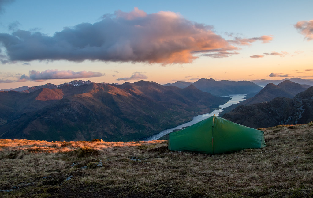
Just after 17:00
Just as I decided I’d get a couple of hours sleep before waking for the sunset and then again during the early hours of the morning, the tent got absolutely battered by hail stones. It was impressive listening to the frozen pellets bashing off the outer tent - I was glad I had the shelter of the tent and not just the bivvi.
Thankfully, the shower only lasted 5 minutes top.
A photo of the suspect hail hitting the Ring of Steall before my tent 19:49 – checking how sunset was getting on, and placing the tripod
 Sunset (21:07)

Almost ashamed to admit it but I really didn’t stay out long enough to appreciate the sunset. I was exhausted and not really interested. I took maybe 10 minutes to get the photos I wanted before heading back into the tent setting and alarm for 01:30.
I fell asleep instantly. Whacked. Cream crackered. The physical effort of this walk really wasn’t near my top 25%, but I must have been so uptight that the mental tiredness also translated into being physically zonked. My shoulders were in bits.
I slept well, hardly believing my alarm when it went off at 01:30. I was tempted to go back to sleep, but after a quick nosey out of the tent, it looked clear, very clear. It was nearly identical to the last night I’d spent in the Mamores on the Ring of Steall. How many people can say they’ve spent two nights up there in such good weather?!
I love very few things more than being slightly colder than I’d like, putting on sweaty shoes and trapesing across a hill from tripod to tent under the light of a headtorch only to realise I’d left the lens cap on for 8 shots each with a 25 second shutter.
Once I’d removed the cap - what a night


After over an hour I decided to call it a night (again) and made my way back into the tent to enjoy the traditional quick squint at the photos on the camera screen. Near certain you’ve got the best picture you’ve ever taken, knowing full well that you can’t really appreciate how good (or bad) any photo is until it’s on a full computer screen.
I was annoyed even with pre-knowing the size of the moon that the light population would make getting any good photos of the stars near impossible without layers and layers of Photoshop editing. As it turned out photographing the moon was my favourite part of the entire walk. Something I’d never really considered before. The only negative was I messed up by moving the tripod and not fully tightening the legs, only realising when taking the tripod down. I think this resulted in the photos on the moon coming out less sharp than I’d have hoped. Now I just want a really great zoom lens…
I woke at 07:30, excited to try and get down and back in time to watch the football – thankfully I missed it… 12th May 2019.
I missed the football mainly because I spent too long getting off the hills, and rightly so, the views were just as good as the previous day.
Gooooood morning A long way down
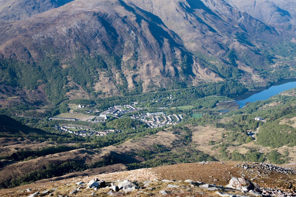
The route down from Leachd na h-Aire at 880m to 352m is horrible. There is no other way to describe it. Brutally steep and uneasy under foot. With my tired legs I spent a few times sliding down onto my bum, nice and cushioned landing with the monster backpack!
The views down Loch Leven which was acting as a mirror in the non-existent wind made the descent slightly more barrable. Only slightly.
Mirror Loch Seat with a view – also very easily accessible for most from Kinlochmore
I had started to work up a good heat and didn’t pass my first person until I was down into the woods nearing Kinlochmore. I still enjoy that look of bemusement from someone who sees you coming off the hills before most are even out of their bed. It’s often as if you have annoyed their peaceful morning where they’d inevitably expect to see no one.
Bluebells in the woods
I still hadn’t decided if I’d head to the Grey Mare’s Tail Waterfall or not, but as I was down nearing Kinlochmore and had no idea when I would next be in this part of the country, it seemed insanely daft not to.
I’d imagine the route into the waterfall would be nearly impossible in spate, or for those less confident on their feet. There was a good solid mental rope railing bolted into the rockface to hold onto and wooden planks to balance along, but it still felt uneasy with a large backpack – hence why I got no photos of the route in.
Once I had reached the opening with the waterfall, it’s clear to see why it’s a popular attraction. Although thankfully, not too popular meaning I had it all to myself.
It was particularly noisy. A strange change from the rest of the weekend, but at the same time eerily quiet – very hard to describe. It almost seemed a bit mystical / haunted, or maybe that was my body saying I needed my morning caffeine intake?
The Waterfall

There must be an outdoor activity company that have placed various routes up the side of the rock face and towards the waterfalls – I’d hazard a guess it’s something to do with the ice climbing facility? The bolts and overhead walk ways all appeared to head towards the waterfall and nowhere else. In the depths of winter maybe it’s a great ice-climbing venue? Thankfully the start of the route looked heavily fortified and included CCTV to stop anyone going for a solo jaunt.
Bolted section
After a brief morning rest at the waterfall I made the short journey back to the car where it was already brutally hot, far hotter than the day previous, or maybe it was just that my sunburn was beginning to radiate…
That drive back I felt on cloud nine (with the exception of a very bruised shin). This really couldn’t have gone much better, and I am glad I didn’t make any excuses, and I am even more glad I have finally got around to putting this Walk Report together – one I am sure I will look back fondly on, for a long time to come.
Nothing worth forgetting about this night. The Mullardochs are cursed, but the Mamores are magical!

Thanks for reading!
Andy
