free to be able to rate and comment on reports (as well as access 1:25000 mapping).
Grim Biscuits were a band from my hometown back in the early 80s. I can't recall ever hearing their music, but the name came into my head during one of these walks this weekend and seemed apt

With the start of the hill-slaughtering season almost upon us I was aware that stalking and grouse shoots might well impinge on the attainment of summits, especially Simms. A last chance for the wild wanders then, or so I had planned. An Dun & A'Chaornich followed by Beinn Vuirich, then a wee nip up to Braemar for Carn a'Drochaide and Morrone was the plan. We set off, driving through Glasgow in rush hour for the first time in ages on Thursday afternoon and arrived at the turn off for Trinafour sometime after 8pm. (Although this is where the WH route suggests parking, there is a proper layby on the southbound A9 immediately at the start of the walk - so if arriving from the south, turn left into the Trinafour road, then double back across the dual carriageway and park up). The walk in is pretty easy going - you could bike it quickly if that was your wont. Anyway, I'd planned to camp just shy of Sronphadruig Lodge and leave the tent up during our walk the next day. We arrived at the beginning of the deer fence, just under Meall na Spianaig as the light was fading, just enough light to pick a suitable flat spot, a bit nearer the track than I'd wanted, but we didn't have the luxury of looking about now - how quickly have the long light nights faded away?
Not expecting to be disturbed, we were a bit surprised to hear a shot, near by, sometime before 11pm. Then a Landrover came by, having transfixed the tent with its spotlight. No more bullets, thankfully

After that, the only sleep-disturber was a stag barking nearby sometime in the middle of the night. Friday dawned - a driech day with cloud down over the hilltops and drizzle from the word go. Delightfully, I found I'd forgotten to pack any breakfast (we usually have sandwich thins spread with Biscoff). Had to use oat bars instead, depleting our supply of those. I'd drawn a route up An Dun, then heading to its west, where we'd do three Simms before dropping down off Bruthach na Craoibhe to use the footbridge to cross the Allt Loch an Duin - I reckoned with all the recent rain we'd struggle without bridges today - then up to do a couple of Simms east of A'Chaornich before heading over the latter and back to the tent.
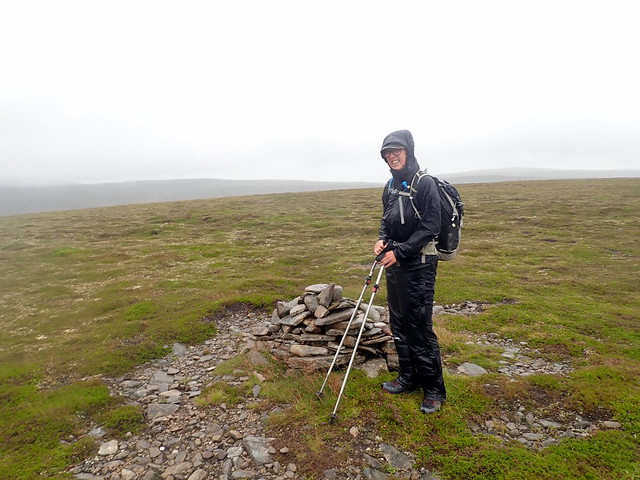
Setting out
 P8090391
 by
Al, on Flickr
It was pleasing not to have to lug all our kit around, after recent weekends of having to carry the burden. We took the usual way up An Dun, having decided not to bother with the Simm of Am Meadar just by the tent (300m up then immediately down again). An Dun is relatively easy going - deer paths help although it is boggy at the start. On the summit plateau we were struck by just how cold it was - waterproofs wet and being harassed by a strong, chill wind. Being unsure which of the two 827m cairns was the true summit (hint - it's the southernmost one) we went to both, before dropping steeply down into Coire na Craoibhe and making for the first of our Simms. Pretty unpleasant going - very wet underfoot, mist down over everything and the bitter cold of the wind - eventually had to stop and put on belay jackets under our proofs. I was regretting not wearing my winter Paramo waterproof trousers.
An Dun top
 P8090392
 by
Al, on Flickr
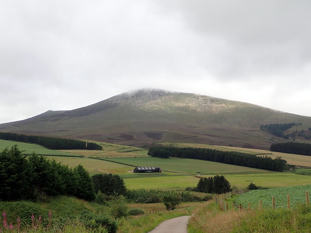
Towards Loch Bhroadainn
 P8090393
 by
Al, on Flickr
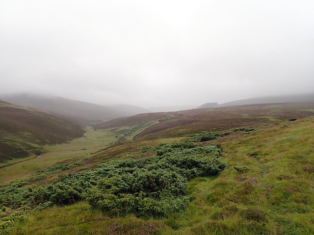
We paused between Meall Odhar Mhor and Bruthach na Craoibhe for something to eat - managed to get my jetboil to work despite the wind - an a warming cup of herbal tea was most welcome. Then an intensely steep descent on heather down to the footbridge. Just as well we were crossing here - the river was in full flow and I wouldn't have fancied crossing it unaided. There's a pretty, flat area with some trees south of Loch Bhroadainn which would have made a nice camp spot. In fact, despite the weather and the curtailment of views, I think the Gaick Pass is a lovely place, with dramatic steep sided mountains. Would be appealing to walk the length of it one day.
Down off Bruthach na Craoibhe
 P8090395
 by
Al, on Flickr
Our way ahead - A'Chaornich on the right of the stream, Bruthach na Creagan on the left
 P8090397
 by
Al, on Flickr
Making for the bridge
P8090397 by
Al, on Flickr
Glad it's there
 P8090398
 by
Al, on Flickr
Lovely spot
 P8090399
 by
Al, on Flickr
Our way from here was up the steep side of Bruthach nan Creagan, the first of our two Simms on this side of the pass. Not quite as steep as the previous descent, but still effortful. Then onto plateau, more wind and rain. We reached the summit, then I hesitated to say to Allison we were going to do the hill to the east, Leathad na Lice - a drop of around 150m, all of which had to be re-gained. She set her jaw and proceeded like a trooper. More wet squelch, another summit, then back the way we'd come, before crossing over to the final peak of A'Chaornich. Still raining, cold wet and miserable. It's another few kilometres down from here - I had routed us over Meall na Spianaig, but as we'd already climbed that one last time it made more sense to take the deer trail that heads obliquely down to the end of the deer fence and our tent, which I was relieved to see was still there.
Another Simm to visit
 P8090400
 by
Al, on Flickr
Summit A'Chaornich
 P8090402
 by
Al, on Flickr
It was getting on for 6 by the time we arrived back at our small haven. I'd intended to have our tea then pack up and walk out tonight, but Allison looked completely shattered so a change of plan was going to be needed. Beinn Vuirich was just shy of 30km the way I'd routed it - there was no way we'd manage that tomorrow along with a 8-9k walk out in the morning from here. Anyway, the main thing was to get a restful night - after a somewhat meagre tea we settled down to sleep and actually had a really good night's slumber.
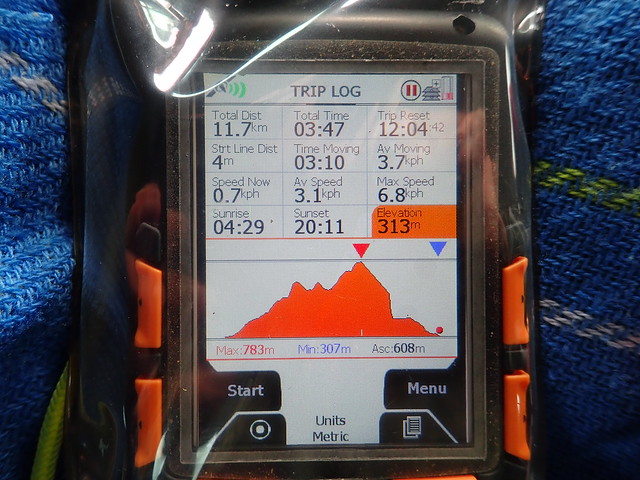
Includes the walk out
 P8100404
 by
Al, on Flickr
Saturday morning was still and dry. The ground was soaking from all the rain and the midges were out in numbers. Putting the tent away was murder - the air was thick with their black bodies. Once we were on the move it wasn't so bad. We'd risen early and were back at the car just after 8.30am, having met a chap on a bike going in to do the two Corbetts - we gave advice about the state of the river. What to do...well maybe Carn a'Drochaide and Morrone - but that would be over quickly...alternatively we could head further north and do Ben Rinnes and Corryhabbie Hill - short and easy enough even for a somewhat crocked Allison. I chose the latter.
90 minutes of driving had us up in Glenlivet/Glen Rinnes and parked up to start the walk up Ben Rinnes. Last time had been dry and claggy - looked as though we were in for a repeat today. We were passed by several hill runners as we wandered up the good path. Hit the clag around 550m. Passed a French family lumbering up - I love hearing French spoken

Quite a few folk at the summit - stopped for a brew, hoping that the sun would break through, which it nearly did... Back down again in under 2.5 hours and a short drive along the road to Corryhabbie Hill.
Summit Ben Rinnes
 P8100407
 by
Al, on Flickr
 P8100408
 by
Al, on Flickr
We parked in a layby just before the right turn to Ellivreid farm. Had some crisp and juice, girded the loins for another walk. At least it was still dry and the mist was clearing - Ben Rinnes was now resplendent without clag. I wanted to add on the Simm of Carn a'Bhodaich which meant we went up the standard route, then cut off to the west from Muckle Lapprach (over quite boggy ground) before retracing our steps and heading up to the summit of Corryhabbie. I see the trig point has a nice hat. Rather than prolong the walk by following the WH descent route, which we did last time, we headed straight north into the coire - thick heather and hidden holes, plus a small river to ford at the bottom before regaining the track. Just under 4 hours for this one.
View to Ben Rinnes
 P8100409
 by
Al, on Flickr
 P8100411
 by
Al, on Flickr
Corryhabbie
 P8100414
 by
Al, on Flickr
Simm
 P8100415
 by
Al, on Flickr
Corryhabbie summit
 P8100417
 by
Al, on Flickr
 P8100418
 by
Al, on Flickr
What now? I wasn't sure where we'd spend the night. I reckoned we could maybe do Carn Ealasaid and Brown Cow Hill on Sunday - I'd drawn up a nice route of 34k that kept high over about 10 Simms - but we could also do them individually if need be. Could we camp somewhere at the Lecht? I couldn't remember really, so we headed down that way. Possible spot at the Well of Lecht, but occupied - as indeed were many of the possible sites - mobile homes standing guard. We got to the parking area at Corgarff Castle - there was another mobile home there but plenty of space to stop and cook our tea at least. The sun was out by now and we got the folding chairs out to ensure we enjoyed our tea in comfort. Quite a number of cars came into the car park - including two Italian families in rented Beamers who parked, read out the notice about the castle (presumably to their kids in the back) then drove out again.
We decided we'd just pitch our wee tent in the field in front of the castle - no animals in that one, though many sheep around to baa all evening. Finished our book (The book of Ebenezer Le Page) and settled down for sleep. We hadn't reckoned with noise of partying which seemed to come from the Briggie's Bothy or outdoor centre beside it...Anyway, got a reasonable night's kip. Up at the back of 6 again and packed away a wet tent - wind too strong for the midges this morning. The clag was down low, the drizzle on - not a day for a 34k high level walk! So individual hills it would be then. We'd do an out and back for Brown Cow taking the shorter WH leg, then use the track from Loinherry to head up Carn Ealasaid.
My intended route
What we ended up doing
Up through the castle grounds, struggling to find the track in the undergrowth and having an encounter with a sunken but swollen stream. Onto the track for a good bit then onto the hillside proper, where the track peters out amidst peat hags and general swamp. Difficult to keep one's bearings when the ground is level and you have to keep zigzagging around to negotiate layer upon layer of swamp. We finally made it to drier ground and the 823m cairn. I was more than glad I had put on my winter waterproof trousers today (yes, it's the 11th of August). Trying to find the 828m summit was hugely enjoyable in the mist and bog, but we made it. On the descent we took a parallel route, somewhat to the south of our ascent one - this proved less boggy but full of dense heather. Eventually back on the track - stopped near the bottom for an early lunch and were visited by a white ladybird.
Corgarff Castle
 P8110419
 by
Al, on Flickr
 P8110420
 by
Al, on Flickr
Erm....grim biscuits
 P8110421
 by
Al, on Flickr
Brown Cow
 P8110423
 by
Al, on Flickr
 P8110425
 by
Al, on Flickr
Beehives...with escaping bees?
 P8110430
 by
Al, on Flickr
From here we forded the stream and reached the road beside the famous Cock Bridge, which we were surprised to read was opened in 1991. Real historic then

. A short walk up the road, passed by a jamboree of Jaguars, turn in at the aforementioned Briggie's Bothy for a walk along a track to reach the landrover track that goes the whole way to the summit of Ealasaid. It wends round a bit, but is a fairly gentle approach to the hill - admittedly starting lower than if you tackle it direct from the car park at the Lecht. We passed a line of gross-butts, which probably will be in action tomorrow. After an interminable time in the clag we got to the summit cairn and could start walking back down the way we'd come.
Cock Bridge
 P8110431
 by
Al, on Flickr
Carn Ealasaid
 P8110434
 by
Al, on Flickr
 P8110435
 by
Al, on Flickr
Back at the car we stripped off some of our wet clothes and set off to drive back down the road. Heavy rain all the way, with a great deal of surface water on the motorway. We realised, belatedly, that Allison had got her 150th Corbett on Ben Rinnes. I was pleased with the six in a weekend - despite the grim biscuits weather

