free to be able to rate and comment on reports (as well as access 1:25000 mapping).
In my dotage, when I'm sitting by the fire, reminiscing about great days in the hills, I think it's safe to say that none of this weekend's adventures will feature. Which is a pity - we did, after all have a long weekend as Allison had Public Holiday Monday off ( I no longer have to consider such things) and in the past we've usually made use of the extra day for some kind of spiffing adventure. But this weekend the weather forecast was grim for pretty much the whole country, especially on Friday & Saturday with heavy rain and high winds. Plus I was nursing a new tattoo on my arm, which isn't the easiest thing to care for in the hills.
I decided we'd head off on Friday morning and pick off as many of the eastern Corbetts as we could. This task had been rendered more problematic by my discovery, midweek, that I hadn't done Creag Uchdag and Creag na Beinne twice - a chance conversation from my brother-in-law about the report I did on these hills back in 2015 made me think that I'd only been up there once - I clearly forgot to reset the "blue balloons" when I finished my first Corbett round (a task complicated by the fact of having done around 35 twice anyway playing catch up with Allison). So when I thought I was down to 26 left, I find I'm actually on 28

So that pair had to go to the top of the list to be re-climbed.
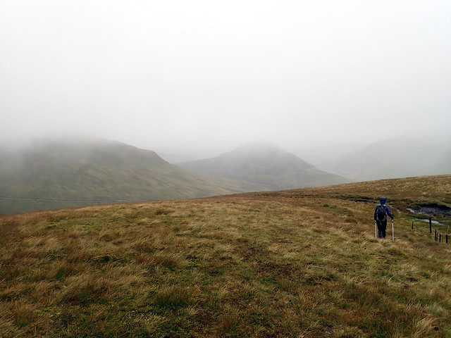
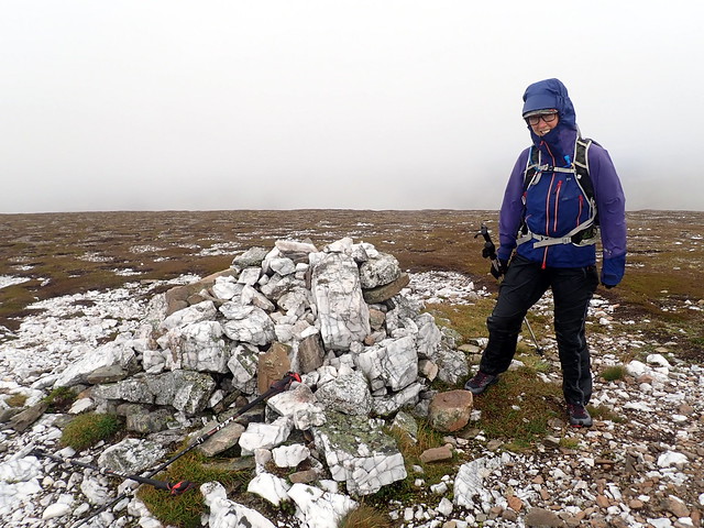
The weather was pretty foul when I picked Allison up at 7am - no view across the Clyde at all, rain and mist generally. I was excited as I had my brand new, just out of the box Satmap Active 20 (regular readers will recall i've been having problems with my GPS device recently). I had decided to see what these hills were like approaching from the north, as they were fairly tough coming up from Glen Lednock. So we drove along the southern shores of Loch Tay to Ardtalnaig, parking in a largish layby just west of the cemetary and set off into the misery. The first objective wsa Tullich Hill, reached via a faint track through the fields, fairly boggy. No visibility from about half an hour into the route, we connected with a fence line nearing the brow of the hill and kept to this for the next wee while, til we reached Meall nan Oighreag. Some diversions due to peat hags were required, and these became ever more frequent as the walk progressed. Creag Uchdag was summited and we made our best attempt at following the ridge line, such as it was over creag nan Eun and down to Meall Aiteachain.
Uchdag
 P8300077
 by
Al, on Flickr
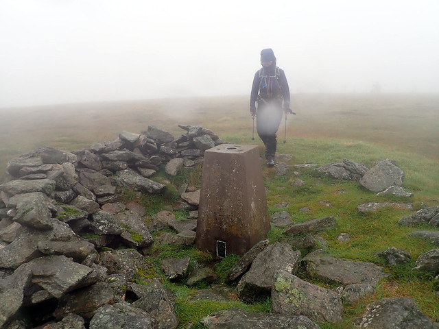
I made for the footbridge on the map, knowing that the River Almond would be a bit full today. Last time we'd used a different route, coming off Meall Mor and thereby avoiding the river crossing here. I reached the spot where the footbridge is marked...and obviously washed away some considerable time ago. Oops. We headed north along the riverbank to a place where the flow is divided into three - this made for an easier crossing. The rain continued, neither of us had much energy or enthusiasm but we knew we had to go back up almost 500m to the summit of Creag na Beinne. Sheep tracks and peat hags. On the crown of the hill there's a vague path and we reached the summit cairn in a state of some despondency. From here the route was along the back of the hill, aiming for the Simm of Beinn Bhreac then a fairly gentle descent back into the valley. Visibility remained very poor and the rain didn't let up. More peat hags to negotiate. Then disaster - my GPS unit, which had been performing beautifully all day, crashed and died. We were left to find our way off Beinn Bhreac by map and compass, me raging about the malfunctioning Satmap.
 P8300078
 by
Al, on Flickr
Once a bridge...
 P8300079
 by
Al, on Flickr
Creag na Beinne
 P8300080
 by
Al, on Flickr
Eventually we made it back to the car - by this time it's around 6.30pm and we are both soaked through. Plus we have no idea where we are going to spend the night. I try and anoint my tattooed arm with coconut oil as is my routine - but my hands are so cold that the oil won't even melt on them so I can rub it in. We eventually get it together and drive further along the south Loch Tay road, with little idea of where to go, other than heading for Angus, when I notice a cul-de-sac off the road which will, at a push, take the tent - it's clearly used for such purposes as there's a fire pit. We pitch onto stony ground, try and stave off the midges long enough to get under cover and have some quick food. A German maggot-van shows up later on, but the occupants make no noise overnight, so that's a bonus. It continues to rain.
Up at six and away Kirriemuir way - the roads nice and quiet at least, the rain still with us. I reckon we should do Ben Tirran first, as there's the option of camping up in Glen Mark after Mount Battock - I always like to have some idea of where we might be able to get pitched, and we've used Glen Mark several times now. So we meander through Blairgowrie and Kirrie, then up Glen Clova to Rottal. No Simms to do on this one, so I'd routed a quick up and down. Well that was the plan anyway.
We emerge into driving rain and wind. I've parked on the verge just by the metal gate opening onto the moor, and there's an ATV type track to follow up through the heather. There's a track coming in from Wheen then heading up the hill - that's the one we want to take, but it involves crossing a ford (not a footbridge as marked on the large scale map) and the river is in spate. And I get a bit mixed up, because there's a lovely track going off to the west and up Rough Craig - not shown on the map. But this is the wrong way - we sidestep onto a footpath of sorts heading up by the west of Loch Wharral, which will bring us to the fenceline to follow to Ben Tirran, as we did last time.
 P8310081
 by
Al, on Flickr
Typical view
 P8310083
 by
Al, on Flickr
Rain is finding my "waterproof" Paramo trousers no obstacle - water runs down the insides of my legs and into the inside of my waterproof Dexshell socks, which up til now had been doing a good job of keeping my feet dry. Yes, it's a miserable morning. We reach the summit trig, follow a deer path off the wrong aspect of the southern shoulder in the clag and have to make corrections to eventually join the track. Given how wet we are, a wade across the ford to head back to the car doesn't seem that bad - until we look at the force of the water flowing and decide maybe not...so we head the opposite way along the track coming out at Wheen then walk back along the road. By this time not only has the rain stopped, but the sun is actually shining

Not that it lasts... We have a cuppa and lunch at the car then set off for Glen Esk for the most easternly Corbett of Mount Battock.
Tirran summit
 P8310084
 by
Al, on Flickr
Oh yes, sunny now!
 P8310085
 by
Al, on Flickr
 P8310086
 by
Al, on Flickr
I'd drawn up a lengthy Simm-bagging route for this one, which obviously we were not going to follow today as it was around 30k in length. Nope - a straight up-and-down will do us. We park beside the phone box, just past Millden Lodge - there's plenty space there. Rain seems mostly absent, though never far away as we start off along the road, past the estate buildings and the mental barkign dogs at Muir Cottage. Teams of immature pheasants loiter along the track, ineptly moving out (and sometimes into) our way as we walk along. The hills have a lovely purple glow from the heather. We come to a split in the track on Allrey Hill (track up by gross butts not shown on map) and once again I take the wrong way, heading up Allrey Hill rather than continuing round to the east. We pass very up-market gross butts, like miniature castle turrets, ego-soothing to the knobheads who go in for this "sport" no doubt. I'm assuming the tracks will join up on the other side of Allrey Hill, but they don't and we are forced to rough it over heather, crossing Black Burn to regain the track going up towards Mount Battock.
 P8310087
 by
Al, on Flickr
 P8310088
 by
Al, on Flickr
We reach the trig and take shelter in the windbreak to consume a bite of food, before setting back down,just taking the route we used on the ascent (with the exception of the diversion over Allrey Hill

). It is actually quite a nice evening now, the heather's glow illuminating the surrounding hillsides. Back at the car we decide to head further up the glen to Invermark, where there are several maggot-cans parked up for the night. I cook the tea in the open boot (getting quite good at this) and we eat in the car before pitching the tent down by the riverside. A nice quiet night, apart from someone's car alarm going off twice around 4am - I can't get back to sleep for a while in case it's us that's been burgled although as the alarm only sounded so briefly I guess it's not an issue.
 P8310089
 by
Al, on Flickr
Battock
 P8310091
 by
Al, on Flickr
 P8310092
 by
Al, on Flickr
 P8310095
 by
Al, on Flickr
Up again at six, breakfast in the car (which is undisturbed) and then a drive to Morven. It's a nice change to be blinded by streaming sunshine instead of sheets of rain as we head back down Glen Esk and up to the A97 via sweet, sleepy Fettercairn and Clatterin' Brig. By the time we park up at Bridgefoot clouds are massing again and little spits of rain come out of the blue sky.
I'd also drawn up an extended route for Morven, taking in the two Simms to the south. However, this too went out the window - all that mattered was getting these bloody hills done - we had Carn Mor to fit in this afternoon. I remembered this route well from our last jaunt - that report had the landscape peopled (if that's the right word) by zombies and vampires. Well, none of that today, just a fairly bearable walk up the gentler of the two approaches shown in the WH route and back the same way. Boy it was chilly up top - a blast of northwesterly air keeping us cool. As on all the other hills this weekend, we saw no-one else.
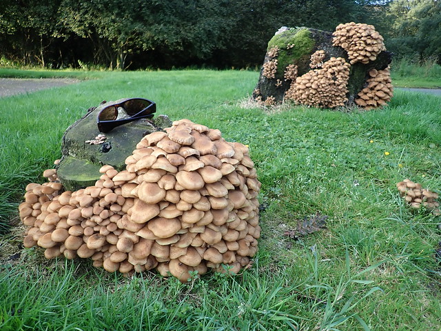
Impressive mushrooms at Invermark carpark
 P9010096
 by
Al, on Flickr
Morven
 P9010097
 by
Al, on Flickr
 P9010099
 by
Al, on Flickr
 P9010100
 by
Al, on Flickr
 P9010101
 by
Al, on Flickr
 P9010102
 by
Al, on Flickr
 P9010103
 by
Al, on Flickr
Back at the car for lunch then a drive along to the Lecht, the starting point for our walk up Carn Mor. I remember the route from Chapeltown having some epic peat hags and fondly imagined a high level romp along the hilltops from the lecht would be fairly pleasant. Hmm. it was very windy as we left the car at the ski station and headed up by the ski rund on the north side of the road, just by the wooden chalet-type building. Starting at 650m to do an 803m Corbett - oohwee! But of course it wasn't going to be as easy as that....
The climb up from the ski centre to the first Simm Meikle Corr Riabhach was ...quick! Then the fun (not really) started - peat hags, bog and tussocks. None of the firm underfoot ATV track I'd been hoping for. We squelched along, following the fenceline over Carn Liath. For some reason I'd convinced myself that the next summit was Carn Mor - Allison was surprised "it's not that big lumpy thing after it?" but I realized my error when there was no trig point (as advertised) on the top of Monadh an Sluich-Leith although I could see one over on the next hill...what's another 2.6km when the wind is blasting you and the rain is intermittently battering you too? We made it to the trig point, retraced our steps and finished with slightly less distance and elevation required than if we'd come in from Chapeltown. Of course - once again the was meant to be part of a bigger route, one that took in Brown Cow Hill and Carn Easalaid, but was abandoned due to poor weather conditions a couple of weeks ago. It was also my 200th Corbett, although I didn't realise it at the time.
 P9010104
 by
Al, on Flickr
 P9010105
 by
Al, on Flickr
 P9010106
 by
Al, on Flickr
Carn Mor
 P9010108
 by
Al, on Flickr
The way back
 P9010109
 by
Al, on Flickr
 P9010110
 by
Al, on Flickr
Where to now? I'd seen a spot that looked ok at the Well of Lecht when we'd driven by last time. i reckoned we should check it out. There were two maggot-vans already in situ, one with a log burner inside (jammy sods) but we found a couple of useful spots for a tent down beside the river. Once again the cooking was done in the car boot, with the unfortunate accompaniment of midges on this occasion - I lit some incense sticks which seemed to keep them mostly at bay.
We bedded down for the night, which was a cold and wet one - I woke in the wee hours and found the outer of the tent entirely encased in ice. We were at an altitude of 450m, but even so - it's September the 2nd

I'd noticed the leaves on the trees starting to turn in the last couple of weeks, but that's it - summer is definitely gone. Only residual shards of ice were left by the morning, when once again we were up at six. A few miles along the road to Dorback Lodge for our last walk of the weekend. I hadn't enjoyed this hill the first time round - would it be any better today?
Once again, neither of us had any particular enthusiasm for getting started. The midges - which had been absent earlier when we ate breakfast - 3.5degrees thankfully too cold for them - were now out in force in the warmer (8 degrees) climate around Dorback. We set off, planning on doing one Simm (revised down from my earlier, more optimistic idea of two). The derelict Dorback lodge is melancholic - the mad barking dogs at the modern cottage next door noisy, especially the howl of disappointment they let out in unison after we had passed by. Either they wanted feeding, or were mourning the fact that they hadn't devoured us. Along the track, slowly gaining height. Pretty tedious. Carn na Farraidh was climbed (more peat hags, bogs and an interesting challenge to get to the summit, which is completely carved out of peat hag all the way round). We returned to the path via budget gross butts, which looked rather like pallets turned on their sides - not the upmarket variety seen at Mount Battock. Then up the side of Carn Mor - first on peaty ATV track then pathless over tussocks of heather. Mist had descended, taking away even the pleasure of some scenery. The going became easier once we reached the broad back of the hill, but the wind was still cold and strong.
Dorback Lodge
 P9020111
 by
Al, on Flickr
 P9020112
 by
Al, on Flickr
The excitement of Geal Carn
 P9020114
 by
Al, on Flickr
 P9020116
 by
Al, on Flickr
 P9020117
 by
Al, on Flickr
From the top, down the standard WH route, rather than the deviation over Carn Bheadhair I'd originally planned, a skitter finding the track and crossing the river then back at the car. We had no lunch with us (I'd left my lunchbox with one day's lunch at home) so we made do with crisps and a slice of pie and custard before heading back down the road, early enough to miss most of the heavy traffic through Glasgow. A rather scunnering weekend - partly due to the weather, but I'm also sick of doing rounded featureless hills in the East - it seems like ages since we've climbed a proper west coast hill. Bring it on

