free to be able to rate and comment on reports (as well as access 1:25000 mapping).
If you'd been walking south from Tomintoul along Glen Avon on a late July morning a couple of hundred years ago you may well have come across herds of these bonnie creatures being driven south down from the pastures of Aberdeenshire and Bamff to the trysts at Crieff or Falkirk.

OK, so these are modern descendants from the Irish side of the family - but you get the picture

We'd been pondering a route into the two Munros in the eastern Gorms for a while before Roger admitted he'd always fancied walking from Tomintoul to Braemar via Glen Avon, so we came up with a plan (or rather he did). Day 1 walk in from Tomintoul to Loch Builg, camp; (very authentic, drovers would have camped here too). Day 2 tackle the 2 eastern Gorms following a path from Loch Bluig we could see on the OS Explorer which would take us close to Clach Choutsaich. From there it would just be a hop, skip and jump to the summit of Ben Avon and then on to Beinn a'Bhuird via the Sneck, then we would just have to retrace the route back to the tent. Day 3, walk out to Keiloch on the Invercauld estate and pick up our car. Nice wee 3 day trek

, The only problem was how to organise transport - we wanted to leave the car at the Keiloch car park but then how were we to get to Tomintoul? In the end our daughter agreed to spend one of her non-working days ferrying as from the end of the walk to the start, and to look after the dogs while her aged parents tried to recapture the youthful joys of backpacking


The route of the Drovers Return, just under 56K and 2550m ascent

.
Now all we needed was three consecutive days of good weather, in Scotland in July, that fitted our daughter's work roster. In the end we opted for a Met Office prediction of a good day, an just about OK day and a deteriorating day.
Day 1: Bags packed, car left at the car park so our daughter drove us to Tomintoul and deposited us at the Glen Avon car park on the outskirts of Tomintoul not far from Queens View.
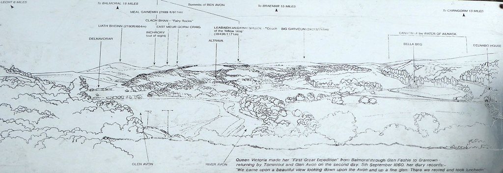
You've got to hand it to Queen Vic, she picked some bonnie spots for picnics - well her staff did.
Queen's View

as it is today, with its own interpretation board.
It may have been late July, but these spring flowers didn't seem too concerned about seasons


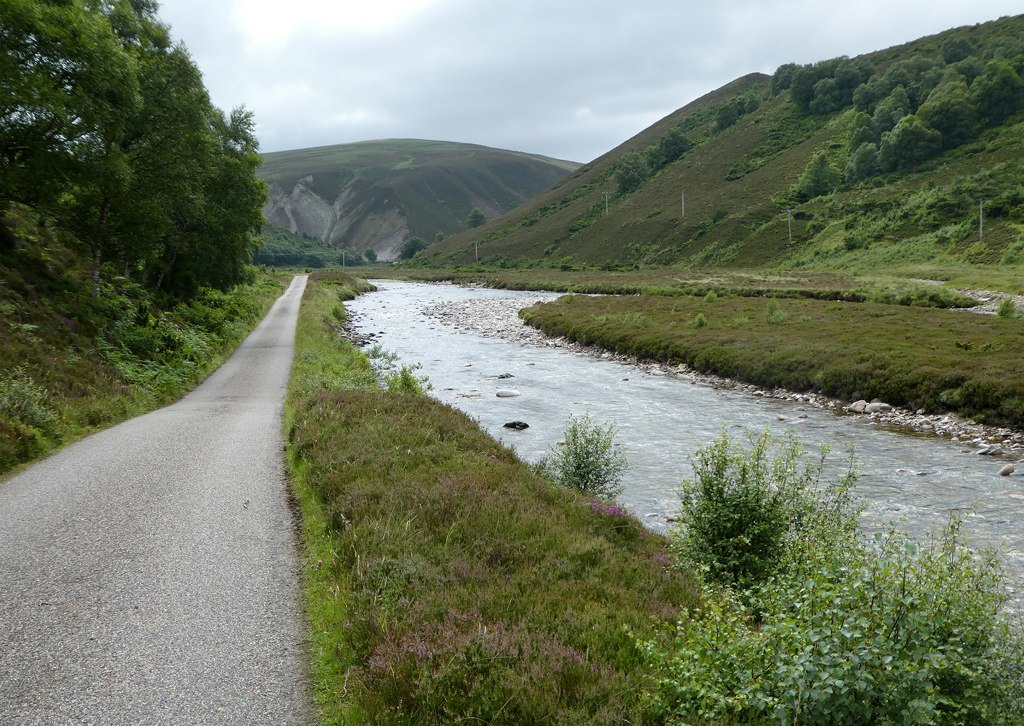
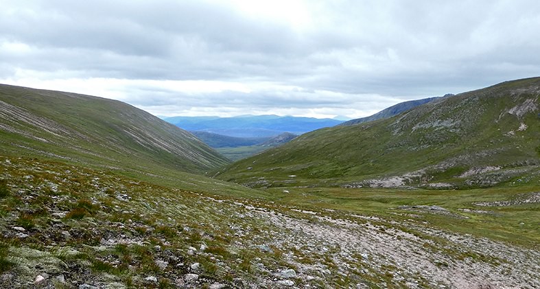
On a sunny day this section of Srath Avon made attractive easy walking, for anyone intent on nipping up Ben Avon and back in a day then a bike and hike trip would be ideal.
River Avon

After a few kilometres we came across this group wandering down the glen with no drover.

We initially thought they would all disappear of to the right for what looked like good grazing, but no, the 2 who went right were rounding up the rest of the group. The drove was on
The cattle were content to be driven down the road for what felt like a considerable time. Despite the horns they didn't appear aggressive or threatening at all, in fact their body language seemed to suggest we were the ones to be afraid of

We passed the bridge to Easter Gaurig

and were just wondering how we might explain why a couple of geriatrics were driving cattle down Glen Avon on this bonnie morning
. If we met their owners would they confuse us for rustlers - that might be uncomfortable

The drove goes on - calmly

and eventually the cattle got to where they wanted to be
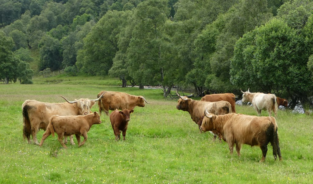
We left them not quite knowing whether they should have paid us for our skills as drovers, or we should have paid them for giving us "The Drover Experience"

. But with hindsight we were probably just going in their direction anyway
.
The landscape was gradually getting more hilly, but the path remained the same well made landcover track we'd started on.
.
Eventually we found a convenient bend in the river with some shore to stop for lunch and laugh about the Droving Experience.
Looking north along the Avon from our lunch spot.

There is a lot of tree conservation, regeneration work in this area of Strath Avon which make for a very attractive walking route. Once we reached the confluence of the Avon and Builg Burn we continued south along the Burn along a rougher (but still good) path. The better path continues west alongside the Avon. The west route along Glen Avon give another line of access to Ben Avon, and also a route into the Caringorm massive.
The confluence of the Avon and Builg Burn, the route along Glen Avon continues over the bridge, we were heading straight on by bearing to the left in the photo.

The path got rougher

and the odd rest was required

We passed someone upgrading the path with a digger, but whether this was part of conservation or stalking works I don't know. We passed this bonnie wee plant, but I have know idea what it is, can anyone tell me?

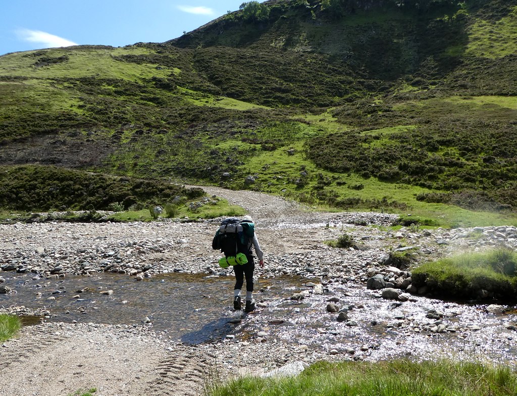
There were a couple of places where we had to ford the Builg Burn, this was the first and easiest, but neither were tricky that day.
By the time we reached the north end of Loch Builg the path was muddy and narrow, but then in the middle of what looked like a wild place we spotted a sign which kindly told us where we were

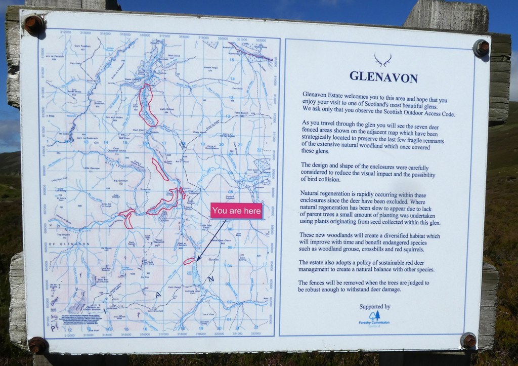
To be fair it also told us more about the conservation work being carried out on the Glenavon estate. I think the post also was on the boundary of the Invercauld Glenavon estates. I found it strange to see such a poster in the wilderness and it certainly made the area feel less remote, as if visitors were being catered for. For someone who doesn't live locally an notice board like this is informative. I've since seen similar notices elsewhere describing peatlands restoration projects and wildlife management. The could of course be a requirement of the funding body, that recipients must 'inform the public' about their conservation work.

By now Loch Builg had come into view, looking very fetching in the afternoon sun ... but the wind was a tad chilly to be tempted by its waters

Across the Loch on the skyline we could just about make out the line of tors on Stop an t-Sluichd (I think)

Loch Builg and its island

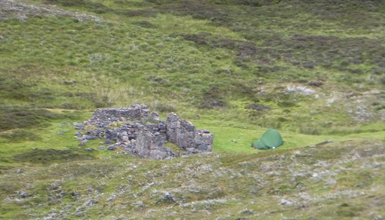
We were heading for the south end of the Loch for a camping spot. In one of Malky_c's reports he talks about the south end of the Loch looking pretty boggy, but we'd spotted a ruin of Lochbuilg Lodge on the map so we were pinning hopes on that providing a dry camping spot.
Lochbuilg Lodge - clearly has seen better days ...

... but was to prove a great camping spot. Another camper set up tent on the opposite side of the ruin and later disappeared to talk to a larger group camped closer to the Loch. We found out later that he was a DoE trainer/assessor and the other group were the students he was responsible for. He also updated the weather report for us. The following day would be misty to begin with but would improve (in line with what we'd expected) but then it would deteriorate quite rapidly in the evening. The following day (our walk out day) would be dire. The instructor seemed quite sorry for the conditions his group would encounter, I did not find that encouraging
. We figured we needed about 6 hours decent weather at height the following day to visit both munros and see the sights. This should still be OK - just.

As for the walk out - best not think
Day 2: Woke to a misty morning, breakfasted and generally got ourselves ready for the off. We could see the DoE candidates also getting themselves ready for the march round to Glen Avon.
DoE group heading north along Loch Builg (taken from the missing path)

Home for the coming evening (taken from the same spot)
The path we wanted to follow was more evident on the map than on the ground. After some casting around we decided to follow the general line which would take us south west round the foot of Carn Tiekeiver and Carn Drochaid, before heading west north west then due west to follow the line of a gully which would bring us onto the ridge from which we expected a gentle stroll to Ben Avon, or Leabaidh an Daimh Bhuide.
I must be honest it was a gentle way to gain height, although the tussocky heather was more work than a decent path
. We must have startled hundred of mountain hare, I don't think I've ever seen so many in one place. Occasionally we did find the path, although obviously reverting to nature.
Is this the line of the path?

At time path following was like a pantomime - "its over here", "no it's over there" "its behind you". But even without a path it was a fine walk. The mist was lifting; we were convinced the weather forecast would be right (not because we were convinced by the weather forecast, but if we didn't believe it WHAT WERE WE DOING HERE????
) When we got to Carn Drochaid we decide to go to the summit to get a better sense of the lie of the land, and from the summit, what did we spot. The path, and not just any old path, but an excellent stalker's path heading exactly where we were aiming to go
.
The path carried us up to a waterfall about 3/4 the way up the gully we wanted to climb by the side of the Alt Phoupie.
View from gully looking back along the route we'd taken. The hill is (I think) Culardoch, part of our route out the next day.

The mist was continuing to lift and as we neared the ridge we met the reception party

Unlike the cattle of the previous day, this lot made it quite clear they did not need drovers and cleared off.
Although the mist was still tipping the top of Ben Avon occasionally, there were enough breaks to make us believe this was all going to plan.
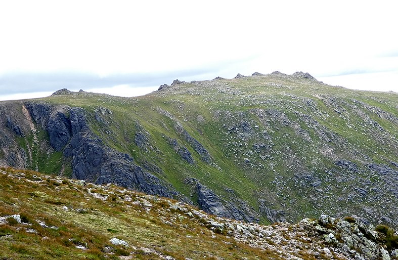
Clach Choutsaich (I think)

Over to Ben Avon with West Meur Gorm Craig over to the right

The tor of Ben Avon itself, with the mist finally clearing

We were soon at the foot of the tor, I went up first in order to capture Roger's ascent
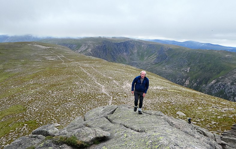
Retaliation

Looking north east ...

... and through the notch of the tor, looking south west towards the Sneck and over to Beinn a'Bhuird

There was now quite a strong wind blowing from the south so we, along with a tribe of midges, settled down behind the tor for lunch
. Middgy attention meant lunch was fast and we set off along the clear path towards
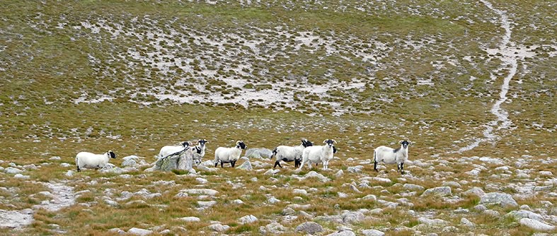
Sheep
sheep at munro height, they were close enough to be contemplating a climb up the summit tor
We had the wide, sweeping views so characteristic of the Caringorms, although my photos don't do justice to them.
Looking south down Gleann an t-Slugain and the more usual approach to Ben Avon.
Beinn a'Glo

The Sneck and the route to Beinn a'Bhuird

We did meet several other people at this point, but even so it wasn't crowded
It must have been around here that catastrophe struck
. Roger suffers badly from sunburn so hides from the sun under a very comfortable panama hat. There hadn't been any sun today so the hat was rolled up and tucked in his rucksack, but it wasn't his normal day pack which has zipped outside pockets, it was a backpacking sack with no closed outside pockets, so the hat was just sitting in an open outside pocket

. At some point the call of the wild must have become unbearable for the hat, which was after all used to seeking the wild from the top of Roger's head. The hat made its escape. Neither of us saw this happen but when I checked the photo of Slochd Mor ... yes there was the runaway

Not realising what had happened we gazed longingly at the tors of Stob an t-Shluichd - it would have bee great to take some extra time to visit them, but we were aware that the forecast was for the cloud to come back down around 6ish, and we wanted to be off the heights and heading back towards Loch Builg by then. So another time for these beauties
We trekked across to the north top of Beinn a'Bhuird, chatting to a couple of other walkers who were on their way from a'Bhuird to Avon. We were to meet them again when we retraced our steps heading back the way we'd come. What can I say about the north top of Beinn a'Bhuird - its a cairn, surrounded by a path on a plateau with amazing views
.
Roger sans hat sitting by the cairn

The southern route off Beinn a'Bhuird

We retraced our steps as the weather gradually became more threatening. It must have been about 5pm when we got back to Ben Avon, looking dramatic against a darkening sky

We got to the ridge with the tors where we'd seen the deer in the morning and headed down one of the gullies in the direction of Carn Drochaid. We did find a path, not quite as good as the one we'd found in the morning but it took us in the right direction before petering out. By now the rain was steady, it may not have been a downpour but it was determined so the camera was stowed. By the time we'd reached the flanks of Carn Drochaid our boots were soaking with walking through wet heather and the going was slow. We could see a very good track on the east side of the river Garin which we knew would take us north to Loch Builg, so we decided to head for the ford and use the track to get back to the tent. The stones on the ford were very slippery, Roger tried to cross dry footed and almost made it
, I didn't try and just splashed across on less slippery stones - the wetness effect was similar.
Once on the track we were able to power back to the tent, the rain eased off and we were able to enjoy supper feeling pretty pleased with the day. Approximate timings were 3hrs to reach the plateau, 5 hours wandering around and bagging the 2 Munros and 3 hr back to the tent, not particularly speedy but I'm a slow moving creature
. We turned in just as the rain started again, so packing up a wet tent tomorrow then?
Day 3: The wind got up during the night but the rain stopped so we woke to the relief of a dry tent
. The relief wasn't to last, while we ate breakfast the rain started again, the wind had never stopped so we faced a grim pack up. Still on a high from the previous day we managed to pack up relatively quickly and harmoniously. However the camera was packed in the middle of the pack for safe keeping so there would be no photos
.
There's not a lot to say about the walk out - its relatively straight forward on very good tracks - but to be honest I don't think either of us saw much of the surroundings. We were walking (for about 4.5 hrs) into wind and diagonal rain
, it could have been worse, the rain could have been horizontal
.
It was here that we learnt a harsh lesson. We are largely good weather walkers, we're retired we can afford to wait for the sun to shine
. We've always recognised that good weather walkers risk losing navigational skills through lack of use. So far this hasn't happened

. Of course we always have waterproofs with us, but even when the forecast wasn't as good as we'd hoped it had never been quite this wet; which is how we discovered our waterproofs weren't any longer
.OK so it was just uncomfortable on this occasion, despite the wind it wasn't particularly cold and it was only later that I realised there was a serious lesson here - lack of effective waterproofs can result in hypothermia.
On the day good humour and a sense of the ridiculous (and the rain stopping eventually) meant that by the time we reached the forestry around Invercauld we were happy to stop for lunch, not too many midges. We were back at the car by about 13:30. Here I discovered Roger's sneaky preparations, he had left dry clothes in the car
, I had left mine at our daughter's house an hour and a half drive away

, still body heat can work wonders
.
A few days later I told a friend about the wet walk out and she asked a very pertinent question
"Ah but were you knicker sopping wet?"
Yes Irene, we were knicker sopping wet
