free to be able to rate and comment on reports (as well as access 1:25000 mapping).
I write with a reasonable degree of certainty that
no-one on here will ever have done this route, nor is ever likely to. The object of the exercise on Sunday was not to summit any hill, but to record the west's last bits of snow as part of the national survey I organised, as part of the annual paper published in the RMetS publication WEATHER. This was the third year in a row I've done this walk, and thought I should share it...

I've climbed all the 4000ers in Lochaber, so wasn't really too bothered about doing them again. My brother, however, had done on Ben Nevis. I said to him at the start of the trip that if he wanted to do Carn Mor Dearg and Aonach Beag then they were only a short walk away from our route, but both of them don't lie directly on our path. Aonach Mor did, however, so he settled for that.
We started at Torlundy at 10am in reasonable weather. The walk up to the CIC hut from there is always a nice one, and the terrain was very pleasant. Got to the CIC hut around 11.30am (my brother's fitness isn't the best) and marched towards Tower Ridge. Skirted round the bottom of it for the - frankly - arduous battle up Observatory Gully. If anyone's ever been up there you'll know how energy sapping it is... However, our quarry (last winter's snow) lay up in the higher reaches of the gully, and armed with my 100m tape-measure and heavy rucksack I scuttled up, always having to wait on my younger brother to catch up. I knew at this point that the gondola back down from Aonach Mor was not going to happen, as it finishes at 5.00pm (ish).
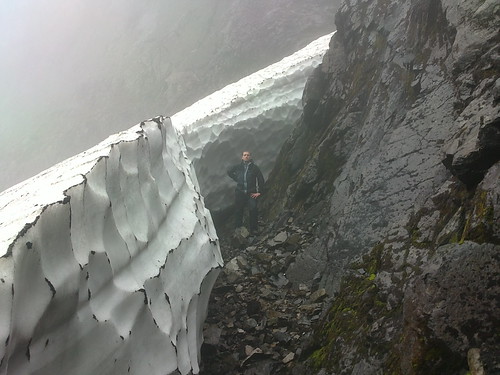
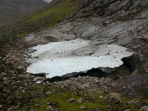
We reached the snow (1130m) eventually, and found it to be ~95m long, and still reasonably deep (in the region of 6m in the middle I would say).
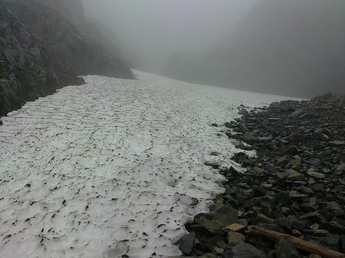
On the way down we popped across to Point 5 Gully, to photograph the snows there. This is the snow you can see from the road at Torlundy.
From there we retreated down the gully again and round the bottom of the north-east buttress, across the little lochan at the head of Coire Leis and up onto the Carn Mor Dearg arete, around
here. Coming up the final gully was a bit of a scramble, and I assisted my brother by climbing to the head of the gully and throwing him some rope down. Good move! Never underestimate the handiness of rope if you're climbing steep slipply grassy gullies!
From there it was a case of follow the line to the bealach between Carn Mor Dearg and Aonach Mor. This route was pioneered(!) a couple of years ago when I did the route with
Blair Fyffe, who has a sniffer-dog instinct for picking out an easy route.
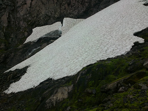
The path from the unnamed bealach at 830m to the summit plateau is steep, but pleasant. It gains height quickly, and before too long we were on the plateau. I sped across to the edge of the corrie to see the snow-patch that lies in the shadow of Aonach Beag's north face,
here. This patch has been present since 2006, and is approaching 4-years old. In 2007 & 2008 it was the largest patch to survive 'til winter, despite it sitting at an incredibly low altitude of 955m.
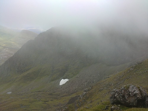
We walked in thick mist to the top of Aonach Mor, where we had our first Munro of the day, despite having climbed 1600m thus far! Fatigue had well-and-truly set in for my brother by then, so I let him off the final 120m descent and ascent of Coire an Lochain, which also held some snow. Again, I dropped from the summit plateau (where it's not so steep) and came into Coire an Lochain
here, as it's virtually impossible to enter it directly because of the sheer cliffs. There I found a reasonable patch behind a
protalus rampart, which is invisible from below, as you'll see from the picture. The rampart shields it from the view below.
From there I had two options: head across to Climber's Col, or the more direct Easy Gully. Easy Gully is, in wet weather, very slippery. It's also steep, and a slip there could result in a sticky end. However, I've
done it before when it was dry. Also, I had given my brother the rope, and he was waiting at the head of the gully with all 30m of it unfurled and waiting! In the end I came up without too much of a problem, although the bouler I kicked down by mistake went for hundreds of metres before coming to a stop.
From there it was down the Goose and then the mountain bike track to the car park. The sting in the tail was the 2.5-mile trek back to the car park at Torlundy. I so didn't need that, and nor did my brother, who subsequently told me he lost 5lbs during the course of the walk, despite eating and drinking copiously.
